Wow. I don't know where to start, there's so much cancer in this thread.
Read Ent's posts, found them interesting. Read the replies (except for the bits censored for profanity) and found a lot of them to be over the top. They read like homages to Monty Python's Four Yorkshiremen ("Luxury! We used to have to get out of the lake at six o'clock in the morning, clean the lake, eat a handful of 'ot gravel, work twenty hour day at mill for tuppence a month, come home, and Dad would thrash us to sleep with a broken bottle, if we were lucky!")
I agree with a lot of what Ent's saying. I think you're kidding yourselves if you think the old timers would have turned down useful technology - Mitchell didn't use chains to measure distances because he liked carrying around heavy rusty metal ... he used them because they were the best available technology at the time.
I have nothing against people who like to do things old-school. For example, I really love this guy's stuff https://www.youtube.com/user/historicaltrekking ... he does it really old school (uses only 18th Century technology.) So if you want to learn how to make a good flint, striker, char-cloth and use it to make fire ... go ahead, and by all means tell me what you learn.
But do not, please, rail at people who want to use matches, Zippos or ferro-cesium fire-lighters. And please do not go on to justify your preference for real chert flints by claiming that people who use matches are just arsonists ... because that, it seems to me, is directly analogous to what I'm reading by way of rebuttal and response to Ent.
If you want to do it really old school and use nothing that wasn't available during the paleolithic, then go right ahead ... but please don't shout down the people who swear by flint and fire fungus!
If bushwalk.com is dedicated only to bushwalking within a certain historical period, then please make it clear what period's Equipment is acceptable in Techno-Babble, as it would seem 21st Century is too modern. If discussion of GPS accuracy isn't acceptable in Techno-Babble on bushwalk.com, then I think Ent's right, and the dominant culture here really is luddite masquerading as old school.
Improved GPS Accuracy
68 posts
• Page 2 of 3 • 1, 2, 3
-

colinm - Athrotaxis cupressoides

- Posts: 388
- Joined: Wed 27 Jul, 2011 10:39 am
- Region: New South Wales
- Gender: Male
Re: Improved GPS Accuracy
![]() by frenchy_84 » Tue 15 Jan, 2013 3:39 pm
by frenchy_84 » Tue 15 Jan, 2013 3:39 pm
There is a lot of forum history your missing that boiled over in this post. You will notice that my first reply discusses the article and GPS accuracy. Ent in his usual style disregards all of this and continues with his trademark rant. The rant which is a pretty regular occurrence in multiple threads. So I lost my temper and wrote a few words that needed to be censored.
Im more than happy to discuss the introduction of L5 signal to GPS, it will be great for a lot of different applications. I still don't see how you can sub metre accuracy with out a correction service which introduces the additional challenges of either radio comms, 3g connection or satellite subscription service.
And I'm still waiting for a convincing argument as to why/how sub metre accuracy can be beneficial for bushwalking
-

frenchy_84 - Athrotaxis selaginoides

- Posts: 1510
- Joined: Tue 04 Nov, 2008 7:00 pm
- Region: Queensland
- Gender: Male
Re: Improved GPS Accuracy
![]() by colinm » Tue 15 Jan, 2013 6:22 pm
by colinm » Tue 15 Jan, 2013 6:22 pm
frenchy_84 wrote:I still don't see how you can sub metre accuracy with out a correction service which introduces the additional challenges of either radio comms, 3g connection or satellite subscription service.
In the short term? Nor do I. Medum/long term ... well, if I'd been asked to predict GPS in the 80s I'd have said it wasn't possible.
frenchy_84 wrote:And I'm still waiting for a convincing argument as to why/how sub metre accuracy can be beneficial for bushwalking
That's the more interesting question, I think. I'm currently comparing the cliff lines on old sketch maps against the LPI topos and 1sDEM ... at this point I think I'd be happy with 100m accuracy - it's absent, from what I can see.
We'll get really precise positioning of tracks, over time, with aggregation over systems like OSM (many samples/tracks can be aggregated to increase precision.) So it's already here ... what do we do with it?
sig pending approval
-
colinm - Athrotaxis cupressoides
- Posts: 388
- Joined: Wed 27 Jul, 2011 10:39 am
- Region: New South Wales
- Gender: Male
Re: Improved GPS Accuracy
![]() by photohiker » Tue 15 Jan, 2013 7:22 pm
by photohiker » Tue 15 Jan, 2013 7:22 pm
colinm wrote:That's the more interesting question, I think. I'm currently comparing the cliff lines on old sketch maps against the LPI topos and 1sDEM ... at this point I think I'd be happy with 100m accuracy - it's absent, from what I can see.
That's map accuracy you're talking about, not GPS accuracy, isn't it?
I agree that if the maps are accurate, GPS accuracy is mostly more than good enough.
Michael
-

photohiker - Lagarostrobos franklinii

- Posts: 3097
- Joined: Sun 17 May, 2009 12:31 pm
- Location: Adelaide, dreaming up where to go next.
Re: Improved GPS Accuracy
![]() by colinm » Tue 15 Jan, 2013 7:47 pm
by colinm » Tue 15 Jan, 2013 7:47 pm
1) GPS can be used to improve map accuracy at least with respect to tracks. Accurate tracks can be used to check the accuracy of features which are hard to accurately render from aerial photography (such as cliffs.)
Here's an example of a track which appears (on the map) to go over a cliff which may or may not actually be there:

Same thing, with photo as background:

2) GPS is also not uniformly accurate. Greater point accuracy may also entail better 'coverage' ... less inaccuracy under trees, etc.
3) greater accuracy would give better data for analyses like this https://docs.google.com/folder/d/0B0PI7 ... lXeEk/edit, which could give more accurate calculation of time to complete segments of a bushwalk.
Here's an example of a track which appears (on the map) to go over a cliff which may or may not actually be there:
Same thing, with photo as background:
2) GPS is also not uniformly accurate. Greater point accuracy may also entail better 'coverage' ... less inaccuracy under trees, etc.
3) greater accuracy would give better data for analyses like this https://docs.google.com/folder/d/0B0PI7 ... lXeEk/edit, which could give more accurate calculation of time to complete segments of a bushwalk.
sig pending approval
-
colinm - Athrotaxis cupressoides
- Posts: 388
- Joined: Wed 27 Jul, 2011 10:39 am
- Region: New South Wales
- Gender: Male
Re: Improved GPS Accuracy
![]() by photohiker » Tue 15 Jan, 2013 10:00 pm
by photohiker » Tue 15 Jan, 2013 10:00 pm
colinm wrote:1) GPS can be used to improve map accuracy at least with respect to tracks. Accurate tracks can be used to check the accuracy of features which are hard to accurately render from aerial photography (such as cliffs.)
Here's an example of a track which appears (on the map) to go over a cliff which may or may not actually be there:
Same thing, with photo as background:
2) GPS is also not uniformly accurate. Greater point accuracy may also entail better 'coverage' ... less inaccuracy under trees, etc.
3) greater accuracy would give better data for analyses like this https://docs.google.com/folder/d/0B0PI7 ... lXeEk/edit, which could give more accurate calculation of time to complete segments of a bushwalk.
Clearly,
1. The map appears to be accurate, as the GPS plot seems to follow the path on the map accurately, not crossing the cliff.
2. In the aerial image, the GPS plot appears to go over the cliff. This would suggest that there is a georeference issue with the aerial. GPS will not solve this problem (unless GPS points are used to georeference the aerial image)
3. We would expect to hear from a hiker that they walked off a cliff, rescaled the cliff keeping to an imaginary path to continue of the defined track, (unlikely) otherwise we can discern that the map is reasonably accurate and the aerial image is not.
Michael
-
photohiker - Lagarostrobos franklinii
- Posts: 3097
- Joined: Sun 17 May, 2009 12:31 pm
- Location: Adelaide, dreaming up where to go next.
Re: Improved GPS Accuracy
![]() by colinm » Tue 15 Jan, 2013 10:22 pm
by colinm » Tue 15 Jan, 2013 10:22 pm
photohiker wrote:1. The map appears to be accurate, as the GPS plot seems to follow the path on the map accurately, not crossing the cliff.
2. In the aerial image, the GPS plot appears to go over the cliff. This would suggest that there is a georeference issue with the aerial. GPS will not solve this problem (unless GPS points are used to georeference the aerial image)
3. We would expect to hear from a hiker that they walked off a cliff, rescaled the cliff keeping to an imaginary path to continue of the defined track, (unlikely) otherwise we can discern that the map is reasonably accurate and the aerial image is not.
I don't think the track's accurate - it's from an old sketch map, I think the track is derived from that, not from walking. If it were from walking, we'd have a much better picture. QED
I know the maps's inaccurate: the red polygons overlaying the photo are the NSW topo cliff areas. You can see it tracks the cliff for some of its extent, you can also see it follows some of the other cliff lines visible from the photo.
The pseudo-colouring in the first image, and the contours you can dimly see, are derived from one-second DEM - the topo cliff line does not conform to the DEM elevations.
This area's topo maps were drawn from a set of (possibly stereoscopic) photos, maybe 30-50 years ago, the photos they had were of pretty low quality. The thing is riddled with fail.
We have better technology now, high precision GPS (to better georeference new aerial photos and to provide walker feedback.) We can expect to have better maps now, even if we have to draw them ourselves.
Last edited by colinm on Tue 15 Jan, 2013 11:25 pm, edited 1 time in total.
sig pending approval
-
colinm - Athrotaxis cupressoides
- Posts: 388
- Joined: Wed 27 Jul, 2011 10:39 am
- Region: New South Wales
- Gender: Male
Re: Improved GPS Accuracy
![]() by colinm » Tue 15 Jan, 2013 10:36 pm
by colinm » Tue 15 Jan, 2013 10:36 pm
I'm sorry, I'm an idiot - I had the wrong track. The blue one in this is the hiked track (courtesy John Evans.)
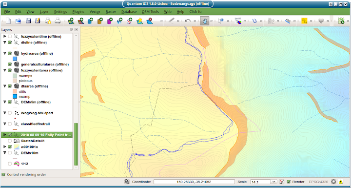
You can see that it trims the topo 'cliff', but (it should be clear) it doesn't approach the actual cliff. The black dashed line is the topo's idea of the track. The actual cliff can be seen from the contours. I was responsible for the pink track - I'd traced it from an improperly georeferenced old map, for comparison, and then gotten confused as to which was which.
Point is: the topo's *way* out, the GPS track is informative, it conforms to the contours. The more accurate a GPS track, the more informative and useful it is.
BTW: I accept I'm missing a lot of forum history ... I'm just here for the techno-babble!
sig pending approval
-
colinm - Athrotaxis cupressoides
- Posts: 388
- Joined: Wed 27 Jul, 2011 10:39 am
- Region: New South Wales
- Gender: Male
Re: Improved GPS Accuracy
![]() by colinm » Tue 15 Jan, 2013 11:18 pm
by colinm » Tue 15 Jan, 2013 11:18 pm
walkinTas wrote:Read some history - its fun!People were going there before maps and GPS and rescue helicopters existed. Nothing stopped them then, and nothing stops anyone now.
Yeah, really. No doubt they were tough in those days. Here's a small section of a map of a pioneering hike in 1957 which included one Alex Colley http://bit.ly/VY5jPa. I have tried to georeference it against the currently available data, and would like to draw your attention to two facts:
(1) There is no Mountain where I noted this in red.
(2) Alex Colley complained bitterly about how bad a campsite CAMP4 was: "The moving of rocks served only to uncover similar ones below. And so the five unwise bushwalkers, who were old enough to know better, got the campsite they deserved"
walkinTas wrote:It is easier now than it ever was. Building footpaths and roads and resorts or erecting signs and shelters to make it less remote and less wild does not make wilderness more accessible. ....it just destroys one more bit of wilderness.
Yes, footpaths, roads, resorts, etc etc are bad. I think the hikers back then made a virtue of necessity, and one should (and I do) admire their tenacity, skill and bravery ... but I'm not going to make a fetish of it. Those folk used whatever they could to achieve their goals and so will I.
sig pending approval
-
colinm - Athrotaxis cupressoides
- Posts: 388
- Joined: Wed 27 Jul, 2011 10:39 am
- Region: New South Wales
- Gender: Male
Re: Improved GPS Accuracy
![]() by photohiker » Wed 16 Jan, 2013 7:32 am
by photohiker » Wed 16 Jan, 2013 7:32 am
colinm wrote:I'm sorry, I'm an idiot - I had the wrong track. The blue one in this is the hiked track (courtesy John Evans.)
No you're not,
The interesting thing is that current GPS accuracy is what it is, and unless it goes crazy on you as it does in deep tree cover or deep valleys, it's surprisingly consistent and with a number of traces of the same path very accurate for mapping already. Opening up the GPS traces of a highway in an OSM editor like Potlach verifies that. Sure, some are way off, if you have one of those units, ditch it
When using OSM and walking a track, often my GPS shows me to be bang on the track. GPS derived maps suit GPS navigation.
Michael
-
photohiker - Lagarostrobos franklinii
- Posts: 3097
- Joined: Sun 17 May, 2009 12:31 pm
- Location: Adelaide, dreaming up where to go next.
Re: Improved GPS Accuracy
![]() by Ent » Wed 16 Jan, 2013 10:35 am
by Ent » Wed 16 Jan, 2013 10:35 am
I found when playing with many GPSs not all created equal. What was curious one was consistently out creating a railway track plot when compared to other units. About ten metres from memory. Curious indeed.
OSM mappers will combine numerous plots to get an average that is hopefully more accurate than an individual plot. Bing photos can be a varying degree out with some apparently hundred metres out. It is good to get reference points that are visible and then align the with waypoints obtained from the averaging method. Huts are good for that sort of thing.
A good plot to follow and reliable GPS makes for much easier snow walking in dense vegetation areas. Also when coming in from off track to hit the track.
Cheers
"lt only took six years. From now on, l´ll write two letters a week instead of one."
(Shawshank Redemption)
(Shawshank Redemption)
-

Ent - Lagarostrobos franklinii
- Posts: 4059
- Joined: Tue 13 May, 2008 3:38 pm
- Region: Tasmania
Re: Improved GPS Accuracy
![]() by taswegian » Sun 27 Jan, 2013 2:11 pm
by taswegian » Sun 27 Jan, 2013 2:11 pm
Wonder if anyone has thought of continental drift?
75mm per year and in 10 years suddenly a 1 or sub meter GPS is irrelevant unless you know what it all means.
A GPS is a measuring tool. But unlike a tape measure or a laser measuring device, both of which give distances there is much more to GPS than spitting out a set of coordinates when accuracy is important.
To take a fauna study for example. Would the user know what or how to corelate old data to new data? AGD66 to GDA is an example. (I've seen some clangers there by unsuspecting yet genuine people)
That's a large scale shift but it's all relevant. But 10-15 years later something is moved a metre and suddenly it becomes interesting. Has 'it' moved or just the artificial grid system mankind has placed over 'it'?
Frenchy has some legitimate concerns here as do others. Just all needs to be in context.
-

taswegian - Phyllocladus aspleniifolius

- Posts: 899
- Joined: Tue 27 Jul, 2010 8:34 pm
- Region: Tasmania
- Gender: Male
Re: Improved GPS Accuracy
![]() by photohiker » Sun 27 Jan, 2013 5:48 pm
by photohiker » Sun 27 Jan, 2013 5:48 pm
taswegian wrote:Wonder if anyone has thought of continental drift?
75mm per year and in 10 years suddenly a 1 or sub meter GPS is irrelevant unless you know what it all means.
A GPS is a measuring tool. But unlike a tape measure or a laser measuring device, both of which give distances there is much more to GPS than spitting out a set of coordinates when accuracy is important.
Yep, GDA have a FAQ for that:
How will 'continental drift' affect GDA?
The Australian plate is moving in a north easterly direction at a rate of about 7 cm per year, but there is little known distortion within the plate. That means the latitude and longitude of points in Australia, measured in a world-wide system, are changing slowly but constantly.
The definition of the GDA94 datum includes fixed values for certain geodetic reference points in Australia. The values of these will remain fixed. GDA94 position values, therefore, are NOT affected by continental drift. The RELATIONSHIP of positions to each other, such as between 2 seismic shots, or of an object relative to the Trigonometric beacon used to locate that object, will NOT change.
However, ABSOLUTE positions in Australia, measured in a world-wide system, will change over the long term. WGS84 is such a world-wide system. This is one of the reasons why the exact relationship between GDA94 and WGS84 coordinates for points is not constant.
In the future, GPS systems which measure absolute positions to centimetre precision, may become commonly available. This will necessitate new rules for dealing with the gradual change of absolute positions.
Next question, do the current GPS units take this into account? ie. If you select GDA94 as your datum, is it corrected for continental drift to the current date?
Michael
-
photohiker - Lagarostrobos franklinii
- Posts: 3097
- Joined: Sun 17 May, 2009 12:31 pm
- Location: Adelaide, dreaming up where to go next.
Re: Improved GPS Accuracy
![]() by taswegian » Sun 27 Jan, 2013 6:37 pm
by taswegian » Sun 27 Jan, 2013 6:37 pm
GDA is static. Otherwise we'd have some interesting issues mainly with true coordinates.
GDA94 is not corrected or take into account the drift.
One day the powers to be will have to decide what the next datum will be.
They are fully aware of this. My comment was aimed at those that take GPS in a simplistic format, read the output, record same and then expect to reproduce a point on the ground in? years ahead and wonder why something isn't where it's supposed to be.
As this topic was about more accurate consumer grade GPS units it made that scenario particularly interesting in the hands of the innocent.
-
taswegian - Phyllocladus aspleniifolius
- Posts: 899
- Joined: Tue 27 Jul, 2010 8:34 pm
- Region: Tasmania
- Gender: Male
Re: Improved GPS Accuracy
![]() by photohiker » Sun 27 Jan, 2013 8:10 pm
by photohiker » Sun 27 Jan, 2013 8:10 pm
taswegian wrote:GDA is static. Otherwise we'd have some interesting issues mainly with true coordinates.
GDA94 is not corrected or take into account the drift.
One day the powers to be will have to decide what the next datum will be.
Correct.
GDA94 was more or less aligned with WGS84 when it was released. We're nearly 20 years forward now, so a whole 1.5m away from the initial alignment. That's hardly a disaster when you're walking a rough bush track and your GPS displays 3M accuracy anyway, but if you're looking to dig up the pirate treasure you buried 20 years ago, it might be worth taking the drift into account to save extra digging.
Openstreetmap uses WGS84 so accuracy of tracks drawn from GPS logs depends on the accuracy of the GPS and the age of the recorded tracks, neither of which is marked on the provided mapping. All the same, OSM provides remarkably accurate mapping when used with a GPS.
Michael
-
photohiker - Lagarostrobos franklinii
- Posts: 3097
- Joined: Sun 17 May, 2009 12:31 pm
- Location: Adelaide, dreaming up where to go next.
Re: Improved GPS Accuracy
![]() by colinm » Sun 27 Jan, 2013 11:48 pm
by colinm » Sun 27 Jan, 2013 11:48 pm
It's a good thing GPS tracks are tagged with time, which makes the requisite transformation trivial.
(While we're nit-picking: GPS-time hasn't been in sync with GMT for decades as it doesn't account for the slowing of the earth's rotation or the leap-seconds we've added as a consequence.)
The forecast higher precision (not accuracy) is nonetheless useful.
(While we're nit-picking: GPS-time hasn't been in sync with GMT for decades as it doesn't account for the slowing of the earth's rotation or the leap-seconds we've added as a consequence.)
The forecast higher precision (not accuracy) is nonetheless useful.
sig pending approval
-
colinm - Athrotaxis cupressoides
- Posts: 388
- Joined: Wed 27 Jul, 2011 10:39 am
- Region: New South Wales
- Gender: Male
Re: Improved GPS Accuracy
![]() by photohiker » Mon 28 Jan, 2013 7:44 am
by photohiker » Mon 28 Jan, 2013 7:44 am
Tagged GPX files would be easy to correct, but OSM traces not so much - OSM currently uses Bing aerial imagery but has used both NearMap and Yahoo imagery in the past, many traces are based on this imagery. Even those traces based solely on GPS can only identified if they have been tagged correctly, which in my experience is a hit or miss affair.
Searching the OSM wiki for continental drift reveals nothing useful. The mailing lists show that some contributors understand the issues.
I think OSM may rely on users identifying inaccuracies against WGS84 and correcting them as they become apparent.
Searching the OSM wiki for continental drift reveals nothing useful. The mailing lists show that some contributors understand the issues.
I think OSM may rely on users identifying inaccuracies against WGS84 and correcting them as they become apparent.
Michael
-
photohiker - Lagarostrobos franklinii
- Posts: 3097
- Joined: Sun 17 May, 2009 12:31 pm
- Location: Adelaide, dreaming up where to go next.
Re: Improved GPS Accuracy
![]() by Rob A » Mon 28 Jan, 2013 9:34 am
by Rob A » Mon 28 Jan, 2013 9:34 am
photohiker wrote:but if you're looking to dig up the pirate treasure you buried 20 years ago
It would still be in the same GDA94, and it that would still be the same as the WGS84 you buried it to.
colinm wrote:GPS-time hasn't been in sync with GMT for decades as it doesn't account for the slowing of the earth's rotation or the leap-seconds we've added as a consequence.)
The UT(s) are still aligned(+/-) though.
Every four seconds, somewhere in the world, an Harlequin Mills and Boon is sold ... Wot ...
- Rob A
- Phyllocladus aspleniifolius
- Posts: 506
- Joined: Mon 29 Nov, 2010 2:01 pm
- Region: New South Wales
- Gender: Male
Re: Improved GPS Accuracy
![]() by photohiker » Mon 28 Jan, 2013 10:30 am
by photohiker » Mon 28 Jan, 2013 10:30 am
Rob A wrote:photohiker wrote:but if you're looking to dig up the pirate treasure you buried 20 years ago
It would still be in the same GDA94, and it that would still be the same as the WGS84 you buried it to..
It would be at the same GDA94 location, but not the same WGS due to continental drift. It would be about 1.5 metres away from the same plotted WGS84 location.
Michael
-
photohiker - Lagarostrobos franklinii
- Posts: 3097
- Joined: Sun 17 May, 2009 12:31 pm
- Location: Adelaide, dreaming up where to go next.
Re: Improved GPS Accuracy
![]() by Rob A » Mon 28 Jan, 2013 11:16 am
by Rob A » Mon 28 Jan, 2013 11:16 am
The GDA would be the same numerical as the wgs you burried it to.
Unless you are in Laos, in which case the treasure might well have tumbled five or ten meteres away from where you stuck it?
Had you buried it ten year ago to a wgs, the answer would be different.
Unless you are in Laos, in which case the treasure might well have tumbled five or ten meteres away from where you stuck it?
Had you buried it ten year ago to a wgs, the answer would be different.
Every four seconds, somewhere in the world, an Harlequin Mills and Boon is sold ... Wot ...
- Rob A
- Phyllocladus aspleniifolius
- Posts: 506
- Joined: Mon 29 Nov, 2010 2:01 pm
- Region: New South Wales
- Gender: Male
Re: Improved GPS Accuracy
![]() by photohiker » Mon 28 Jan, 2013 12:53 pm
by photohiker » Mon 28 Jan, 2013 12:53 pm
Rob A wrote:The GDA would be the same numerical as the wgs you burried it to.
Unless you are in Laos, in which case the treasure might well have tumbled five or ten meteres away from where you stuck it?
Had you buried it ten year ago to a wgs, the answer would be different.
Sorry RobA, we seem to on different tracks
The original comment was referring to treasure buried 20 years ago. The GDA94 would still describe it's position, the WGS84 would be about a meter and a half off today.
The difference being GDA94 is anchored to Australia so continental drift has little effect. The WGS is not anchored to Australia, and Australia is moving around 7cm per year.
Michael
-
photohiker - Lagarostrobos franklinii
- Posts: 3097
- Joined: Sun 17 May, 2009 12:31 pm
- Location: Adelaide, dreaming up where to go next.
Re: Improved GPS Accuracy
![]() by Rob A » Mon 28 Jan, 2013 4:14 pm
by Rob A » Mon 28 Jan, 2013 4:14 pm
Yea but when you wrote down the position of the burried treasure, the numbers you wrote down twenty years ago (in either MGR or GDA) will be the same numbers you still use on your GDA when you go to find it, whatever year you chose to recover it. Thats the good thing about GDA, its not fixed and it moves with the times. Domestic coordinates within that (plate), therefore get stability.
I really couldnt understand why you would ask "If you select GDA94 as your datum, is it corrected for continental drift to the current date?"
Anyway, more likely you were still stuck in AGD66 when you buried it. Youll never find it.
I really couldnt understand why you would ask "If you select GDA94 as your datum, is it corrected for continental drift to the current date?"
Anyway, more likely you were still stuck in AGD66 when you buried it. Youll never find it.
Last edited by Rob A on Mon 28 Jan, 2013 4:43 pm, edited 1 time in total.
Every four seconds, somewhere in the world, an Harlequin Mills and Boon is sold ... Wot ...
- Rob A
- Phyllocladus aspleniifolius
- Posts: 506
- Joined: Mon 29 Nov, 2010 2:01 pm
- Region: New South Wales
- Gender: Male
Re: Improved GPS Accuracy
![]() by photohiker » Mon 28 Jan, 2013 4:29 pm
by photohiker » Mon 28 Jan, 2013 4:29 pm
Rob A wrote:I really couldnt understand why you would ask "If you select GDA94 as your datum, is it corrected for continental drift to the current date?"
I was talking about selecting GDA94 on your GPS, and asking if it is corrected.
GPS works on WGS84 internally regardless of which datum you select on the unit. So the question remains, when viewing GDA94 coordinates on your GPS, does the GPS translate WGS into GDA94 based on the continental drift since 1994 when the two datums were closely aligned, or does it assume the two datums are still aligned?
For walking, a metre and a half is splitting hairs, but I'd still like to know.
Michael
-
photohiker - Lagarostrobos franklinii
- Posts: 3097
- Joined: Sun 17 May, 2009 12:31 pm
- Location: Adelaide, dreaming up where to go next.
Re: Improved GPS Accuracy
![]() by photohiker » Mon 28 Jan, 2013 4:44 pm
by photohiker » Mon 28 Jan, 2013 4:44 pm
Rob A wrote:Yea but when you wrote down the position of the burried treasure, the numbers you wrote down twenty years ago (in either MGR or GDA) will be the same numbers you still use on your GDA when you go to find it,
Not quite. When I buried the treasure twenty years ago, GDA94 was just announced and not on my GPS. I used WGS84 and saved a waypoint.
Michael
-
photohiker - Lagarostrobos franklinii
- Posts: 3097
- Joined: Sun 17 May, 2009 12:31 pm
- Location: Adelaide, dreaming up where to go next.
Re: Improved GPS Accuracy
![]() by Rob A » Mon 28 Jan, 2013 4:48 pm
by Rob A » Mon 28 Jan, 2013 4:48 pm
"The definition of the GDA94 datum includes fixed values for certain geodetic reference points in Australia."
I should imagine it absolutely ignores it, as being not relevant. All the GPS can do is take make distances from the satelites via the time code. String of binary numbers. Try Garmin.
84 got updated in 2004, Ive no idea what the coordinate changes would be. Split hairs on a planet change of a hundred meters?
Every four seconds, somewhere in the world, an Harlequin Mills and Boon is sold ... Wot ...
- Rob A
- Phyllocladus aspleniifolius
- Posts: 506
- Joined: Mon 29 Nov, 2010 2:01 pm
- Region: New South Wales
- Gender: Male
Re: Improved GPS Accuracy
![]() by frenchy_84 » Tue 29 Jan, 2013 9:22 am
by frenchy_84 » Tue 29 Jan, 2013 9:22 am
Lots of different accuracies have been brought up here, GPS measurement accuracy, Map accuracy, OSM GPS plot accuracy and even datum errors/accuracies. And I’m still yet to hear a convincing argument as to how having a sub metre GPS is advantageous to bushwalking. When I first thought about this, I imagined just using a HH GPS with a background map, and so if your 5m from your true position on a 1:25000 map you’re not even going to be able to pick up on it let along care about it. However, yes if you have a GPS plot to follow then you would be able to tell. Let’s for argument sake say you have a plot to follow that has a true accuracy of 20mm, if you are in a situation where you will get in to trouble if your to verge 5m either side of this path and you can’t see this danger (whiteout, night time or whatever) then you’re in a whole lot of trouble that no technology is going to help. I spend most my days staking out lines with a 20mm accuracy GPS and trust me you can’t follow the line without verging off it, most of my day is spent walking around in *&%$#! circles. So if you cant physically follow a line to submetre accuracy what is the point of a GPS telling you to submetre accuracy.
Rob A you are correct that if you store coordinates in GDA94 then comeback 20 years and set them out in GDA94 then continental drift wont be an issue. However most HH GPS do not give coordinates in GDA94 they give them in UTM coordinates which are not static and are only correct for that certain point in time. For all HH GPS purposes UTM and GDA94 can be used interchangeably because even now the difference is only around a metre.
I also think we have jumped the gun on this as well, because HH GPS can’t even use L1 or L2 signals so why on earth are they going to start using L5? Where L5 is most advantageous is by improving the Ionosphere correction (as its a different wavelength to L1 and L2) So triple frequency GPS receivers (when the come available) in Planes and survey grade GPS will see an increase in accuracy.
-
frenchy_84 - Athrotaxis selaginoides
- Posts: 1510
- Joined: Tue 04 Nov, 2008 7:00 pm
- Region: Queensland
- Gender: Male
Re: Improved GPS Accuracy
![]() by colinm » Tue 29 Jan, 2013 10:41 am
by colinm » Tue 29 Jan, 2013 10:41 am
frenchy_84 wrote:Lots of different accuracies have been brought up here, GPS measurement accuracy, Map accuracy, OSM GPS plot accuracy and even datum errors/accuracies.
I think we have to distinguish between accuracy (a measure of how repeatable a measurement is) and precision (over how large an area range (in this case) an individual measurement might vary.) The OP got the distinction wrong.
frenchy_84 wrote:And I’m still yet to hear a convincing argument as to how having a sub metre GPS is advantageous to bushwalking.
An extremely precise GPS might locate a specific rock/cairn/pass. I think that could be advantageous. It would be required to give a precise LIDAR derived elevation model (admittedly, not a hand-held unit.) It would certainly be useful in deriving terrain metrics (just how rough is this track, by how long it took to walk it.)
A more accurate GPS would presumably give more accurate elevation (mine has an altimeter.)
I'm not seeing the downside.
sig pending approval
-
colinm - Athrotaxis cupressoides
- Posts: 388
- Joined: Wed 27 Jul, 2011 10:39 am
- Region: New South Wales
- Gender: Male
Re: Improved GPS Accuracy
![]() by photohiker » Tue 29 Jan, 2013 11:37 am
by photohiker » Tue 29 Jan, 2013 11:37 am
I'm not seeing the downside, but then my expectation is that there won't be much of an upside either.
When it comes, there will be fanfare and many will have found a reason to upgrade I guess. Personally, If the battery life is better, the screen better, the casing more robust and lighter, etc and my old unit has had the richard, then sure I might upgrade.
When it comes, there will be fanfare and many will have found a reason to upgrade I guess. Personally, If the battery life is better, the screen better, the casing more robust and lighter, etc and my old unit has had the richard, then sure I might upgrade.
Michael
-
photohiker - Lagarostrobos franklinii
- Posts: 3097
- Joined: Sun 17 May, 2009 12:31 pm
- Location: Adelaide, dreaming up where to go next.
Re: Improved GPS Accuracy
![]() by frenchy_84 » Tue 29 Jan, 2013 12:06 pm
by frenchy_84 » Tue 29 Jan, 2013 12:06 pm
colinm wrote:A more accurate GPS would presumably give more accurate elevation (mine has an altimeter.)
Yours uses an altimeter because GPS measures elevations relative to the ellipsoid not AHD. To change from ellipsodial heights to AHD requires a geoid model, as far as im aware HH GPS do not come with geoid models so increasing the vertical measurement accuracy of GPS thru introduction of L5 signal will have no bearing on this.
colinm wrote:I'm not seeing the downside.
Cost and Comms. I still do not see how we can get submetre GPS without a correction service of some sort which will require either 3g, radio, or satelitte subscription service which in itself brings extra hardware, weight, cost and power consumption. And even if they manage it without a correction service there will still be increased cost. Would you honestly pay more for a device that when a standard gps gets you to the cain/feature you want the new GPS will say acuatally its 1.5m to your right?
-
frenchy_84 - Athrotaxis selaginoides
- Posts: 1510
- Joined: Tue 04 Nov, 2008 7:00 pm
- Region: Queensland
- Gender: Male
Re: Improved GPS Accuracy
![]() by photohiker » Tue 29 Jan, 2013 12:19 pm
by photohiker » Tue 29 Jan, 2013 12:19 pm
frenchy_84 wrote:Would you honestly pay more for a device that when a standard gps gets you to the cain/feature you want the new GPS will say acuatally its 1.5m to your right?
I'd consider it, but only if it came with other benefits mentioned previously. If they wanted more for a device that chewed batteries faster, weighed more, and required a subscription service, then I'd let it pass.
Michael
-
photohiker - Lagarostrobos franklinii
- Posts: 3097
- Joined: Sun 17 May, 2009 12:31 pm
- Location: Adelaide, dreaming up where to go next.
68 posts
• Page 2 of 3 • 1, 2, 3
Who is online
Users browsing this forum: No registered users and 4 guests