Here is my first track report, for my first overnighter
Apologies for my rambling chatty style, but that's just me.
Rewritten elsewhere, and cut and pasted here, after the site decided to gobble up my original report when i pressed 'submit' (grumble grumble, expletive, time to pour a glass of wine!)
The Coast Track (Otford to Bundeena) Track Report
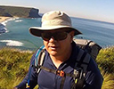
Being a very popular walking track, I know that this information is available in many guidebooks and the Wildwalks website, but I thought I’d offer my observations and a little different perspective. I just completed this yesterday, as my first solo overnight walk.
I am 46, female, of only moderate fitness. I usually go on walks with my husband, and sometimes my teenage children.
I decided to start from Otford, and walk north to Bundeena, a distance of approx 27 km. I’ll outline my reasons for doing it in this direction at the end. I have read here about people doing the complete walk in one day, over 7.5 hours, but I walk a lot slower than this, and enjoyed doing it over 2 days, with time to stop and take photos, admire scenery, and stopping and chatting to people on the track
I parked my car at Otford Station, because I didn’t want to leave it overnight at Otford Lookout, on the roadside. Otford Station is pretty small and quiet. I left there at noon on a Wednesday, which allowed me to get some things done at home (getting kids off to school, washing hung out, kitchen tidied and other mundane domestic stuff) You access the start of the walk by crossing over the railway tracks via the overpass, and going up some steep stairs. The sign for the Coast Walk is just before a steep bitumen slope. It takes about 15 - 20 minutes to get to the lookout.
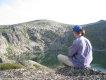
At the Lookout there are great views south to Wollongong. You go up the steps and the track winds up, amongst banksias and rocks, then it becomes flatter and sandier and there are areas with lovely ferns, and lots of wildflowers and gymea lilly spikes. You then make your way down through some thicker bushland. The vegetation is quite varied. I stopped on a rocky platform, set up my folding chair in the shade and admired the view while I had my sandwiches for lunch. An interesting area is through some dense shady palms, called appropriately ‘Palm Jungle’. I can imagine this may get muddy after rain. Several small creeks I passed were dry, or just stagnant pools. You pass a little ranger’s hut tucked away in some trees to the right, then it opens up onto a grassy hill.
The grasses are quite tough and spikey, and I was a bit worried about snakes. I usually wear long pants and goretex gaiters, but because it was pretty hot I was wearing shorts and ankle length gaiters. I use walking poles, so I hoped that if I came across a snake they’d contact it first, before I did! Luckily I didn’t come across any snakes on this walk. The track is pretty narrow and eroded in parts here, with ground level sometimes being waist high. In some areas there is track work, but it doesn’t look as if there has been any recent activity. Towards the north end there are some areas of raised walkway.
I elected not to do the little sidetrack that turns off right here, to the Figure of Eight tidal pools at the base of the headland, as it was high tide, and there was a large swell, making it too dangerous.
Burning Palms is a beach that has a few cabins, and a Surf Life saving Club. There is no water available here. Continue on following the sign to North Era. You crest a hill and a large expanse of sandy rabbit-mown lawn area, overlooking the National Trust protected South Era shack community. The path becomes indistinct here, and I felt like I was trespassing in people’s backyards. There is a metal bridge that crosses the small creek, but I missed the approach to that, and so walked along the beach in front of the lagoon until I could cross back up. The SLSC has had the head removed from the external tap so there is no access to water here. On the northern side the track is once again confusing, but just keep following the little paths up past the cabins, and eventually it takes you up and over the hilll, until you’re looking down over North Era beach.
This section took me just over 3 hours, and is approx 6 km, so my walking pace was only 2 km/hr.
North Era is the only official camping area on the Coastal Track. The camping site seen on many maps at at Providential Head near Watamolla is not in use any more, except by private companies apparently. The unmanned youth hostel at Garie Beach burned down a few years ago. You need to prebook your campsite on the NPWS website at least 48 hours ahead. It costs $10 (plus GST) and you get issued with a receipt and a booking confirmation. I had a copy of this but didn’t meet any rangers. It may be different on a weekend. There is a fenced off sand dune and midden, and behind that is a level grassed area for tents. There are a number of stone fire rings but fires are prohibited, and you’d have to walk a fair way to collect firewood. There is nowhere to sit, no stones or logs, so I was glad I had brought my chair. The creek and lagoon are definitely not recommended for obtaining drinking water. The toilet is non existent. It looks as if someone has thought about rebuilding one, but lost interest. Unfortunately there is a lot of toilet paper strewn around clumps of grasses, and several large black bags of rubbish with tins and cans and instant noodle cups. People are grubs.
I pitched my tent and set up my sleeping gear, and spent some time relaxing in my Alite rocker chair with a book. I had the campsite to myself. I was glad I brought some thongs as there were heaps of bindiis. I cooked some risotto for dinner - Ainsley Harriot’s leek and asparagus is highly recommended, but I only used half the packet because alarmingly the directions said to prepare in a 2L saucepan with 400 ml water. I had visions of erupting risotto as I only had a 900 ml titanium pot. Instead I simmered it with 300 ml water (I like my risotto a bit looser) for 6 mins, then turned off the gas and kept it in my foil insulative cosy for a further 6 minutes to cook on. It was just right. I had a small can of sardines after, then a cuppa tea and some biccies. It was very pleasant sitting there reading until dusk (The Hobbit) Even though I was right next to a lagoon the gentle sea breeze kept any mozzies away, and then the frogs and crickets all started up. Magically I saw about 20 deer, in three family groups. Two of them had magnificent antlers. As I fell asleep I was listening to the strange noises deer make, calling to each other across the hillside.
I slept well, and awoke at dawn to kookaburras and other birds. I fell asleep again for a bit and got up and had a slow leisurely morning with porridge and UHT milk and a small pot of peaches, then tea. Hubby had questioned my ‘heavy’ choices of food, but I pointed out to him I only had to carry them for a short 6 km, and then any rubbish could be disposed of at Garie Beach. I had carried 3.5 L of water in total for the first day, dinner and breakfast, as I knew I could restock at Garie as well.
I left at 8.15 am, but in retrospect I wish I had started out a bit earlier, only so I could have had more time lazing around at Wattamolla. The walk goes up the grassy hill up some wooden steps, and over Thelma Head to Little Garie beach, another shack community. There is a creek at the bottom, but I wouldn’t get water there. Then the track continues along the base of the headland to Garie Beach proper. I think you may get some spray if the sea was up. From North Era to Garie took me about 40 mins.
Garie beach is lovely, accessible by car. It has a grassed area, showers, loos, garbage bins, and the Taj Mahal of Surf Lifesaving Clubs. I restocked my water supply here from the stainless steel taps and basins in the lovely clean changerooms and filtered it and refilled my water bottles for the rest of the day’s supply. I made a cup of coffee and chatted to some old blokes sitting at a table. They were amused by my walking poles and asked where I was going to find some snow. I’m getting used to comments like these, and say I’m a lost snow bunny.
The Coast Walk continues right along the beach to the northern end. Dont make the mistake I did, when I started to climb up some steep stairs I came across on my left. They lead to where the Youth Hostel used to be, on top of a steep headland. I backtracked when I didn’t feel I was going the right way, and went on down the beach. It does feel very strange to be walking in sand, with a pack on and walking shoes, with walking poles, in summer. It seems too much bother, however, to take off your shoes and walk barefoot. You just get odd looks from surfers and sunbathers.
The northern area is meant to have a spring, which I didn’t find, but it does have some nice shaded grassy areas and it looks like people have camped (illegally) here at times. The track resumes at the end, up some very steep rock and wood stairs, up North Garie Head. I found this to be the hardest section of the whole walk. I stopped a few times to admire the views, and was relieved to get to the top. I’m glad I’ve been focussing on quadriceps workouts at the gym!
Once at the top it’s dry wide fire trail sort of track, that opens out onto some rock platforms with good views. I met a couple of mountain bikers up here. The track then crosses heathland, with some raised metal walkways. There are lots of wildflowers out at the moment, especially grevillias, and lots of small birds in the dense shrubs.Then the track goes through scrub until you get to the more tropical vegetation around the Curracorong Creek, which you cross over, with its sandstone pools, which becomes a waterfall near Eagle Rock lookout.
The track winds downhill through heath until it opens out to the delightful little Curracorang Cove. I stopped here for a relaxing break, watching some currawongs and listening to the water and had a snack. It’s a lovely pace.
The track wanders away from the coast a bit , and you go past two large water tanks on the right, then it leads down to the carpark for Wattamolla. This picnic area is really lovely. There are loos and showers, water (treat before drinking) and a great beach with a large lagoon behind which has rock ledges you can jump off. I had intended to go swimming here, and had brought my cossies and a microfibre towel, but in the end I didn’t end up going for a dip because I was quite comfortable, and it seemed to be a hassle to walk the next 12 km all sandy and sticky. I took off my shoes, had lunch and made a cup of coffee, and just relaxed in the shade with my book, watching other people. There were a surprisingly large number of people for a mid-week day, I imagine it might get really crowded on a weekend, but I still plan on returning here with my family for a day’s outing, with kayaks. It had taken me just over 4 hours to get here from North Era, but I had mucked around at Garie and had a couple of stops along the way,
The track crosses a wide shallow creek, past a sign that says ‘Otford 15 km’ and ‘Bundeena 12 km’, then continues on for about 10 - 15 minutes until you get to a lovely creek that feeds into Watamolla dam, which has a sandstone wall. You could swim here.
The track then continues up a hill, and through heavy scrub with metal walkways until it descends to Little Marley Beach. This is only about 150 m or so long, and doesn’t look safe for swimming as it seems to drop off quite deep.You continue on the track at the northern end of the beach, over a ridge, then drop down to Marley beach. This is quite large, and looks to have some good swimming spots (not patrolled). There were hundreds of dead black sea birds, quite a few juveniles too, which smelled pretty bad. I think they are mutton birds? There were a lot at Garie Beach too.
http://www.theage.com.au/environment/an ... 2wgzd.html may give some explanation.
There is a large lagoon at the northern end, which is of particular Aboriginal significance, and some pleasant green grassed areas near the melaleucas. The path leading up from the beach is rocky and I found some parts difficult to get up, with no footholds or branches to hold on to. I am 165 cm tall (5’6”) and just don’t have the height nor thigh strength to step up these like my husband does. It would have definitely been easier with someone else to give me a pull up! In a couple of places I had so shimmy onto a rock platform backwards and go bum first, then stand and turn around, which was a bit scary half way up a cliff.I was relieved to get to the top, but was rewarded with great views over the beach (rips easily visible!)
The track continues on through heath until you cross over a small rock gully with a little wooden bridge. The next hour or so was my least favourite part of the walk. It roughly follows the coastline along rock platforms and paths, but the path is very eroded in parts, and the signage is haphazard to say the least. Sometimes there are just metal bases where poles used to be. It’s very dry and exposed. At times it’d be good to have a marker when the bush track resumes, as there are lots of little paths that lead off the the left that just peter out. Judging by the footprints others have thought they are the main track too. Some of the track is very overgrown.There are some good vantage points on rock ledges - just hold onto your hats!
You then turn left away from the cliffs and head to Bundeena (not marked). the track is wide, eroded and pretty boring. This joins onto a bitumen road, which takes you to Bundeena. I met up with an Italian walker who had caught the ferry across, and walked from Bundeena to Watamolla and back (24 km). I felt kind of sorry for him as I think he’d walked the least interesting section - twice! We got bombarded by trick or treaters and their water bombs as it was Hallowe’en. I had taken just over 3 hours to walk from Watamolla, so my pace was approx 4 km/hr
My first stop was the newsagent for a mango Weiss bar, then the RSL club halfway up the hill on a street to the right just before the ferry.. I freshened up in the bathroom, and put on the clean merino T shirt I had carried along for this purpose (I was pretty stinky!) A cold schooner of beer was next, then I settled in to read with my phone charging up, and waited to meet hubby and the kids for dinner.
All up I took approx 10 hours to walk the whole 27km track, so just under 3 km/hr. It’d take less time if I went with my hubby, as he walks really fast, and pushes me more, but I enjoy stopping and looking at stuff, and chatting with people. I was really happy in my choice of direction for this walk, Otford to Bundeena, and would do it again this way, for the following reasons:
1. The first day is really short, so can be started at lunchtime due to hubby’s Saturday work commitments.
2. As it’s only 6 km the first day, then you can easily carry a heavier food weight penalty and bring some nice food (and wine!) for your overnight stay. Any rubbish only has to be carried 40 mins across to the bins at Garie.
3. It’s easy to bring enough water for the first day, night and breakfast, as you know you can refill water supplies at Garie Beach the next morning
4. You can spend substantial time at Watamolla lazing around at the beach at lunchtime, and have a shower afterwards
5. The most boring bit is at the end
6. You avoid having to walk up a big hill at the end (which you have to do if you go north to south)
7. You don’t have to wait at lonely Otford station for ages for a train at the end
8. Bundeena has BEER (and loos and a washroom and food and a restaurant)
My Gear List
I’m including this because it may help someone pack for their first overnighter. A few years ago I would have taken all the ‘wrong’ things.
I’m not lightweight by any means. My pack, loaded with 3.5L of water and approx 1kg food was just under 11kg, so my base weight would probably be around 6.5kg (and that includes a chair that weighs approx 600g!)
I’d happily take the same for a few days, except just more food and another pair of socks and undies
Pack
Gossamer Gear Mariposa - small size with integrated pockets in the hip belt. Main body approx 45L, plus external pockets (approx 65L total)
Mountain Laurel Designs bottle holder on R shoulder strap
Osprey foldable map holder on L shoulder strap (I really like this because it keeps your tracknotes or map clean and dry, and placed upside down, you can easily unroll it to read)
ResQ personal locator beacon in a Granite Gear padded holder on my upper L shoulder
Water
3.5L capacity in total
Hydration bladder in pack - 2L
Evernew 900 ml soft bag
600 ml plastic bottle in bottle holder
Sawyer Squeeze filter and a 2L bag (for collecting dirty unfiltered water)
Chlorine dioxide tablets as a backup x 6
Sleeping system
Thermarest NeoAir Xlite regular size (168 cm?). I dislike the feeling of my feet ‘falling off’ with a torso pad, so accept the weight penalty in exchange for comfort
Zpacks hoodless sleeping bag 20 deg F (I should have taken my lighter Kathmandu Comet down bag, but I wasn’t hot) plus down sleeping hood (I only wore this going to sleep, and took it off later) Most people would be too hot in this set up but I feel the cold. Hubby just shakes his head.
Cuben waterproof roll top stuff sac
Kathmandu silk liner
Wanderer brand inflatable pillow
Shelter
Hyperlite Mountain Gear Echo II (cuben tarp and bugnet with cuben floor)with beak, plus cuben stuff sac
Tyvek groundsheet
6 titanium V pegs for the four corners and the walking pole supports
6 thin titanium shepherd hook pins for the tarp sides and the bug net inner corners
Cuben stake bag
Cooking system
Snowpeak Mini Solo (900 ml titanium pot with nesting 400 ml cup at base, plus lid). I love this pot set up as you can have a cuppa while you are cooking dinner, and your tea doesn’t taste of cous cous or risotto etc
Supplied mesh sack
Anti Gravity Gear insulated foil pot cozy and lid made to fit my specific pot - reduces the gas needed to cook stuff
Optimus crux lite stove and it’s stuff sac
Small Jetboil gas canister (was half full)
Light My Fire plastic spork
Folding pot stabiliser - I find the taller pot will tend to tip over easily without this
8 piece aluminium folding wind shield and stuff sac (I prefer this over my lighter titanium one as the aluminium one has pegs to anchor it in the ground, and the stabiliser and my spoon fit in the stuff sac)
Mini bic lighter
Backup matches in a waterproof container with a strip of striker cardboard
Silicone pot grabber
Small piece of sponge and and half a Chux wipe for cleanup, in a ziplock bag
Lighting
Zebra headlight - one AA battery
String of fairy lights with 3 x AA batteries
Clothes - (in a silnylon stuffsac)
Polar fleece beanie
Spare pair of Injini wool toe socks - I sleep in my clean socks
Knickers
Zipped black fleece Kathmandu hoodie
Long sleeved lightweight merino top to sleep in
Light merino leggings to sleep in
Mont Bell EX Lite down jacket (or it might be the slightly heavier Ultralight, I can’t remember)
Montane Minimus pertex rainjacket
Clean short sleeved merino T-shirt to wear at the pub at the end
Bikini
Thongs
Kathmandu microfibre towel, medium size
First aid kit (in a see through plastic bag with a button down flap)
Plastic bandaids, wider elastoplast bandaids
Some gauze swabs
Conforming bandage
Roll of vetwrap (can use as a compression bandage if need be)
Triangular bandage (which can be cut up to required shape if need be)
A couple of safety pins
Needle for digging out splinters
Small vial of betadine (could double as water treatment if need be)
Sachet of salt (to make up some saline if needed)
Adhesive tape
Pandol x 6, Pandeine Forte x 4, Polaramine x 4, Maxalon x 2, Immodium tablets x 6
Small pot of neocort (hydrocortisone and antibiotic lotion for stings and rashes)
Personal (in a ziplock bag in a pocket on the outside of my pack)
Small tube of blockout
Small tube of liquid soap
Small tube of hand sanitiser
Small pack of wet wipes
Small tube of roll on Aerogard fly repellant
Loo paper - half a roll - I took too much (seeing I used none!), I should just fold some up
Toiletries (in a small zip bag)
Small mirror (hey - I’m a chick!)
Folding brush with spare hair elastic
Zpacks 2 piece tooth brush in a case
A few dehydrated toothpaste dots (I love these!)
Half empty travel sized deodorant aerosol
Emery board nail file
A small pot of moisturiser with blockout
A few tissues (one in my shorts pocket)
Blockout lip balm (carried in pocket)
Ventolin asthma puffer (usually only needed if we have a wood fire) but I take it anyway
Credit card, drivers licence, medicare card, money (I intend to get a cuben wallet for these, but for the time being they live with my toiletries)
I store my pearl earrings in here at night when I sleep
I wear my wedding and engagement rings but don’t take any other jewellery besides the earrings (I probably should leave these rings at home)
Firm glasses case with other glasses for when I don’t need prescription sunnies
Miscellaneous
Compass
Topo maps in a Sea to Summit waterproof pouch
Track notes (Wildwalks) in the Osprey map holder on the front of my pack)
Small pencil
A few post it notes (in toiletry bag)
Mobile phone (in pocket - doubled as my camera this trip)
Car keys (in waistband pocket of pack)
Plug in charger - as I knew i could get power at the pub at the end
Book - The Hobbit
Zpacs cuben pack cover
Sea to Summit waterproof pack liner
Alite Monarch folding chair - I was really glad I took this, as I could sit in comfort in the shade when I had a break for a snack, and also there was nothing to sit on in the campsite. I kept it in the large outer side pocket of my pack so it was easily accessible. It takes less than a minute to set up, and to pack away. This is my big ‘luxury’ item!
Plastic shopping bag for rubbish
Half a Chux wipe to wipe down the tent and clean pegs in a ziplock bag
Food - stored in a waterproof roll top cuben bag
Each meal is in a separate zip lock bag
Lunch was a cheese and salami and lettuce sandwich on rye bread
Snacks x 3 - shapes biscuits, rice crackers or some monte carlo biccies, apricots. I had some left over
Dinner - packet risotto, chicken thyme packet soup, can of sardines, tea, biccies
Breakfast - packet of porridge and UHT milk, tub of peaches, tea
Lunch - OSM museli bar (gone out of date so needed to be eaten but was fine, and yes you can laugh for me eating this!), salami stick, biccies. Coffee with some condensed milk in a small pot
I ate more carbohydrates in two days than I do in two weeks! (counting an ice block, beer, chips and bruschetta at dinner)
Clothes worn or carried on me
Undies
Bra
Black Kathmandu Clarke Zip off nylon trousers (as shorts)
Long sleeved Kathmandu quick dry shirt with collar
Ininji merino toe socks
Short elasticised Rab gaiters
Oboze short walking shoes
Quick dry brimmed hat
Prescription Polaroid sunnies with a pull up cord to stop them slipping
Watch
Spotty cotton bandanna - to wipe sweat off my glasses and to stop my neck from getting burned, can double up as many other uses
Black Diamond Alpine cork flick lock poles
What I didn’t use:
The down jacket I sleep in when it’s cold - I won’t bring from now on in summer
Beanie
Down balaclava
Swimming costume (I would still bring)
Microfibre towel (I would still bring)
First aid kit - would still bring
Loo paper - would still bring
Compass - would still bring
Topo maps - I just used my printed off Wildwalks track notes
I could have got by with just the one pair of socks - I’d still bring a spare though
I could have brought a less warm sleeping bag that packs down a bit smaller
My luxuries:
My chair
My pillow - I know i can use a stuff sack as a pillow ( I have a sleeping bag stuff sack with fleece on one side) but I LIKE my pillow
I don’t usually take a book
I don’t usually take my phone charger
I usually take some wine
I was pretty stiff on the first evening, but pleasantly surprised today. Nothing that a latte at my favourite coffe shop and a couple of panadols wont fix. So much better than my crippling first walks in the Blue Mountains!
The Coast Track, Otford to Bundeena - first solo overnighter
Forum rules
Posting large/multiple images in this forum is OK. Please start topic titles with the name of the location or track.
For topics focussed on photos rather than the trip, please consider posting in the 'Gallery' forum instead.
This forum is for posting information about trips you have done, not for requesting information about a track or area.
49 posts
• Page 1 of 2 • 1, 2
The Coast Track, Otford to Bundeena - first solo overnighter
![]() by Onestepmore » Fri 01 Nov, 2013 11:49 pm
by Onestepmore » Fri 01 Nov, 2013 11:49 pm
Last edited by Onestepmore on Sat 02 Nov, 2013 11:33 am, edited 3 times in total.
We can learn a lot from crayons. They come in different shapes and colours, but they all have to live in the same box
-

Onestepmore - Athrotaxis selaginoides

- Posts: 1305
- Joined: Mon 02 Jul, 2012 11:33 am
- Location: Picton
- Region: New South Wales
- Gender: Female
Re: The Coast Track, Otford to Bundeena - first solo overnig
![]() by Allchin09 » Sat 02 Nov, 2013 12:28 am
by Allchin09 » Sat 02 Nov, 2013 12:28 am
Wow, that's quite a detailed trip report! A good read and I think adding the gear list was a good idea. You do have a fair bit of stuff that you're carrying, but if you can 11kg that that's impressive.
I agree with you that the end towards Bundeena isn't as interesting as the Otford end. As for the work that is being done on the track in places, that is being funded by a community organisation, so it's a bit on and off at times. The toilet at Era had to be removed after it was filled with rubbish by thoughtless people who couldn't be bothered to carry out what they had brought in.
I agree with you that the end towards Bundeena isn't as interesting as the Otford end. As for the work that is being done on the track in places, that is being funded by a community organisation, so it's a bit on and off at times. The toilet at Era had to be removed after it was filled with rubbish by thoughtless people who couldn't be bothered to carry out what they had brought in.
Tackling the unknown and the awesome one adventure at a time!
Try www.bushwalkingmaps.com
Try www.bushwalkingmaps.com
- Allchin09
- Phyllocladus aspleniifolius

- Posts: 715
- Joined: Fri 27 Apr, 2012 3:24 pm
- ASSOCIATED ORGANISATIONS: Sydney Bush Walkers
- Region: New South Wales
- Gender: Male
Re: The Coast Track, Otford to Bundeena - first solo overnig
![]() by ULWalkingPhil » Sat 02 Nov, 2013 7:02 am
by ULWalkingPhil » Sat 02 Nov, 2013 7:02 am
Thats a great Comprehensive trip report. You have some great gear. I also own a mont bell EX light down jacket, its my favorite jacket and own the same pack.
The last time I completed the walk, about 5 months ago, i saw lots of snakes and there was a lot of water. North Era camp was also littered with rubbish and fire pits. I had the campsite to myself. Not the best location for a camp site. It should be moved closer to the facilities so that thoughtless people don't leave there rubbish behind.
The last time I completed the walk, about 5 months ago, i saw lots of snakes and there was a lot of water. North Era camp was also littered with rubbish and fire pits. I had the campsite to myself. Not the best location for a camp site. It should be moved closer to the facilities so that thoughtless people don't leave there rubbish behind.
-
ULWalkingPhil - Lagarostrobos franklinii

- Posts: 2269
- Joined: Wed 05 Jan, 2011 2:14 pm
- Region: Queensland
Re: The Coast Track, Otford to Bundeena - first solo overnig
![]() by Onestepmore » Sat 02 Nov, 2013 7:54 am
by Onestepmore » Sat 02 Nov, 2013 7:54 am
Thanks guys! I tried to add some pics of the track and my tent and camp set up, but the site won't let me add them as it says the files are too big. I also tried to do it via my phone. I seem to remember in the past I have had to e-mail my pics to someone else and do it that way.
I really must read through the recommendations given to me when I had this problem last time, and download whatever program it is that I need to do this
So apologies, no photos! (maybe next week)
I agree about the Era campsite Phil. It's pretty messy, and it's a shame it's not more in the middle. There are no facilities provided at all, so it seems odd to place it there.
I think northern end of Garie beach would be better (about 9 km from the start), and provide a loo and bins that could more easily be emptied, as it seems that people are just going to dump rubbish anyway.
Or even better, expand on Wattamolla and have a camping area tucked away from the picnic site.
We can learn a lot from crayons. They come in different shapes and colours, but they all have to live in the same box
-
Onestepmore - Athrotaxis selaginoides
- Posts: 1305
- Joined: Mon 02 Jul, 2012 11:33 am
- Location: Picton
- Region: New South Wales
- Gender: Female
Re: The Coast Track, Otford to Bundeena - first solo overnig
![]() by kanangra » Sat 02 Nov, 2013 8:37 am
by kanangra » Sat 02 Nov, 2013 8:37 am
What a detailed report. I really enjoyed reading it and your perspective on things. I agree the track is better walked from south to north. That is one impressive gear list you have there. Some really good quality lightweight gear. Of late I have been using the Mariposa Pack and find it really good are you happy with yours. As a matter of interest what is the weight of your chair? do you carry it in the large side pocket of the pack?
Also I might add that after a long time trying I have finally learnt how to post photos. there are special sites that will resize them for you so that you can download them to the site.
Keep up the good work.
K.
Also I might add that after a long time trying I have finally learnt how to post photos. there are special sites that will resize them for you so that you can download them to the site.
Keep up the good work.
K.
- kanangra
- Athrotaxis selaginoides
- Posts: 1340
- Joined: Sun 25 May, 2008 3:52 pm
Re: The Coast Track, Otford to Bundeena - first solo overnig
![]() by Onestepmore » Sat 02 Nov, 2013 8:52 am
by Onestepmore » Sat 02 Nov, 2013 8:52 am
Hi K.
Yeah I'm really happy with the Mariposa, I use it on most of our overnight walks in summer. I don't really utilise the foam eggshell back support in it, but if I used a short torso sleeping pad I'd have this under my legs. For some reason I don't tend to take it out on rest stops and use it as a sit pad.
Usually I carry under 10 kg because stuff is shared with hubby. I took a few extra things with me this trip
If it's winter I'll use my Aarn because of it's larger volume and more comfy for a heavier load with different tent and sleepng mats and more clothes etc
The Alite Monarch rocker chair is just under 600 g I think - my small scales need a new odd shaped battery, so that's why I don't have accurate weights for things.
I bought it for about $79 I think on-line. There is also another Alite one that's a little heavier that has an optional support bar at the front, rather than two rocker legs. It's pretty soothing sitting on it just swaying slightly, just feels good to be off the ground and have some back support. You can set it up on a slope, and it's nice to be able to sit in the shade when you have a break, when the only rock or log available seems to be in full sun!
It's in one of my photos, when I get them loaded.
It fits well into the longer side pocket of the Mariposa. If I had my Aarn pack it'd go in the separate pocket at the base.
We can learn a lot from crayons. They come in different shapes and colours, but they all have to live in the same box
-
Onestepmore - Athrotaxis selaginoides
- Posts: 1305
- Joined: Mon 02 Jul, 2012 11:33 am
- Location: Picton
- Region: New South Wales
- Gender: Female
Re: The Coast Track, Otford to Bundeena - first solo overnig
![]() by GPSGuided » Sat 02 Nov, 2013 10:08 am
by GPSGuided » Sat 02 Nov, 2013 10:08 am
Great report OSM! Really enjoyed reading it. Two items,
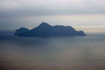
1) Did you see that Eagle Rock, supposedly somewhere along the cliff face. I thought it's somewhere along that track.
2) Very sad to hear of all the deal mutton birds. Maybe the following report on the Pacific ocean has some relation to it too.
http://www.smh.com.au/environment/the-o ... 2vs7v.html
1) Did you see that Eagle Rock, supposedly somewhere along the cliff face. I thought it's somewhere along that track.
2) Very sad to hear of all the deal mutton birds. Maybe the following report on the Pacific ocean has some relation to it too.
http://www.smh.com.au/environment/the-o ... 2vs7v.html
Just move it!
-
GPSGuided - Lagarostrobos franklinii
- Posts: 6801
- Joined: Mon 13 May, 2013 2:37 pm
- Location: Sydney
- Region: New South Wales
Re: The Coast Track, Otford to Bundeena - first solo overnig
![]() by Swampy460 » Sat 02 Nov, 2013 10:26 am
by Swampy460 » Sat 02 Nov, 2013 10:26 am
Great report and quite an extensive gear list, love the read and look forward to some photos. The wife and I plan to do this walk next year when it cools down a bit.
Swampy
Swampy
- Swampy460
- Atherosperma moschatum

- Posts: 69
- Joined: Mon 03 Sep, 2012 12:44 pm
- Region: New South Wales
- Gender: Male
Re: The Coast Track, Otford to Bundeena - first solo overnig
![]() by Onestepmore » Sat 02 Nov, 2013 11:15 am
by Onestepmore » Sat 02 Nov, 2013 11:15 am
Hi GPS - Eagle Rock is near Curracorong Creek, south of Watamolla (an hour I think?). I didn't actually note the formation that is said to look like an eagle, eye and all. I'll keep a better look out for it next time I go
We can learn a lot from crayons. They come in different shapes and colours, but they all have to live in the same box
-
Onestepmore - Athrotaxis selaginoides
- Posts: 1305
- Joined: Mon 02 Jul, 2012 11:33 am
- Location: Picton
- Region: New South Wales
- Gender: Female
Re: The Coast Track, Otford to Bundeena - first solo overnig
![]() by ULWalkingPhil » Sat 02 Nov, 2013 12:17 pm
by ULWalkingPhil » Sat 02 Nov, 2013 12:17 pm
Onestepmore wrote:Thanks guys! I tried to add some pics of the track and my tent and camp set up, but the site won't let me add them as it says the files are too big. I also tried to do it via my phone. I seem to remember in the past I have had to e-mail my pics to someone else and do it that way.
I really must read through the recommendations given to me when I had this problem last time, and download whatever program it is that I need to do this
So apologies, no photos! (maybe next week)
I agree about the Era campsite Phil. It's pretty messy, and it's a shame it's not more in the middle. There are no facilities provided at all, so it seems odd to place it there.
I think northern end of Garie beach would be better (about 9 km from the start), and provide a loo and bins that could more easily be emptied, as it seems that people are just going to dump rubbish anyway.
Or even better, expand on Wattamolla and have a camping area tucked away from the picnic site.
Totally agree. North Era is a stupid spot for a camp site on that walk. Who ever decided on that one, must have rocks in there head.
Email me your photos, I will downsize them for you and email them back. I just sent you a PM with my email address.
-
ULWalkingPhil - Lagarostrobos franklinii
- Posts: 2269
- Joined: Wed 05 Jan, 2011 2:14 pm
- Region: Queensland
Re: The Coast Track, Otford to Bundeena - first solo overnig
![]() by ULWalkingPhil » Sat 02 Nov, 2013 12:25 pm
by ULWalkingPhil » Sat 02 Nov, 2013 12:25 pm
Onestepmore wrote:Hi GPS - Eagle Rock is near Curracorong Creek, south of Watamolla (an hour I think?). I didn't actually note the formation that is said to look like an eagle, eye and all. I'll keep a better look out for it next time I go
Strange you missed out seeing that one, it stands out like a sore thumb, particularly on a clear day. The first time I completed the walk, I could hardly see it as it was covered in fog, but my last walk the weather was perfect. It's bizarre how nature has created such an specimen.
Mutton Birds, Love them, sorry to hear there was so many dead ones on the beach. I've been to islands during the hight of there breeding season. It's hard hat environment, they literally will knock you of your feet, the shear numbers is something to be seen. During the day you'r lucky to see them. As soon it's light they all leave for the day, They need a huge run up to fly and they all leave at once. Just on dark as sun goes down you see this large dark mass in the horizon, than it's time to take cover, they are very clumsy when they land. They make funny noises all night long and dig burrows in the sand. There also not scared of you, have no fear, you can walk right up to them and pat them, At least on the secluded islands I've been.
-
ULWalkingPhil - Lagarostrobos franklinii
- Posts: 2269
- Joined: Wed 05 Jan, 2011 2:14 pm
- Region: Queensland
Re: The Coast Track, Otford to Bundeena - first solo overnig
![]() by Lindsay » Sat 02 Nov, 2013 2:03 pm
by Lindsay » Sat 02 Nov, 2013 2:03 pm
Brilliant report OSM! How do you find the Mariposa with the bladder inside? I find it makes the usually comfortable pack feel a bit awkward and I do without it if I possibly can.
-

Lindsay - Phyllocladus aspleniifolius
- Posts: 680
- Joined: Thu 01 Oct, 2009 3:00 pm
- Location: Sydney
- Region: New South Wales
- Gender: Male
Re: The Coast Track, Otford to Bundeena - first solo overnig
![]() by ULWalkingPhil » Sat 02 Nov, 2013 3:21 pm
by ULWalkingPhil » Sat 02 Nov, 2013 3:21 pm
Double posted. Sorry
Last edited by ULWalkingPhil on Sat 02 Nov, 2013 3:23 pm, edited 1 time in total.
-
ULWalkingPhil - Lagarostrobos franklinii
- Posts: 2269
- Joined: Wed 05 Jan, 2011 2:14 pm
- Region: Queensland
Re: The Coast Track, Otford to Bundeena - first solo overnig
![]() by ULWalkingPhil » Sat 02 Nov, 2013 3:22 pm
by ULWalkingPhil » Sat 02 Nov, 2013 3:22 pm
ULWalkingPhil wrote:Lindsay wrote:Brilliant report OSM! How do you find the Mariposa with the bladder inside? I find it makes the usually comfortable pack feel a bit awkward and I do without it if I possibly can.
I know you directed this question to OSM, but I thought I should share my thoughts. I use a 3 litre bladder and fill it to 2L max. I found the comfort fine, never an issue for me. I now own two Gossamer Gear Packs, My new pack, a Kumo is my preferred pack. I don't use a bladder in it, choosing to use plastic bottles. The next time I use my Maripossa pack I will do the same, and see if I notice any difference without a bladder.
-
ULWalkingPhil - Lagarostrobos franklinii
- Posts: 2269
- Joined: Wed 05 Jan, 2011 2:14 pm
- Region: Queensland
Re: The Coast Track, Otford to Bundeena - first solo overnig
![]() by Bluegum Mic » Sat 02 Nov, 2013 7:25 pm
by Bluegum Mic » Sat 02 Nov, 2013 7:25 pm
Great report OSM. Sounds like a great trip. I was about to say email me your pics again but phil beat me to it 
Sent from my GT-I9505 using Tapatalk 2
Sent from my GT-I9505 using Tapatalk 2
-

Bluegum Mic - Athrotaxis selaginoides
- Posts: 1535
- Joined: Fri 08 Oct, 2010 10:24 am
- Region: New South Wales
- Gender: Female
Re: The Coast Track, Otford to Bundeena - first solo overnig
![]() by Lizzy » Sun 03 Nov, 2013 5:45 am
by Lizzy » Sun 03 Nov, 2013 5:45 am
Sounds like a great 1st solo overnighter for you (except the campground...). Can't believe they make you camp in that one spot with no toilet- for a popular walk that is just wrong. I did that walk about 20 years ago & we camped up near Eagle Rock- spectacular spot
Well done
Lizzy
Well done
Lizzy
-
Lizzy - Athrotaxis selaginoides
- Posts: 1055
- Joined: Mon 16 Nov, 2009 1:13 pm
- Region: New South Wales
- Gender: Female
Re: The Coast Track, Otford to Bundeena - first solo overnig
![]() by puredingo » Sun 03 Nov, 2013 8:46 am
by puredingo » Sun 03 Nov, 2013 8:46 am
Regarding the camp site at Era I think it was selected by the users before NP's nominated it as the "official" area to camp. Being naturally flat and cleared it was the logical place for surfers to camp up and wait for Era point to turn on. The place has changed remarkably since I was a kid and is testament to the impact mankind and feral animals has on heavily trodden areas like this. I personally would hate to see them open up Nth Garie beach to camping...it would only turn into a tip site like all these places that take little effort to get to.
Anyway unreal (and thorough!) trip report, glad you put a couple of bucks over the bar at the RSL, it keeps the place running....and my parents still live directly across the road so I need it to stay open ha!
Anyway unreal (and thorough!) trip report, glad you put a couple of bucks over the bar at the RSL, it keeps the place running....and my parents still live directly across the road so I need it to stay open ha!
- puredingo
- Athrotaxis selaginoides
- Posts: 1326
- Joined: Mon 13 Feb, 2012 6:54 am
- Region: New South Wales
Re: The Coast Track, Otford to Bundeena - first solo overnig
![]() by DaveNoble » Sun 03 Nov, 2013 2:38 pm
by DaveNoble » Sun 03 Nov, 2013 2:38 pm
I remember the campsite at North Era as being an excellent spot. But I have not camped there for many years - and certainly not since it has been designated as the "official campsite" of the Coastal Track. Back in the 70's and 80's (and of course earlier) it was a very popular campsite - and it was not uncommon to see several dozen tents there on a Saturday night. The best camping was way up the valley on nice grassy and shady flats. There was no toilet then - but there did not seem to be a problem with toilet waste (we used to go a long way into the scrub and did a hole....). Good water from the creek. I remember some big pythons that lived nearby. I remember the story of the headless body found on a lookout above.
The beach used to be owned by The Sydney Bushwalkers for a long time. They bought it during a conservation campaign - I think to prevent a hotel/resort going in (The Garrawarra Campaign). When the campaign was won (due to Myles Dunphy and others) - SBW sold the land (to NPWS?) and used the proceeds to buy land in Kangaroo Valley.
Other well used, popular campsites in Royal - along the Coastal Track were at Little Marley and Burning Palms - again both excellent spots.
I can remember some FBW Reunions at Era and Burning Palms - each with at least 100 walkers camping there.
Dave
- DaveNoble
- Athrotaxis selaginoides
- Posts: 1032
- Joined: Sun 03 Feb, 2008 3:56 pm
Re: The Coast Track, Otford to Bundeena - first solo overnig
![]() by portlester » Sun 03 Nov, 2013 3:04 pm
by portlester » Sun 03 Nov, 2013 3:04 pm
Thanks OSM
I'm planning on doing the Coast Track for the first time in about 15 years just before Christmas while visiting family in Sydney. What will make it even better is that it will be the first walk that my wife and I have done by ourselves in over a decade! As the kids have come along we moved from bushwalking to car camping to campertrailers - we have still been getting away from civilisation, but there is something special about doing it on two feet.
Your report has got the juices going and brought back many memories from my younger days when I used to spend alot of time exploring the RNP. In the 80's & early 90's (at least) camping was allowed at Curracurrang, Eagle Rock & Burning Palms, with campsites (although discouraged) also at Nth Era & Garie Beach.
I'm happy for authorities to limit camping to specific areas, however walks like this one (particularly with the use it gets & the fact that you pay to use it) should have a toilet & water tank facilities at the designated camp area. I also noted with interest that there is no mention of toilets (one way or the other) on the National Parks website for Nth Era campground (http://www.nationalparks.nsw.gov.au/royal-national-park/north-era-campground/camping) - maybe it gets a mention when you move into the booking section.
Thanks once again - you also have me thinking seriously about getting an alite monarch chair (or helinox one chair maybe). A big bloke who is unable to cross his legs while sitting, does not always make for a comfortable trip.
- portlester
- Nothofagus gunnii

- Posts: 35
- Joined: Fri 28 Dec, 2012 10:37 am
- Location: Geelong
- Region: Victoria
- Gender: Male
Re: The Coast Track, Otford to Bundeena - first solo overnig
![]() by Onestepmore » Sun 03 Nov, 2013 6:24 pm
by Onestepmore » Sun 03 Nov, 2013 6:24 pm
Hi Portlester
If youre a big boy with stiff legs the Helinox One Chair may be a better choice, as the Monarch is pretty low down. Have a look at a post I made in 'Equipment' in the Hiking Chair thread - you may find the podcast from The Outdoors Station at the end useful to help you decide.
If you look at the national parks link you give above for North Era campsite (which I checked during my planning), and click on 'Important Info' with the arrow, the third line down says 'Toilets: Non-flushing"
I wish they woud update their sites
When I went to the Watagans recenly, to the northern Cat Creek campsites, they listed toilets, water tanks and gas BBQ's as facilities offered. Well, a tree had fallen on the toilet block and crushed it, there were no tapsheads for the tanks, and neither of the BBQ's worked. I now just assume that anything they list may not exist. So different from NZ campsites and walking trails, where they actually try and provide walkers with amenities to make their eperience more enjoyable.
And thanks for the additional background information Dave and Puredingo - interesting
Lindsey - I haven't noticed anything odd with the feel of a hydration pack in the Mariposa. When it's on the ground it does look to bulge disconcertingly at the back, due to the back support just being the foam eggshell pad and no stiff stays etc, but I've not had a problem. I use a 2L size hydation pack - maybe a 3L would be different? I'll have to try it without a bladder and see if it's any different. I do get sweaty on my back with this pack, more than I do with my Aarn (but I tend to use that in cooler temps and bigger loads), and the Osprey packs with the mesh that provide airflow between pack and back. I think the concept of the new Macpac Tasman 45 (here's a review http://lotsafreshair.com/) where the bladder swings free in the gap between the harness system of the pack and your back seems good (but I don't need to buy another pack!)
Last edited by Onestepmore on Sun 03 Nov, 2013 6:34 pm, edited 1 time in total.
We can learn a lot from crayons. They come in different shapes and colours, but they all have to live in the same box
-
Onestepmore - Athrotaxis selaginoides
- Posts: 1305
- Joined: Mon 02 Jul, 2012 11:33 am
- Location: Picton
- Region: New South Wales
- Gender: Female
Re: The Coast Track, Otford to Bundeena - first solo overnig
![]() by Allchin09 » Sun 03 Nov, 2013 6:28 pm
by Allchin09 » Sun 03 Nov, 2013 6:28 pm
Hi OSM,
I am going to a meeting this Thursday where a few rangers from the RNP will be present. If want I would be more than happy to pass on to them your comments regarding the site, the toilet and the state of the track. If so, is there anything else that you would like me to mention?
If anyone else has comments, just let me know.
Tackling the unknown and the awesome one adventure at a time!
Try www.bushwalkingmaps.com
Try www.bushwalkingmaps.com
- Allchin09
- Phyllocladus aspleniifolius
- Posts: 715
- Joined: Fri 27 Apr, 2012 3:24 pm
- ASSOCIATED ORGANISATIONS: Sydney Bush Walkers
- Region: New South Wales
- Gender: Male
Re: The Coast Track, Otford to Bundeena - first solo overnig
![]() by Onestepmore » Sun 03 Nov, 2013 6:37 pm
by Onestepmore » Sun 03 Nov, 2013 6:37 pm
Great - yeah for sure mention that for one of the more promoted NSW tracks, and a heavily used one, it coulld do with some TLC!
And to update their information sites - many people use them as their first point of reference when deciding on an outing
Thanks - let us know what their response is
And to update their information sites - many people use them as their first point of reference when deciding on an outing
Thanks - let us know what their response is
We can learn a lot from crayons. They come in different shapes and colours, but they all have to live in the same box
-
Onestepmore - Athrotaxis selaginoides
- Posts: 1305
- Joined: Mon 02 Jul, 2012 11:33 am
- Location: Picton
- Region: New South Wales
- Gender: Female
Re: The Coast Track, Otford to Bundeena - first solo overnig
![]() by Allchin09 » Sun 03 Nov, 2013 6:55 pm
by Allchin09 » Sun 03 Nov, 2013 6:55 pm
Cool, will do. I believe that there are plans for major upgrades in the near future, and a 'Strategic Management Framework summary report' has been prepared - http://friendsofroyal.org.au/wp-content ... e-2013.pdf
I guess the funding is what is holding the major upgrade back.
I guess the funding is what is holding the major upgrade back.
Tackling the unknown and the awesome one adventure at a time!
Try www.bushwalkingmaps.com
Try www.bushwalkingmaps.com
- Allchin09
- Phyllocladus aspleniifolius
- Posts: 715
- Joined: Fri 27 Apr, 2012 3:24 pm
- ASSOCIATED ORGANISATIONS: Sydney Bush Walkers
- Region: New South Wales
- Gender: Male
Re: The Coast Track, Otford to Bundeena - first solo overnig
![]() by Onestepmore » Sun 03 Nov, 2013 7:07 pm
by Onestepmore » Sun 03 Nov, 2013 7:07 pm
Probably.
Being one of the 'premier' bushwalks in the state due to it's being so close to Sydney, the historical aspect of the RNP, it being accessible by public transport, and having some great varied and very beautiful scenery, it would be lovely if it could be upgraded to become a showpiece walk, the Jewel In The Crown. Doing this would make it more attractive to tourists and even overseas hikers, which of course adds to the local economy.
if they provided some facilities, maybe (shock horror) they could increase their overnight fee to $15?
Edite I just read that document - it's very comprehensive and has some great observations and recommendations
Thanks for linking it
We can learn a lot from crayons. They come in different shapes and colours, but they all have to live in the same box
-
Onestepmore - Athrotaxis selaginoides
- Posts: 1305
- Joined: Mon 02 Jul, 2012 11:33 am
- Location: Picton
- Region: New South Wales
- Gender: Female
Re: The Coast Track, Otford to Bundeena - first solo overnig
![]() by Rob Gosford » Mon 04 Nov, 2013 8:04 am
by Rob Gosford » Mon 04 Nov, 2013 8:04 am
Onestepmore wrote:I didn't actually note the formation that is said to look like an eagle, eye and all. I'll keep a better look out for it next time I go
what a great report OSM ! have neverrr been to the RNP, would love to one day. I followed your trip report on Google Earth and spotted this photo of Eagle Rock (part of the rock that juts out on the top right) ........
http://www.panoramio.com/photo/47759276?source=wapi&referrer=kh.google.com
the "eye" is visible too !
-

Rob Gosford - Athrotaxis cupressoides

- Posts: 185
- Joined: Mon 24 Sep, 2012 7:27 am
- Location: Kariong, Central Coast
- Region: New South Wales
- Gender: Male
Re: The Coast Track, Otford to Bundeena - first solo overnig
![]() by Onestepmore » Mon 04 Nov, 2013 8:31 am
by Onestepmore » Mon 04 Nov, 2013 8:31 am
How on earth did I miss that? 
We can learn a lot from crayons. They come in different shapes and colours, but they all have to live in the same box
-
Onestepmore - Athrotaxis selaginoides
- Posts: 1305
- Joined: Mon 02 Jul, 2012 11:33 am
- Location: Picton
- Region: New South Wales
- Gender: Female
Re: The Coast Track, Otford to Bundeena - first solo overnig
![]() by GPSGuided » Mon 04 Nov, 2013 9:16 am
by GPSGuided » Mon 04 Nov, 2013 9:16 am
Has the eagle lost a bit of its beak over the years?
Just move it!
-
GPSGuided - Lagarostrobos franklinii
- Posts: 6801
- Joined: Mon 13 May, 2013 2:37 pm
- Location: Sydney
- Region: New South Wales
Re: The Coast Track, Otford to Bundeena - first solo overnig
![]() by DarrenM » Mon 04 Nov, 2013 2:42 pm
by DarrenM » Mon 04 Nov, 2013 2:42 pm
Congrats on your first solo overnight trip! Great read.
- DarrenM
- Athrotaxis cupressoides
- Posts: 465
- Joined: Tue 19 Oct, 2010 7:10 pm
- Location: Sydney
- Region: New South Wales
- Gender: Male
Re: The Coast Track, Otford to Bundeena - first solo overnig
![]() by Rob Gosford » Mon 04 Nov, 2013 9:01 pm
by Rob Gosford » Mon 04 Nov, 2013 9:01 pm
Onestepmore wrote:How on earth did I miss that?
that is an amazing piece of rockscape OSM......it really does look like an eagle
here is some rock i photographed on the GNW last year in the Sugarloaf Range just north of Heaton Gap....
i call it "the rockface"
.
-
Rob Gosford - Athrotaxis cupressoides
- Posts: 185
- Joined: Mon 24 Sep, 2012 7:27 am
- Location: Kariong, Central Coast
- Region: New South Wales
- Gender: Male
Re: The Coast Track, Otford to Bundeena - first solo overnig
![]() by GPSGuided » Mon 04 Nov, 2013 9:10 pm
by GPSGuided » Mon 04 Nov, 2013 9:10 pm
Didn't know we have a Mo'ai too!
Just move it!
-
GPSGuided - Lagarostrobos franklinii
- Posts: 6801
- Joined: Mon 13 May, 2013 2:37 pm
- Location: Sydney
- Region: New South Wales
49 posts
• Page 1 of 2 • 1, 2
Return to NSW & ACT Trip Reports & Track Notes
Who is online
Users browsing this forum: No registered users and 0 guests