We made it to Mt Ramsay on Monday. After walking a different route in and out there doesn't seem to be an 'easy' way to the summit from the 4WD track, although our southern route was a little better than the northern. The northern approach was initially under lovely myrtle forest up to the top of the NE hill but on the steep western side this soon changed to very large boulders with scrub between.

We saw a number of pink tapes and some evidence of track work across the top of the hill but these were nowhere in evidence further on and closer to the summit. The boulders and scrub continued on the ridge heading south towards to the summit.
Not wanting to return the same way, we decided to head for one of the old roads on the southern side of the NE hill. After dropping off the side of Ramsay the bauera became very thick but eventually gave way to forest which was easier despite the countless fallen logs and horizontal. It took some scouting around but we eventually found the old road which connected to the main 4WD track, where there was another pink tape marking the turn off. Overall we found it very slow going when off track. Hats off to my walking companion who is more than 20 years my senior. We camped about 2 hours walk along the 4WD track and it took us 10 hours return from there.


(Ignore the part where the GPS plot veers to the east of the main 4WD track, my GPS went haywire for a while then).

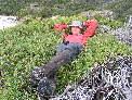
Mt Ramsay summit with Mt Cleveland in the distance