When you walk the Three Capes Track you hear the word “experience” a lot.
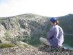
Standing on top of the Blade at Cape Pillar is a remarkable experience. A grandstand view to Tasman Island, the other capes on the horizon, and if you dare look down on two sides cliffs plummet hundreds of metres to the ocean below. When the wind picks up it is even more exciting. But there is more to it than the Blade.
The Three Capes Track is like an easily digestible sample bag of Tasmanian national parks: white sandy beaches, huge majestic cliffs, and some stunning rainforest with giant ferns. All this with lighter packs (sans tent, mattress, and stove) and none of Tasmania’s famous mud.
My wife and I planned a few weeks of walking in Tasmania in Autumn 2016. We intended to explore the Tasman Peninsula with day walks. My wife entered a 25 words or less competition to win a ticket to the Three Capes Track. It was agreed that if she won I would buy a $495 ticket to accompany her. She won! This was to be my wife’s second ever overnight walk. The first was a two-night walk, sleeping in a tent in the alpine Walls of Jerusalem National Park.
The Three Cape Track is a 46 kilometre walk over four-days and three-nights. A maximum of 48 walkers commence each day walk. The journey begins with a short cruise. Walkers stay at each of the three huts for one night: Surveyors (night 1), Munro (Night 2) and Retakunna (Night 3). The walk ends at Fortescue Bay with a bus trip back to the beginning of the walk.
Day 1 – The elusive cape
Our journey began at Port Arthur where I received my Three Capes Track pack tag; hearsay evidence that I was the 3471st odd walker since the track opened in December 2015. All walkers also receive an 88 page Encounters on the Edge guidebook.
Soon we were aboard the boat cruising alongside cliffs near Port Arthur with about half of the walkers with whom we would share the next few days. The other walkers had taken the earlier cruise. The jocular captain spoke engagingly about the geology, birdlife and local history of the area. After passing Safety Cove, the boat paused whilst we admired the huge steep sand dunes rising from the stunning Crescent Bay. Then the boat set out towards the first cape. It was our first glimpse of Cape Raoul, over five kilometres away to the West. And that was as close as we would get to it. Our captain referred to it as “the elusive cape”.
The boat picked up speed. It headed for the other side of Port Arthur and entered Denmans Cove. We disembarked onto sand. Our feet remained dry. Most of the other walkers rushed off. There was no need to rush. Day 1 is a mere 4 kilometres of easy walking to Surveyors Hut. The highlight is Denman’s Cove. It is a narrow cove with a superb white sandy beach. If the weather is good, it is worth sticking around for while. I wish we had.
Stepping off the beach at Denmans Cove an elaborate sign marks the start of the track. After a few strides we joined the line for the boot cleaning station. Its aim is to stop the spread of Phytophthora (root rot). With clean books we hiked through costal heathland and eucalypt woodland (so the guidebook tells us). The track is over a metre wide and conducive to conversation. It is designed so that two walkers with packs can walk side by side. There is seldom need to look down. A wide track has come at a cost. In parts over three metres of vegetation have been cleared to construct the path. This brings a sense of distance between the walker and environment. Displaced trees and shrubs are cast to the side of the track. In time the surrounding vegetation will fill some of this space.
After a couple of hours walking we rested at Surveyors Cove. From this rocky cove it was a short stroll uphill to complete Day 1. Before we could see the first hut we noticed significant land has been cleared or burnt (a necessary part of the bushfire safety strategy we were told). For the very last stretch a boardwalk led us to Surveyors Hut. As we approached the ranger welcomed us and showed us to our dorm. On all three nights of the walk we shared a four-person room with two friendly university students from Sydney.
To call Surveyors a hut is misleading. It is really a series of impressively designed wooden buildings all connected by decking and boardwalks. Two large sleeping huts (each with a number of separate rooms sleeping four or eight on bunks) sit in a line along with two kitchen huts. The kitchen huts have cooking facilities (commercial gas cookers and stainless steel saucepans, utensils and kettles). Inside these huts are dining areas with stainless steel tables, benches and designer chairs. Behind the line of main huts is the toilet block, rangers hut and helipad; all connected by boardwalk.
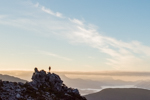
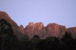
As evening approached the ranger gathered all 48 of the walkers and gave us a “briefing”. He pointed out a Bennetts wallaby lurking nearby (one of the few marsupials we would see on the walk) and told where we had been, where we were going, and about the facilities (including library, board games, yoga mats, foam rollers and deck chairs). We cooked our tea in the kitchen. As the sun was about to set it we headed outside to the large deck at the end of the line of huts. It felt like we were on the top deck of a cruise ship. Straight ahead, through the cleared vegetation, was a stunning view of Cape Raoul: the elusive cape.
Three Capes Track – Trip Report (March - April 2016)
Forum rules
Posting large/multiple images in this forum is OK. Please start topic titles with the name of the location or track.
For topics focussed on photos rather than the trip, please consider posting in the 'Gallery' forum instead.
This forum is for posting information about trips you have done, not for requesting information about a track or area.
32 posts
• Page 1 of 2 • 1, 2
Three Capes Track – Trip Report (March - April 2016)
![]() by beardless » Tue 24 May, 2016 12:44 am
by beardless » Tue 24 May, 2016 12:44 am
- Attachments
-
- Port Arthur Historic Site
-
- Cruise - sea caves
-
- Crescent Bay
-
- Denmans Cove
-
- Start of the Track - Denmans Cove
-
- Boardwalk approaching Surveyors Hut
-
- Deck at Surveyors Hut – view to the elusive Cape
-
- View from Surveyors – kitchen
-
- Surveyors at Dusk
Last edited by beardless on Wed 25 May, 2016 10:52 pm, edited 1 time in total.
-
beardless - Phyllocladus aspleniifolius

- Posts: 513
- Joined: Fri 05 Jul, 2013 8:56 pm
- Region: South Australia
- Gender: Male
Re: Three Capes Track – Trip Report (March - April 2016)
![]() by beardless » Tue 24 May, 2016 12:52 am
by beardless » Tue 24 May, 2016 12:52 am
Day 2 – The best hut
The ranger kindly took our photograph as we left towards Munro Hut. We wondered if Munro would provide as impressive views as Surveyors. After 11 more kilometres, and 4.5 hours walking, we would find out.
Thirty-six artistic “encounters” are spaced along the Three Capes Track. Often these provide a seat to rest and are located near stunning views. All encounters are linked to information and stories about flora, fauna, and history in the guidebook. Soon after leaving Surveyors are a group of large wooden cubes entitled “Who was here?”. Their shape evidently references the shape of wombat scat. A later encounter on Day 2 is a small mosaic set into the track, an artistic reflection of some of the colourful local fungi. Others are much less unobtrusive such as the large bright orange metal sculpture (seat) on route to Cape Pillar. It detracts significantly from the natural beauty of the landscape. It would look more at home in a primary school playground (although its title would not). If the creators wanted a talking point, they succeeded.
Soon after passing the wombat scat seats the track climbs steadily to Arthurs Peak (312 metres above sea level). From here there are spectacular views across Port Arthur to Cresent Bay and beyond that to Cape Raoul. The remaining track to Munro Hut is relatively flat. Initially it hugs the cliffs before heading inland. About two thirds of the way to Munro is a four way track junction. Even though the maps in the guidebook are relatively rudimentary, it is almost impossible to get lost on the Three Capes Track. The signs are clear. At the junction to the left is the inbound track from Fortescue Bay. Straight ahead is the track to Retakunna Hut (night 3). We turned right towards Munro Hut (night 2) an hours walk from the junction though denser taller forest. Part way along there is a track to the left (it heads to the Wughalee Falls, the only official camp site for independent, tent carrying, walkers). Later on, another track leads off to the right (which I was told is a remnant of the old Cape Pillar Track which bypasses Munro Hut). Not long after, the Munro Hut complex emerged. To the right is the kitchen hut and beyond that the sleeping huts. To the left, a long dramatic deck perched on the edge of the cliff top with amazingly spectacular views of the cliffs all the way to Cape Hauy. The views top those from Surveyors. With these views Munro is the best hut.
That was the official end of walking for Day 2. I recommend bringing some reading material for the second day. For us the weather was perfect and we had about six hours left until sunset. The ranger spoke of potential rain for Day 3. Seizing the day we unpacked, ate lunch, and headed off with a daypack for a further 13 kilometre return trip towards the Blade (which is normally the feature of Day 3). The first few kilometres are fairly bland. It was quick walking. After a number of kilometres you reach a boardwalk stretching for hundreds of metres. The following day I suggested to two older seasoned fellow walkers that if you blur your eyes it looks like the Great Wall of China. They nodded and said they had named it the “Great Boardwalk of Tasmania”.
Much of the Great Boardwalk of Tasmania has handrails, presumably to protect walkers from the 1-2 drop off the side. In a fascinating contrast, a little further on the cliffs are left largely untamed. For a few kilometres the track follows the cliff tops often metres away from the edge of some of the highest sea cliffs in the Southern Hemisphere. As the guidebook says:
“This is an edgy walk – and we take you near that edge, many times. We also trust you near the edge. There are no fences … Beyond the track in some places it is a sheer vertical drop to the sea, hunderds of metres below. If you are travelling with children, keep them close.”
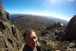
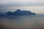
These few kilometres of track to the Blade are utterly spectacular. The Blade is marketed as the highlight of the walk. It does not disappoint. The track builders have constructed a narrow stone staircase that winds the way up to the top where two cliffs merge. At the top, we climbed a flat-topped rock with large drops on two sides, and a view along the Blade to Tasman Island. It was exhilarating.
We retraced our steps back to Munro arriving after the ranger’s briefing. Munro is the only hut with a shower. After 24 kilometres of walking we needed it. We used about half a bucket each. It is easy to be conservative when the water is cold.
The library in each hut is identical. The idea is you can start a book at one hut and continue it later in the walk. After tea at Munro, I continued reading A Field Guide to Tasmanian Fungi and another book containing some fascinating history of the lighthouse keeper families on Tasman Island. We would return to view Tasman Island and its lighthouse again the next day.
The ranger kindly took our photograph as we left towards Munro Hut. We wondered if Munro would provide as impressive views as Surveyors. After 11 more kilometres, and 4.5 hours walking, we would find out.
Thirty-six artistic “encounters” are spaced along the Three Capes Track. Often these provide a seat to rest and are located near stunning views. All encounters are linked to information and stories about flora, fauna, and history in the guidebook. Soon after leaving Surveyors are a group of large wooden cubes entitled “Who was here?”. Their shape evidently references the shape of wombat scat. A later encounter on Day 2 is a small mosaic set into the track, an artistic reflection of some of the colourful local fungi. Others are much less unobtrusive such as the large bright orange metal sculpture (seat) on route to Cape Pillar. It detracts significantly from the natural beauty of the landscape. It would look more at home in a primary school playground (although its title would not). If the creators wanted a talking point, they succeeded.
Soon after passing the wombat scat seats the track climbs steadily to Arthurs Peak (312 metres above sea level). From here there are spectacular views across Port Arthur to Cresent Bay and beyond that to Cape Raoul. The remaining track to Munro Hut is relatively flat. Initially it hugs the cliffs before heading inland. About two thirds of the way to Munro is a four way track junction. Even though the maps in the guidebook are relatively rudimentary, it is almost impossible to get lost on the Three Capes Track. The signs are clear. At the junction to the left is the inbound track from Fortescue Bay. Straight ahead is the track to Retakunna Hut (night 3). We turned right towards Munro Hut (night 2) an hours walk from the junction though denser taller forest. Part way along there is a track to the left (it heads to the Wughalee Falls, the only official camp site for independent, tent carrying, walkers). Later on, another track leads off to the right (which I was told is a remnant of the old Cape Pillar Track which bypasses Munro Hut). Not long after, the Munro Hut complex emerged. To the right is the kitchen hut and beyond that the sleeping huts. To the left, a long dramatic deck perched on the edge of the cliff top with amazingly spectacular views of the cliffs all the way to Cape Hauy. The views top those from Surveyors. With these views Munro is the best hut.
That was the official end of walking for Day 2. I recommend bringing some reading material for the second day. For us the weather was perfect and we had about six hours left until sunset. The ranger spoke of potential rain for Day 3. Seizing the day we unpacked, ate lunch, and headed off with a daypack for a further 13 kilometre return trip towards the Blade (which is normally the feature of Day 3). The first few kilometres are fairly bland. It was quick walking. After a number of kilometres you reach a boardwalk stretching for hundreds of metres. The following day I suggested to two older seasoned fellow walkers that if you blur your eyes it looks like the Great Wall of China. They nodded and said they had named it the “Great Boardwalk of Tasmania”.
Much of the Great Boardwalk of Tasmania has handrails, presumably to protect walkers from the 1-2 drop off the side. In a fascinating contrast, a little further on the cliffs are left largely untamed. For a few kilometres the track follows the cliff tops often metres away from the edge of some of the highest sea cliffs in the Southern Hemisphere. As the guidebook says:
“This is an edgy walk – and we take you near that edge, many times. We also trust you near the edge. There are no fences … Beyond the track in some places it is a sheer vertical drop to the sea, hunderds of metres below. If you are travelling with children, keep them close.”
These few kilometres of track to the Blade are utterly spectacular. The Blade is marketed as the highlight of the walk. It does not disappoint. The track builders have constructed a narrow stone staircase that winds the way up to the top where two cliffs merge. At the top, we climbed a flat-topped rock with large drops on two sides, and a view along the Blade to Tasman Island. It was exhilarating.
We retraced our steps back to Munro arriving after the ranger’s briefing. Munro is the only hut with a shower. After 24 kilometres of walking we needed it. We used about half a bucket each. It is easy to be conservative when the water is cold.
The library in each hut is identical. The idea is you can start a book at one hut and continue it later in the walk. After tea at Munro, I continued reading A Field Guide to Tasmanian Fungi and another book containing some fascinating history of the lighthouse keeper families on Tasman Island. We would return to view Tasman Island and its lighthouse again the next day.
- Attachments
-
- "Who Was Here?" - Wombat Scat Seat
-
- View across Port Arthur to Crescent Bay
-
- Arthurs Peak
-
- The Track
-
- Seat (or potential tent platform)
-
- Boardwalk
-
- Munro – the best hut
-
- Deck at Munro
-
- Massive Cliffs looking towards Resolution Point
-
- The Blade and Tasman Island
-
beardless - Phyllocladus aspleniifolius
- Posts: 513
- Joined: Fri 05 Jul, 2013 8:56 pm
- Region: South Australia
- Gender: Male
Re: Three Capes Track – Trip Report (March - April 2016)
![]() by beardless » Tue 24 May, 2016 12:55 am
by beardless » Tue 24 May, 2016 12:55 am
The Blade
- Attachments
-
- On top of the Blade
-
- Standing on the Blade
-
- The block on the Blade
-
- View from the Blade
-
- The Great Boardwalk of Tasmania
-
beardless - Phyllocladus aspleniifolius
- Posts: 513
- Joined: Fri 05 Jul, 2013 8:56 pm
- Region: South Australia
- Gender: Male
Re: Three Capes Track – Trip Report (March - April 2016)
![]() by beardless » Tue 24 May, 2016 1:03 am
by beardless » Tue 24 May, 2016 1:03 am
Day 3 – Cathedral Rock Side trip & back to the Blade
Early on Day 3 the morning light lit up the cliffs across Munro Bight to Cape Hauy.
The official walk on Day 3 is to the Blade. Most of the other walkers left before us. Our fellow walkers were all friendly. There were a few travellers from overseas, solo walkers, and a number of families (one family of five with three teenagers, and another very fit family with three teenagers and grandparents who seemed over seventy). There were university students, and a group of six adults walking together. Two older seasoned walkers told us that the huts on the Three Capes Track were similar to some on the New Zealand Great Walks, but even better.
Having been to the Blade the day before we took the morning slowly. I asked the ranger about side trips. He said that unlike the Overland Track (where side tracks to mountains and waterfalls are a feature) there are no official side trips on the Three Capes Track. He mentioned a couple of options. The typographical map of Tasman Peninsula on the wall in the hut showed a side trip to Chasm Lookout at the end of Cape Pillar. So again we walked towards the Blade, along the Great Boardwalk of Tasmania. Again I photographed the amazing cliffs and the Trident (a three-pronged rock emerging from the ocean). Along the way we noticed a number of old campsites (Oasis Camp and Blade Camp) that had been covered with vegetation cleared during the track construction. The guidebook contains extracts from Tim Christie’s 1970 article in the Tasmanian Tramp about the history of conquering Cathedral Rock.
Just before the main track ascends for the final climb to the top of the Blade a track leads off to the left (from memory a sign with an arrow says “track”). Initially the walking is easy. After a short distance there is lookout to view the Blade and Tasman Island. The track continues through a low forest, before it is necessary to scramble up rock a number of times. My wife bravely led the way. The track continued on the edge of cliffs around the Chasm. Here cliffs on both sides frame the ocean below. After more scrambling we reached the end of the track. From here Cathedral Rock rose from the ocean below. We returned carefully to the main track. The side trip felt like real bushwalking. All up it took us a couple of hours (but we were going slowly).
Back at the main track we walked up to the top of the Blade for lunch. We again had it to ourselves (as our fellow walkers had returned to the hut). This time there was more wind, which made standing on the block of rock at the top feel more precarious. We walked back to Munro. I noticed walking on the gravel and boardwalk of new Three Capes Track was significantly louder compared to the side trip track. Perhaps that is why we saw so few animals on the walk.
We picked up our main packs at the shed, walked back through Munro, towards the four-way track junction (we were too tired to explore Wughalee Falls). At the four-way junction we turned right towards Retakunna for our final night. All up the official walking for day three is the longest (17km). We added at least two more with the side trip.
Retakunna is set in typical Australian bushland and has all the facilities of the other huts (but a less dramatic view). We arrived in time for the ranger’s briefing. He told informed us about the original plan to make the Three Capes Track a six-day (five-night) walk. He said this is unlikely to occur soon. For the foreseeable future, there will remain an elusive cape. He also spoke about conservation of the Tasman Peninsula. Discussing threats of introduced species like foxes and cats he said: “In Australia, you can love either native wildlife or cats, but you can’t love both”. As for wildlife, he said walkers often see a local wombat around Retakunna at night. We did not.
We had amazing weather for the walk. When there are no clouds from all three huts the night sky was spectacular. At Retakunna it rained during the night. It did not matter, the huts kept us warm and dry.
- Attachments
-
- Morning Light on Munro Bight
-
- View from Munro Hut
-
- Sculpture titled “Sex on the Cape”
-
- Warning sign
-
- On the Edge - Three Capes Track
-
- The Trident, the Blade and Tasman Island
-
- The Blade and Tasman Island (from the side track)
-
- The Chasm
-
- Cathedral Rock
-
- Massive cliffs near the Chasm
Last edited by beardless on Wed 25 May, 2016 10:55 pm, edited 2 times in total.
-
beardless - Phyllocladus aspleniifolius
- Posts: 513
- Joined: Fri 05 Jul, 2013 8:56 pm
- Region: South Australia
- Gender: Male
Re: Three Capes Track – Trip Report (March - April 2016)
![]() by beardless » Tue 24 May, 2016 1:07 am
by beardless » Tue 24 May, 2016 1:07 am
The Chasm
- Attachments
-
- View to Munro Bight from the Chasm
-
- The Blade on the way back from the Chasm
-
- Inside sleeping hut – Retakunna
-
- View from Retakunna hut
-
- Retakunna hut at night
-
beardless - Phyllocladus aspleniifolius
- Posts: 513
- Joined: Fri 05 Jul, 2013 8:56 pm
- Region: South Australia
- Gender: Male
Re: Three Capes Track – Trip Report (March - April 2016)
![]() by beardless » Tue 24 May, 2016 1:14 am
by beardless » Tue 24 May, 2016 1:14 am
Day 4 – The day which has it all
Day 4 is a 14 kilometres walk. It has it all: a mountain, rainforest, massive cliffs and a beautiful beach.
After a few hundred metres the track begins to climb up Mt Fortescue (482 metres). It is a delightful walk through rainforest, with tall trees, ferns and all kinds of colourful fungi. Reaching the top there are magnificent views back towards Cape Pillar. Descending Mt Fortescue the rainforest continues with huge ferns. This stretch was an unanticipated highlight of the walk. Unfortunately, we had booked the early bus back so we were on a tight schedule. There was not time to dwell for too long. After the descent, the track follows the cliff tops before heading inland. Soon after is a junction where we dropped our main packs.
From the junction, the track to Cape Hauy is fairly steep. There are hundreds of steps down and then up to the Cape. My wife was tiring from the two previous days (which included our extra trip to the Blade on Day 2 and the extra side trip to the Chasm on Day 3). On the way we met the family with the fit seventy year olds who (already on the way back) offered encouraging words. With their encouragement we made it. Cape Hauy is also spectacular. But we had no time to linger. We headed back to the junction, picked up our packs and from there it is a fairly unremarkable walk until we reached Fortescue Bay. This white sandy beach was a splendid finale. Some of our fellow walkers who arrived before us had a swim. We only had time to wet our feet before it was time to catch the bus back to Port Arthur and end our Three Capes Track experience.
- Attachments
-
- Boardwalk walking towards Mt Fortescue
-
- Fungi walking up Mt Fortescue
-
- Stunning views from Mt Fortescue
-
- Rainforest descending Mt Fortescue
-
- Coral Fungi
-
- Views to Cape Pillar
-
- Track to Cape Hauy
-
- Cape Hauy
-
- The way Back from Cape Hauy
-
- Fortescue Bay
Last edited by beardless on Wed 25 May, 2016 10:59 pm, edited 1 time in total.
-
beardless - Phyllocladus aspleniifolius
- Posts: 513
- Joined: Fri 05 Jul, 2013 8:56 pm
- Region: South Australia
- Gender: Male
Re: Three Capes Track – Trip Report (March - April 2016)
![]() by beardless » Tue 24 May, 2016 1:17 am
by beardless » Tue 24 May, 2016 1:17 am
Fortescue Bay
- Attachments
-
- Fortescue Bay
-
- Beach at Fortescue Bay
-
beardless - Phyllocladus aspleniifolius
- Posts: 513
- Joined: Fri 05 Jul, 2013 8:56 pm
- Region: South Australia
- Gender: Male
Re: Three Capes Track – Trip Report (March - April 2016)
![]() by beardless » Tue 24 May, 2016 1:20 am
by beardless » Tue 24 May, 2016 1:20 am
Summary of the experience
In bushwalking terms it was luxurious. The huts drew unanimous praise from our fellow walkers. They really are such a feature of this walk. Perhaps it could be renamed the Three Huts Track. The walk would be great for people trying overnight walking. It would be excellent for families with teenagers or as a social walk with a group of friends. It will enable some older people to continue extended walks for longer. It is communal. So if you are looking for solitude, it is best to look elsewhere. The price will also be prohibitive for many.
The Three Capes track exceeded expectations. All in all, despite all the controversy, I thought it was a really enjoyable walk. My wife thought so too. Interestingly, she preferred the trip to Walls of Jerusalem National Park despite that walk being more difficult, involving a heavier pack, and sleeping in a small tent (including one night where it rained). There is something special about being in the middle of untamed Tasmanian wilderness.
Last edited by beardless on Wed 25 May, 2016 11:01 pm, edited 1 time in total.
-
beardless - Phyllocladus aspleniifolius
- Posts: 513
- Joined: Fri 05 Jul, 2013 8:56 pm
- Region: South Australia
- Gender: Male
Re: Three Capes Track – Trip Report (March - April 2016)
![]() by beardless » Tue 24 May, 2016 1:37 am
by beardless » Tue 24 May, 2016 1:37 am
The End.
-
beardless - Phyllocladus aspleniifolius
- Posts: 513
- Joined: Fri 05 Jul, 2013 8:56 pm
- Region: South Australia
- Gender: Male
Re: Three Capes Track – Trip Report (March - April 2016)
![]() by bumpingbill » Tue 24 May, 2016 10:26 am
by bumpingbill » Tue 24 May, 2016 10:26 am
Great write up. I've been waiting (almost begging) for a review like this. It's detailed, it's got great photos, it really gets across the sense of mood/feeling of the walk too - so thank you very very much.
EDIT: This is the type of review that the press should have done when it first opened.
EDIT: This is the type of review that the press should have done when it first opened.
-

bumpingbill - Athrotaxis cupressoides

- Posts: 250
- Joined: Tue 19 Feb, 2013 7:48 am
- Region: Tasmania
Re: Three Capes Track – Trip Report (March - April 2016)
![]() by Mountain Rocket » Tue 24 May, 2016 10:37 am
by Mountain Rocket » Tue 24 May, 2016 10:37 am
Great trip report, thanks for sharing it!
As you say there is something special about untamed wilderness... but from all the photos 'the great boardwalk of Tas' just doesn't fit that criteria.
I'll have to get out there some time and make up my own mind but so far I still remain sceptical.
As you say there is something special about untamed wilderness... but from all the photos 'the great boardwalk of Tas' just doesn't fit that criteria.
I'll have to get out there some time and make up my own mind but so far I still remain sceptical.
-
Mountain Rocket - Phyllocladus aspleniifolius
- Posts: 849
- Joined: Sat 27 Aug, 2011 5:46 pm
- Region: Tasmania
- Gender: Male
Re: Three Capes Track – Trip Report (March - April 2016)
![]() by north-north-west » Tue 24 May, 2016 10:47 am
by north-north-west » Tue 24 May, 2016 10:47 am
The Great Boardwalk of Tasmania'. I like that. Has a certain ring to it. And at least it's more accurate than 'Three Capes'.
"Mit der Dummheit kämpfen Götter selbst vergebens."
-

north-north-west - Lagarostrobos franklinii

- Posts: 15493
- Joined: Thu 14 May, 2009 7:36 pm
- Location: The Asylum
- ASSOCIATED ORGANISATIONS: Social Misfits Anonymous
- Region: Tasmania
Re: Three Capes Track – Trip Report (March - April 2016)
![]() by beardless » Tue 24 May, 2016 10:56 am
by beardless » Tue 24 May, 2016 10:56 am
Thanks for the feedback. I hoped it would provide a useful perspective on the walk. To be clear the words untamed wilderness were an ambiguous reference to WOJ (in contrast to much of the Three Capes Track)
-
beardless - Phyllocladus aspleniifolius
- Posts: 513
- Joined: Fri 05 Jul, 2013 8:56 pm
- Region: South Australia
- Gender: Male
Re: Three Capes Track – Trip Report (March - April 2016)
![]() by DanShell » Tue 24 May, 2016 11:17 am
by DanShell » Tue 24 May, 2016 11:17 am
Thanks very much for sharing, it was a great report. Nice photos too.
Its a beautiful location. You didn't miss much by not going down into Whugalee.
I agree that the forest on the last day going up over Fortescue is a highlight of the trip.
Its ironic that your wife enjoyed the WOJ even more even though the packs were heavier and you were missing the luxuries of the Three Capes Accomodation.
-
DanShell - Athrotaxis selaginoides

- Posts: 1200
- Joined: Mon 18 Mar, 2013 11:23 am
- Location: Central
- Region: Tasmania
- Gender: Male
Re: Three Capes Track – Trip Report (March - April 2016)
![]() by GPSGuided » Tue 24 May, 2016 11:29 am
by GPSGuided » Tue 24 May, 2016 11:29 am
Brilliant report. It's making me wanting to do it from an earlier blasé attitude.
Just move it!
-
GPSGuided - Lagarostrobos franklinii
- Posts: 6801
- Joined: Mon 13 May, 2013 2:37 pm
- Location: Sydney
- Region: New South Wales
Re: Three Capes Track – Trip Report (March - April 2016)
![]() by Nuts » Tue 24 May, 2016 11:46 am
by Nuts » Tue 24 May, 2016 11:46 am
I think we'll need a new reference point for untamed wilderness. It won't be WoJ, that's next.. don't forget.
What on earth could be a more symbolic example of the pathetic attitudes of our wilderness managers:
It reminds me of the landcare tree (painted gold near jericho in the 90's) symbolic of acknowledged destruction and hope for better care.
(nice report, as has become the norm, sharing in your success, tempered by time and place).
What on earth could be a more symbolic example of the pathetic attitudes of our wilderness managers:
- Screen Shot 2016-05-24 at 11.09.23 AM.png (504.78 KiB) Viewed 27631 times
It reminds me of the landcare tree (painted gold near jericho in the 90's) symbolic of acknowledged destruction and hope for better care.
(nice report, as has become the norm, sharing in your success, tempered by time and place).
-

Nuts - Lagarostrobos franklinii
- Posts: 8555
- Joined: Sat 05 Apr, 2008 12:22 pm
- Region: Tasmania
Re: Three Capes Track – Trip Report (March - April 2016)
![]() by beardless » Tue 24 May, 2016 11:40 pm
by beardless » Tue 24 May, 2016 11:40 pm
Glad you enjoyed the report Dan and GPS.
Nuts, I tend to agree. As I alluded to some of the seats were practical unobtrusive and sympathetic to the surrounding nature. In contrast the metal orange sculpture distracted and detracted significantly from the very environment it sought to depict and celebrate.
Nuts, I tend to agree. As I alluded to some of the seats were practical unobtrusive and sympathetic to the surrounding nature. In contrast the metal orange sculpture distracted and detracted significantly from the very environment it sought to depict and celebrate.
-
beardless - Phyllocladus aspleniifolius
- Posts: 513
- Joined: Fri 05 Jul, 2013 8:56 pm
- Region: South Australia
- Gender: Male
Re: Three Capes Track – Trip Report (March - April 2016)
![]() by philm » Wed 25 May, 2016 8:23 am
by philm » Wed 25 May, 2016 8:23 am
Great report and thanks for the write up. The track and huts look great - perhaps not for everyone but they will certainly cater for some people.
Despite the luxury of the track and huts the location and scenery look magnificent. Well done to the Parks for setting up the track.
I personally prefer more remote walks but this one caters for certain types of people or a great opportunity to introduce someone to walking?
I would take the WOJ anyday but I know many people who would prefer the Three Capes - its good to have options.
-
philm - Athrotaxis cupressoides
- Posts: 467
- Joined: Sat 06 Nov, 2010 10:49 am
- Region: South Australia
- Gender: Male
Re: Three Capes Track – Trip Report (March - April 2016)
![]() by GPSGuided » Wed 25 May, 2016 8:57 am
by GPSGuided » Wed 25 May, 2016 8:57 am
I agree, I can see how I can bring some of my friends and introduce them to this multi day walk thing through this. Otherwise they would not have a bar of the rougher stuff. First step is to draw them in.
Just move it!
-
GPSGuided - Lagarostrobos franklinii
- Posts: 6801
- Joined: Mon 13 May, 2013 2:37 pm
- Location: Sydney
- Region: New South Wales
Re: Three Capes Track – Trip Report (March - April 2016)
![]() by Hermione » Wed 25 May, 2016 9:34 am
by Hermione » Wed 25 May, 2016 9:34 am
While there are several aspects of this walk that don't appeal to me, I agree it's probably a good way to introduce people to overnight walking. I had a conversation with my sister recently about possible Tasmanian walks she could come on. She had a knee replacement last year so I suggested the Three Capes as being potentially easier walking than say Cradle or WOJ, though I did say she might think it was a bit expensive. My sister said no she thought $500 was money well spent to carry a lighter pack and have some luxuries, like a track and huts. Which did get me thinking that perhaps there is a place for walks like this if we want to get more people engaged with our special places. Though I think it could be done in a more sympathetic manner, definitely not a fan of that orange sculpture thingy pictured above.
"Wilderness is not a luxury but a necessity of the human spirit"
-
Hermione - Athrotaxis cupressoides
- Posts: 221
- Joined: Wed 27 Mar, 2013 3:50 pm
- Region: Tasmania
- Gender: Female
Re: Three Capes Track – Trip Report (March - April 2016)
![]() by GPSGuided » Wed 25 May, 2016 10:43 am
by GPSGuided » Wed 25 May, 2016 10:43 am
Be interested to know the 'artist' and story behind that orange sculpture.
Just move it!
-
GPSGuided - Lagarostrobos franklinii
- Posts: 6801
- Joined: Mon 13 May, 2013 2:37 pm
- Location: Sydney
- Region: New South Wales
Re: Three Capes Track – Trip Report (March - April 2016)
![]() by Nuts » Wed 25 May, 2016 12:46 pm
by Nuts » Wed 25 May, 2016 12:46 pm
GPSGuided wrote:I agree, I can see how I can bring some of my friends and introduce them to this multi day walk thing through this. Otherwise they would not have a bar of the rougher stuff. First step is to draw them in.
Please understand, any distraction is not personal but.. given the track would not have covered expenses, and there's no reason to expect this wont be the norm.
So far, and likely for many years if not indefinitely, the benefits flow to a select group of sniggering $aires.. for what?
My mum could probably still do the walk, she'd need a few more luxuries. My nephew would like it open to e-bikes.
Maybe these concessions are equally justified?
As I said, not personal, I don't see any net benefit in you cajouling your friends GPS, especially not by expectations of tamed experience.
I see an increasing spread of pressure (on wild places and for further change). So far I see general naivety or alternatively a lack of care?
-
Nuts - Lagarostrobos franklinii
- Posts: 8555
- Joined: Sat 05 Apr, 2008 12:22 pm
- Region: Tasmania
Re: Three Capes Track – Trip Report (March - April 2016)
![]() by GPSGuided » Wed 25 May, 2016 5:37 pm
by GPSGuided » Wed 25 May, 2016 5:37 pm
No problem Nuts and I understand your perspective. But subsequent discussions should probably stay out of this fine thread by Beardless and stay with the booking thread.
Personally, it's not so much cajouling but engaging and sharing with friends. As for the conservation and business side, I think it's a bit too political and comes down to ideology.
Personally, it's not so much cajouling but engaging and sharing with friends. As for the conservation and business side, I think it's a bit too political and comes down to ideology.
Just move it!
-
GPSGuided - Lagarostrobos franklinii
- Posts: 6801
- Joined: Mon 13 May, 2013 2:37 pm
- Location: Sydney
- Region: New South Wales
Re: Three Capes Track – Trip Report (March - April 2016)
![]() by Nuts » Thu 26 May, 2016 4:07 pm
by Nuts » Thu 26 May, 2016 4:07 pm
It is a fine report. I do always consider the placement of off topic comments, what usually happens is that I decide something like 'ahh.. we are all likely a bit more chilled, more mature, less pedantic than our imaginary 'perfect poster' 
Of course it's not my call on what is worthy of individual concern or self imposed limits and it wasn't my intention to diminish the topic for others so point taken.
Of course it's not my call on what is worthy of individual concern or self imposed limits and it wasn't my intention to diminish the topic for others so point taken.
-
Nuts - Lagarostrobos franklinii
- Posts: 8555
- Joined: Sat 05 Apr, 2008 12:22 pm
- Region: Tasmania
Re: Three Capes Track – Trip Report (March - April 2016)
![]() by GPSGuided » Thu 26 May, 2016 4:20 pm
by GPSGuided » Thu 26 May, 2016 4:20 pm
To tell you the truth Nuts, I want to gather a few friends together so that we can play bridge in the huts in the afternoon and evening... These 3 huts looked to be the perfect setting for it. Get them worked hard on the track, then I have an opportunity to win with them exhausted. #EvilPlot
Just move it!
-
GPSGuided - Lagarostrobos franklinii
- Posts: 6801
- Joined: Mon 13 May, 2013 2:37 pm
- Location: Sydney
- Region: New South Wales
Re: Three Capes Track – Trip Report (March - April 2016)
![]() by RonK » Thu 26 May, 2016 6:26 pm
by RonK » Thu 26 May, 2016 6:26 pm
Interesting report - and in the absence of any relevant information on the Three Capes web site, it inspired me to inquire if I could buy a gift voucher for the walk.
Received a prompt response this morning to say that the gift voucher facility has completed testing and will be deployed shortly.
So I think I know what I'll be getting my wife for xmas.
For her it will be a nice break for cruisey walk with a bit of lux. Noice.
Received a prompt response this morning to say that the gift voucher facility has completed testing and will be deployed shortly.
So I think I know what I'll be getting my wife for xmas.
For her it will be a nice break for cruisey walk with a bit of lux. Noice.
-
RonK - Phyllocladus aspleniifolius
- Posts: 845
- Joined: Mon 31 Dec, 2012 10:33 am
- Region: Queensland
- Gender: Male
Re: Three Capes Track – Trip Report (March - April 2016)
![]() by GPSGuided » Thu 26 May, 2016 7:54 pm
by GPSGuided » Thu 26 May, 2016 7:54 pm
RonK wrote:So I think I know what I'll be getting my wife for xmas.
Look Ron, this plot is too easy to see through!
Just move it!
-
GPSGuided - Lagarostrobos franklinii
- Posts: 6801
- Joined: Mon 13 May, 2013 2:37 pm
- Location: Sydney
- Region: New South Wales
Re: Three Capes Track – Trip Report (March - April 2016)
![]() by Lizzy » Fri 27 May, 2016 7:56 am
by Lizzy » Fri 27 May, 2016 7:56 am
Great report thanks!
-
Lizzy - Athrotaxis selaginoides
- Posts: 1055
- Joined: Mon 16 Nov, 2009 1:13 pm
- Region: New South Wales
- Gender: Female
Re: Three Capes Track – Trip Report (March - April 2016)
![]() by canthardlywait » Thu 07 Jul, 2016 8:40 pm
by canthardlywait » Thu 07 Jul, 2016 8:40 pm
Wow great photos and nice report!
Those huts look fancy!
Those huts look fancy!
- canthardlywait
- Atherosperma moschatum

- Posts: 59
- Joined: Thu 18 Jun, 2015 1:56 pm
- Region: Queensland
- Gender: Female
Re: Three Capes Track – Trip Report (March - April 2016)
![]() by BethJ » Sat 09 Jul, 2016 9:33 pm
by BethJ » Sat 09 Jul, 2016 9:33 pm
Thanks so much for such a detailed report! Your photos are amazing. I have this walk on my to-do list, I hope to get there late next year.
- BethJ
- Nothofagus gunnii

- Posts: 13
- Joined: Sun 26 Jun, 2016 9:14 pm
- Region: New South Wales
- Gender: Female
32 posts
• Page 1 of 2 • 1, 2
Return to TAS Trip Reports & Track Notes
Who is online
Users browsing this forum: No registered users and 5 guests