Mother Cummings Peak
Forum rules
Tasmania specific bushwalking discussion. Please avoid publishing details of access to sensitive areas with no tracks.
Tasmania specific bushwalking discussion. Please avoid publishing details of access to sensitive areas with no tracks.
7 posts
• Page 1 of 1
Mother Cummings Peak
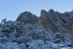
![]() by CC1 » Fri 24 Mar, 2017 2:14 pm
by CC1 » Fri 24 Mar, 2017 2:14 pm
I intended to reach the summit recently from Meander side and got as far as the woodlands above the forest floor and stream and where it opened up to a rocky and shrubby plain. There was no visable track or markers from here to get to the two obvious peaks can anyone help? Thanks
- CC1
- Nothofagus cunninghamii

- Posts: 2
- Joined: Fri 24 Mar, 2017 2:09 pm
- Region: Tasmania
Re: Mother Cummings Peak
![]() by CasualNerd » Sat 25 Mar, 2017 8:35 am
by CasualNerd » Sat 25 Mar, 2017 8:35 am
From memory it wasn't a difficult hike navigation wise, which side of the creek did you walk up ?
Did you have a map ? GPS ?
Did you have a map ? GPS ?
-
CasualNerd - Athrotaxis cupressoides

- Posts: 488
- Joined: Wed 03 Aug, 2011 3:33 pm
- Region: Tasmania
- Gender: Male
Re: Mother Cummings Peak
![]() by CC1 » Sat 25 Mar, 2017 1:02 pm
by CC1 » Sat 25 Mar, 2017 1:02 pm
I dont have a map or gps..walked up the northern side of the creek
- CC1
- Nothofagus cunninghamii
- Posts: 2
- Joined: Fri 24 Mar, 2017 2:09 pm
- Region: Tasmania
Re: Mother Cummings Peak
![]() by Thomas » Tue 11 Apr, 2017 10:45 am
by Thomas » Tue 11 Apr, 2017 10:45 am
Hi CC1,
Did you go in via the Scotts Road access..???
Rgds,
T.
Did you go in via the Scotts Road access..???
Rgds,
T.
-

Thomas - Athrotaxis cupressoides
- Posts: 130
- Joined: Wed 14 Jul, 2010 8:41 am
- Region: Tasmania
- Gender: Male
Re: Mother Cummings Peak
![]() by Rick » Tue 11 Apr, 2017 3:44 pm
by Rick » Tue 11 Apr, 2017 3:44 pm
I summitted it on Friday just gone from Smoko Rd and had no real problem following the track up. Once you start the serious ascent the track gets steep and heads NE. I noticed a lack of tape (there was a couple) but was able to find cairns and the track was reasonably obvious. There was also water running down the track which helped find the way. After what seems forever (for me anyway) you start to reach large boulders which have a few cairns to lead you to the top. Now I can't emphasise enough the importance of knowing where you need to be to make the descent.
I headed South to reach the summit, had lunch and started my return.
The problem I had was not knowing exactly where I came up. There are also a few cairns in different places which lead to nowhere. I started going down in a couple of places only to find they led to dead ends. High scrub, large rocks, no tracks!
It turns out I was around 50-60 metres off where I should have been. Once you find the right spot it is just a matter of retracing your steps back to the car.
It's a hard walk and can be a bit dodgy in places so please carry an epirb or plb, a gps, a map and a mobile phone (I had coverage). Also, if we get more rain the creek crossing could be dangerous.
It's a great walk but I would like to see it marked better on the ascent/descent and some of the false cairns on top removed.
-
Rick - Atherosperma moschatum

- Posts: 99
- Joined: Fri 09 Jan, 2009 1:55 pm
- Region: Tasmania
Re: Mother Cummings Peak
![]() by north-north-west » Tue 11 Apr, 2017 4:09 pm
by north-north-west » Tue 11 Apr, 2017 4:09 pm
The so called false cairns on top are for alternative routes. There's a pad off the northern end of the southern plateau that leads down to saddle between the two peaks - easy access from there to the Valley. Also a very old track that may or may not still exist, that climbed up the other side of the plateau. Plus routes around the top of the cliff edges.
"Mit der Dummheit kämpfen Götter selbst vergebens."
-

north-north-west - Lagarostrobos franklinii

- Posts: 15493
- Joined: Thu 14 May, 2009 7:36 pm
- Location: The Asylum
- ASSOCIATED ORGANISATIONS: Social Misfits Anonymous
- Region: Tasmania
Re: Mother Cummings Peak
![]() by Rick » Tue 11 Apr, 2017 4:26 pm
by Rick » Tue 11 Apr, 2017 4:26 pm
The couple I followed went no-where. Maybe grown over since they were put there.
-
Rick - Atherosperma moschatum
- Posts: 99
- Joined: Fri 09 Jan, 2009 1:55 pm
- Region: Tasmania
7 posts
• Page 1 of 1
Who is online
Users browsing this forum: No registered users and 48 guests