Daintreeboy's question on declination brought another question to my mind.
Ive always wondered what the difference between a true bearing and grid bearing is?
and does the difference vary between locations and map projections?
Ive done a bit of searching but cant find an answer that doesnt involve math. Which is not my strong point.
Is there a simple mans explanation?
Difference between a true bearing & a grid bearing?
Forum rules
TIP: The online Bushwalk Inventory System can help bushwalkers with a variety of bushwalk planning tasks, including: Manage which items they take bushwalking so that they do not forget anything they might need, plan meals for their walks, and automatically compile food/fuel shopping lists (lists of consumables) required to make and cook the meals for each walk. It is particularly useful for planning for groups who share food or other items, but is also useful for individual walkers.
TIP: The online Bushwalk Inventory System can help bushwalkers with a variety of bushwalk planning tasks, including: Manage which items they take bushwalking so that they do not forget anything they might need, plan meals for their walks, and automatically compile food/fuel shopping lists (lists of consumables) required to make and cook the meals for each walk. It is particularly useful for planning for groups who share food or other items, but is also useful for individual walkers.
25 posts
• Page 1 of 1
Difference between a true bearing & a grid bearing?
![]() by wildwanderer » Tue 25 Jun, 2019 7:31 pm
by wildwanderer » Tue 25 Jun, 2019 7:31 pm
-

wildwanderer - Athrotaxis selaginoides

- Posts: 1637
- Joined: Tue 02 May, 2017 8:42 am
- Location: Out of lockdown \o/
- Region: New South Wales
- Gender: Male
Re: Difference between a true bearing & a grid bearing?
![]() by Gadgetgeek » Tue 25 Jun, 2019 7:47 pm
by Gadgetgeek » Tue 25 Jun, 2019 7:47 pm
Yes, grid only relates to that map, so it doesn't really have to have a relation to reality if the surveyor doesn't want it to. It also can matter a lot on the scale, I've seen more large maps that have the grid, true and mag north as separate things, depending on how they needed to mash the projection into the frame. As to if there is a standard that is usual for the difference between, I don't know that there is one. Hopefully someone smarter than me knows more.
- Gadgetgeek
- Athrotaxis selaginoides
- Posts: 1209
- Joined: Sun 23 Sep, 2012 4:10 pm
- Region: Queensland
- Gender: Male
Re: Difference between a true bearing & a grid bearing?
![]() by wildwanderer » Tue 25 Jun, 2019 8:07 pm
by wildwanderer » Tue 25 Jun, 2019 8:07 pm
Gadgetgeek wrote:Yes, grid only relates to that map, so it doesn't really have to have a relation to reality if the surveyor doesn't want it to. It also can matter a lot on the scale, I've seen more large maps that have the grid, true and mag north as separate things, depending on how they needed to mash the projection into the frame. As to if there is a standard that is usual for the difference between, I don't know that there is one. Hopefully someone smarter than me knows more.
Lets base it on maps featuring the WGS84 (or for Australa GDA94) and UTM grids to make any explanation possibly a bit easier
-
wildwanderer - Athrotaxis selaginoides
- Posts: 1637
- Joined: Tue 02 May, 2017 8:42 am
- Location: Out of lockdown \o/
- Region: New South Wales
- Gender: Male
Re: Difference between a true bearing & a grid bearing?
![]() by andrewp » Tue 25 Jun, 2019 8:33 pm
by andrewp » Tue 25 Jun, 2019 8:33 pm
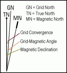
The difference between true north and grid north is the result of projecting a sphere onto a 2D surface and is known as 'grid convergence' (GC).
In UTM the world is broken into zones. NSW lies in zones 54, 55 and 56. At the centre of the zone the GC is 0. As you move to the west of the zone the GC increases, and as you move to the east it decreases i.e. becomes negative. As you move further away from the equator the variance between the edges of the zone increases. At the latitude of southern Australia it varies roughly between +2 and -2 degrees.
Topographical maps will have something like this:
In this example the Grid Mag Angle is calculated as Declination - Grid Convergence. The Grid Mag Angle is what you need to subtract (at least in eastern Australia) from the map bearing to use to navigate on the ground.
This Youtube video may help you understand. https://youtu.be/6nQffr-UIkM
- utm-grid-zone.png (98.85 KiB) Viewed 21852 times
In UTM the world is broken into zones. NSW lies in zones 54, 55 and 56. At the centre of the zone the GC is 0. As you move to the west of the zone the GC increases, and as you move to the east it decreases i.e. becomes negative. As you move further away from the equator the variance between the edges of the zone increases. At the latitude of southern Australia it varies roughly between +2 and -2 degrees.
Topographical maps will have something like this:
- Selection_001.jpg (12.49 KiB) Viewed 21852 times
In this example the Grid Mag Angle is calculated as Declination - Grid Convergence. The Grid Mag Angle is what you need to subtract (at least in eastern Australia) from the map bearing to use to navigate on the ground.
This Youtube video may help you understand. https://youtu.be/6nQffr-UIkM
-

andrewp - Athrotaxis cupressoides

- Posts: 310
- Joined: Mon 29 Aug, 2011 10:34 am
- Region: Victoria
- Gender: Male
Re: Difference between a true bearing & a grid bearing?
![]() by slparker » Tue 25 Jun, 2019 8:39 pm
by slparker » Tue 25 Jun, 2019 8:39 pm
The way that I understand it is that you cannot take a 'true bearing'. You can only shoot a magnetic bearing which is only useful because it bears a known relationship with grid north. The grid is an arbitrary projection on paper from the curved earth's surface.
If you tried to cover a globe with post it notes you would see that you can't accurately fit squares on a curved 3d surface and have them as contiguous 2d shapes... so we have to distort the real eart's surface slightly to fit them on our maps. This builds in inaccuracies where the eastings on the map can not point to true north.
I am not a cartographer but this is the wau that I understand it.
Addit: i suppose you could shoot a 'true north' bearing by subtracting the difference from true to magnetic north. The problem is that you couldn't navigate with it as maps only work on grid projections. If you wanted to get to the north pole by dead reckoning it would work, though.
(Edit: posted at the same time as andrewp's excellent explanation)
Last edited by slparker on Tue 25 Jun, 2019 9:41 pm, edited 1 time in total.
- slparker
- Athrotaxis selaginoides
- Posts: 1407
- Joined: Fri 25 Apr, 2008 10:59 pm
Re: Difference between a true bearing & a grid bearing?
![]() by wildwanderer » Tue 25 Jun, 2019 9:01 pm
by wildwanderer » Tue 25 Jun, 2019 9:01 pm
Thanks Andrewp. Very helpful
I was just pouring over some paper nsw topos and saw the grid convergence diagram. Something that is unhelpfully missing in the Geopdfs many us now commonly use (looking at you NSW Spatial services.. )
Now I understand why Sydney has a magnetic declination of +12.60
When you include the grid variance it makes sense. 10.7 is the difference between magnetic north and grid north as stated in 2017 nsw geopdf topos for the Sydney region.
then another 1.5-2 difference from grid north to true north. All up aprox 12
Though one thing i dont understand... (and my lack of basic math is showing here)
Why do we add when going from magnetic to grid? looking at the grid convergence diagram shouldnt we be subtracting? (obviously I know we add (in the east at least) but it seems counter intuitive looking at the diagram)
Last edited by wildwanderer on Tue 25 Jun, 2019 10:30 pm, edited 1 time in total.
-
wildwanderer - Athrotaxis selaginoides
- Posts: 1637
- Joined: Tue 02 May, 2017 8:42 am
- Location: Out of lockdown \o/
- Region: New South Wales
- Gender: Male
Re: Difference between a true bearing & a grid bearing?
![]() by slparker » Tue 25 Jun, 2019 10:29 pm
by slparker » Tue 25 Jun, 2019 10:29 pm
Imagine that you are walking on a 0 degrees (mag north) magnetic bearing and also walking on a football field sized map. The map is orientated to grid north. For your magnetic bearing to match the bearing of o degrees on the map, the map would have to be rotated clockwise, adding 13 degrees (rotating clockwise on a compass is addition): converting a bearing from magnetic to grid irequires ddition.it is easiest to think that you are bring over the other bearing system to match the one you have plotted.
Conversely, for grid to magnetic you plot the grid bearing and match the mag bearing by 'moving' that bearing towards the grid bearing until it matches, therefore subtracting the angle.
Conversely, for grid to magnetic you plot the grid bearing and match the mag bearing by 'moving' that bearing towards the grid bearing until it matches, therefore subtracting the angle.
- slparker
- Athrotaxis selaginoides
- Posts: 1407
- Joined: Fri 25 Apr, 2008 10:59 pm
Re: Difference between a true bearing & a grid bearing?
![]() by wildwanderer » Tue 25 Jun, 2019 10:47 pm
by wildwanderer » Tue 25 Jun, 2019 10:47 pm
slparker wrote:Imagine that you are walking on a 0 degrees (mag north) magnetic bearing and also walking on a football field sized map. The map is orientated to grid north. For your magnetic bearing to match the bearing of o degrees on the map, the map would have to be rotated clockwise, adding 13 degrees (rotating clockwise on a compass is addition): converting a bearing from magnetic to grid irequires ddition.it is easiest to think that you are bring over the other bearing system to match the one you have plotted.
Conversely, for grid to magnetic you plot the grid bearing and match the mag bearing by 'moving' that bearing towards the grid bearing until it matches, therefore subtracting the angle.
Thanks slparker. Perfect explanation. When you mentioned rotating the map to match the magnetic bearing it feel into place with a giant clang
-
wildwanderer - Athrotaxis selaginoides
- Posts: 1637
- Joined: Tue 02 May, 2017 8:42 am
- Location: Out of lockdown \o/
- Region: New South Wales
- Gender: Male
Re: Difference between a true bearing & a grid bearing?
![]() by Rileyr » Wed 26 Jun, 2019 2:45 am
by Rileyr » Wed 26 Jun, 2019 2:45 am
I think you mean grid north (map north) vs magnetic north (compass north). Or grid / mag for short.
My understanding is that Magnetic (compass) north moves slowly every year. Therefore, when the map or the grid is made it's made to the magnetic north of that year (i am presuming)
When magnetic north moves away from grid north (the map north) its called magnetic variation. Meaning there is a difference between grid and magnetic north (map and compass north)
Some maps (not many civilian maps that i have seen) give you the magnetic variation for certain years. Eg: 2005-2010 variation of 2 deg. 2010-2015 3 deg. Etc
When plotting on your map you are plotting grid bearing. You need to SUBTRACT that 2 or 3 degrees (the magnetic variation) to then shoot your mag bearing (compass bearing) in order to be accurate with your nav.
When shooting a compass bearing (mag) and then trying to plot that on a map (grid) you need to ADD the magnetic variation instead of subtract as above.
grid to mag subtract
Mag to grid add
Ps: I have never used degrees for navigation and dont even know if the mag variation is often done with degrees as they arent a very accurate nav measurement, but this is the basic practical method behind magnetic variation.
- Rileyr
- Athrotaxis cupressoides
- Posts: 148
- Joined: Mon 23 Oct, 2017 5:40 pm
- Region: Victoria
- Gender: Male
Re: Difference between a true bearing & a grid bearing?
![]() by slparker » Wed 26 Jun, 2019 8:32 am
by slparker » Wed 26 Jun, 2019 8:32 am
@Rileyr
If you are talking about Mils* vs degrees: to be scientific about it, the use of Mils in foot navigation is not more accurate; but Mils are more precise. Mils are used by the military for precision in artillery fire but for navigation on foot it make no practical difference if you are using a compass delineated in degrees or mils.
The reason for this is because of the fundamental error involved when shooting a bearing by sight and then walking on a bearing, or series of bounds reckoned within that bearing. Irrespective of the precision of your system you will usually, and predictably, be out by a couple of degrees (or 35 Mils) due to error. This is why we build in strategies in navigation to 'catch' this error (such as aiming off).
From (1994) memory, artillery fire is plotted on a map using mils and then that information is used to traverse the gun barrel via a sighting mechanism on the gun - no direct observation is taken with the compass except in rough reckoning to orient the gun. The dial sights on the gun are both precise and accurate. I suppose that it is all done by GPS and electronic compass these days. (for anyone interested in this, in their calculations they also have to have to account for the rotation of the earth whilst the artillery round is in the air)
*For the rest of the audience Mils is a system used by the army for plotting artillery fire (probably mortars and indirect small arms fire as well, I suppose) due to its precision. It is the familiar 360 degree circle divided into 6400 "Mils"
- slparker
- Athrotaxis selaginoides
- Posts: 1407
- Joined: Fri 25 Apr, 2008 10:59 pm
Re: Difference between a true bearing & a grid bearing?
![]() by wildwanderer » Wed 26 Jun, 2019 9:19 am
by wildwanderer » Wed 26 Jun, 2019 9:19 am
I wanted to clarify one more thing. 
to find the grid - magnetic angle.
For bearing 90 degrees. Location East of the angonic line.
If my magnetic declination is 12 East.(canberra)
and my grid convergence is -1.5 (im assuming its negative? because True north is west of grid north, in canberra)
shown in this diagram
Then its
bearing 90 +12 -1.5 = 100.5 degrees.
so grid magnetic angle is +10.5. Which is the postiive offset we calculate when going from a magnetic to grid bearing.
However what has confused me is scrolling down to example two on this gov webpage.
http://www.ga.gov.au/oracle/geomag/agrfform.jsp
in example two. to convert from Magnetic to Grid for Canberra.
Why are they adding the magnetic delcination and the grid convergence together? Shouldnt it be adding the declination and subtracting the convergence?
Or are they just giving the convergence a postive number to make the example easier?
sorry not sure why the 2nd pic is blurry. you can see it sharp on the webpage. http://www.ga.gov.au/oracle/geomag/agrfform.jsp
to find the grid - magnetic angle.
For bearing 90 degrees. Location East of the angonic line.
If my magnetic declination is 12 East.(canberra)
and my grid convergence is -1.5 (im assuming its negative? because True north is west of grid north, in canberra)
shown in this diagram
Then its
bearing 90 +12 -1.5 = 100.5 degrees.
so grid magnetic angle is +10.5. Which is the postiive offset we calculate when going from a magnetic to grid bearing.
However what has confused me is scrolling down to example two on this gov webpage.
http://www.ga.gov.au/oracle/geomag/agrfform.jsp
in example two. to convert from Magnetic to Grid for Canberra.
Why are they adding the magnetic delcination and the grid convergence together? Shouldnt it be adding the declination and subtracting the convergence?
Or are they just giving the convergence a postive number to make the example easier?
- 1.png (17.51 KiB) Viewed 21736 times
sorry not sure why the 2nd pic is blurry. you can see it sharp on the webpage. http://www.ga.gov.au/oracle/geomag/agrfform.jsp
-
wildwanderer - Athrotaxis selaginoides
- Posts: 1637
- Joined: Tue 02 May, 2017 8:42 am
- Location: Out of lockdown \o/
- Region: New South Wales
- Gender: Male
Re: Difference between a true bearing & a grid bearing?
![]() by slparker » Wed 26 Jun, 2019 10:08 am
by slparker » Wed 26 Jun, 2019 10:08 am
Hi WW,
I have never considered the convergence when I make the calculation.
I always thought that the convergence is an inaccuracy because the map is distorted from a 3d curved surface to a 2d sheet - that is the convergence is already contained within, and a property of, the map itself.
So when you convert grid to magnetic this convergence is contained within the G-M calculation - no need for an extra calc. This should work because you are navigating to the map (and ultimately to the map's relationship wiht the earth's surface), not to true north.
I am happy to be corrected here but this is the first that I have heard of an extra convergence calculation I am unsure why it is necessary.
Edit: there will be some inaccuracy, I suppose, given the difference between the map itself and the earth's surface but for the distances and speeds related to navigating by walking... i don't know if it makes much difference. I was trained in map reading and nav in the army and, IIRC we just used grid to magnetic and mag to grid and ignored the difference between the map and the earth's surface. It probably means that you are out by a few metres but this inaccuracy is subsumed by the errors of measurement when navigating.
- slparker
- Athrotaxis selaginoides
- Posts: 1407
- Joined: Fri 25 Apr, 2008 10:59 pm
Re: Difference between a true bearing & a grid bearing?
![]() by wildwanderer » Wed 26 Jun, 2019 10:38 am
by wildwanderer » Wed 26 Jun, 2019 10:38 am
thats correct but you still need to know the grid-mag angle. (angle between magnetic and grid north) Its this that we add or subtract when converting between Grid and Mag bearings.
If we just use the magnetic declanation to convert then its going to be out 1-2 degrees everytime. As declanation is calculating the angle between magnetic north and true north. Not that major in day to day nav but my question was more theorectical and wanting to understand the mechanics behind it.
I just dont get why Geo Science Australia has added a postive grid convergence to the postive declination to calcuate Magnetic to Grid bearing. Unless im missing something or they have deliberately made canberra grid convergence +1.5 instead of -1.5 to aid their example.
-
wildwanderer - Athrotaxis selaginoides
- Posts: 1637
- Joined: Tue 02 May, 2017 8:42 am
- Location: Out of lockdown \o/
- Region: New South Wales
- Gender: Male
Re: Difference between a true bearing & a grid bearing?
![]() by wildwanderer » Wed 26 Jun, 2019 11:18 am
by wildwanderer » Wed 26 Jun, 2019 11:18 am
To give another example.
Sydney at Katoomba the magnetic declanation is 12.186
The grid mag angle is 10.7
However for canberra the magnetic declanation is 12.291
but the grid mag angle is 13.6.
Unless the grid varience is changed substantially between the two locations I dont understand why such a large difference in grid mag angle.. as teh magnetic declanation is almost the the same.
-
wildwanderer - Athrotaxis selaginoides
- Posts: 1637
- Joined: Tue 02 May, 2017 8:42 am
- Location: Out of lockdown \o/
- Region: New South Wales
- Gender: Male
Re: Difference between a true bearing & a grid bearing?
![]() by slparker » Wed 26 Jun, 2019 11:38 am
by slparker » Wed 26 Jun, 2019 11:38 am
I think this is correct:
If you use the mag declination (true north-mag angle) to add or subtract you will be correct to the earth's surface when you do the nav but you will be incorrect to the map.
if you use the grid - mag angle to make your calculation you will be correct to the map when you make your calculation but not to the earth's surface.
- slparker
- Athrotaxis selaginoides
- Posts: 1407
- Joined: Fri 25 Apr, 2008 10:59 pm
Re: Difference between a true bearing & a grid bearing?
![]() by andrewp » Wed 26 Jun, 2019 12:34 pm
by andrewp » Wed 26 Jun, 2019 12:34 pm
wildwanderer wrote:Unless the grid variance is changed substantially between the two locations I don't understand why such a large difference in grid mag angle.. as the magnetic declination is almost the the same.
The reason is that Canberra is at the eastern side of zone 55 and Katoomba is at the western side of zone 56. Marulan (east of Goulburn) is roughly on the boundary of zones 55 and 56.
Grid convergence for Canberra is +1.23 and Katoomba is -1.48.
When taking a bearing from a map to navigate on the ground the number you subtract (or add, depending where you are) is the grid magnetic angle. If you ignore the grid convergence you will up to ~1.8 out (in SE Australia).
Here is an online grid mag angle calculator I wrote:
https://www.baysidebush.org.au/trip-program/gridmagangle
-
andrewp - Athrotaxis cupressoides
- Posts: 310
- Joined: Mon 29 Aug, 2011 10:34 am
- Region: Victoria
- Gender: Male
Re: Difference between a true bearing & a grid bearing?
![]() by wildwanderer » Wed 26 Jun, 2019 12:44 pm
by wildwanderer » Wed 26 Jun, 2019 12:44 pm
Just to conclude this.
It does appear that the grid convergence varies by 2 degrees between Sydney and Canberra.
Canberra grid varience is +1.23
Sydney (Katoomba) grid var is -1.49
So the above aus geo website is correct.
Does it matter? Not really. though if your 2 degrees out on your bearing then it translates to 36 metres over 1km. But in practice your more likely to be out by more than a few degrees just by walking/hand movement when following a bearing.
Scenarios where you might not have the grid-magnentic angle (and need to use the magnetic declanation instead). You have a screen grab of a topo, printed it and it didnt include the grid-mag angle. Magnetic declanation is easy enough to find online. grid varience in order to correctly calculate grid magnetic angle is alot harder to track down.
i had to use this tool for the above sydney and canberra examples.
http://www.ga.gov.au/geodesy/datums/red ... to_geo.jsp
EDIT. Just saw your reply Andrew. Yep thanks it makes sense now. Glad to have it all figured out. PS thats an awesome tool you wrote. Wish I had known about that before I went searching
Thanks for your help and everyone else on this thread.
-
wildwanderer - Athrotaxis selaginoides
- Posts: 1637
- Joined: Tue 02 May, 2017 8:42 am
- Location: Out of lockdown \o/
- Region: New South Wales
- Gender: Male
Re: Difference between a true bearing & a grid bearing?
![]() by ChrisJHC » Wed 26 Jun, 2019 4:01 pm
by ChrisJHC » Wed 26 Jun, 2019 4:01 pm
slparker wrote:@Rileyr
If you are talking about Mils* vs degrees: to be scientific about it, the use of Mils in foot navigation is not more accurate; but Mils are more precise. Mils are used by the military for precision in artillery fire but for navigation on foot it make no practical difference if you are using a compass delineated in degrees or mils.
The reason for this is because of the fundamental error involved when shooting a bearing by sight and then walking on a bearing, or series of bounds reckoned within that bearing. Irrespective of the precision of your system you will usually, and predictably, be out by a couple of degrees (or 35 Mils) due to error. This is why we build in strategies in navigation to 'catch' this error (such as aiming off).
From (1994) memory, artillery fire is plotted on a map using mils and then that information is used to traverse the gun barrel via a sighting mechanism on the gun - no direct observation is taken with the compass except in rough reckoning to orient the gun. The dial sights on the gun are both precise and accurate. I suppose that it is all done by GPS and electronic compass these days. (for anyone interested in this, in their calculations they also have to have to account for the rotation of the earth whilst the artillery round is in the air)
*For the rest of the audience Mils is a system used by the army for plotting artillery fire (probably mortars and indirect small arms fire as well, I suppose) due to its precision. It is the familiar 360 degree circle divided into 6400 "Mils"
And for the maths geeks out there, 6400 mils is approximately (2 x pi x 1000) which feeds nicely into the calculation for the length of an arc of a circle (in radians not degrees). For the maths pedants, 2 x pi x 1000 = 6283, but it's much easier for an infantryman under fire to work out fractions of 6400 than 6283!
This means that 1 mil = 1 metre laterally at 1000 metres distance and you can fairly easily work out multiple thereof.
- ChrisJHC
- Phyllocladus aspleniifolius

- Posts: 807
- Joined: Sat 25 Feb, 2017 8:22 pm
- Region: Victoria
- Gender: Male
Re: Difference between a true bearing & a grid bearing?
![]() by slparker » Wed 26 Jun, 2019 6:05 pm
by slparker » Wed 26 Jun, 2019 6:05 pm
Thanks Chris,
learnt today, when checking my facts, that Mils stands for 'miliradians' of which there are 6283... rounded up to 6400.
That sort of closes the circle on this discussion. (groan)
learnt today, when checking my facts, that Mils stands for 'miliradians' of which there are 6283... rounded up to 6400.
That sort of closes the circle on this discussion. (groan)
- slparker
- Athrotaxis selaginoides
- Posts: 1407
- Joined: Fri 25 Apr, 2008 10:59 pm
Re: Difference between a true bearing & a grid bearing?
![]() by Walk_fat boy_walk » Wed 26 Jun, 2019 9:46 pm
by Walk_fat boy_walk » Wed 26 Jun, 2019 9:46 pm
Find the magnetic variation for your locale on the topo map. Then add or subtract it to your bearing / angle depending on whether converting a bearing to map angle or vice versa... The military (used to?) teach (pretty *&%$#!) pnemonics: "grandma sucks" = grid - to - magnetic - subtract (as in subtract the local variation) , and "my great aunt" (I think??) = magnetic - to - grid - add. And yes you might have to to convert mils to degrees as per previous post. (And yes also as per previous post mils are more precise but not necessarily more accurate than degrees).
Meh just use a gps (flame suit on).
Sent from my F8131 using Tapatalk
Meh just use a gps (flame suit on).
Sent from my F8131 using Tapatalk
- Walk_fat boy_walk
- Lagarostrobos franklinii

- Posts: 2354
- Joined: Sat 21 Nov, 2009 6:59 am
- Gender: Male
Re: Difference between a true bearing & a grid bearing?
![]() by Rileyr » Wed 26 Jun, 2019 10:05 pm
by Rileyr » Wed 26 Jun, 2019 10:05 pm
@ slparker
I would argue that mils allow for more accurate nav over degrees because they are 17x more accurate. A bit like measuring in cm instead of mm

Edit:
I haven't, to date, done a mag variation conversion while hiking for fun. I dont even think I will take a full sized compass on the Bibbulmun in a couple of months.
Its good to know but not as good as knowing how to do a resection (finding where you are when lost). Or just simply carry a gps haha
I would argue that mils allow for more accurate nav over degrees because they are 17x more accurate. A bit like measuring in cm instead of mm
Edit:
I haven't, to date, done a mag variation conversion while hiking for fun. I dont even think I will take a full sized compass on the Bibbulmun in a couple of months.
Its good to know but not as good as knowing how to do a resection (finding where you are when lost). Or just simply carry a gps haha
- Rileyr
- Athrotaxis cupressoides
- Posts: 148
- Joined: Mon 23 Oct, 2017 5:40 pm
- Region: Victoria
- Gender: Male
Re: Difference between a true bearing & a grid bearing?
![]() by Walk_fat boy_walk » Thu 27 Jun, 2019 10:03 am
by Walk_fat boy_walk » Thu 27 Jun, 2019 10:03 am
Rileyr wrote:@ slparker
I would argue that mils allow for more accurate nav over degrees because they are 17x more accurate. A bit like measuring in cm instead of mm
Edit:
I haven't, to date, done a mag variation conversion while hiking for fun. I dont even think I will take a full sized compass on the Bibbulmun in a couple of months.
Its good to know but not as good as knowing how to do a resection (finding where you are when lost). Or just simply carry a gps haha
More granularity doesn't mean more accuracy (and degrees can by subdivided to n decimal places as well). Precision and accuracy aren't the same thing.
Also when doing a resection in theory you should still to the conversion... yes the triangulation largely cancels out the offset but not entirely (only would if the Earth was actually flat).
- Walk_fat boy_walk
- Lagarostrobos franklinii
- Posts: 2354
- Joined: Sat 21 Nov, 2009 6:59 am
- Gender: Male
Re: Difference between a true bearing & a grid bearing?
![]() by Warin » Thu 27 Jun, 2019 12:15 pm
by Warin » Thu 27 Jun, 2019 12:15 pm
Walk_fat boy_walk wrote: Precision and accuracy aren't the same thing.
True. But in measurement jargon:
Resolution : the smallest thing that you can see
Precision: how close are repeated measurements of the same thing
Accuracy: compliance with the truth
Good accuracy requires good precision and good resolution. There can be great resolution and great precision with poor accuracy.
-

Warin - Athrotaxis selaginoides
- Posts: 1467
- Joined: Sat 11 Nov, 2017 8:02 am
- Region: New South Wales
Re: Difference between a true bearing & a grid bearing?
![]() by Walk_fat boy_walk » Thu 27 Jun, 2019 2:55 pm
by Walk_fat boy_walk » Thu 27 Jun, 2019 2:55 pm
Warin wrote:Accuracy: compliance with the truth
Good accuracy requires good precision and good resolution.
There can be great resolution and great precision with poor accuracy.
The first and last points are correct. The middle one is questionable - determining/ascertaining good accuracy requires good precision and resolution... but accuracy itself is independent and more relevant to the quality (or calibration) of instruments (ie. compliance with a 'truth' as you say, which in a practical setting is generally compliance with some known standard or value).
- Walk_fat boy_walk
- Lagarostrobos franklinii
- Posts: 2354
- Joined: Sat 21 Nov, 2009 6:59 am
- Gender: Male
Re: Difference between a true bearing & a grid bearing?
![]() by Rileyr » Thu 27 Jun, 2019 3:33 pm
by Rileyr » Thu 27 Jun, 2019 3:33 pm
Wow this is technical
Sent from my SM-G950F using Tapatalk
Sent from my SM-G950F using Tapatalk
- Rileyr
- Athrotaxis cupressoides
- Posts: 148
- Joined: Mon 23 Oct, 2017 5:40 pm
- Region: Victoria
- Gender: Male
25 posts
• Page 1 of 1
Who is online
Users browsing this forum: No registered users and 55 guests