I know this is a bit off topic, but talking of access to Pelion, didn't there used to be a track from somewhere near the Arm R track to the old mines near Old Pelion. Wolfram mines? Where did this track start from?
(Admin Edit: This topic has been split if from HERE
Derelict Mines
Forum rules
Tasmania specific bushwalking discussion. Please avoid publishing details of access to sensitive areas with no tracks.
Tasmania specific bushwalking discussion. Please avoid publishing details of access to sensitive areas with no tracks.
45 posts
• Page 1 of 2 • 1, 2
Derelict Mines
![]() by Jean @ Arm R » Wed 09 Apr, 2008 12:12 am
by Jean @ Arm R » Wed 09 Apr, 2008 12:12 am
-

Jean @ Arm R - Nothofagus cunninghamii

- Posts: 6
- Joined: Mon 18 Feb, 2008 4:37 pm
- Location: Hobart
- Region: Tasmania
Re: New Pelion Hut via Walls?
![]() by Son of a Beach » Wed 09 Apr, 2008 7:49 am
by Son of a Beach » Wed 09 Apr, 2008 7:49 am
Jean @ Arm R wrote:I know this is a bit off topic, but talking of access to Pelion, didn't there used to be a track from somewhere near the Arm R track to the old mines near Old Pelion. Wolfram mines? Where did this track start from?
This is a track I've never done, but I believe it used to be the quickest way in, IF you had a 4WD AND the road was passable. From what I understand now, the road is no longer passable by any vehicles (although I'm only going on what I've heard from others). The road would be a very long walk, when added to the actual walking track.
The road is "Patons Road" and it gets as far as the old Wolfram Mines where the "Fourth Valley Track" starts. From a quick check of the map, it looks like Patons Road starts near the Lemonthyme Power Station.
I think somebody recently posted here that the bridge near the end of the track (near Old Pelion Hut) has been
Somebody who's actually done this track may be able to provide something more accurate than my ramblings based on heresay.
- Son of a Beach
- Lagarostrobos franklinii

- Posts: 6930
- Joined: Thu 01 Mar, 2007 7:55 am
- ASSOCIATED ORGANISATIONS: Bit Map (NIXANZ)
- Region: Tasmania
- Gender: Male
Re: New Pelion Hut via Walls?
![]() by norts » Wed 09 Apr, 2008 8:07 am
by norts » Wed 09 Apr, 2008 8:07 am
Last time I was at Old Pelion, Jan 07, the bridge was still there but it had a sign, that said it was closed. I have also spoken to a couple of track rangers and they said that the track (not the road)was over grown and alot of trees over it.
This could be the usual Parks story, close the track and then we do not have to maintain it.
Roger
This could be the usual Parks story, close the track and then we do not have to maintain it.
Roger
-
norts - Lagarostrobos franklinii
- Posts: 2008
- Joined: Wed 01 Aug, 2007 10:45 am
- Location: Germantown Tas.
- Region: Tasmania
Re: New Pelion Hut via Walls?
![]() by corvus » Wed 09 Apr, 2008 6:05 pm
by corvus » Wed 09 Apr, 2008 6:05 pm
The Last time I went up this track there were several large trees across it and a major washout which precludes vehicle access and the walk up Paton's road 25km to the Mine would be boring and require an overnight stay at the start of the track which is very steep.I believe that this is one track we can forget about now , the bridge at Old Pelion was condemned last time I was there in Jan this year and I wont be surprised if it is removed.
collige virgo rosas
-

corvus - Vercundus gearus-freakius

- Posts: 5488
- Joined: Mon 23 Apr, 2007 7:24 pm
- Location: Devonport
- Region: Tasmania
- Gender: Male
Re: New Pelion Hut via Walls?
![]() by Joe » Wed 09 Apr, 2008 9:27 pm
by Joe » Wed 09 Apr, 2008 9:27 pm
You can access the mine from the south though can you? Its something that has interested me before...I love poking around old mining sites. The blue tier is spectacular for that.
-

Joe - in vino veritas
- Posts: 669
- Joined: Mon 26 Mar, 2007 10:35 pm
- Location: Devonport Tas
- ASSOCIATED ORGANISATIONS: Stoney Creek Outdoor Equipment.
- Region: Tasmania
Re: New Pelion Hut via Walls?
![]() by corvus » Wed 09 Apr, 2008 10:02 pm
by corvus » Wed 09 Apr, 2008 10:02 pm
TWF the Woolfram Mine is accessible from both ends but not really worth the effort of a hard long walk,just an Adit and last time I was there old huts?? if you want to check out a really cool mine site the Devonport Gold Mine (it may be Devon) at Black Bluff is the go, can be done as a long Day walk, better overnighter tho .
Great photo ops with machinery still in situ and triffik views from BB to Cradle and if it hasn't been totally wrecked since my last visit there is a mine workers hut there.
Great photo ops with machinery still in situ and triffik views from BB to Cradle and if it hasn't been totally wrecked since my last visit there is a mine workers hut there.
collige virgo rosas
-
corvus - Vercundus gearus-freakius
- Posts: 5488
- Joined: Mon 23 Apr, 2007 7:24 pm
- Location: Devonport
- Region: Tasmania
- Gender: Male
Re: New Pelion Hut via Walls?
![]() by Joe » Thu 10 Apr, 2008 7:40 am
by Joe » Thu 10 Apr, 2008 7:40 am
corvus wrote:TWF the Woolfram Mine is accessible from both ends but not really worth the effort of a hard long walk,just an Adit and last time I was there old huts?? if you want to check out a really cool mine site the Devonport Gold Mine (it may be Devon) at Black Bluff is the go, can be done as a long Day walk, better overnighter tho .
Great photo ops with machinery still in situ and triffik views from BB to Cradle and if it hasn't been totally wrecked since my last visit there is a mine workers hut there.
Anyone able to provide more detailed notes on finding this one? Might need a new thread I guess...I think I might have just found my next overnight walk
-
Joe - in vino veritas
- Posts: 669
- Joined: Mon 26 Mar, 2007 10:35 pm
- Location: Devonport Tas
- ASSOCIATED ORGANISATIONS: Stoney Creek Outdoor Equipment.
- Region: Tasmania
Re: New Pelion Hut via Walls?
![]() by corvus » Thu 10 Apr, 2008 5:58 pm
by corvus » Thu 10 Apr, 2008 5:58 pm
TWF if you are into mine sites Nic Haygarths On the Road to Cradle is a good little book about them ,
I will scan the info on the DPA(Devonport Prospecting Association) mine on Black Bluff and send it to you on Friday ,he sets out how to find it however I think his timing is a bit light on but I did have about 9 scouts with me at the time so that may be clouding my memory from 17 years ago.
I would interested in doing it again so give me a shout when you intend going and we can hook up if you like.
corvus
collige virgo rosas
-
corvus - Vercundus gearus-freakius
- Posts: 5488
- Joined: Mon 23 Apr, 2007 7:24 pm
- Location: Devonport
- Region: Tasmania
- Gender: Male
Re: New Pelion Hut via Walls?
![]() by Joe » Thu 10 Apr, 2008 7:10 pm
by Joe » Thu 10 Apr, 2008 7:10 pm
I have Speculators copy of on the road to cradle beside the bed at moment. Must give that back to him...some great walks in there. The walk from Lake Gairdner is another that im keen on...might have to do a friday after work up to Gairdner camp night then early start Saturday up there sometime soon too.
-
Joe - in vino veritas
- Posts: 669
- Joined: Mon 26 Mar, 2007 10:35 pm
- Location: Devonport Tas
- ASSOCIATED ORGANISATIONS: Stoney Creek Outdoor Equipment.
- Region: Tasmania
Re: New Pelion Hut via Walls?
![]() by corvus » Thu 10 Apr, 2008 7:59 pm
by corvus » Thu 10 Apr, 2008 7:59 pm
Done that one also b4 the book was written and if I remember there is another point of interest after the Bismouth Mine and there an another Gold Mine in the area.
We did this as a day walk camping at Lake Gairdener overnight but with a really early start could be done as a day walk,
This area can also get you to the DPM mine but have only 4wd it from the mine down and don't have a clue to distance walking wise ,I do remember it being an horrendous trip with lots of bodywork required on many vehicles
Looks like you wont need my email scan of the info but don't we have some great Day walks /Overnighters in our neck of the woods
collige virgo rosas
-
corvus - Vercundus gearus-freakius
- Posts: 5488
- Joined: Mon 23 Apr, 2007 7:24 pm
- Location: Devonport
- Region: Tasmania
- Gender: Male
Re: New Pelion Hut via Walls?
![]() by corvus » Thu 10 Apr, 2008 9:38 pm
by corvus » Thu 10 Apr, 2008 9:38 pm
Lake Gairdener camps sites were good last time I camped there 17years ago (SHEES I am now feeling old ) and upon reflection this walk could be done one day with a really early start (I think) but much better as as an overnighter
to explore the other things.
to explore the other things.
Last edited by corvus on Wed 16 Apr, 2008 6:15 pm, edited 1 time in total.
collige virgo rosas
-
corvus - Vercundus gearus-freakius
- Posts: 5488
- Joined: Mon 23 Apr, 2007 7:24 pm
- Location: Devonport
- Region: Tasmania
- Gender: Male
Re: Derelict Mines
![]() by Son of a Beach » Fri 11 Apr, 2008 7:40 am
by Son of a Beach » Fri 11 Apr, 2008 7:40 am
(Note that the last few posts of this topic have been split off to: So Many Walks on Our Little Island.)
- Son of a Beach
- Lagarostrobos franklinii
- Posts: 6930
- Joined: Thu 01 Mar, 2007 7:55 am
- ASSOCIATED ORGANISATIONS: Bit Map (NIXANZ)
- Region: Tasmania
- Gender: Male
Re: Derelict Mines
![]() by tasadam » Fri 11 Apr, 2008 2:44 pm
by tasadam » Fri 11 Apr, 2008 2:44 pm
We tried getting in to Old Pelion Feb 05. The old track had a solid steel gate on it which was manageable with a small 4wd. But a few km further on, there was a wash out / unstable remnants of a bridge that prevented us getting further in, and it wasn't worth proceeding so we retreated and went in via Arm River track, ended up only having time to get to Lake Ayr on first day due to that diversion.
Washout -

Getting around gate -

Washout -
Getting around gate -
-

tasadam - Magnus administratio

- Posts: 5900
- Joined: Tue 10 Apr, 2007 6:58 pm
- Location: Near Devonport, Tasmania
- ASSOCIATED ORGANISATIONS: TasmaniART, Smitten Merino, Macpac
- Region: Tasmania
- Gender: Male
Re: Derelict Mines
![]() by bluewombat » Sat 12 Apr, 2008 5:57 pm
by bluewombat » Sat 12 Apr, 2008 5:57 pm
I tried walking down the Wolfram mines track from Old Pelion about 2 years back. The first hour is quite pleasant but then you come to the part of the track that has 10 gazillion trees across it, we spent a while going over and under but after the first gazillion we got sick of it and went back up to Old Pelion. Looks like it is not easy from either end really. If you have some spare time around old Pelion I would recommend a leisurely stroll down stream until you hit a reasonably high waterfall, there are some beautiful pools and ferns along the way not to mention the old mine cutting (I think they were after copper but dont quote me) that was the reason for people going to the area originally
bw
bw
Even a long life is short
HPB
HPB
-

bluewombat - Athrotaxis cupressoides

- Posts: 367
- Joined: Sun 10 Feb, 2008 3:55 pm
- Region: Tasmania
Re: Derelict Mines
![]() by flyfisher » Sat 12 Apr, 2008 9:42 pm
by flyfisher » Sat 12 Apr, 2008 9:42 pm
About 15 years ago I drove from Lemonthyme power station to the last creek on the road where the bridge was not very safe.
This was in a Hi -Ace van and the road wasn't too bad. I am pretty sure you wouldn't get up there now, though because of nil maintainance.Does seem a pity because this area is now much harder to get to, and old mines are usually interesting to explore.
Anybody know Parks attitude or policy on access roads of this type.
Flyfisher
If you don't know what I'm talking about, then you need to drink more.
-
flyfisher - Athrotaxis selaginoides

- Posts: 1528
- Joined: Sat 14 Jul, 2007 8:39 pm
- Location: hobart
- ASSOCIATED ORGANISATIONS: landrover owners club of tasmania
- Region: Tasmania
Re: Derelict Mines
![]() by gorby » Sun 13 Apr, 2008 9:07 pm
by gorby » Sun 13 Apr, 2008 9:07 pm
the road to the wolfram mine is listed in the places to ride booklet for offroad motorcycling produced by the government.
the official status of the road is to have no maintainance on it and basically let nature reclaim it.
We usually travel it about once a year and it is becoming more and more overgrown and blocked by falling trees.
On our last trip up there on motorcycles,we found a couple of overseas hikers walking in to pelion plains.they had walked from lorinna (over 30km ) and were still a long way from the wolfram mines.It was 3pm and one was laying on the track in his sleeping bag absolutley tired out.
This route in must still be listed in some booklets.
-

gorby - Athrotaxis cupressoides
- Posts: 103
- Joined: Thu 20 Sep, 2007 9:24 am
- Location: deloraine
Re: Derelict Mines
![]() by corvus » Sun 13 Apr, 2008 9:42 pm
by corvus » Sun 13 Apr, 2008 9:42 pm
gorby you have hit the nail on the head this track is just ok for trail bikes now ,jeez I remember taking my first SWB cruiser up there in 74 just after the 44th transport coy had gone in there on an exercise and built bridges over the creeks etc,mrs corvus was not amused and got out at every sapling bridge ,got to the mine and examined the shaft from memory it was not very deep.Fast forward to 79 and the mine had been re opened then closed (they put the steel gates in ) 4wd club headed up the track which was still passable and the hut was still ok however the mine adit had a gate in it and I suspect that remains today all in all it is not a worthwhile walk in my opinion.
As per my previous post and that of others I think Parks are correct in discouraging anyone from using this track as we should ,we we have much better access from other areas especially the much improved Arm River Track which is a credit to Parks and the Track workers.
As per my previous post and that of others I think Parks are correct in discouraging anyone from using this track as we should ,we we have much better access from other areas especially the much improved Arm River Track which is a credit to Parks and the Track workers.
collige virgo rosas
-
corvus - Vercundus gearus-freakius
- Posts: 5488
- Joined: Mon 23 Apr, 2007 7:24 pm
- Location: Devonport
- Region: Tasmania
- Gender: Male
Re: Derelict Mine Walks
![]() by tastrekker » Sun 13 Apr, 2008 10:00 pm
by tastrekker » Sun 13 Apr, 2008 10:00 pm
Here's the derelict mine walks I can think of.

Devon Mine
This is the best mine site I've bushwalked to. I expect the access has changed since Nic Haygarth wrote "On the Road to Cradle." His description starts on
a 4WD track that is now a brand-new side-road labelled "Cethana" heading east from Daisy Dell. (A new logging road I suspect.) The walk is quite long (but possibly shortened due to the new road) and it descends deep into the Dove River gorge. At the end of the track is a derelict hut called the "Hotel Hilton Hell Hole" (must have been classy in its day) and a flying fox over the river to the mine on the other side (pictured below). In the main addit, there are tramway remains and a very impressive shaft head frame (pictured above). EXTREME CARE should be taken. Just before you reach the headframe, there is another water filled open shaft which is very difficult to see. We measured the main shaft to be over 30 metres deep which takes it well below river level. Given the mine's location, I expect the Dove River flows directly into the adit at times.

Pelion Wolfram Mine
My first trip to Mt Ossa started from here in 1983. This track made for a very short walk in to Pelion Plains. I can remember at least 2 gated adits in the
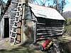
hillside. Two wheel drive access was fine as mining had only recently stopped and the road was in good condition. In 1994 I rode my pushbike in to the Wolfram Mine and the road was just passable as far as the damaged bridge just before the mine. When we arrived at the hut (below), I was surprised to find a heap of people there. Someone had broken their ankle and had been carried (shouldered) this far to wait for a Parks 4WD to pick them up. Perhaps this was one of the last vehicles to go all the way in.

In 2004, a colleague mountain biked in with a group of quad bikes. The road had deteriorated to the point where she was able to keep pace with the quad bikes as they had to spend a lot of time negotiating obstacles.
I still hope I can return to Patons Road as I would like to find the buttresses of Sloanes Bridge and perhaps find the Razorback Track up to the Commonwealth Creek Mines (see below).
Pelion Copper Mines
Located just down stream from the Old Pelion Hut. Not much to look at. I like mines with a good explorable adit and/or shafts.
DPA Mine
As mentioned above, this is over the western flank of Black Bluff. I did this by pushbike so I also can't offer much help with walking times. It's a good
one to explore as you can enter the adit for a certain way and there are remains of the tramway that was used to cart ore to the surface. I tried to follow
the road down the valley beyond the mine as the map showed it continuing through to Middlesex. However, it was completely overgrown by button grass. I was sick of carrying my bike so I returned to Smiths Plains the way I came.
Lake Will
There's evidence of surface mining on the Lake Will Track only a few metres from the Overland Track. Nothing exciting though.
Commonwealth Creek Mines
I read about these mines in another Nic Hargarth book about the history of the Mersey-Forth high country. I went dangerously close to these mines on a walk to the Hydro Hut when we visited Razorback Falls but we did not go out of our way enough to fossick. I've since heard that some equipment and water race remains can be found if you're keen enough. We were fascinated to find a large log with huge square metal pegs in it close to Lake McRae. You can read about my Hydro Hut expedition here. As the crow flies, the Hydro Hut is close to the Wolfram Mine, but 700 metres higher.
Mt Ossa
The track up to the saddle between Ossa Thetis passes by a small coal mine adit high on Ossa's NW flank. While there's not much to look at, I was fascinated that someone would be keen enough to mine way up there. I've since learned that Ewart's Track from Pelion through the Wallace and Murchison River valleys passed over this saddle so perhaps this mine dates from when this was a thoroughfare of sorts.
Dolcoath Hill Mines
This is another "On the Road to Cradle" walk from Nic Hargarth's book. This one didn't inspire me much. All the mines were alluvial sluicing so there's not
much to look at unless you are into gem stones in which case, I believe this is one of the best fossicking spots in the state. The highlight for me on this
walk was a derelict hut with a couch on the veranda facing a view to Cradle Mountain past the HV powerlines from the Pieman Scheme.
Thorsby's Tunnel
A good one to take the children to. A short walk along the track from Ferndene, this adit is long enough to make it fairly dark without the torch and
there's a gate to protect the vertical shaft at the end.
Round Mountain Mine
This was just 2 wheel drivable when I was last there about 5 years ago but some of the ruts were over 1 metre deep so this area may have now become the exclusive domain of bushwalkers or mountain bike riders. The main adit is where the main road from Staverton to Lorinna used to cross Machinery Creek before the Hydro Roads were constructed. It is a large gaping hole in the mountainside from which deep slimy water emanates which discouraged me from exploring too far beyond the entrance. Apparently my grandfather-in-law used to work at this mine.
Jane River Goldfield
Speaking of my grandfather-in-law, he is credited with cutting the original Jane River Track which now forms the first part of the Frenchmans Cap Track over the infamous 'Sodden Lodden.' The Jane River gold fields is a derelict mining area I would love to visit because of Mrs TasTrekker's family connection. However, the lack of bridge over the Franklin at the 'new' Jane River Track has discouraged me from doing so. Maybe one day! I have read about groups using 'The Jane' as access to reach Algonkian Mountain and the POWs. I would love to hear from anyone who has been there.
Devon Mine
This is the best mine site I've bushwalked to. I expect the access has changed since Nic Haygarth wrote "On the Road to Cradle." His description starts on
a 4WD track that is now a brand-new side-road labelled "Cethana" heading east from Daisy Dell. (A new logging road I suspect.) The walk is quite long (but possibly shortened due to the new road) and it descends deep into the Dove River gorge. At the end of the track is a derelict hut called the "Hotel Hilton Hell Hole" (must have been classy in its day) and a flying fox over the river to the mine on the other side (pictured below). In the main addit, there are tramway remains and a very impressive shaft head frame (pictured above). EXTREME CARE should be taken. Just before you reach the headframe, there is another water filled open shaft which is very difficult to see. We measured the main shaft to be over 30 metres deep which takes it well below river level. Given the mine's location, I expect the Dove River flows directly into the adit at times.
Pelion Wolfram Mine
My first trip to Mt Ossa started from here in 1983. This track made for a very short walk in to Pelion Plains. I can remember at least 2 gated adits in the
hillside. Two wheel drive access was fine as mining had only recently stopped and the road was in good condition. In 1994 I rode my pushbike in to the Wolfram Mine and the road was just passable as far as the damaged bridge just before the mine. When we arrived at the hut (below), I was surprised to find a heap of people there. Someone had broken their ankle and had been carried (shouldered) this far to wait for a Parks 4WD to pick them up. Perhaps this was one of the last vehicles to go all the way in.
In 2004, a colleague mountain biked in with a group of quad bikes. The road had deteriorated to the point where she was able to keep pace with the quad bikes as they had to spend a lot of time negotiating obstacles.
I still hope I can return to Patons Road as I would like to find the buttresses of Sloanes Bridge and perhaps find the Razorback Track up to the Commonwealth Creek Mines (see below).
Pelion Copper Mines
Located just down stream from the Old Pelion Hut. Not much to look at. I like mines with a good explorable adit and/or shafts.
DPA Mine
As mentioned above, this is over the western flank of Black Bluff. I did this by pushbike so I also can't offer much help with walking times. It's a good
one to explore as you can enter the adit for a certain way and there are remains of the tramway that was used to cart ore to the surface. I tried to follow
the road down the valley beyond the mine as the map showed it continuing through to Middlesex. However, it was completely overgrown by button grass. I was sick of carrying my bike so I returned to Smiths Plains the way I came.
Lake Will
There's evidence of surface mining on the Lake Will Track only a few metres from the Overland Track. Nothing exciting though.
Commonwealth Creek Mines
I read about these mines in another Nic Hargarth book about the history of the Mersey-Forth high country. I went dangerously close to these mines on a walk to the Hydro Hut when we visited Razorback Falls but we did not go out of our way enough to fossick. I've since heard that some equipment and water race remains can be found if you're keen enough. We were fascinated to find a large log with huge square metal pegs in it close to Lake McRae. You can read about my Hydro Hut expedition here. As the crow flies, the Hydro Hut is close to the Wolfram Mine, but 700 metres higher.
Mt Ossa
The track up to the saddle between Ossa Thetis passes by a small coal mine adit high on Ossa's NW flank. While there's not much to look at, I was fascinated that someone would be keen enough to mine way up there. I've since learned that Ewart's Track from Pelion through the Wallace and Murchison River valleys passed over this saddle so perhaps this mine dates from when this was a thoroughfare of sorts.
Dolcoath Hill Mines
This is another "On the Road to Cradle" walk from Nic Hargarth's book. This one didn't inspire me much. All the mines were alluvial sluicing so there's not
much to look at unless you are into gem stones in which case, I believe this is one of the best fossicking spots in the state. The highlight for me on this
walk was a derelict hut with a couch on the veranda facing a view to Cradle Mountain past the HV powerlines from the Pieman Scheme.
Thorsby's Tunnel
A good one to take the children to. A short walk along the track from Ferndene, this adit is long enough to make it fairly dark without the torch and
there's a gate to protect the vertical shaft at the end.
Round Mountain Mine
This was just 2 wheel drivable when I was last there about 5 years ago but some of the ruts were over 1 metre deep so this area may have now become the exclusive domain of bushwalkers or mountain bike riders. The main adit is where the main road from Staverton to Lorinna used to cross Machinery Creek before the Hydro Roads were constructed. It is a large gaping hole in the mountainside from which deep slimy water emanates which discouraged me from exploring too far beyond the entrance. Apparently my grandfather-in-law used to work at this mine.
Jane River Goldfield
Speaking of my grandfather-in-law, he is credited with cutting the original Jane River Track which now forms the first part of the Frenchmans Cap Track over the infamous 'Sodden Lodden.' The Jane River gold fields is a derelict mining area I would love to visit because of Mrs TasTrekker's family connection. However, the lack of bridge over the Franklin at the 'new' Jane River Track has discouraged me from doing so. Maybe one day! I have read about groups using 'The Jane' as access to reach Algonkian Mountain and the POWs. I would love to hear from anyone who has been there.
Last edited by tastrekker on Wed 16 Apr, 2008 7:07 am, edited 1 time in total.
-

tastrekker - Athrotaxis cupressoides
- Posts: 499
- Joined: Thu 20 Sep, 2007 9:04 pm
- Location: Lenah Valley
- Region: Tasmania
- Gender: Male
Re: Derelict Mines
![]() by flyfisher » Mon 14 Apr, 2008 9:35 pm
by flyfisher » Mon 14 Apr, 2008 9:35 pm
G'Day,TT Back in 1981 a friend and I went to Jane River or Warnes Lookout on a couple of motor bikes. 28 kay's took about 2 hours in 1.5 hours out.There was at that time a bridge over the Franklin River which was a bit scarey but not too bad.There was corduroy on some buttongrass plains and bridges over most sceeks.Erebus rivulet --a larger deep creek had a substantial bridge.I think at the time there may still have been a current mining lease on an area there.Short of Jane R. there was quite a large hut ,in good repair but seemed to be abandoned.There was some old machinery about and an old backhoe.
There were quite a few deep holes dug which we thought were probably to catch any water bourne gold.
I have some photos which I will post when I locate them.
Some yeays before our trip a party including Helen Gee launched lilos into Erebus Rivulet ,paddled to the Jane then down to the Franklin and Gordon .
H. Gee was one of the founders of the Wilderness Society .
F.Fisher
If you don't know what I'm talking about, then you need to drink more.
-
flyfisher - Athrotaxis selaginoides
- Posts: 1528
- Joined: Sat 14 Jul, 2007 8:39 pm
- Location: hobart
- ASSOCIATED ORGANISATIONS: landrover owners club of tasmania
- Region: Tasmania
Re: Derelict Mines
![]() by flyfisher » Mon 14 Apr, 2008 9:44 pm
by flyfisher » Mon 14 Apr, 2008 9:44 pm
Jane River was also logged for huon pine many years ago.
Some of the piners , Morrisons I think dragged a punt up the Franklin, then up the Jane ,in some parts using a block and tackle and going overland.
This punt was then left up there and supplies were taken in via the walking track.Quite a feat.
Fly Fisher
Some of the piners , Morrisons I think dragged a punt up the Franklin, then up the Jane ,in some parts using a block and tackle and going overland.
This punt was then left up there and supplies were taken in via the walking track.Quite a feat.
Fly Fisher
If you don't know what I'm talking about, then you need to drink more.
-
flyfisher - Athrotaxis selaginoides
- Posts: 1528
- Joined: Sat 14 Jul, 2007 8:39 pm
- Location: hobart
- ASSOCIATED ORGANISATIONS: landrover owners club of tasmania
- Region: Tasmania
Re: Derelict Mines
![]() by bluewombat » Tue 15 Apr, 2008 6:45 pm
by bluewombat » Tue 15 Apr, 2008 6:45 pm
Mt Ossa
The track up to the saddle between Ossa Thetis passes by a small coal mine adit high on Ossa's NW flank. While there's not much to look at, I was fascinated that someone would be keen enough to mine way up there. I've since learned that Ewart's Track from Pelion through the Wallace and Murchison River valleys passed over this saddle so perhaps this mine dates from when this was a thoroughfare of sorts.
This one is a classic I had a look at it a couple of years back on the way to Thetis, hard to believe that someone used to go up there to mine a bit of coal. One of the rangers told me that it was one man and his donkey who used regularly go up and down for a load...dont know if this is true but it is a fair slog up there from the Overland track let alone anywhere more distant (Mole Creek ??)
bw
Even a long life is short
HPB
HPB
-
bluewombat - Athrotaxis cupressoides
- Posts: 367
- Joined: Sun 10 Feb, 2008 3:55 pm
- Region: Tasmania
Re: Derelict Mines
![]() by gorby » Tue 15 Apr, 2008 11:22 pm
by gorby » Tue 15 Apr, 2008 11:22 pm
this is a pic of the washaway on the patons road route to pelion plains,it was taken a few years ago and has worsened.
This was the furtherst point that a four wheel drive car could get to.
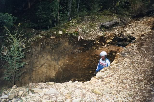
A picture in a previous post shows the washed out earth and log bridge which would probably stop most drivers now and the reason the boom gate is shut.
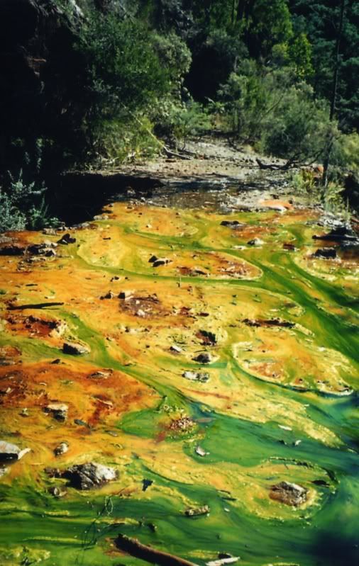
this pic is of the muck that is flowing (growing ?) out of the round hill mine adit.taken several years ago
This was the furtherst point that a four wheel drive car could get to.
A picture in a previous post shows the washed out earth and log bridge which would probably stop most drivers now and the reason the boom gate is shut.
this pic is of the muck that is flowing (growing ?) out of the round hill mine adit.taken several years ago
Last edited by gorby on Wed 16 Apr, 2008 6:34 pm, edited 2 times in total.
-
gorby - Athrotaxis cupressoides
- Posts: 103
- Joined: Thu 20 Sep, 2007 9:24 am
- Location: deloraine
Re: Derelict Mines
![]() by tastrekker » Wed 16 Apr, 2008 7:18 am
by tastrekker » Wed 16 Apr, 2008 7:18 am
I've posted some photos in my entry above.
I absolutely love Gorby's picture of the slime at Round Hill Mine. I'm not heavily into mining in wilderness areas but I must concede that environmental responsibility from mining companies has come a long way since the time this mine was abandoned.
It is interesting to note that in the additional forests protected under Tasmania's Community Forest Agreement, they are still open to mining. At least one tourist operator in the Tarkine has had to change their itinerary when a large area was cleared at the base of a mountain (Mt Bolton I think) to clear space for an exploratory drilling rig.
-
tastrekker - Athrotaxis cupressoides
- Posts: 499
- Joined: Thu 20 Sep, 2007 9:04 pm
- Location: Lenah Valley
- Region: Tasmania
- Gender: Male
Re: Derelict Mines
![]() by billyboy » Fri 10 Oct, 2008 8:38 pm
by billyboy » Fri 10 Oct, 2008 8:38 pm
A few notes regarding the track to the Devonport Prospecting Assn mine on the back of Black Bluff.
I went there last week(end of Sept 08). Access from the north is almost as described in the additions and correction notes in Nic Haygarth's On The Road To Cradle, except that you can drive a bit further than in the book.
Turn left from the Smiths Plains Road at the 'Black Bluff Track' sign, go for 1.2km (CORRECTION 1.8km) on a good gravel road then turn right onto a narrower track/road.This would probably be where 2WD vehicles would park. The track soon gets a bit rough with a couple of small creek crossings esp. after rain or snow melts. We parked our Suzuki 4WD about 1km up the track near the foot of the range just before a larger washout where a creek crosses over the track. It looks like others park here too.
Soon after starting the walk there are a couple of big bog holes and then the track goes almost in a straight line up the range, good walking on a loose steep rocky narrow and washed out track but even well equipped 4WDs would battle with poor traction and tree roots across the track. After about an hours walk (with our 9y.o) you get up onto the edge of the range and then go about another 1/2hr uphill on a more gentle incline. Then it levels out across button grass before heading south to the mine site. Due to poor weather closing in we had to turn back about 1 km from the mine. Good views north towards the coast, east to Mt Roland, south over Moina to Cradle Mt, Barn Bluff and another mountain in the Cradle region that I have not identified yet.
Most of the track is as depicted on the 1:25000 Tasmap series, 1986 edition but there are many new forestry roads in the Smiths Plains area that are not on the map. Before this visit I was last up there in 1977 as a 15y.o. scout with the 2nd Uverstone Scouts. Our leader for that trip was the late Dr John Pickford of Ulverstone who knew that area well. That day we walked to the DPA mine then back up and along the ridge to Paddy's Lake, climbed to the top of Black Bluff then walked down to Loongana via Brookes track and waded across the Leven to our pre-arranged pick up car, the bridge was not built in those days. Made a few corrections on 22-11-08. Billyboy.
Last edited by billyboy on Sat 22 Nov, 2008 8:11 pm, edited 1 time in total.
- billyboy
- Nothofagus cunninghamii
- Posts: 9
- Joined: Thu 09 Oct, 2008 5:23 pm
- Location: ex Ulverstone now Melbourne
Re: Derelict Mines
![]() by corvus » Fri 10 Oct, 2008 9:58 pm
by corvus » Fri 10 Oct, 2008 9:58 pm
Looks like the track has not changed so much since I took City of Devonport Scouts up there for an overnighter around 1993.
collige virgo rosas
-
corvus - Vercundus gearus-freakius
- Posts: 5488
- Joined: Mon 23 Apr, 2007 7:24 pm
- Location: Devonport
- Region: Tasmania
- Gender: Male
Re: Derelict Mines
![]() by Taurë-rana » Sun 12 Oct, 2008 10:08 am
by Taurë-rana » Sun 12 Oct, 2008 10:08 am
We've driven to the DPA mine a few times, but this track is not recommended unless you are experienced at 4WDriving and have a "proper" 4WD. There are a couple of spots that are very hard to get up, and many vehicles do some mostly minor damage going up or down. We have also gone right through and out over the Lee River after doing some track work, but this goes out over private property.
Patons Road was driveable to within half a km of the Wolfram Mine a couple of years ago in 4WD's over dodgy bridges. It is worth visiting if you are interested in mines.
Patons Road was driveable to within half a km of the Wolfram Mine a couple of years ago in 4WD's over dodgy bridges. It is worth visiting if you are interested in mines.
Peak bagging points: 170ish
Recent walks - Picton, Wylds Crag, Rogoona
Recent walks - Picton, Wylds Crag, Rogoona
-

Taurë-rana - Phyllocladus aspleniifolius

- Posts: 960
- Joined: Mon 14 Jan, 2008 8:28 pm
- Location: Devonport
- Region: Tasmania
Re: Derelict Mines
![]() by corvus » Sun 12 Oct, 2008 5:42 pm
by corvus » Sun 12 Oct, 2008 5:42 pm
Interesting to note that you can still "4WD " the track having done it several times in the late seventies.
collige virgo rosas
-
corvus - Vercundus gearus-freakius
- Posts: 5488
- Joined: Mon 23 Apr, 2007 7:24 pm
- Location: Devonport
- Region: Tasmania
- Gender: Male
Re: Derelict Mines
![]() by theMISSIONARY » Sun 12 Oct, 2008 7:16 pm
by theMISSIONARY » Sun 12 Oct, 2008 7:16 pm
Last time i went to the Devon mine the ruts on the down hill(south side) were Very deep 1M+ it would have been hard work on the dirt bike let alone 4x4
i have some pic's some where i will have to up load them
i have some pic's some where i will have to up load them
-

theMISSIONARY - Nothofagus gunnii

- Posts: 36
- Joined: Thu 19 Jun, 2008 9:44 pm
- Location: Deroport
- Region: Tasmania
- Gender: Male
Re: Derelict Mines
![]() by flyfisher » Sun 12 Jul, 2009 1:54 pm
by flyfisher » Sun 12 Jul, 2009 1:54 pm
There has been on the last 2 sundays a program o ABC radio (Chris Wisbys show about 10 am) on the history of the Jane river goldfield.
FF
FF
If you don't know what I'm talking about, then you need to drink more.
-
flyfisher - Athrotaxis selaginoides
- Posts: 1528
- Joined: Sat 14 Jul, 2007 8:39 pm
- Location: hobart
- ASSOCIATED ORGANISATIONS: landrover owners club of tasmania
- Region: Tasmania
Re: Derelict Mines
![]() by corvus » Sun 12 Jul, 2009 5:47 pm
by corvus » Sun 12 Jul, 2009 5:47 pm
anyone interested in old mining activity this is a good read.
http://www.mrt.tas.gov.au/mrtdoc/dominf ... 989_32.pdf
C
http://www.mrt.tas.gov.au/mrtdoc/dominf ... 989_32.pdf
C
collige virgo rosas
-
corvus - Vercundus gearus-freakius
- Posts: 5488
- Joined: Mon 23 Apr, 2007 7:24 pm
- Location: Devonport
- Region: Tasmania
- Gender: Male
45 posts
• Page 1 of 2 • 1, 2
Who is online
Users browsing this forum: No registered users and 41 guests