I didn't end up cycling down south way at all during my time off on my epic bicyclking adventure, could not be gone for more than 4 days at a time, so have done adventures in fits and spurts, all rather enjoyable though.
Looking forward to a venture on down in warmer months and also hearing how Alana84's jaunt goes.
Multiday walks in Kosciuszko NP
Forum rules
NSW & ACT specific bushwalking discussion. Please avoid publishing details of access to sensitive areas with no tracks.
NSW & ACT specific bushwalking discussion. Please avoid publishing details of access to sensitive areas with no tracks.
103 posts
• Page 4 of 4 • 1, 2, 3, 4
Re: Multiday walks in Kosciuszko NP
![]() by Ms_Mudd » Fri 25 Sep, 2020 10:21 am
by Ms_Mudd » Fri 25 Sep, 2020 10:21 am
-

Ms_Mudd - Athrotaxis selaginoides

- Posts: 1038
- Joined: Fri 23 Mar, 2018 11:26 am
- Location: Tas
- Region: Tasmania
- Gender: Female
Re: Multiday walks in Kosciuszko NP
![]() by Alana84 » Mon 28 Sep, 2020 8:01 am
by Alana84 » Mon 28 Sep, 2020 8:01 am
Ms_Mudd wrote:I didn't end up cycling down south way at all during my time off on my epic bicyclking adventure, could not be gone for more than 4 days at a time, so have done adventures in fits and spurts, all rather enjoyable though.
Looking forward to a venture on down in warmer months and also hearing how Alana84's jaunt goes.
Just waiting for the Qld border to open! I’m thinking early November, which would be perfect timing.
- Alana84
- Atherosperma moschatum

- Posts: 53
- Joined: Mon 04 Feb, 2019 5:11 pm
- Region: Queensland
- Gender: Female
Re: Multiday walks in Kosciuszko NP
![]() by Ms_Mudd » Mon 12 Oct, 2020 4:19 pm
by Ms_Mudd » Mon 12 Oct, 2020 4:19 pm
Ahh yes, forgot you were north of the border. Things here in NSW were not as outstanding as they were and judging by my observation of just how many people traveled and mixed across the school hols , I am wondering whether QLD will want to open to us afterall. Hopefully the 'numbers' are not too bad here in the next few weeks and you can get here to walk, it should be an absolute cracker of a walk for you.
-
Ms_Mudd - Athrotaxis selaginoides
- Posts: 1038
- Joined: Fri 23 Mar, 2018 11:26 am
- Location: Tas
- Region: Tasmania
- Gender: Female
Re: Multiday walks in Kosciuszko NP
![]() by rcaffin » Mon 12 Oct, 2020 6:33 pm
by rcaffin » Mon 12 Oct, 2020 6:33 pm
It is also worth checking the Perisher Snow Cams if you want to see how the snow is going.
Basically, most of it has gone. I would not be bothering with snow shoes anywhere.
Cheers
Roger
Basically, most of it has gone. I would not be bothering with snow shoes anywhere.
Cheers
Roger
-
rcaffin - Athrotaxis selaginoides
- Posts: 1308
- Joined: Thu 17 Jul, 2008 3:46 pm
Re: Multiday walks in Kosciuszko NP
![]() by flea » Sat 01 Jan, 2022 1:45 pm
by flea » Sat 01 Jan, 2022 1:45 pm
Hoping to do a hike that somehow loops from Guthega via pounds creek and Mt Twynam to Mt Tate, Stephen Consett Pass, Rolling Grounds etc to join the Schlink track maybe at White's River Hut and back out to Guthega Power Station, and while researching I found this thread.
Does this sound feasible for 3-4 day walk? How much would have tracks? Am wondering if anyone knows whether we would be likely to hit horrible scrub coming down from Rolling Grounds to Whites?
Also would reverse direction be better?
Any tips/advice very welcome - or alternative suggestions of 3night/4day hike in that area that keeps us off the Main Range!
- flea
- Nothofagus cunninghamii

- Posts: 3
- Joined: Sat 01 Jan, 2022 1:28 pm
- Region: Australian Capital Territory
Re: Multiday walks in Kosciuszko NP
![]() by rcaffin » Sun 02 Jan, 2022 6:21 am
by rcaffin » Sun 02 Jan, 2022 6:21 am
There are the remnants of a 4WD track from Whites up onto the RG, and it is still very acceptable. Finding the top end of it would be difficult if you did not know what to look for.
There is also Guthega Spur up onto the RG.
Mind you, from Pounds Ck, over Anton to Consett Stephen Pass IS on the Main Range all the way. But it is nice country in fine weather.
Cheers
Roger
There is also Guthega Spur up onto the RG.
Mind you, from Pounds Ck, over Anton to Consett Stephen Pass IS on the Main Range all the way. But it is nice country in fine weather.
Cheers
Roger
-
rcaffin - Athrotaxis selaginoides
- Posts: 1308
- Joined: Thu 17 Jul, 2008 3:46 pm
Re: Multiday walks in Kosciuszko NP
![]() by flea » Sun 02 Jan, 2022 9:39 am
by flea » Sun 02 Jan, 2022 9:39 am
Great, thanks Roger. Yes sorry, I meant the busy bit of the Main Range walk which am keen to avoid.
- flea
- Nothofagus cunninghamii
- Posts: 3
- Joined: Sat 01 Jan, 2022 1:28 pm
- Region: Australian Capital Territory
Re: Multiday walks in Kosciuszko NP
![]() by Lophophaps » Tue 04 Jan, 2022 6:01 am
by Lophophaps » Tue 04 Jan, 2022 6:01 am
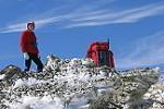
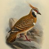
Roger is correct. The top of the old 4WD track from Whites River can be hard to find. I'm tending towards starting at Guthega Power Station, getting the road bashing over. From GPS go up to the crest and the management track goes northish and a minor track goes left, to contour above Horse Camp. Take the latter - less climbing, no wet crossing below Horse Camp. This comes out below Whites River. Up to Schlink Pass. Start going to the left to avoid the rocks and then curve right. This gets you to Dickey Cooper Bogong, lovely open terrain with a few slightly exposed campsites, creeks here and there. Return via the pipes to GPS. Gungartan is a good side-trip, curving to the right, south-east, then NE and north. Avoid the boulder field, very nasty.
The pictures below are in December.
The pictures below are in December.
- Rolling Ground
- Rolling Ground camp
- South from near Dicky Cooper Bogong
-
Lophophaps - Auctorita modica

- Posts: 3475
- Joined: Wed 09 Nov, 2011 9:45 am
- Region: Victoria
- Gender: Male
Re: Multiday walks in Kosciuszko NP
![]() by flea » Thu 06 Jan, 2022 7:00 am
by flea » Thu 06 Jan, 2022 7:00 am
Thanks very much for the tips! Much appreciated.
- flea
- Nothofagus cunninghamii
- Posts: 3
- Joined: Sat 01 Jan, 2022 1:28 pm
- Region: Australian Capital Territory
Re: Multiday walks in Kosciuszko NP
![]() by rcaffin » Thu 06 Jan, 2022 7:26 am
by rcaffin » Thu 06 Jan, 2022 7:26 am
Hi Lop
What's the purple tent? Only two poles?
Cheers
Roger
What's the purple tent? Only two poles?
Cheers
Roger
-
rcaffin - Athrotaxis selaginoides
- Posts: 1308
- Joined: Thu 17 Jul, 2008 3:46 pm
Re: Multiday walks in Kosciuszko NP
![]() by icefest » Thu 06 Jan, 2022 10:30 am
by icefest » Thu 06 Jan, 2022 10:30 am
looks like an old macpac minaret?

Men wanted for hazardous journey. Low wages, bitter cold, long hours of complete darkness. Safe return doubtful.
-

icefest - Lagarostrobos franklinii

- Posts: 4517
- Joined: Fri 27 May, 2011 11:19 pm
- Location: www.canyoninginvictoria.org
- Region: Victoria
Re: Multiday walks in Kosciuszko NP
![]() by Lophophaps » Thu 06 Jan, 2022 12:03 pm
by Lophophaps » Thu 06 Jan, 2022 12:03 pm
Roger, the tent brand is unknown to me; the trip was in 1991. It could be a Minaret. One person was in this tent.
-
Lophophaps - Auctorita modica
- Posts: 3475
- Joined: Wed 09 Nov, 2011 9:45 am
- Region: Victoria
- Gender: Male
Re: Multiday walks in Kosciuszko NP
![]() by rcaffin » Thu 06 Jan, 2022 12:19 pm
by rcaffin » Thu 06 Jan, 2022 12:19 pm
Yes indeed! An old Minaret.
Macpac purple of course.
Cheers
Roger
Macpac purple of course.
Cheers
Roger
-
rcaffin - Athrotaxis selaginoides
- Posts: 1308
- Joined: Thu 17 Jul, 2008 3:46 pm
103 posts
• Page 4 of 4 • 1, 2, 3, 4
Return to New South Wales & ACT
Who is online
Users browsing this forum: No registered users and 5 guests