The map is still 1st edition but a revision occured in 2005. Does anyone know what alterations occurred that justified the reprinting?
And, are the falls to the east of Sarah Jane the famous falls that appear in a beautiful postcard shot by Rob Blakers?
Thanks, Vagrom.
Mt Anne 1/25k map
Forum rules
Tasmania specific bushwalking discussion. Please avoid publishing details of access to sensitive areas with no tracks.
Tasmania specific bushwalking discussion. Please avoid publishing details of access to sensitive areas with no tracks.
14 posts
• Page 1 of 1
-

vagrom - Athrotaxis selaginoides

- Posts: 1002
- Joined: Thu 25 Mar, 2010 10:27 pm
- Location: Adelaide
- ASSOCIATED ORGANISATIONS: WalkingSA, Frnd Cleland/Bushcare, Alltrails
- Region: South Australia
Re: Mt Anne 1/25k map
![]() by Azza » Mon 29 Mar, 2010 11:04 pm
by Azza » Mon 29 Mar, 2010 11:04 pm
Probably ran out of stock. Then they usually reprint them in GDA, hence the minor revision is switching the datum from WGA66 to GDA94.
So you need to be a little careful if your playing with coordinates and GPS'es.
Not sure about the falls, are they Angel falls? There is a thread somewhere here on the forum regarding them.
Cheers
Aaron
So you need to be a little careful if your playing with coordinates and GPS'es.
Not sure about the falls, are they Angel falls? There is a thread somewhere here on the forum regarding them.
Cheers
Aaron
-

Azza - Phyllocladus aspleniifolius

- Posts: 979
- Joined: Thu 06 Mar, 2008 11:26 am
Re: Mt Anne 1/25k map
![]() by eggs » Tue 30 Mar, 2010 8:57 am
by eggs » Tue 30 Mar, 2010 8:57 am
Yes - we talked a bit about it at http://bushwalk.com/forum/viewtopic.php?f=3&t=1179&p=10754&hilit=impression+of+the+falls#p10754
This links to a web photo of the falls - I am not familiar with the postcard you mention, but I have seen a calendar shot of it ages ago.
This links to a web photo of the falls - I am not familiar with the postcard you mention, but I have seen a calendar shot of it ages ago.
-

eggs - Lagarostrobos franklinii

- Posts: 10856
- Joined: Fri 23 May, 2008 2:58 pm
- Location: Para Vista, South Australia
- Region: South Australia
Re: Mt Anne 1/25k map
![]() by luke_vic » Tue 30 Mar, 2010 7:46 pm
by luke_vic » Tue 30 Mar, 2010 7:46 pm
slightly off topic but didn't think a new topic was justified:
Am looking at doing the Mt Anne Circuit, and I had a question about which direction to set out on. It sounds like an anti-clockwise loop is not common. Is it worth considering this direction or is it better going the standard way?
Cheers
luke_vic
Am looking at doing the Mt Anne Circuit, and I had a question about which direction to set out on. It sounds like an anti-clockwise loop is not common. Is it worth considering this direction or is it better going the standard way?
Cheers
luke_vic
- luke_vic
- Atherosperma moschatum

- Posts: 79
- Joined: Mon 18 Aug, 2008 6:38 pm
Re: Mt Anne 1/25k map
![]() by dee_legg » Tue 30 Mar, 2010 8:01 pm
by dee_legg » Tue 30 Mar, 2010 8:01 pm
Most people would say that it's easier to go push down through the scrub on the ridge off Sarah Jane than go up through it.
-

dee_legg - Athrotaxis cupressoides

- Posts: 447
- Joined: Mon 01 Oct, 2007 4:12 pm
- Location: Hobart
- Region: Tasmania
- Gender: Female
Re: Mt Anne 1/25k map
![]() by samh » Wed 31 Mar, 2010 8:08 am
by samh » Wed 31 Mar, 2010 8:08 am
aljscott wrote:Probably ran out of stock. Then they usually reprint them in GDA, hence the minor revision is switching the datum from WGA66 to GDA94.
So you need to be a little careful if your playing with coordinates and GPS'es.
Not sure about the falls, are they Angel falls? There is a thread somewhere here on the forum regarding them.
Cheers
Aaron
I'm actually not sure if they have switched from AGD66 to GDA 94 unless the map has also the new blue-black cover, even though they are reprinted as long as it's still the yellow cover its AGD66. I have a map (Glovers reprinted 2006) but it's still AGD66
- samh
- Athrotaxis cupressoides
- Posts: 257
- Joined: Mon 02 Mar, 2009 9:12 pm
- Region: Tasmania
Re: Mt Anne 1/25k map
![]() by wander » Wed 31 Mar, 2010 11:00 am
by wander » Wed 31 Mar, 2010 11:00 am
I did not see any issues when we did the Mt Anne wander anti-clockwise. We did not notice the scrub going the wrong way while climbing up to the plateu. Probably because it started raining just as we left Lake Judd camp and the track up was in fact a flowing creek / waterfall as so we were distracted by water rather than the scrub. Most in our party (4) felt they would rather go down the large scree (as we were doing) off Mt Anne than climb it.
- wander
- Phyllocladus aspleniifolius
- Posts: 943
- Joined: Mon 26 Oct, 2009 11:19 am
- Region: South Australia
- Gender: Male
Re: Mt Anne 1/25k map
![]() by luke_vic » Wed 07 Apr, 2010 12:54 pm
by luke_vic » Wed 07 Apr, 2010 12:54 pm
Thanks for the info all.
Just returned from doing the Anne circuit in the clockwise direction and all went well. Challenging but rewarding!
One thing that did take me by surprise was a scrambling section after the notch that was harder than the notch itself! Does anyone know much about this? It wasn't far from the top of Mt Lot. After closer inspection of the track notes it sounds like there is a way around this section. Can anyone cofirm this? Is there and easier way around??? Not sure I'd tempt fate by doing this bit again!!!
Cheers
luke_vic
- luke_vic
- Atherosperma moschatum
- Posts: 79
- Joined: Mon 18 Aug, 2008 6:38 pm
Re: Mt Anne 1/25k map
![]() by rohjoe » Wed 07 Apr, 2010 9:29 pm
by rohjoe » Wed 07 Apr, 2010 9:29 pm
I seem to recall a scree slope a bit further along from the narrow scrambly section, which is easier to ascend. Others might have more detail on this.
-

rohjoe - Athrotaxis cupressoides
- Posts: 106
- Joined: Fri 04 Jan, 2008 8:40 pm
- Region: Tasmania
Re: Mt Anne 1/25k map
![]() by luke_vic » Sat 10 Apr, 2010 9:12 am
by luke_vic » Sat 10 Apr, 2010 9:12 am
Thanks rohjoe, I thought there might be an easier way. Does anyone have photos / more info on this section?
- luke_vic
- Atherosperma moschatum
- Posts: 79
- Joined: Mon 18 Aug, 2008 6:38 pm
Re: Mt Anne 1/25k map
![]() by vagrom » Wed 28 Apr, 2010 11:18 pm
by vagrom » Wed 28 Apr, 2010 11:18 pm
In clarifying and still interested to know as it may help to understand tasmap policy, i've got the Anne map with me and under the heading ANNE it says, "Reprinted with minor amendments in 2005 from 1989 original plates".
The datum is still AGD 1966. and info at the top right corner says "Sheet 4424 Edition 1 1989 "
" Minor amendments" might mean one of two things: incorrect information on the first printing or, that things like track routing have altered.
The datum is still AGD 1966. and info at the top right corner says "Sheet 4424 Edition 1 1989 "
" Minor amendments" might mean one of two things: incorrect information on the first printing or, that things like track routing have altered.
Surgite et .. andiamo!
-
vagrom - Athrotaxis selaginoides
- Posts: 1002
- Joined: Thu 25 Mar, 2010 10:27 pm
- Location: Adelaide
- ASSOCIATED ORGANISATIONS: WalkingSA, Frnd Cleland/Bushcare, Alltrails
- Region: South Australia
Re: Mt Anne 1/25k map
![]() by vagrom » Wed 28 Apr, 2010 11:22 pm
by vagrom » Wed 28 Apr, 2010 11:22 pm
Oh Strewth, perhaps I meant Preview instead of Save. It's disappeared from view, but hopefully this bit will follow on.
The best known track re-routing I know of is the one that allowed bypassing of Judds Cavern Wargata Mina on the way to Moss Ridge and I can't remember if a fresh map has since come out for that. Perhaps it's the Burgess map?
Someone might know if, on average, when Tasmap notes something like that, useing the term "amendments" instead of "revisions", it is usually going to refer to a change rather than a correction. Walking with knowledgeable Taswegians has yeilded such useful information about local conditions in the past.
I note that no "Special" map has ever been produced for the Anne circuit and presume this can only be because it might suggest its quite a good jaunt when from personal experience over several visits, it is most decidedly not. I've haven't tried the circuit on my own but when the sturm und drang comes in, especially at Shelf Camp, then Code Brown is the order of the day. To go on towards Lightening Ridge in such weather, as a first timer, has to be worrying. But if one knows the route well and wants to get down to the Lakes and protection, then perhaps it's okay. When I read people asking here for any tips and see no mention of Shelf Camp, I swallow.
But it has to be one of the best tests for a tent in Australia. My Microlight has come through well. It's Chapman I think, who rightly refers to wind coming from the north. Last time they broke one of the poles on our Sierra Leone(Salewa). As the highest peak in the south west (1444m?), the views and the feeling is very special, the little memorial plaque near the Notch is sobering. A smallgroup is really a must, with enough eyes to seek out the cairns.
More still to say about beautiful Anne but type too slowly. Gowlland says there was once consideration given to running a rail line underneath it, out to Port Davey I think.
The best known track re-routing I know of is the one that allowed bypassing of Judds Cavern Wargata Mina on the way to Moss Ridge and I can't remember if a fresh map has since come out for that. Perhaps it's the Burgess map?
Someone might know if, on average, when Tasmap notes something like that, useing the term "amendments" instead of "revisions", it is usually going to refer to a change rather than a correction. Walking with knowledgeable Taswegians has yeilded such useful information about local conditions in the past.
I note that no "Special" map has ever been produced for the Anne circuit and presume this can only be because it might suggest its quite a good jaunt when from personal experience over several visits, it is most decidedly not. I've haven't tried the circuit on my own but when the sturm und drang comes in, especially at Shelf Camp, then Code Brown is the order of the day.
But it has to be one of the best tests for a tent in Australia. My Microlight has come through well. It's Chapman I think, who rightly refers to wind coming from the north. Last time they broke one of the poles on our Sierra Leone(Salewa). As the highest peak in the south west (1444m?), the views and the feeling is very special, the little memorial plaque near the Notch is sobering. A smallgroup is really a must, with enough eyes to seek out the cairns.
More still to say about beautiful Anne but type too slowly. Gowlland says there was once consideration given to running a rail line underneath it, out to Port Davey I think.
Surgite et .. andiamo!
-
vagrom - Athrotaxis selaginoides
- Posts: 1002
- Joined: Thu 25 Mar, 2010 10:27 pm
- Location: Adelaide
- ASSOCIATED ORGANISATIONS: WalkingSA, Frnd Cleland/Bushcare, Alltrails
- Region: South Australia
Re: Mt Anne 1/25k map
![]() by luke_vic » Sun 06 Jun, 2010 5:39 pm
by luke_vic » Sun 06 Jun, 2010 5:39 pm
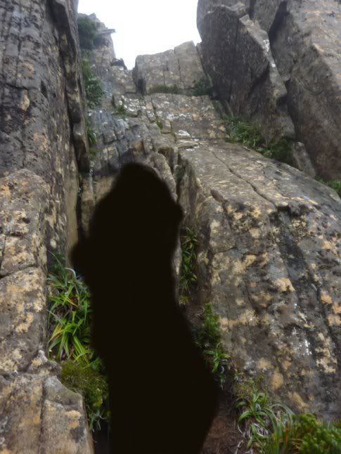
luke_vic wrote:One thing that did take me by surprise was a scrambling section after the notch that was harder than the notch itself! Does anyone know much about this? It wasn't far from the top of Mt Lot.
Okay, to further clarify, i found this photo on the web (google) of the section I'm talking about. This is not my photo so I have blanked out the person in frame. Are people familiar with this section? Is there a way around?
- luke_vic
- Atherosperma moschatum
- Posts: 79
- Joined: Mon 18 Aug, 2008 6:38 pm
Re: Mt Anne 1/25k map
![]() by Vern » Mon 07 Jun, 2010 12:08 pm
by Vern » Mon 07 Jun, 2010 12:08 pm
I know the section and didn't look for a way around but if you pack haul then it should be ok. I climbed it with the pack on and still got up there. Would recomend pack hauling though.
I agree that this climb was harder than the notch itself. I think the notch is more of an exposure issue with the steep drops off to the side playing on your mind a bit.
Flickr search for "shelf camp sunrise" or "the notch mt anne" and you should find them. Photo by Vern and Skeet.I posted 2 groups of pics on Flickr for the Mt Anne circuit if anyone is interested. An amazing walk HIGHLY recommended!
-
Vern - Athrotaxis cupressoides
- Posts: 246
- Joined: Sat 05 Jun, 2010 11:28 am
- Location: Penriff, NSW
- Region: Tasmania
- Gender: Male
14 posts
• Page 1 of 1
Who is online
Users browsing this forum: Bing [Bot] and 42 guests