The east coast fires were 2020. In the first year or so afterward, walking was easy in many places as the scrub was burnt. By 2021, the bush was regrowing really thickly and I had trips where my clothes were ripped to shreds (literally) and my pace was about 1 km per hour. Since then, things may have got worse, I think, certainly not better. The regrowth that was waist high is now 3 metres high and progress is made by tunneling through like a rabid wombat. Sometimes even managing a kilometre an hour is actually fast.
What are people's opinions on when the forests will return to more open large trees with minimal understory? Will it be decades? Will it be never? Are some tracks gone for good? Some areas got very little traffic before the fires and probably much less now; after all, who actually enjoys bashing through at a km/hour as your clothes get shredded?
There are not many reports on the forums here, but what reports there are talk about pretty rough conditions on routes that were passable before the fires.
Interested in any and all opinions.
Post Fire Regrowth
Forum rules
The place for bushwalking topics that are not location specific.
The place for bushwalking topics that are not location specific.
34 posts
• Page 1 of 2 • 1, 2
Post Fire Regrowth
![]() by sandym » Wed 14 Jun, 2023 4:16 pm
by sandym » Wed 14 Jun, 2023 4:16 pm
- sandym
- Phyllocladus aspleniifolius

- Posts: 657
- Joined: Wed 19 Sep, 2012 7:34 pm
- Region: New South Wales
- Gender: Female
Re: Post Fire Regrowth
![]() by crollsurf » Wed 14 Jun, 2023 7:31 pm
by crollsurf » Wed 14 Jun, 2023 7:31 pm
Yes, yes, maybe, yes/maybe.
I've bleated about this to a few friends. As I understand it in NSW, the NPWS have almost no budget for trail maintenance. They're spending big using grants from the government.
In fact, some NPWS staff have been led to believe NPWS needs to become a profit centre! Imagine that, a government department that makes a profit!
NPA have daily walks, but they seem to be focused on being a "good cop" and defending the environment.
Any groups that represent our interests have no political representation that I'm aware of.
Longer term, that impenetrable scrub will give way to more open environments, but that'll take decades. And that also depends on science winning over short sightedness. Politicans want votes.
Most ecologies produce bigger fuel loads when burnt regularly, not less. And you're seeing that now. The country needs a rest from regular burns and to get back to a fire resilient equilibrium.
Sent from my SM-G998B using Tapatalk
-

crollsurf - Lagarostrobos franklinii

- Posts: 2317
- Joined: Tue 07 Mar, 2017 10:07 am
- Location: Sydney
- Region: New South Wales
- Gender: Male
Re: Post Fire Regrowth
![]() by headwerkn » Thu 15 Jun, 2023 10:53 am
by headwerkn » Thu 15 Jun, 2023 10:53 am
Depends on the environment obviously, but here in Tassie the answer is definitely in the 'decades' category. Most of the areas in the south-west burned in 2018-2019 will regenerate *very* slowly. The fear is of course that meaningful regen won't occur before the next fire comes through.
Agreed, the only thing more depressing than walking through burned out areas is walking through burnt out areas full of rapid understorey growth that hides the pad
Agreed, the only thing more depressing than walking through burned out areas is walking through burnt out areas full of rapid understorey growth that hides the pad
-
headwerkn - Phyllocladus aspleniifolius
- Posts: 661
- Joined: Sat 09 Nov, 2013 3:50 pm
- Region: Tasmania
- Gender: Male
Re: Post Fire Regrowth
![]() by puredingo » Fri 16 Jun, 2023 11:47 am
by puredingo » Fri 16 Jun, 2023 11:47 am
Mate! I’m hearing and feeling you on all levels. In late 2020 I suffered a terrible tragedy in my life that drove me to spending an extraordinary amount of time bushwalking. And I seen it all; from the freewheeling romps of the post burn where, besides being coloured-in with charcoal, you could burn up the kilometres totally unimpeded with the view uninterrupted.
Then the regrowth beginning at knee height which was doable and pleasant to see some colour again, then waist to shoulder became kinda annoying and also it was also noticeable that the nice grassy flats over a lot of river banks are being grown out and not going to make it. And then well over head height, nightmare.
Over the next 2 years I wrecked a lot of good gear battling that almost impenetrable scrub and what didn’t break I lost due to the nature of falls and hang up’s and heavy fatigue. My body suffered the most; I believe such was the arduous effort put into some of those walks it probably put 10 years of wear on my joints to where I should be. In March I did my final one. I quit.
So just last weekend I did a 3 day loop in the Jagungal Mountains, I passed a mob of local walkers and they asked how I was dealing with the hills and climate of the place? I answered “clear but cool weather with the sun out…a water source every 20 minutes and a defined fire trail with signs!” Coping nicely, I said.
So I’m not sure of the scientific solution to this bar another fire but I’m done until it sorts itself out that for sure….
- puredingo
- Athrotaxis selaginoides

- Posts: 1326
- Joined: Mon 13 Feb, 2012 6:54 am
- Region: New South Wales
Re: Post Fire Regrowth
![]() by sandym » Sun 18 Jun, 2023 12:53 pm
by sandym » Sun 18 Jun, 2023 12:53 pm
Puredingo:
I am fast approaching that point, although to date all my joints are holding up. I've always enjoyed the more off the beaten track places which is why I am always, like you, out there bashing away through the bush. Conditions now, at least in a lot of places I have been to are at best 1 km of travel per hour, sometimes less. So 10 kilometres a day, an insignificant amount for most bushwalkers, now might take 10 hours!
The other thing I noticed from my last weekend out there bashing about was how unrewarding it all felt now. There are so few views due to scrub so you might walk all day and get just a glimpse of something and hopefully, find somewhere you can put up a tent for the night. Otherwise, you spend all day staring at the compass and trying to stay on track as you swim, struggle, bash, beat through the bush.
Last weekend I finally admitted, I'm never going back to some of those areas in the Deau. I'm 60 now and if it takes ten or twenty years for the bush to improve, I'll be too old for that malarky.
Very few people have commented but I am interested in how many bushwalkers are continuing to fight the good fight?
- sandym
- Phyllocladus aspleniifolius
- Posts: 657
- Joined: Wed 19 Sep, 2012 7:34 pm
- Region: New South Wales
- Gender: Female
Re: Post Fire Regrowth
![]() by Walk_fat boy_walk » Mon 19 Jun, 2023 11:50 am
by Walk_fat boy_walk » Mon 19 Jun, 2023 11:50 am
It's definitely curbed my enthusiasm for off-track walking and a lot of the areas I used to frequent are, frankly, not worth the effort now for the below reasons. Even a lot of the old tracks are now no longer present in places, eg. the various access routes to the Kowmung from Kanangra are now anecdotally so much of a scrub bash that they're no longer enjoyable? Following watercourses (at times in them) is always an option so places like Ettrema are still viable if using creeks (eg. Bullfrog, Myall, Cinch) as entry/exit points instead of the now scrub-choked spurs. Same with the northern Budawangs. And not all off-track walking is affected... snowys etc are still ok. But yeah for the time being most walking will be on tracks that haven't been ruined/significantly obscured by fire regrowth, which is a bit limiting.
- Walk_fat boy_walk
- Lagarostrobos franklinii
- Posts: 2354
- Joined: Sat 21 Nov, 2009 6:59 am
- Gender: Male
Re: Post Fire Regrowth
![]() by crollsurf » Mon 19 Jun, 2023 2:45 pm
by crollsurf » Mon 19 Jun, 2023 2:45 pm
Even the on tracks in the Budawangs are disappearing. And like you mention, not even the ridgelines are an escape from the scrub anymore.
Sent from my SM-G998B using Tapatalk
Sent from my SM-G998B using Tapatalk
-
crollsurf - Lagarostrobos franklinii
- Posts: 2317
- Joined: Tue 07 Mar, 2017 10:07 am
- Location: Sydney
- Region: New South Wales
- Gender: Male
Re: Post Fire Regrowth
![]() by Biggles » Mon 19 Jun, 2023 4:33 pm
by Biggles » Mon 19 Jun, 2023 4:33 pm
IN THE FAR North-east of Victoria, Burrowa-Pine Mountain National Park did not escape the infernal conflagration of 2020. The fires roared north, engulfing much of the Alpine National Park area, and destroyed the townships of Cudgewa, Walwa and parts of Shelly on the way to the Park. There were farms standing in harm's way when the fires moved. The human cost was far greater than the loss of the natural environment within the Park.
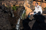
I have kept in touch with the Ranger Team Leader who oversees work at BPMNP. Repatriation works are ongoing, and dependent on funding and labour availability. There are still the gaunt, blackened skeletons of trees that harken to a bleak time. The lower areas, particularly around Bluff Creek, and including the (reconstructed) Bluff Creek Nature Walk (starting from the Bluff Creek Picnic/Camping area), have repopulated with vigorous native regrowth. Bluff Creek, slightly altered in its course from bushfire then calamitous floods last October, has had stabilisation blocks placed along its sides. Two footbridges at the terminus of Bluff Creek Nature Walk have been replaced, along with steps up to the car park access road. There is currently no access to the (destroyed) balcony overlooking Bluff Falls (aka Cudgewa Bluff Falls), visible now only from the very end of the access track from the car park. It is expected that completion of the vast amount of repatriation will be finished by next autumn (2024).
The photo shows this remote beauty spot how its seldom seen features was like almost 20 years ago. Of course, no lichen nor moss festoons the ancient rock, nor the chute leaping heroically from the chasm into the meandering stream below.
- Attachments
-
- Chute on Bluff Creek, Burrowa-Pine Mountain National Park, Victoria. 2004. Ilfochrome Classic CPSK1 print. In private collection.
Conversation about the weather is the last refuge of the unimaginative.
—Oscar Wilde, 1890.
—Oscar Wilde, 1890.
-

Biggles - Phyllocladus aspleniifolius
- Posts: 512
- Joined: Thu 14 May, 2009 12:14 pm
- Location: Castlemaine & Geelong
- Region: Victoria
- Gender: Male
Re: Post Fire Regrowth
![]() by johnw » Mon 19 Jun, 2023 5:50 pm
by johnw » Mon 19 Jun, 2023 5:50 pm
crollsurf wrote:As I understand it in NSW, the NPWS have almost no budget for trail maintenance. They're spending big using grants from the government.
In fact, some NPWS staff have been led to believe NPWS needs to become a profit centre! Imagine that, a government department that makes a profit!
Longer term, that impenetrable scrub will give way to more open environments, but that'll take decades. And that also depends on science winning over short sightedness. Politicans want votes.
Most ecologies produce bigger fuel loads when burnt regularly, not less. And you're seeing that now. The country needs a rest from regular burns and to get back to a fire resilient equilibrium.
Yeah, the previous Liberal NSW govt was all about making a dollar out of our public assets at the expense of the people it served, and reacting to its anti-environment backers. It remains to be seen if the new Labor govt. will have a more positive influence but they arguably have a better environmental record (though it's not hard to beat the previous incumbents).
I haven't done a lot of off track stuff in recent years other than some volunteer trips. Some of those have been through fire grounds incinerated in the 2019/20 conflagration. I traversed the ashen remains of one location once we were able to get back in there soon after the fires, and it was like a black desert. Nothing hindering progress except fallen tree trunks and stumps of charcoal. I was back at the same spot late last year and the amount of regrowth was next level. It was tough going and I wouldn't normally consider tramping through it. Probably much worse by now.
I don't think the fires are the only factor. The amount of rain post fires, whether on burnt or untouched ground I think has had a big impact. For example I live a short walk from some nice but degraded riparian bushland reserves where there are virtually no formal tracks. Just occasional pads through the bush, or make it up as you go. There is one reasonably well defined pad that I've often walked in past. I hadn't been through that spot for many months and last week I hit a figurative brick wall when I lost the track completely at a junction that I know well. Recent growth had completely obscured the way forward and it took me 10 minutes to figure out the way through.
Second hand info but my son does quite a few weekend overnight trips. He has frequently told me in recent times of tracks that were previously easily traversed but now obscured. A few weeks ago he went from Dunphys campground to Splendour Rock. I asked if he went via Carlon Creek and Black Horse Ridge as I'd done that trip with him many years ago using that route and remembered it as being pretty good. The answer was that Black Horse Ridge is no longer traversable.
Like others have said I think I'll be sticking to well trodden tracks from now on, or up in the alpine areas post winter where it's easier to make progress. I'm getting too old to spend most of my time bush bashing.
John W
In Nature's keeping they are safe, but through the agency of man destruction is making rapid progress - John Muir c1912
In Nature's keeping they are safe, but through the agency of man destruction is making rapid progress - John Muir c1912
-
johnw - Lagarostrobos franklinii
- Posts: 9685
- Joined: Wed 23 Jan, 2008 11:59 am
- Location: Macarthur Region - SW Sydney
- Region: New South Wales
- Gender: Male
Re: Post Fire Regrowth
![]() by puredingo » Thu 22 Jun, 2023 9:23 am
by puredingo » Thu 22 Jun, 2023 9:23 am
I guess the reason why this post has had so few stories of woe pertaining to the impenetrable state of our local bushwalking tracks is, I think, due to this; why would you?
Unless, like myself, you have a certain intrinsic link to these places such as sentimental value or reasons of nostalgia or you have a history in the region and curiosity drives you see it’s current condition and hoping it’s fared well…people just wouldn’t bother.
And to be fair I never really seen anybody, bar the occasional sign of people, in those areas when there once was a track. So a couple of horror story trip reports and a lot of negative word of mouth basically means zero population to open these forgotten tracks back up.
It’s a terrible shame.
- puredingo
- Athrotaxis selaginoides
- Posts: 1326
- Joined: Mon 13 Feb, 2012 6:54 am
- Region: New South Wales
Re: Post Fire Regrowth
![]() by Huntsman247 » Thu 22 Jun, 2023 8:25 pm
by Huntsman247 » Thu 22 Jun, 2023 8:25 pm
Late to the party here but my enthusiasm has also been curbed.
Regrowth has been immense in most places.
I've also found that revisiting locations post fires and seeing the damage from the fires and floods has been rather depressing. As these places won't look the same for many decades if ever. Especially the hard hit places which is most of the Budawangs. I haven't had the heart to visit the rock ribs since the fires.
Heading there for the first time since this weekend.
Personally from what I've seen, the fire was so intense that many places will take a very very long time to recover. And all the dead burnt trees still standing... Preserved for a long time.
I just did a trip into hollands gorge from folly point last week. Not many people visiting the area since prefire times.
In the past, the route from Watson's was basically a pad. It didn't exist anymore beyond fallen cairns.
I saw evidence of another group but only up to the CC. I was quite happy to not need to smash down the insane growth of sword grass and scrub straight from the start.
The vine growth, fallen trees and head high weeds are a nightmare. I've never needed to use my knife so much.
Then the amount of drift wood washed into the creeks don't make it easy as before. It's especially bad until hollands.
Took hours but I've cleared the falls limbs and cut a path through the vines on the route pretty good so if anyone wants an 'easier' trip, now would be the time. Lol.
I've done that route many times and it's never taken me so long.
In 2022, I did a trip into the upper part of hollands creek. 4hrs for 700m to get out onto styles swamp. That was a record for me and I was going hard.
I'm learning that if planning to go offtrack I've got to plan for only 5-8k per day to be on the safe side when going with a group. It's just too slow going.
-
Huntsman247 - Phyllocladus aspleniifolius
- Posts: 591
- Joined: Wed 22 Mar, 2017 10:07 pm
- Region: New South Wales
- Gender: Male
Re: Post Fire Regrowth
![]() by Walk_fat boy_walk » Fri 23 Jun, 2023 8:21 am
by Walk_fat boy_walk » Fri 23 Jun, 2023 8:21 am
Might just take you up on thatHuntsman247 wrote:Took hours but I've cleared the falls limbs and cut a path through the vines on the route pretty good so if anyone wants an 'easier' trip, now would be the time. Lol.
- Walk_fat boy_walk
- Lagarostrobos franklinii
- Posts: 2354
- Joined: Sat 21 Nov, 2009 6:59 am
- Gender: Male
Re: Post Fire Regrowth
![]() by sandym » Fri 23 Jun, 2023 3:54 pm
by sandym » Fri 23 Jun, 2023 3:54 pm
Huntsman:
How far does your "clearing" go?
That is one route I have yet to do in the Budawangs and I might be enticed out one more time (no doubt to come back wondering why).
How far does your "clearing" go?
That is one route I have yet to do in the Budawangs and I might be enticed out one more time (no doubt to come back wondering why).
- sandym
- Phyllocladus aspleniifolius
- Posts: 657
- Joined: Wed 19 Sep, 2012 7:34 pm
- Region: New South Wales
- Gender: Female
Re: Post Fire Regrowth
![]() by Huntsman247 » Fri 23 Jun, 2023 5:28 pm
by Huntsman247 » Fri 23 Jun, 2023 5:28 pm
sandym wrote:Huntsman:
How far does your "clearing" go?
That is one route I have yet to do in the Budawangs and I might be enticed out one more time (no doubt to come back wondering why).
Hahaha.
I tried to further establish the trail through to the CC as best I could. It may be a bit hard to find in some spots but I could PM you a gpx file to assist in stomping down the trail some more. But that would be relativity 'easy' going now. Just steep but a well stomped path.
From the CC, I've cut through the vines and shifted as much fallen timber that I could repairing Cairns as I went along. There was 4 of us in the group and we definitely left a trail behind us. Going in and back out. Gpx file could help you stay on our route. It's no footpad but defs a bit of a trail until dropping into the creek. From the creek you'll have to navigate the grass, ferns and washed in dead timber/trees into camping rock ck up to hollands. We made a dent but I wasn't trying to make a trail there as we were running out of day light coming in and going out I was trying to stay dry. That's probably the hardest bit left as there are a lot of fallen trees.
It took us about 8 hrs to get only to hollands ck from the campsite at Watson's pass. It will probably be quicker now and we did have a newbie but depending on how fast you walk... I would still allow for a similar time frame.
-
Huntsman247 - Phyllocladus aspleniifolius
- Posts: 591
- Joined: Wed 22 Mar, 2017 10:07 pm
- Region: New South Wales
- Gender: Male
Re: Post Fire Regrowth
![]() by puredingo » Fri 23 Jun, 2023 6:37 pm
by puredingo » Fri 23 Jun, 2023 6:37 pm
Maybe this is a solution to our problem?
Each month a member gets to nominate a track and in that ensuing month we all have to visit that track at our convenience and walk it while we remediate.
By 2040 we should have about 4 tracks completed
Each month a member gets to nominate a track and in that ensuing month we all have to visit that track at our convenience and walk it while we remediate.
By 2040 we should have about 4 tracks completed
- puredingo
- Athrotaxis selaginoides
- Posts: 1326
- Joined: Mon 13 Feb, 2012 6:54 am
- Region: New South Wales
Re: Post Fire Regrowth
![]() by Huntsman247 » Fri 23 Jun, 2023 9:51 pm
by Huntsman247 » Fri 23 Jun, 2023 9:51 pm
puredingo wrote:Maybe this is a solution to our problem?
Each month a member gets to nominate a track and in that ensuing month we all have to visit that track at our convenience and walk it while we remediate.
By 2040 we should have about 4 tracks completed
Hahahaha
Someone else can cut the next trail. Lol
-
Huntsman247 - Phyllocladus aspleniifolius
- Posts: 591
- Joined: Wed 22 Mar, 2017 10:07 pm
- Region: New South Wales
- Gender: Male
Re: Post Fire Regrowth
![]() by sandym » Sat 24 Jun, 2023 2:28 pm
by sandym » Sat 24 Jun, 2023 2:28 pm
Huntsman, I'll DM you for a gpx file and will attempt to get in there the next couple of weeks. You took a newby! Bit of a baptism by fire.
This site might be useful, it shows how "hot" the fire burned. It almost seems as if the areas where the fires were really intense are worst affected by regrowth, although I have yet to test that theory using the information on the web site.
https://geo.seed.nsw.gov.au/Public_Viewer/index.html?viewer=Public_Viewer&locale=en-AU&runWorkflow=AppendLayerCatalog&CatalogLayer=SEED_Catalog.331.2019-20%20FESM%20Severity%20Classes
- sandym
- Phyllocladus aspleniifolius
- Posts: 657
- Joined: Wed 19 Sep, 2012 7:34 pm
- Region: New South Wales
- Gender: Female
Re: Post Fire Regrowth
![]() by peregrinator » Sat 24 Jun, 2023 5:55 pm
by peregrinator » Sat 24 Jun, 2023 5:55 pm
sandym wrote:Huntsman, I'll DM you for a gpx file and will attempt to get in there the next couple of weeks. You took a newby! Bit of a baptism by fire.
This site might be useful, it shows how "hot" the fire burned. It almost seems as if the areas where the fires were really intense are worst affected by regrowth, although I have yet to test that theory using the information on the web site.
https://geo.seed.nsw.gov.au/Public_Viewer/index.html?viewer=Public_Viewer&locale=en-AU&runWorkflow=AppendLayerCatalog&CatalogLayer=SEED_Catalog.331.2019-20%20FESM%20Severity%20Classes
Yes, seems very useful. But very depressing.
When viewing it, would there be a way to quickly alternate between switching the fire severity data on and off? It's impossible to see most of the underlying positional information.
- peregrinator
- Athrotaxis selaginoides
- Posts: 1860
- Joined: Fri 15 Apr, 2011 2:50 pm
- Region: Victoria
Re: Post Fire Regrowth
![]() by Phillip » Sat 24 Jun, 2023 9:14 pm
by Phillip » Sat 24 Jun, 2023 9:14 pm
See my post from October last year for a report on Kanangra down Gingra up Ti Willa and return.
https://bushwalk.com/forum/viewtopic.ph ... ra#p437250
https://bushwalk.com/forum/viewtopic.ph ... ra#p437250
- Phillip
- Nothofagus cunninghamii

- Posts: 6
- Joined: Sun 25 Sep, 2022 5:43 pm
- Region: New South Wales
- Gender: Male
Re: Post Fire Regrowth
![]() by Mechanic-AL » Sun 25 Jun, 2023 11:39 am
by Mechanic-AL » Sun 25 Jun, 2023 11:39 am
I know nothing of the science behind all this. But like others here I do know what I see with my eyes. I have been riding my bike to work for well over 12 years now. I follow the old railway line through Jarrah and Marri forest north of Margaret River. Every years large sections of this track get burnt. There are some sections of the track now that are so choked with vines and weeds that I will soon be riding through a tunnel. Im not entirely against burning but the way these guys fire it up is almost criminal. Burnt out limbs 20 metres in the air are not the result of a well managed burn. Ive seen stumps and logs still smouldering months after a "controlled" burn. On more than one occassion Ive put Bobtailled Skinks that are on there last legs into my backpack and moved then to safer locations after a burn,
Im reasonably sure that light well managed burns can be of benefit. Large scale torching of valuable habit is publicly funded vandalism.
Im reasonably sure that light well managed burns can be of benefit. Large scale torching of valuable habit is publicly funded vandalism.
"What went ye out into the wilderness to see?
A reed shaken in the wind"?
A reed shaken in the wind"?
- Mechanic-AL
- Athrotaxis cupressoides

- Posts: 432
- Joined: Tue 24 Sep, 2013 7:38 pm
- Region: Western Australia
- Gender: Male
Re: Post Fire Regrowth
![]() by johnw » Sun 25 Jun, 2023 1:54 pm
by johnw » Sun 25 Jun, 2023 1:54 pm
peregrinator wrote:When viewing it, would there be a way to quickly alternate between switching the fire severity data on and off? It's impossible to see most of the underlying positional information.
peregrinator, I've figured out how to do that.
1. Zoom in to the area of interest (you could also do that after the following steps).
2. Click "I want to...".
3. Select "Change visible map layers".
4. Either uncheck "FESM" which switches off the layer completely, or adjust the slider near it to the level of opacity required.
John W
In Nature's keeping they are safe, but through the agency of man destruction is making rapid progress - John Muir c1912
In Nature's keeping they are safe, but through the agency of man destruction is making rapid progress - John Muir c1912
-
johnw - Lagarostrobos franklinii
- Posts: 9685
- Joined: Wed 23 Jan, 2008 11:59 am
- Location: Macarthur Region - SW Sydney
- Region: New South Wales
- Gender: Male
Re: Post Fire Regrowth
![]() by sandym » Sun 25 Jun, 2023 5:37 pm
by sandym » Sun 25 Jun, 2023 5:37 pm
John W. Excellent. Had not worked that out myself.
Sandy
Sandy
- sandym
- Phyllocladus aspleniifolius
- Posts: 657
- Joined: Wed 19 Sep, 2012 7:34 pm
- Region: New South Wales
- Gender: Female
Re: Post Fire Regrowth
![]() by crollsurf » Sun 25 Jun, 2023 8:42 pm
by crollsurf » Sun 25 Jun, 2023 8:42 pm
The history of the term "wilderness" is an interesting one, at least in NSW. Originally, it meant an area protected from development.
These days, roads, electricity, etc. can just trample through these areas, feral animals...
But it is a convenient excuse to do nothing when it comes to providing access to people who want to experience these so-called wilderness areas. Which was the original intention.
Contractors, most Rangers aren't going to care if you recut a track. Some would be silently supportive. But there is definitely the chance you'll come across some do-gooder or someone who supports keeping the humans out ( which I'm not totally against)
But this is where it gets difficult. I've never used a machete before! and people slashing through the bush, unless properly informed, are going to lose the original track, ect, injure themselves...
But to get Parks involved, you're talking white cards, training courses, consultants... did someone mention 2040. That sounds about right.
Personally, I'd say recut the track but maybe not the first 40 metres. Recut that last, so no one is aware until it's all said and done.
Sent from my SM-G998B using Tapatalk
-
crollsurf - Lagarostrobos franklinii
- Posts: 2317
- Joined: Tue 07 Mar, 2017 10:07 am
- Location: Sydney
- Region: New South Wales
- Gender: Male
Re: Post Fire Regrowth
![]() by Warin » Mon 26 Jun, 2023 10:39 am
by Warin » Mon 26 Jun, 2023 10:39 am
crollsurf wrote:The history of the term "wilderness" is an interesting one, at least in NSW. Originally, it meant an area protected from development.
Go back further ... it meant 'waste land'. Land that could not be used for anything.
-

Warin - Athrotaxis selaginoides
- Posts: 1467
- Joined: Sat 11 Nov, 2017 8:02 am
- Region: New South Wales
Re: Post Fire Regrowth
![]() by sandym » Mon 26 Jun, 2023 12:57 pm
by sandym » Mon 26 Jun, 2023 12:57 pm
All great points Crollsurf and I must admit that while I support the concept of wilderness, I also think that some wilderness areas would not be harmed by a few low impact trails. More like foot pads, not trails like the new Cape to Cape track but the old footpads that existed before the last fires came through.
There does seem to a false dichotomy introduced into "wilderness areas" where no trails or signage or even cairns are allowed and yet everywhere else (or almost everywhere) the policy makers seem to think it is important to have a parking lot and road every half a kilometre. New trail development seems to require a much higher standard of construction than old trails. For example, the new Murramarang track is wonderful, but it is built to a pretty high standard in places, and the plans to refurbish/upgrade the Light to Light walk verge on - or are - overkill.
Perhaps it is the new age where there is no middle ground. Sometimes it feels as if the casual bushwalker, who likes short days (7 to 10 km day), good tracks, huts, etc. are increasingly catered for while the "old guard" bushwalkers, who like to walk 20 to 30 km a day on a rough foot pad and require no services get pushed to the margins, The margins being zero trail maintenance.
I also have never used a machete and the bush I have passed through would require such a concerted effort to even clear a foot pad that daily progress would be similar to bushbashing speed - which is, judging by other reports and my own experience 0.5 to 1 km per hour. Reclearing something like the K2K would, as you say take until 2040.
- sandym
- Phyllocladus aspleniifolius
- Posts: 657
- Joined: Wed 19 Sep, 2012 7:34 pm
- Region: New South Wales
- Gender: Female
Re: Post Fire Regrowth
![]() by Walk_fat boy_walk » Mon 26 Jun, 2023 2:27 pm
by Walk_fat boy_walk » Mon 26 Jun, 2023 2:27 pm
K2K might actually be a good candidate for a focussed clearance effort by walkers (through repeated foot traffic, with or without machetes), given it's one of the more ubiquitous arterial routes that also serves as access to other routes?sandym wrote: Reclearing something like the K2K would, as you say take until 2040.
- Walk_fat boy_walk
- Lagarostrobos franklinii
- Posts: 2354
- Joined: Sat 21 Nov, 2009 6:59 am
- Gender: Male
Re: Post Fire Regrowth
![]() by rcaffin » Mon 26 Jun, 2023 7:50 pm
by rcaffin » Mon 26 Jun, 2023 7:50 pm
I've never used a machete before! and people slashing through the bush, unless properly informed, are going to lose the original track,
More likely to lose an arm or a leg.
A machete may be the thing of jungle movies, but they are not a good tool in the Oz bush. Too much of the scrub is HARD stuff.
I use an ancient British Brades machete on the farm, and I KNOW (ahem) how easy it is to have an accident.
Cut a finger once, went to ER to get it stitched, and I had to teach the intern how to use a tourniquet to stop the bleeding. "Oh, we don't use those any more" Some bullying required. But the anaesthetic was starting to wear off.
Cheers
Roger
(Almost no scar left.)
-
rcaffin - Athrotaxis selaginoides
- Posts: 1312
- Joined: Thu 17 Jul, 2008 3:46 pm
Re: Post Fire Regrowth
![]() by tom_brennan » Sun 09 Jul, 2023 2:36 pm
by tom_brennan » Sun 09 Jul, 2023 2:36 pm
Walk_fat boy_walk wrote:K2K might actually be a good candidate for a focussed clearance effort by walkers (through repeated foot traffic, with or without machetes), given it's one of the more ubiquitous arterial routes that also serves as access to other routes?
K2K is manageable at the moment - more traffic would help, but there are probably some other ridges in the Wild Dogs/Kanangra that could use a more concerted effort.
https://bushwalk.com/forum/viewtopic.ph ... 24#p442324
Bushwalking NSW - http://bushwalkingnsw.com
-
tom_brennan - Athrotaxis selaginoides
- Posts: 1428
- Joined: Wed 29 Sep, 2010 9:21 am
- Location: Sydney
- Region: New South Wales
- Gender: Male
Re: Post Fire Regrowth
![]() by tom_brennan » Sun 09 Jul, 2023 2:43 pm
by tom_brennan » Sun 09 Jul, 2023 2:43 pm
sandym wrote:Since then, things may have got worse, I think, certainly not better. The regrowth that was waist high is now 3 metres high and progress is made by tunneling through like a rabid wombat.
One things that's been particularly unusual post the 2019/20 fires is that we've had three wet years immediately following the fire. So lots of opportunity for the regrowth to get established.
What will be interesting to see is if we go into an El Nino period as expected, whether that will knock back some of the younger plants. Or are they generally well enough established that some dry weather won't kill them? Even if it doesn't kill some of them, it will probably put a brake on further growth.
There are also some areas on poorer soil that are recovering more slowly, and still decent walking country. But they're a bit scattered.
Bushwalking NSW - http://bushwalkingnsw.com
-
tom_brennan - Athrotaxis selaginoides
- Posts: 1428
- Joined: Wed 29 Sep, 2010 9:21 am
- Location: Sydney
- Region: New South Wales
- Gender: Male
Re: Post Fire Regrowth
![]() by Last » Sun 09 Jul, 2023 3:17 pm
by Last » Sun 09 Jul, 2023 3:17 pm
tom_brennan wrote:sandym wrote:Since then, things may have got worse, I think, certainly not better. The regrowth that was waist high is now 3 metres high and progress is made by tunneling through like a rabid wombat.
One things that's been particularly unusual post the 2019/20 fires is that we've had three wet years immediately following the fire. So lots of opportunity for the regrowth to get established.
What will be interesting to see is if we go into an El Nino period as expected, whether that will knock back some of the younger plants. Or are they generally well enough established that some dry weather won't kill them? Even if it doesn't kill some of them, it will probably put a brake on further growth.
There are also some areas on poorer soil that are recovering more slowly, and still decent walking country. But they're a bit scattered.
You can expect that there will be a natural thinning process, El Nino or not. The ground cannot sustain the thick regrowth through to maturity. This process may take decades. That said, it doesn't follow that the vegetation will return to the previous state, particularly if there is a higher frequency of fires.
noen ganger er det godt å være alene i villmarken
- Last
- Lagarostrobos franklinii
- Posts: 2466
- Joined: Thu 23 Jun, 2016 3:43 pm
- Region: Tasmania
34 posts
• Page 1 of 2 • 1, 2
Return to Bushwalking Discussion
Who is online
Users browsing this forum: juz and 28 guests