Hello,
I've read reports online that there appears to be an access issue along Ironpot Ridge near Dunphys.
There's a section of the track that passes through private property before and after Ironpot Mountain.
Previously signs noted it as private property but access was permitted.
It seems new signs have been added recently advising this is no longer the case. I recall reading that it might have been related to a trail running event which goes through this area - maybe it relates to that and is just to discourage runners practising along this section before the race.
Has anyone been here recently and seen the signs or know any more information?
Dunphys - Ironpot Mountain access issue
Forum rules
NSW & ACT specific bushwalking discussion. Please avoid publishing details of access to sensitive areas with no tracks.
NSW & ACT specific bushwalking discussion. Please avoid publishing details of access to sensitive areas with no tracks.
14 posts
• Page 1 of 1
Dunphys - Ironpot Mountain access issue
![]() by Allchin09 » Wed 23 Apr, 2025 6:01 pm
by Allchin09 » Wed 23 Apr, 2025 6:01 pm
Tackling the unknown and the awesome one adventure at a time!
Try www.bushwalkingmaps.com
Try www.bushwalkingmaps.com
- Allchin09
- Phyllocladus aspleniifolius

- Posts: 715
- Joined: Fri 27 Apr, 2012 3:24 pm
- ASSOCIATED ORGANISATIONS: Sydney Bush Walkers
- Region: New South Wales
- Gender: Male
Re: Dunphys - Ironpot Mountain access issue
![]() by rcaffin » Wed 23 Apr, 2025 7:23 pm
by rcaffin » Wed 23 Apr, 2025 7:23 pm
It's widely advertised as part of the IronPot trail - used by bikies. It may be that the owners of the property have got tired of the influx. I can't blame them. We have never had any problems, but that was some years ago. More recent info needed.
Cheers
Roger
Cheers
Roger
-
rcaffin - Athrotaxis selaginoides

- Posts: 1310
- Joined: Thu 17 Jul, 2008 3:46 pm
Re: Dunphys - Ironpot Mountain access issue
![]() by keithj » Fri 25 Apr, 2025 6:46 am
by keithj » Fri 25 Apr, 2025 6:46 am
Allchin09 wrote:I recall reading that it might have been related to a trail running event which goes through this area - maybe it relates to that and is just to discourage runners practising along this section before the race.
Yes UTA ultra trail race https://uta.utmb.world/ is happening on 15th-18th May. The 100km & 160km courses include an out & back along Ironpot Ridge. They return through the private property. The UTA organisers explicitly state that no training is allowed on the private property - the owners kindly allow runners access on race day.
There will be an extra 5000+ people in the bush around Katoomba/Wenty/Blackheath that weekend - might be best to avoid. Same will happen next year too.
- keithj
- Athrotaxis cupressoides

- Posts: 307
- Joined: Sun 01 Nov, 2015 7:27 pm
- Region: New South Wales
- Gender: Male
Re: Dunphys - Ironpot Mountain access issue
![]() by Allchin09 » Sat 26 Apr, 2025 2:21 pm
by Allchin09 » Sat 26 Apr, 2025 2:21 pm
Thanks keithj
I understand the owners might not want 100s of trail runners training along the route but I guess the issue from my perspective is that bushwalkers are being excluded as well, and there is no notice of closure on the NPWS website.
People are turning up intending to walk that route and not being able to. I'm not sure how long this exclusion applies for (a month?)
I think the initial concern was that it might be a more permanent thing - but I'm hoping it's just relating to the run
I'll note that there is actually an alternative route over Ironpot which doesn't involve private property but instead follows crown roads (shown in purple), see below. Majority is along a road, with just a small section through the bush to climb Ironpot. I'll have to see what it's like next time I'm out.
Tackling the unknown and the awesome one adventure at a time!
Try www.bushwalkingmaps.com
Try www.bushwalkingmaps.com
- Allchin09
- Phyllocladus aspleniifolius
- Posts: 715
- Joined: Fri 27 Apr, 2012 3:24 pm
- ASSOCIATED ORGANISATIONS: Sydney Bush Walkers
- Region: New South Wales
- Gender: Male
Re: Dunphys - Ironpot Mountain access issue
![]() by keithj » Sat 26 Apr, 2025 6:31 pm
by keithj » Sat 26 Apr, 2025 6:31 pm
Allchin09 wrote:I understand the owners might not want 100s of trail runners training along the route but I guess the issue from my perspective is that bushwalkers are being excluded as well, and there is no notice of closure on the NPWS website.
People are turning up intending to walk that route and not being able to.
I wouldn't have thought bushwalkers would be excluded too. Is there signage preventing them ?
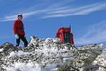
My understanding is that the green stile & firetrail next to the parking area is across private property, but NPWS/owners would prefer people use that route rather than the public thoroughfare that goes through the paddock.
I've marked in red the traditional route from the car park. This is the inbound route for the race, as well as the bushwalkers route to Ironpot.
- IronPot.jpg (200.38 KiB) Viewed 5194 times
The UTA website (https://uta.utmb.world/runners/training-medical) states
Recommended training options in place of Ironpot Ridge Descent: Run past Dunphys Campground and continue onto Megalong Rd. DO NOT turn left towards Foggy Knob and Ironpot Ridge. Whilst the climb up to Ironpot is open to public, the descent is on private land and cannot be accessed outside of race day.
- keithj
- Athrotaxis cupressoides
- Posts: 307
- Joined: Sun 01 Nov, 2015 7:27 pm
- Region: New South Wales
- Gender: Male
Re: Dunphys - Ironpot Mountain access issue
![]() by Allchin09 » Sat 26 Apr, 2025 10:02 pm
by Allchin09 » Sat 26 Apr, 2025 10:02 pm
Yes, I'm aware of the usual route.
Here's the facebook post which spurred this thread. I had also heard something similar from someone else. Again, I haven't see the sign or a photo of it but it seems to be a pretty clear 'go away' message.
Here's the facebook post which spurred this thread. I had also heard something similar from someone else. Again, I haven't see the sign or a photo of it but it seems to be a pretty clear 'go away' message.
I noticed there's new signs on Ironpot Ridge Firetrail saying KEEP OUT, PRIVATE PROPERTY, NO ENTRY FOR ANY WALKERS / RUNNERS / HORSE RIDERS etc, yet this is the only way to access Iron Pot Ridge Trail - which has a newish NPWS sign at the end of it??
Tackling the unknown and the awesome one adventure at a time!
Try www.bushwalkingmaps.com
Try www.bushwalkingmaps.com
- Allchin09
- Phyllocladus aspleniifolius
- Posts: 715
- Joined: Fri 27 Apr, 2012 3:24 pm
- ASSOCIATED ORGANISATIONS: Sydney Bush Walkers
- Region: New South Wales
- Gender: Male
Re: Dunphys - Ironpot Mountain access issue
![]() by johnf » Fri 02 May, 2025 3:11 pm
by johnf » Fri 02 May, 2025 3:11 pm
This photo was taken just on the boundary of the national park as you start up Ironpot Ridge. It was taken a few years ago.
Is the stile still there? Does anyone have a photo of the private property keep out sign?
I'd like to make a submission to National Parks on this issue.
Is the stile still there? Does anyone have a photo of the private property keep out sign?
I'd like to make a submission to National Parks on this issue.
- Ironpot Ridge Walking Access
- johnf
- Atherosperma moschatum

- Posts: 68
- Joined: Fri 10 Feb, 2012 9:19 am
- Region: New South Wales
- Gender: Male
Re: Dunphys - Ironpot Mountain access issue
![]() by Xplora » Sat 03 May, 2025 7:56 am
by Xplora » Sat 03 May, 2025 7:56 am
johnf wrote:This photo was taken just on the boundary of the national park as you start up Ironpot Ridge. It was taken a few years ago.
Is the stile still there? Does anyone have a photo of the private property keep out sign?
I'd like to make a submission to National Parks on this issue.
I am sure the local office will be aware of what is going on and it may be easier to go that way to find out what is going on instead of a submission. I remember when the style was put there soon after the Green Gully area was officially taken over by NPWS. Before that we would park down at the Carlon's gate and pay a nominal fee for the courtesy. There would have to be an access agreement for the private land or the road itself is part of an easement and it would be hard to imagine the government would not have made the access legal. I can't recall any contact with the owners of the property we walked past but their dogs gave us a welcome. This was my preferred access to Breakfast Creek/Cox's river junction and could do it in 90 minutes from the carpark down Ironmunger spur. The race organisers might have some insight also and the signs might only be temporary. It would be good to know the legal standing though. Good luck with it.
- Xplora
- Athrotaxis selaginoides
- Posts: 1670
- Joined: Sat 01 Aug, 2015 7:24 am
- Region: Victoria
- Gender: Male
Re: Dunphys - Ironpot Mountain access issue
![]() by Warin » Sat 03 May, 2025 10:49 am
by Warin » Sat 03 May, 2025 10:49 am
Best to call the rangers.
The legal easements may have followed trails/paths at some time, but with time things evolve in the real world. Possibly there are legal words to reflect these real world changes but it takes time (+ $?) for maps to reflect those changes. Looking on Sixmaps should give an indication of what were legal easements ... but I'd not rely on those indications.
The legal easements may have followed trails/paths at some time, but with time things evolve in the real world. Possibly there are legal words to reflect these real world changes but it takes time (+ $?) for maps to reflect those changes. Looking on Sixmaps should give an indication of what were legal easements ... but I'd not rely on those indications.
-
Warin - Athrotaxis selaginoides
- Posts: 1466
- Joined: Sat 11 Nov, 2017 8:02 am
- Region: New South Wales
Re: Dunphys - Ironpot Mountain access issue
![]() by keithj » Sat 03 May, 2025 11:11 am
by keithj » Sat 03 May, 2025 11:11 am
Warin wrote:Possibly there are legal words to reflect these real world changes but it takes time
Those legal words are Prescriptive Easement. In NSW law Prescriptive Easements develop over time (at least 20 years) through continuous and open use, provided that the landowner has not taken steps to prevent it and not explicitly granted permission.
As the landowner has now taken steps to prevent it, walkers should ensure that the continuous use continues and make a special effort to use that existing right of way.
And NPWS or bushwalking clubs (?) should consider going to court to ensure this Prescriptive Easement is legally recognised and registered.
- keithj
- Athrotaxis cupressoides
- Posts: 307
- Joined: Sun 01 Nov, 2015 7:27 pm
- Region: New South Wales
- Gender: Male
Re: Dunphys - Ironpot Mountain access issue
![]() by johnf » Sat 17 May, 2025 9:42 am
by johnf » Sat 17 May, 2025 9:42 am
I wrote to National Parks on behalf of Bushwalking NSW. I received a reply, which in summary was:
NPWS met with landowners last week and clarified their aim is to prevent runners from straying off the traditional Ironpot bushwalking track onto the UTA course and not to block the traditional bushwalking route. NPWS will adjust signage to better communicate that the traditional route is accessible, but the UTA route is restricted to race days.
Though there are some Crown Road reserves going through the property, probably better to stick to the traditional route as to not aggravate the landholders so they don't withdraw permission in the future.
- johnf
- Atherosperma moschatum
- Posts: 68
- Joined: Fri 10 Feb, 2012 9:19 am
- Region: New South Wales
- Gender: Male
Re: Dunphys - Ironpot Mountain access issue
![]() by Allchin09 » Sat 17 May, 2025 4:49 pm
by Allchin09 » Sat 17 May, 2025 4:49 pm
Thanks John
Tackling the unknown and the awesome one adventure at a time!
Try www.bushwalkingmaps.com
Try www.bushwalkingmaps.com
- Allchin09
- Phyllocladus aspleniifolius
- Posts: 715
- Joined: Fri 27 Apr, 2012 3:24 pm
- ASSOCIATED ORGANISATIONS: Sydney Bush Walkers
- Region: New South Wales
- Gender: Male
Re: Dunphys - Ironpot Mountain access issue
![]() by Xplora » Sun 18 May, 2025 7:14 am
by Xplora » Sun 18 May, 2025 7:14 am
Thanks John. A pretty quick response to your question from NPWS.
- Xplora
- Athrotaxis selaginoides
- Posts: 1670
- Joined: Sat 01 Aug, 2015 7:24 am
- Region: Victoria
- Gender: Male
Re: Dunphys - Ironpot Mountain access issue
![]() by sharks » Mon 30 Jun, 2025 11:23 am
by sharks » Mon 30 Jun, 2025 11:23 am
johnf wrote:I wrote to National Parks on behalf of Bushwalking NSW. I received a reply, which in summary was:
NPWS met with landowners last week and clarified their aim is to prevent runners from straying off the traditional Ironpot bushwalking track onto the UTA course and not to block the traditional bushwalking route. NPWS will adjust signage to better communicate that the traditional route is accessible, but the UTA route is restricted to race days.
Though there are some Crown Road reserves going through the property, probably better to stick to the traditional route as to not aggravate the landholders so they don't withdraw permission in the future.
I did this walk on the weekend and there is clear signage now that basically says this.
Something along the lines of "This is private property, backcountry walkers are allowed, but must stick to the path. The UTA was completed in May-2025 and there is no longer UTA training access."
- sharks
- Nothofagus cunninghamii

- Posts: 1
- Joined: Mon 30 Jun, 2025 11:15 am
- Region: New South Wales
- Gender: Male
14 posts
• Page 1 of 1
Return to New South Wales & ACT
Who is online
Users browsing this forum: No registered users and 36 guests