Has anyone had any experience with Garmin Custom Maps software? I am looking at buying a Garmin GPS unit however I do not wish to buy their maps. I have GeoTiff images of the maps I will need i just need to be able to use them on my GPS. I have been roaming around the garmin forum and have found little snippets of info but nothing concrete. So if you have experience with custom maps i have a few questions:
Can custom maps handle geotiff images, i.e automatically import them in there coordinate system?
Can it handle different coordinate systems and translate between them?
Does the quality of the import map get degraded when importing on to the GPS? Are Custom Maps are suitable alternative (relying on the type of map being imported of course) to the Garmin Maps or are they really only used in conjunction with?
Is the image type that is exported from Custom Maps on to the GPS, a KMZ/kml? if so do i really need to use Custom Maps software to use it on my GPS?
The Garmin forums mention that it can only handle 100 tiles but what distance does that equate to with 1:25000 maps and 6000X3000 resolution?
Alot of questions there but if anyone could help me I would appreciate it.
Garmin Custom Maps
24 posts
• Page 1 of 1
Garmin Custom Maps
![]() by frenchy_84 » Fri 08 Apr, 2011 2:18 pm
by frenchy_84 » Fri 08 Apr, 2011 2:18 pm
-

frenchy_84 - Athrotaxis selaginoides

- Posts: 1510
- Joined: Tue 04 Nov, 2008 7:00 pm
- Region: Queensland
- Gender: Male
Garmin Custom Maps
![]() by ULWalkingPhil » Fri 08 Apr, 2011 4:43 pm
by ULWalkingPhil » Fri 08 Apr, 2011 4:43 pm
frenchy_84 wrote:Has anyone had any experience with Garmin Custom Maps software? I am looking at buying a Garmin GPS unit however I do not wish to buy their maps. I have GeoTiff images of the maps I will need i just need to be able to use them on my GPS. I have been roaming around the garmin forum and have found little snippets of info but nothing concrete. So if you have experience with custom maps i have a few questions:
Can custom maps handle geotiff images, i.e automatically import them in there coordinate system?
Can it handle different coordinate systems and translate between them?
Does the quality of the import map get degraded when importing on to the GPS? Are Custom Maps are suitable alternative (relying on the type of map being imported of course) to the Garmin Maps or are they really only used in conjunction with?
Is the image type that is exported from Custom Maps on to the GPS, a KMZ/kml? if so do i really need to use Custom Maps software to use it on my GPS?
The Garmin forums mention that it can only handle 100 tiles but what distance does that equate to with 1:25000 maps and 6000X3000 resolution?
Alot of questions there but if anyone could help me I would appreciate it.
No, custom maps will not support geotiff., they need to be in there own format, which can be created using google earth. Yes quality is degraded, Each Custom Map can only support a small area, if you have a large area, you need to make many small custom maps, and there is that limit, so there not able to support a large area.
No way you will fit that 6000x3000 image on in one hit.
You want my opinion forget Custom Maps, unless you sign up to Garmin Custom Maps, there is a annual fee but it bypasses some of the restrictions and uses google earth images not topo maps, in my opinion the quality is crap.
If you must purchase the Garmin Oregon, use the free Open Street Maps, or purchase Garmin topo. But don't purchase the Garmin Oregon thar comes with the topo map, purchase the basic version with no maps and purchase the CD version of Garmin Topo, you can do a lot more with it, including installing onto your own computer, you can not do that with the Oregon with the maps included, get the basic version with no maps.
If you want to use topo maps and you own paper maps or many of the DVD you can purchase with topo maps, particularly in the RMAP or ECW map formats, purchase a Twonav Sportiva or the Twonav Aventura.

Here is a sample of the topo maps you can use on a Twonav
-

ULWalkingPhil - Lagarostrobos franklinii

- Posts: 2269
- Joined: Wed 05 Jan, 2011 2:14 pm
- Region: Queensland
Re: Garmin Custom Maps
![]() by Azza » Fri 08 Apr, 2011 6:39 pm
by Azza » Fri 08 Apr, 2011 6:39 pm
I converted all my GeoTiff of Tasmania and loaded then onto the Garmin GPSMap 62s.
Unfortunately Garmin limit the GPS to only supporting a very small number of files or maybe only 1 or its limited by size.. can't remember but it pretty much only accepted a few TasMaps before it decided to ignore them.
Basically if I know where I am going I can load a single Tasmap into the GPS.
Pretty annoying because I have the whole set already converted.
-

Azza - Phyllocladus aspleniifolius

- Posts: 979
- Joined: Thu 06 Mar, 2008 11:26 am
Re: Garmin Custom Maps
![]() by ILUVSWTAS » Fri 08 Apr, 2011 6:47 pm
by ILUVSWTAS » Fri 08 Apr, 2011 6:47 pm
MJD managed to make a joined version of all the tasmanian tasmaps, I have all of Tas on my Garmin60 CSX.
Im not sure how he did it Azza, might be worth asking if your having trouble??
Im not sure how he did it Azza, might be worth asking if your having trouble??
Nothing to see here.
-

ILUVSWTAS - Lagarostrobos franklinii
- Posts: 11027
- Joined: Sun 28 Dec, 2008 9:53 am
- Region: Tasmania
- Gender: Male
Garmin Custom Maps
![]() by ULWalkingPhil » Fri 08 Apr, 2011 7:38 pm
by ULWalkingPhil » Fri 08 Apr, 2011 7:38 pm
You can convert them using google earth, but it's not easy, I wrote a step by step article on how to do this for a new GPS magazine released in Australia soon, I don't know if it's gone to print yet. If I was home, I could pm you the instructions, but I'm out hiking and will not be home for over a week.
-
ULWalkingPhil - Lagarostrobos franklinii
- Posts: 2269
- Joined: Wed 05 Jan, 2011 2:14 pm
- Region: Queensland
Re: Garmin Custom Maps
![]() by ILUVSWTAS » Fri 08 Apr, 2011 7:44 pm
by ILUVSWTAS » Fri 08 Apr, 2011 7:44 pm
Phillipsart wrote:but I'm out hiking and will not be home for over a week.
Another tragic status updater from remote places??
Nothing to see here.
-
ILUVSWTAS - Lagarostrobos franklinii
- Posts: 11027
- Joined: Sun 28 Dec, 2008 9:53 am
- Region: Tasmania
- Gender: Male
Garmin Custom Maps
![]() by ULWalkingPhil » Fri 08 Apr, 2011 7:51 pm
by ULWalkingPhil » Fri 08 Apr, 2011 7:51 pm
Azza it's limited by size, to be honest it's a joke how small a file you need to use. Even if you could go larger file size, the Oregons are a bit slow opening them. It's a nightmare if you use the custom maps while driving, depending on the file size, to big and the maps don't refresh quick enough. However if you pay for the Garmin custom map, there don't appear to be the restrictions like there is if you make your own custom maps.
Lucky for me I received a much better handheld unit than the Oregons for writing the article.
In saying all this, I have not kept up with the latest, so there might be some magic software out there now, that I am not aware of that will all do this like magic.
Lucky for me I received a much better handheld unit than the Oregons for writing the article.
In saying all this, I have not kept up with the latest, so there might be some magic software out there now, that I am not aware of that will all do this like magic.
-
ULWalkingPhil - Lagarostrobos franklinii
- Posts: 2269
- Joined: Wed 05 Jan, 2011 2:14 pm
- Region: Queensland
Garmin Custom Maps
![]() by ULWalkingPhil » Fri 08 Apr, 2011 7:57 pm
by ULWalkingPhil » Fri 08 Apr, 2011 7:57 pm
Since receiving my new Gps I have not bothered with the Garmin Oregon, so I don't know what the latest is,
Do a search for Garmin Oregon Wiki, more info there can be found on the Garmin including custom maps
Do a search for Garmin Oregon Wiki, more info there can be found on the Garmin including custom maps
-
ULWalkingPhil - Lagarostrobos franklinii
- Posts: 2269
- Joined: Wed 05 Jan, 2011 2:14 pm
- Region: Queensland
Re: Garmin Custom Maps
![]() by frenchy_84 » Mon 11 Apr, 2011 12:55 pm
by frenchy_84 » Mon 11 Apr, 2011 12:55 pm
ILUVSWTAS wrote:MJD managed to make a joined version of all the tasmanian tasmaps, I have all of Tas on my Garmin60 CSX.
But what is the quality like? Can u run the whole joined Tasmap version without the need to use maps purchased from Garmin.
Perhaps I should change the question to, What GPS unit should i buy, that will allow me to do normal GPS functions such as routes, waypoints et al. Plus being able to upload my own maps rather than purchase additional maps. There was no particular reason why I was originally going with Garmin, there just the ones i saw at the shop and it seems most people have one.
Thanks Phillipsart for your advice. I will have a look at the Sportivas
-
frenchy_84 - Athrotaxis selaginoides
- Posts: 1510
- Joined: Tue 04 Nov, 2008 7:00 pm
- Region: Queensland
- Gender: Male
Re: Garmin Custom Maps
![]() by ollster » Mon 11 Apr, 2011 1:14 pm
by ollster » Mon 11 Apr, 2011 1:14 pm
Had a go at loading some similar files on the weekend, but got brickwalled by the software - not much flexibility there.
Quite *&%$#! for a $500 GPS (62s in my case) to not be able to deal with this stuff at least via some conversion method (storage isn't the issue seeing mine comes with 1.7Gb plus Micro SD which can be had in faily large sizes).
Obviously Garmin want us shelling out the extra $230 for theOzTopo Garmin Aus/NZ topo maps rather than DIY. Their software is very rudimentary too. Lucky for them the GPS works so well in the field, but it could be so much better.
Quite *&%$#! for a $500 GPS (62s in my case) to not be able to deal with this stuff at least via some conversion method (storage isn't the issue seeing mine comes with 1.7Gb plus Micro SD which can be had in faily large sizes).
Obviously Garmin want us shelling out the extra $230 for the
Last edited by ollster on Mon 11 Apr, 2011 3:43 pm, edited 1 time in total.
"I refuse to join any club that would have me as a member."
-

ollster - Lagarostrobos franklinii
- Posts: 3975
- Joined: Tue 02 Sep, 2008 4:14 pm
- ASSOCIATED ORGANISATIONS: LoveMyGoat.com
- Region: Australia
Re: Garmin Custom Maps
![]() by tastrax » Mon 11 Apr, 2011 1:35 pm
by tastrax » Mon 11 Apr, 2011 1:35 pm
I have tried the custom (RASTER) maps on garmin a couple of times and its failed miserably each time. The resolution if "car touring" is completely different than if "off track bushwalking" and I struggled to get an image that worked well at either scale and that fitted on the GPS. I could never get it to accept two maps in the same area at different resolutions without having to turn maps on and off. It was more hassle than it was worth.
Don't mix up these maps with the OzTopo/Topo Australia etc as they are VECTOR maps that work quite well.
No idea how MJD got all the (raster?) "tasmaps" on a Garmin 60CSX as I didn't think it was possible. A 62s...maybe, but I would love to see the results.
Don't mix up these maps with the OzTopo/Topo Australia etc as they are VECTOR maps that work quite well.
No idea how MJD got all the (raster?) "tasmaps" on a Garmin 60CSX as I didn't think it was possible. A 62s...maybe, but I would love to see the results.
-

tastrax - Lagarostrobos franklinii
- Posts: 2032
- Joined: Fri 28 Mar, 2008 6:25 pm
- Location: What3words - epic.constable.downplayed
- ASSOCIATED ORGANISATIONS: RETIRED! - Parks and Wildlife Service
- Region: Tasmania
Re: Garmin Custom Maps
![]() by frenchy_84 » Mon 11 Apr, 2011 1:37 pm
by frenchy_84 » Mon 11 Apr, 2011 1:37 pm
ollster wrote:Had a go at loading some similar files on the weekend, but got brickwalled by the software - not much flexibility there.
Quite *&%$#! for a $500 GPS (62s in my case) to not be able to deal with this stuff at least via some conversion method (storage isn't the issue seeing mine comes with 1.7Gb plus Micro SD which can be had in faily large sizes).
Obviously Garmin want us shelling out the extra $230 for the OzTopo maps rather than DIY. Their software is very rudimentary too. Lucky for them the GPS works so well in the field, but it could be so much better.
I have a couple of GIS wizards at my disposal to convert them it to different formats if it is worth it
-
frenchy_84 - Athrotaxis selaginoides
- Posts: 1510
- Joined: Tue 04 Nov, 2008 7:00 pm
- Region: Queensland
- Gender: Male
Re: Garmin Custom Maps
![]() by ollster » Mon 11 Apr, 2011 1:41 pm
by ollster » Mon 11 Apr, 2011 1:41 pm
frenchy_84 wrote:I have a couple of GIS wizards at my disposal to convert them it to different formats if it is worth it
Possibly. I didn't have much time to spend due to home renovations. I'd probably be better served using the Geotiffs and trying to convert those. I'll email.
"I refuse to join any club that would have me as a member."
-
ollster - Lagarostrobos franklinii
- Posts: 3975
- Joined: Tue 02 Sep, 2008 4:14 pm
- ASSOCIATED ORGANISATIONS: LoveMyGoat.com
- Region: Australia
Garmin Custom Maps
![]() by ULWalkingPhil » Mon 11 Apr, 2011 3:28 pm
by ULWalkingPhil » Mon 11 Apr, 2011 3:28 pm
frenchy_84 wrote:ILUVSWTAS wrote:MJD managed to make a joined version of all the tasmanian tasmaps, I have all of Tas on my Garmin60 CSX.
But what is the quality like? Can u run the whole joined Tasmap version without the need to use maps purchased from Garmin.
Perhaps I should change the question to, What GPS unit should i buy, that will allow me to do normal GPS functions such as routes, waypoints et al. Plus being able to upload my own maps rather than purchase additional maps. There was no particular reason why I was originally going with Garmin, there just the ones i saw at the shop and it seems most people have one.
Thanks Phillipsart for your advice. I will have a look at the Sportivas
If you where in Sydney, I would show you my Twonav Sportiva and Oregon, I've got both with me on my travels.
If you want to use Raster maps get the Sportiva, Raster maps are topo maps similar to your paper maps, most good map shops now sell them in digital format. You can also use your own paper maps and convert them after scanning into your computer with the included software that comes with the Twonav Sportiva. You can also use sat images from nearmap.com
If you go the direction of the Oregons be sure to purchase the Oregon without the included maps, the pick of the Oregons I think are the 550, than purchase the Garmin Topo on DVD and install the free Open Street Maps. I can help out with this if you go this route.
-
ULWalkingPhil - Lagarostrobos franklinii
- Posts: 2269
- Joined: Wed 05 Jan, 2011 2:14 pm
- Region: Queensland
Garmin Custom Maps
![]() by ULWalkingPhil » Mon 11 Apr, 2011 3:37 pm
by ULWalkingPhil » Mon 11 Apr, 2011 3:37 pm
ollster wrote:
Obviously Garmin want us shelling out the extra $230 for the OzTopo maps rather than DIY. Their software is very rudimentary too. Lucky for them the GPS works so well in the field, but it could be so much better.
Also, I've found the Garmin Topo maps are not very accurate, I own the first version that was released a year ago and it's not accurate up in my area including Fraser Island, I don't own the latest version, but from what I can see, I question the accuracy, particularly Fraser Island. I know the area well, it's where I live and the map is not accurate.
I think down around Sydney and in more popular ares the Garmin Topo maps are more accurate. This is why I suggest to also install the free OSM maps for the Garmin, I find it more accurate than any of the paid maps for the Garmin on the market and it's free.
-
ULWalkingPhil - Lagarostrobos franklinii
- Posts: 2269
- Joined: Wed 05 Jan, 2011 2:14 pm
- Region: Queensland
Garmin Custom Maps
![]() by ULWalkingPhil » Mon 11 Apr, 2011 3:41 pm
by ULWalkingPhil » Mon 11 Apr, 2011 3:41 pm
Oldster, I just noticed you mention OzTopo, OzTopo in my opinion are a very good map, although it has not been updated for some time now, it's much better map than Garmin Topo. OzTopo has nothing to do with Garmin. The only downside with OzTopo is, it's not a routable map.
-
ULWalkingPhil - Lagarostrobos franklinii
- Posts: 2269
- Joined: Wed 05 Jan, 2011 2:14 pm
- Region: Queensland
Re: Garmin Custom Maps
![]() by ollster » Mon 11 Apr, 2011 3:42 pm
by ollster » Mon 11 Apr, 2011 3:42 pm
Phillipsart wrote:Oldster, I just noticed you mention OzTopo, OzTopo in my opinion are a very good map, although it has not been updated for some time now, it's much better map than Garmin Topo. OzTopo has nothing to do with Garmin. The only downside with OzTopo is, it's not a routable map.
Arrgh, sorry. I meant Garmon Aus/NZ Topo maps... will fix
"I refuse to join any club that would have me as a member."
-
ollster - Lagarostrobos franklinii
- Posts: 3975
- Joined: Tue 02 Sep, 2008 4:14 pm
- ASSOCIATED ORGANISATIONS: LoveMyGoat.com
- Region: Australia
Re: Garmin Custom Maps
![]() by Azza » Mon 11 Apr, 2011 4:48 pm
by Azza » Mon 11 Apr, 2011 4:48 pm
ILUVSWTAS wrote:MJD managed to make a joined version of all the tasmanian tasmaps, I have all of Tas on my Garmin60 CSX.
Im not sure how he did it Azza, might be worth asking if your having trouble??
I don't think its feasible to create a usable single file of the 1:25k maps.. The fundamental difference is that Garmin Maps are vector based, Tasmaps are raster.
The size of the map set alone is more or less a GB. You reduce the scale too much and its useless. I doubt the poor ol' Garmin could cope with a 1GB raster, I think most PC's wouldn't. Garmin have done some half ar$ed attempt at supporting rasters so they can boast about the feature.
I've converted the whole set of Geotiff - I can load then on, but only one at a time. The garmin format is pretty sucky.
-
Azza - Phyllocladus aspleniifolius
- Posts: 979
- Joined: Thu 06 Mar, 2008 11:26 am
Re: Garmin Custom Maps
![]() by ILUVSWTAS » Mon 11 Apr, 2011 5:02 pm
by ILUVSWTAS » Mon 11 Apr, 2011 5:02 pm
Yeh look im no software guru so I dont know the details, but I do have all of Tasmania (maps) on my GPS
Nothing to see here.
-
ILUVSWTAS - Lagarostrobos franklinii
- Posts: 11027
- Joined: Sun 28 Dec, 2008 9:53 am
- Region: Tasmania
- Gender: Male
Re: Garmin Custom Maps
![]() by MJD » Tue 12 Apr, 2011 9:04 pm
by MJD » Tue 12 Apr, 2011 9:04 pm
Two different things. I joined all the 1:100k maps together for OziExplorer using one of their utilities. On the GPSMap 60CSx we have different versions of OzTopo.
Carpe diem
-

MJD - Athrotaxis selaginoides
- Posts: 1017
- Joined: Mon 26 May, 2008 11:24 pm
- Region: Tasmania
Re: Garmin Custom Maps
![]() by ILUVSWTAS » Wed 13 Apr, 2011 5:26 am
by ILUVSWTAS » Wed 13 Apr, 2011 5:26 am
MJD wrote:Two different things. I joined all the 1:100k maps together for OziExplorer using one of their utilities. On the GPSMap 60CSx we have different versions of OzTopo.
thanks MJ!!
Nothing to see here.
-
ILUVSWTAS - Lagarostrobos franklinii
- Posts: 11027
- Joined: Sun 28 Dec, 2008 9:53 am
- Region: Tasmania
- Gender: Male
Re: Garmin Custom Maps
![]() by DonQx » Tue 20 Aug, 2013 6:37 pm
by DonQx » Tue 20 Aug, 2013 6:37 pm
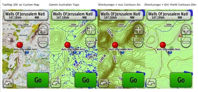
I've managed to make a few Custom Maps now for my new Oregon 450. For walking in Tassie: Lake Ada to Walls of J and Clark Cliffs Walk on Tas Peninsula.
Still learning the basics, but fairly pleased with what I've been able to do so far.
Here is a quick comparo of several map / contours combos around Dixon's Kingdom (in Tas, outside Walls of Jerusalem) ...
Still learning the basics, but fairly pleased with what I've been able to do so far.
Here is a quick comparo of several map / contours combos around Dixon's Kingdom (in Tas, outside Walls of Jerusalem) ...
Can't get enough of cruisy-paced overnite outdoor trips
Trip philosophy at www.ahack.org
Loc close to Hobart
Trip philosophy at www.ahack.org
Loc close to Hobart
-

DonQx - Athrotaxis cupressoides

- Posts: 348
- Joined: Sun 29 Apr, 2007 5:32 am
- Location: Land of Oz / Taz / Hobart
- Region: Tasmania
- Gender: Male
Re: Garmin Custom Maps
![]() by greyim » Wed 21 Aug, 2013 10:10 pm
by greyim » Wed 21 Aug, 2013 10:10 pm
nice comparison....
Nothing beats a nice camp fire
- greyim
- Athrotaxis cupressoides
- Posts: 231
- Joined: Fri 27 Mar, 2009 6:23 pm
- Region: Tasmania
Re: Garmin Custom Maps
![]() by DonQx » Thu 22 Aug, 2013 4:22 pm
by DonQx » Thu 22 Aug, 2013 4:22 pm
thx mate
Can't get enough of cruisy-paced overnite outdoor trips
Trip philosophy at www.ahack.org
Loc close to Hobart
Trip philosophy at www.ahack.org
Loc close to Hobart
-
DonQx - Athrotaxis cupressoides
- Posts: 348
- Joined: Sun 29 Apr, 2007 5:32 am
- Location: Land of Oz / Taz / Hobart
- Region: Tasmania
- Gender: Male
24 posts
• Page 1 of 1
Who is online
Users browsing this forum: No registered users and 8 guests