| Turn map |
Directions & comments |
|
|

From the Patonga Drive Start (a footpath).

There is a car park (about 5 m back from the start).

Find the Patonga Village at the start.
Find the The Boathouse at the start.

Find the artwork at the start.
 Turn left
.

After another 60 m pass the toilet (75 m on your left).

Then pass the "The Great North Walk" (9 m on your right).

Then pass the picnic table (30 m on your left).

After another 50 m pass the shelter (40 m on your left).
|
|
|

After another 125 m continue straight.
After another 45 m find the "Warrah Reserve boat ramp" (15 m on your left).
Continue straight.
|
|
|
After another 35 m continue straight.
|
|
|

After another 125 m turn around.

After another 15 m head up the steps (about 15 m long)
|
|
|

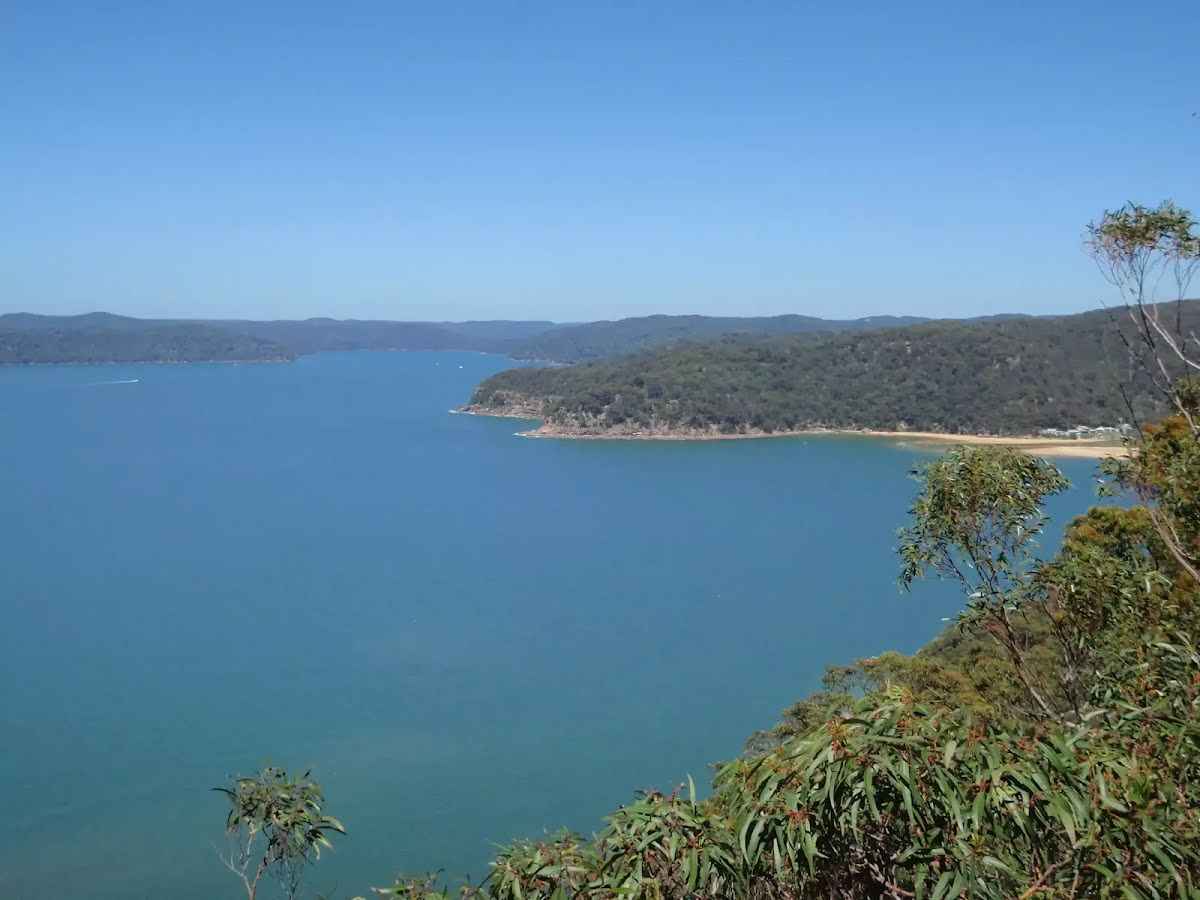
After another 450 m come to the viewpoint (25 m on your right).
 Veer left
.
|
|
|
After another 95 m continue straight.
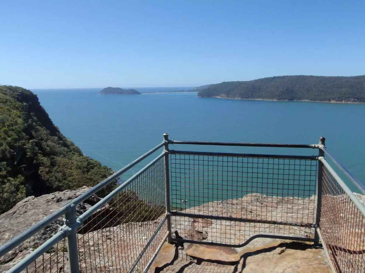
After another 30 m find the "Broken Bay View" (25 m on your right).
|
|
|
After another 310 m (from the Pearl Beach Patonga Firetrail) continue straight, to head along Pearl Beach Patonga Firetrail (a vehicle track).
After another 360 m pass the sign (on your right).
|
|
|
The starting point of an optional sidetrip. An optional side trip to Warrah Lookout. To start this optional side trip turn sharp right here. On returning from this side trip turn right when you get back to this intersection. Details below.
At the intersection of Tony Doyle Track & Pearl Beach Patonga Firetrail turn left (a footpath).

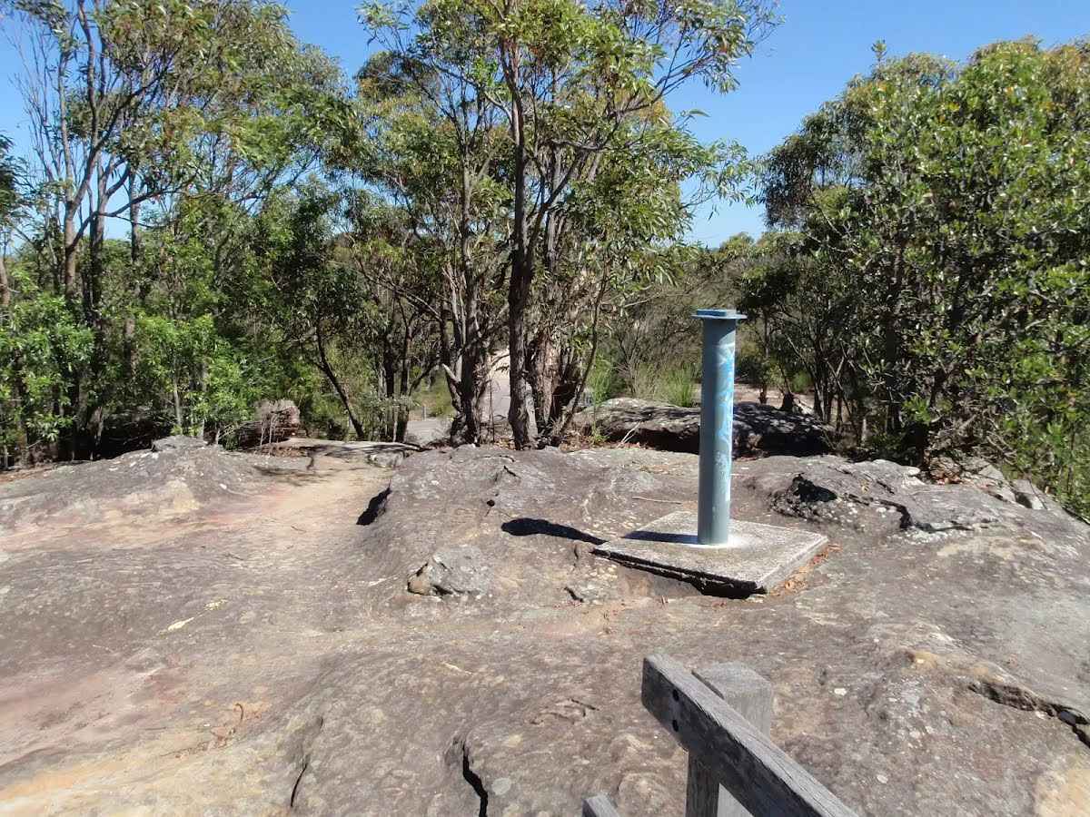
After another 295 m find the "Warrah Trig Station" (on your left).
After another 45 m pass the sign (on your right).
|
|
|
After another 135 m (from the Warrah Trig Road) continue straight, to head along Warrah Trig Road.
|
|
|
After another 150 m (at the intersection of Warrah Trig Road & Warrah Escape Trail) continue straight, to head along Warrah Trig Road.
|
|
|

After another 950 m (from the Warrah Trig Road) veer right (a walking track).
|
|
|
After another 235 m turn left.
After another 15 m (at the intersection of Warrah Patch Firetrail & Patonga Drive) continue straight, to head along Warrah Patch Firetrail (a vehicle track).
After another 7 m pass the "Waratah" (on your left).

After another 15 m head through/around the gate.
|
|
|

After another 105 m (from the Warrah Patch Firetrail) turn right, to head along Warrah Patch Firetrail.
|
|
|
After another 280 m (at the intersection of Warrah Patch Firetrail & PMG Firetrail) turn right, to head along Warrah Patch Firetrail.
|
|
|
After another 270 m (at the intersection of Van Dahls Firetrail & Warrah Patch Firetrail) turn left, to head along Van Dahls Firetrail.
|
|
|
After another 200 m (from the Van Dahls Firetrail) turn right, to head along Van Dahls Firetrail.
|
|
|
After another 1.1 km (at the intersection of Van Dahls Firetrail & Sani Depot Trail) continue straight, to head along Van Dahls Firetrail.
|
|
|
After another 730 m (from the Van Dahls Firetrail) continue straight, to head along Van Dahls Firetrail.
|
|
|
After another 900 m (from the Van Dahls Firetrail) continue straight, to head along Van Dahls Firetrail.
|
|
|
After another 185 m (at the intersection of Dillons Trail & Van Dahls Firetrail) turn left, to head along Dillons Trail (a walking track).
|
|
|
After another 75 m (at the intersection of Dillons Trail & Patonga Creek) continue straight, to head along Dillons Trail.
After another 1.9 km come to the viewpoint (on your right).
|
|
|
After another 280 m (at the intersection of Dillons Firetrail & Dillons Trail) turn right, to head along Dillons Firetrail (a vehicle track).
|
|
|
After another 1.3 km (at the intersection of Dillons Firetrail & Old Balast railway) continue straight, to head along Dillons Firetrail.
After another 360 m head through/around the gate.
|
|
|
After another 40 m (at the intersection of Nagari Road & Dillons Firetrail) veer left, to head along Nagari Road (a service road).
After another 1000 m head through/around the gate.
Mo-Fr 07:00-17:00
Sa-Su 08:00-16:00
|
|
|
After another 15 m (from the Nagari Road) continue straight, to head along Nagari Road.
|
|
|
After another 165 m (from the Nagari Road) continue straight, to head along Nagari Road.
|
|
|
After another 85 m (at the intersection of Nagari Road & Nagari Road Bush Reserve Track) continue straight, to head along Nagari Road.
|
|
|
After another 230 m (from the Railway Street) continue straight, to head along Railway Street.
After another 10 m (from the Railway Street) continue straight, to head along Railway Street (a highway|tertiary).
After another 30 m (from the Railway Street) continue straight, to head along Railway Street.
|
|
|
After another 100 m (from the Railway Street) continue straight, to head along Railway Street.

After another 50 m cross the bridge (about 25 m long)
|
|
|
After another 305 m (at the intersection of Railway Street & Hillview Street) continue straight, to head along Railway Street.
|
|
|
After another 80 m (from the Railway Street) continue straight, to head along Railway Street.
After another 50 m (from the Railway Street) continue straight, to head along Railway Street.
|
|
|
After another 30 m (from the Railway Street) continue straight, to head along Railway Street.
After another 30 m (from the Railway Street) continue straight, to head along Railway Street.
|
|
|
After another 60 m (from the Railway Street) continue straight, to head along Railway Street.
After another 30 m (from the Railway Street) continue straight, to head along Railway Street.
After another 15 m (from the Railway Street) continue straight, to head along Railway Street.
|
|
|
After another 80 m (from the Railway Street) continue straight, to head along Railway Street.
After another 15 m (at the intersection of Railway Street & MacArthur Parade) continue straight, to head along Railway Street.
After another 390 m pass the toilet (65 m on your left).
After another 20 m pass the picnic table (55 m on your left).

After another 8 m pass the playground (60 m on your left).
After another 35 m pass the "Stoney Park" (50 m on your left).
|
|
|
At the intersection of Railway Street & Rawson Road continue straight, to head along Railway Street (a road).
|
|
|
After another 120 m (from the Railway Street) continue straight, to head along Railway Street.
|
|
|
After another 260 m (at the intersection of Railway Street & Melba Street) continue straight, to head along Railway Street.
|
|
|
After another 225 m (at the intersection of Railway Street & Ocean Beach Road) continue straight, to head along Railway Street.
|
|
|
After another 145 m (at the intersection of Railway Street & Station Street) continue straight, to head along Railway Street.
After another 100 m pass the car park (6 m on your left).
|
|
|
After another 15 m (from the Railway Street) continue straight, to head along Railway Street.
After another 95 m pass the car park (4 m on your left).
|
|
|
After another 20 m (from the Railway Street) continue straight, to head along Railway Street.
After another 6 m pass the "Disabled Parking" (7 m on your left).
|
|
|
After another 40 m (from the Railway Street) continue straight, to head along Railway Street.
After another 10 m (from the Railway Street) turn left (a footpath).
After another 15 m continue straight.
|
|
|
After another 8 m turn right.
|
|
|
After another 25 m turn left.
Then head up the concrete steps (about 20 m long)
Then cross the bridge (about 8 m long)
A pay phone.
About 35 m past the end is a toilet. This toilet is wheelchair accessible.
|
|
|

The end.
|