| Turn map |
Directions & comments |
|
|

Start.

Find the car park at the start.

Then pass the toilet (15 m on your left). This toilet is male and female.

After another 50 m pass the "The Boathouse Palm Beach" (9 m on your left).

Then pass a seat (5 m on your right)., has a backrest.
Then pass the car park (15 m on your left).

After another 50 m pass the BBQ (about 40 m ahead).

Then pass the picnic table (about 45 m ahead).
|
|
|

Turn left.
After another 15 m pass the picnic table (20 m on your right).
After another 60 m pass the BBQ (40 m on your right).
After another 35 m pass a seat (15 m on your left).
|
|
|

Continue straight.
|
|
|
After another 25 m continue straight.
After another 10 m pass the toilet (25 m on your right). This toilet is wheelchair accessible.
After another 35 m pass the car park (20 m on your right).
|
|
|
After another 75 m turn left.
After another 7 m pass the car park (7 m on your left).
After another 150 m continue straight.
After another 160 m continue straight.
|
|
|
After another 55 m continue straight.
|
|
|

After another 80 m (at the intersection of Barrenjoey Lighthouse Track & Smugglers Track) veer left, to head along Barrenjoey Lighthouse Track.

Then pass the sign (on your right).

After another 600 m come to the viewpoint (on your right).

After another 140 m head through/around the gate.
After another 15 m pass a seat (on your left)., has no backrest.
|
|
|
After another 7 m (at the intersection of Barrenjoey Lighthouse Track & Smugglers Track) continue straight (a walking track).

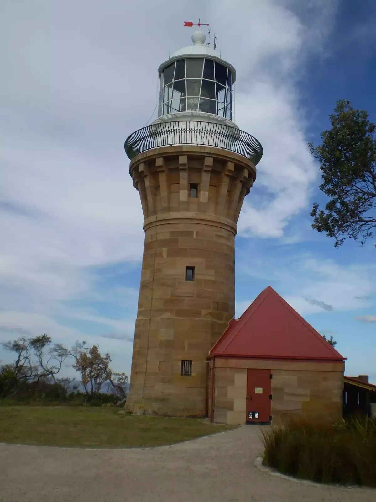
After another 20 m pass the "Barrenjoey Lighthouse" (10 m on your right).
Then pass a seat (7 m on your left)., has a backrest.
Continue straight.

After another 10 m find the "Grave Of George Mulhall" (on your on).
After another 20 m find the "Site of the First Barrenjoey Lighthouses" (on your right).
After another 205 m come to the viewpoint (55 m on your right).
Then come to the viewpoint (70 m on your right).
|
|
|
After another 240 m (at the intersection of Smugglers Track & Barrenjoey Lighthouse Track) continue straight, to head along Smugglers Track.
After another 25 m come to the "Gledhill Lookout" (5 m on your right).
Then pass a seat (7 m on your right)., has a backrest.
Then pass the "Barrenjoey Lighthouse" (about 10 m ahead).
After another 15 m find the "Grave Of George Mulhall" (on your on).
After another 30 m find the "Site of the First Barrenjoey Lighthouses".
After another 380 m come to the viewpoint (55 m on your left).
Then come to the viewpoint (70 m on your left).
Then find the "Barrenjoey Lighthouse" (20 m on your left).

Then pass the water tap (15 m on your left).

Then head down the steps (about 20 m long)
|
|
|
From the Smugglers Track continue straight, to head along Smugglers Track.
After another 10 m head down the steps (about 155 m long)
Then pass the toilet (9 m on your left).
After another 230 m head down the steps (about 30 m long)
After another 45 m head down the steps (about 65 m long)
|
|
|
At the intersection of Smugglers Track & Barrenjoey Lighthouse Track turn left (a vehicle track).
|
|
|
After another 135 m turn left.
After another 250 m pass the sign (on your left).
Site of the First Barrenjoey Lighthouses.
After another 315 m come to the viewpoint (on your right).
After another 40 m pass the toilet (about 9 m ahead).
After another 45 m pass the water tap (15 m on your right).
Then find the "Barrenjoey Lighthouse" (20 m on your right).
After another 25 m head through/around the gate.
After another 10 m pass a seat (on your left)., has no backrest.
After another 20 m come to the "Gledhill Lookout" (5 m on your left).
Then pass the "Barrenjoey Lighthouse" (10 m on your right).
Then find the "Grave Of George Mulhall" (on your on).
After another 195 m come to the viewpoint (55 m on your right).
Then come to the viewpoint (70 m on your right).
Continue straight.
|
|
|

After another 125 m turn right.
After another 160 m continue straight.
After another 150 m continue straight.
After another 105 m continue straight.
After another 100 m pass the car park (45 m on your right).
After another 120 m pass the car park (55 m on your right).
After another 20 m pass the car park (45 m on your right).
After another 55 m pass the car park (50 m on your right).
After another 190 m pass the toilet (55 m on your right).
After another 140 m turn right.
After another 110 m pass the "Dunes" (45 m on your right).
|
|
|
Turn left.

After another 30 m pass the "Governor Phillip Park Playground" (30 m on your right).
|
|
|
After another 25 m (from the Beach Road) turn left, to head along Beach Road (a road).
After another 45 m pass the car park (45 m on your left).
After another 270 m pass the "Ocean Road Reserve" (5 m on your left).
|
|
|
From the Ocean Road turn left (a walking track).
|
|
|
After another 85 m (from the Ocean Road) veer left, to head along Ocean Road (a road).
After another 40 m (from the Ocean Road) continue straight, to head along Ocean Road.
After another 40 m pass a seat (15 m on your left).
After another 20 m (from the Ocean Road) continue straight, to head along Ocean Road.
After another 8 m pass the car park (8 m on your left).
After another 35 m pass a seat (30 m on your left).
|
|
|
After another 5 m (at the intersection of Ocean Road & Palm Beach Road) continue straight, to head along Ocean Road (a residential road).
After another 45 m pass the picnic table (25 m on your left).
After another 4 m (from the Ocean Road) continue straight, to head along Ocean Road.
After another 15 m pass a seat (15 m on your left).
After another 7 m (from the Ocean Road) continue straight, to head along Ocean Road.
Then pass the toilet (15 m on your left). This toilet is wheelchair accessible.
After another 45 m pass the toilet (15 m on your left). This toilet is wheelchair accessible.
After another 90 m pass the water tap (15 m on your left).
Then pass the cafe (10 m on your right).
Then pass the "2108 Expresso" (9 m on your right).
After another 145 m pass the "Wiltshire Park" (10 m on your right).
After another 65 m pass the "Hordern Park" (15 m on your right).
|
|
|
After another 60 m (from the Ocean Road) turn right (a footpath).
|
|
|

After another 290 m (from the Florida Road) turn around, to head along Florida Road (a road).
|
|
|
After another 120 m (from the Florida Road) turn left (a steps).

Then head up the steps (about 140 m long)
|
|
|
From the Pacific Road turn left, to head along Pacific Road (a highway|tertiary).
|
|
|
After another 8 m (at the intersection of Ebor Road & Mitchell Road) turn right, to head along Ebor Road (a residential road).
After another 125 m (at the intersection of Ebor Road & Ralston Road) turn right, to head along Ebor Road.
After another 195 m (at the intersection of Ebor Road & McKay Road) continue straight, to head along Ebor Road.
|
|
|
After another 185 m (at the intersection of Cynthea Road & Boanbong Road) continue straight, to head along Cynthea Road.
|
|
|

After another 320 m (at the intersection of Bynya Road & Cynthea Road) veer right, to head along Bynya Road (a highway|tertiary).
|
|
|

After another 210 m (at the intersection of Norma Road & Bynya Road) turn sharp left, to head along Norma Road.
After another 225 m (at the intersection of Norma Road & Pacific Road) continue straight, to head along Norma Road.
After another 260 m pass the "Norma Park" (on your right).
|
|
|
After another 115 m (at the intersection of Whale Beach Road & Norma Road) turn right, to head along Whale Beach Road (a road).
|
|
|
After another 350 m (from the Whale Beach Road) turn left (a steps).
Then head up the steps (about 110 m long)
After another 410 m pass the car park (15 m on your right).
After another 115 m pass the car park (35 m on your right).
Then pass the BBQ (25 m on your right).
After another 95 m pass the car park (20 m on your right).
|
|
|
After another 40 m continue straight.
After another 55 m pass the "Whale Beach Reserve" (15 m on your right).
|
|
|
From the Malo Road turn right, to head along Malo Road (a residential road).
|
|
|
After another 120 m (at the intersection of Whale Beach Road & Malo Road) turn left, to head along Whale Beach Road (a road).
|
|
|
After another 275 m (at the intersection of Whale Beach Road & Beauty Drive) continue straight, to head along Whale Beach Road.
|
|
|
After another 550 m (at the intersection of Whale Beach Road & Rayner Road) continue straight, to head along Whale Beach Road.
|
|
|
After another 170 m (at the intersection of Whale Beach Road & Careel Head Road) continue straight, to head along Whale Beach Road.
|
|
|
After another 265 m (at the intersection of Bangalley Head Walking Track & Whale Beach Road) turn left, to head along Bangalley Head Walking Track (a walking track).
After another 50 m pass the sign (on your left).
Then pass the sign (on your right).
After another 85 m pass the sign (on your left).
After another 220 m come to the viewpoint (20 m on your left).
|
|
|
From the Bangalley Head Walking Track turn right, to head along Bangalley Head Walking Track.
After another 40 m pass the sign (on your right).
After another 15 m pass the sign (on your on).
After another 30 m come to the viewpoint (60 m on your left).
After another 15 m pass the sign (70 m on your left).
After another 70 m pass the sign (on your left).
After another 35 m come to the viewpoint (25 m on your left).
|
|
|
From the Bangalley Head Walking Track veer right, to head along Bangalley Head Walking Track.
After another 25 m pass the sign (on your on).
After another 35 m pass the sign (on your on).
After another 20 m come to the viewpoint (on your left).
After another 215 m pass the sign (on your on).
After another 35 m pass a seat (on your right).
After another 170 m pass the sign (on your left).
After another 5 m pass the "Birds of Bangalley Headland" (on your left).
Then pass the sign (on your left).
|
|
|
After another 25 m (from the Bangalley Head Walking Track) veer left.
|
|
|
After another 30 m (from the Marine Parade) veer left, to head along Marine Parade (a residential road).
|
|
|
After another 80 m (at the intersection of Marine Parade & Urara Road) continue straight, to head along Marine Parade.

After another 160 m pass the "St Michaels Cave" (80 m on your left).
|
|
|
At the intersection of Marine Parade & Coonanga Road continue straight, to head along Marine Parade.
After another 280 m (from the Marine Parade) continue straight, to head along Marine Parade.
After another 110 m (at the intersection of Marine Parade & Harley Road) continue straight, to head along Marine Parade.
After another 140 m pass the car park (6 m on your left).
|
|
|
After another 3 m (at the intersection of Yellow Brick Road & Marine Parade) continue straight, to head along Yellow Brick Road (a highway|cycleway).
After another 20 m pass the car park (5 m on your right).
After another 35 m pass the car park (on your right).
|
|
|
After another 40 m (from the Yellow Brick Road) continue straight, to head along Yellow Brick Road.
Then pass the car park (4 m on your right).
After another 135 m pass the "Avalon Beach Reserve" (on your right).
After another 15 m pass the "Des Creagh Reserve" (on your left).
|
|
|
After another 30 m (from the Yellow Brick Road) continue straight, to head along Yellow Brick Road.
|
|
|
After another 50 m (from the Yellow Brick Road) continue straight, to head along Yellow Brick Road.
|
|
|
After another 40 m (from the Yellow Brick Road) continue straight, to head along Yellow Brick Road.
|
|
|
After another 115 m (from the Yellow Brick Road) turn left (a footpath).
|
|
|
After another 6 m turn right.
|
|
|
After another 95 m turn left.
After another 30 m pass the car park (on your right).
After another 15 m pass the park (50 m on your right).
Then pass the toilet (45 m on your right).
|
|
|
Continue straight.
|
|
|
After another 10 m continue straight.
About 55 m past the end is a restaurant.
|
|
|

The end.
|