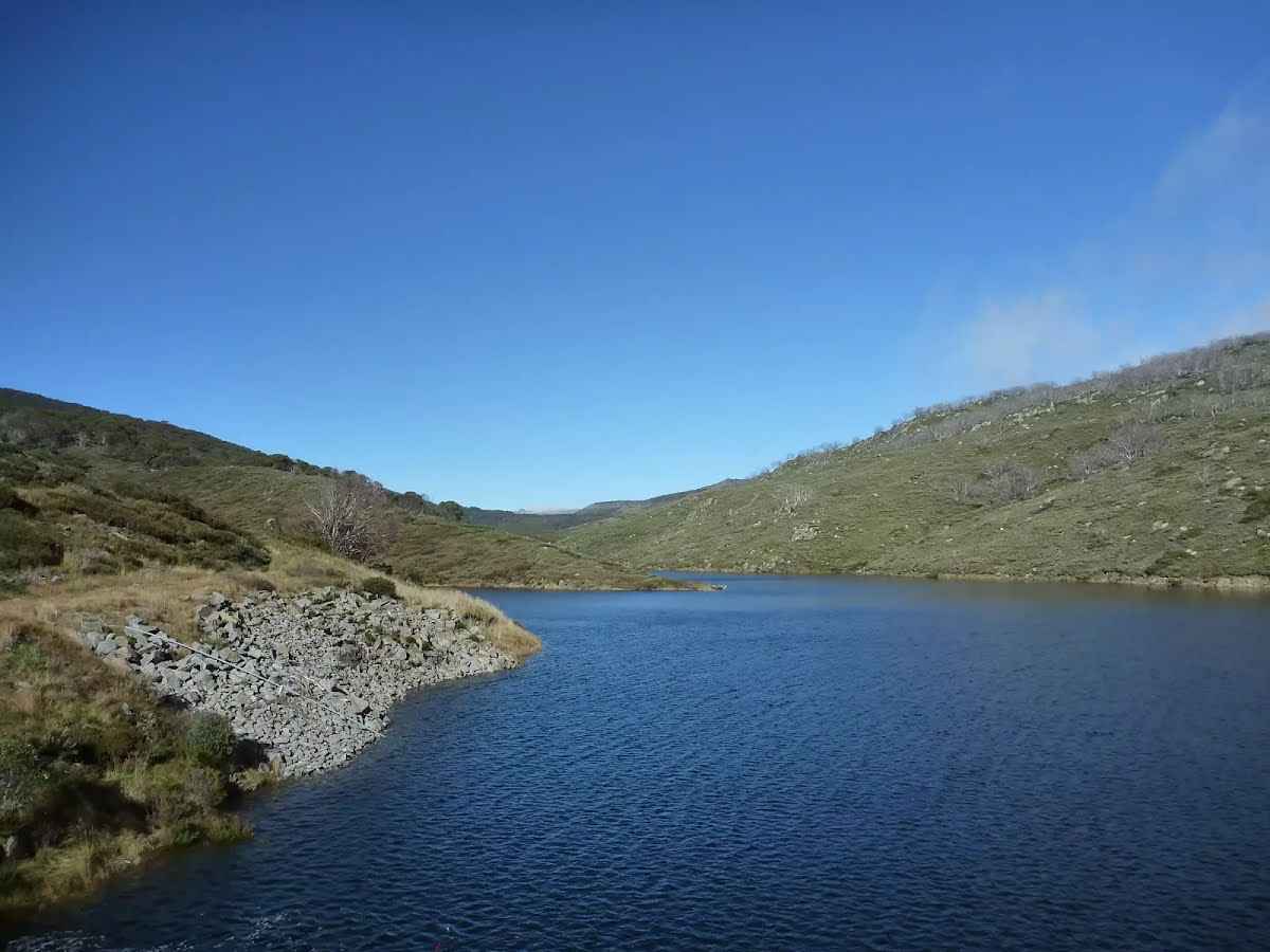
| Start | From the Mount Tate Road (-36.3775161,148.3764103) |
| Mode | Car (A park entry fee is required for driving into the park.) |
| Directions | From Barry Way
|

|
|
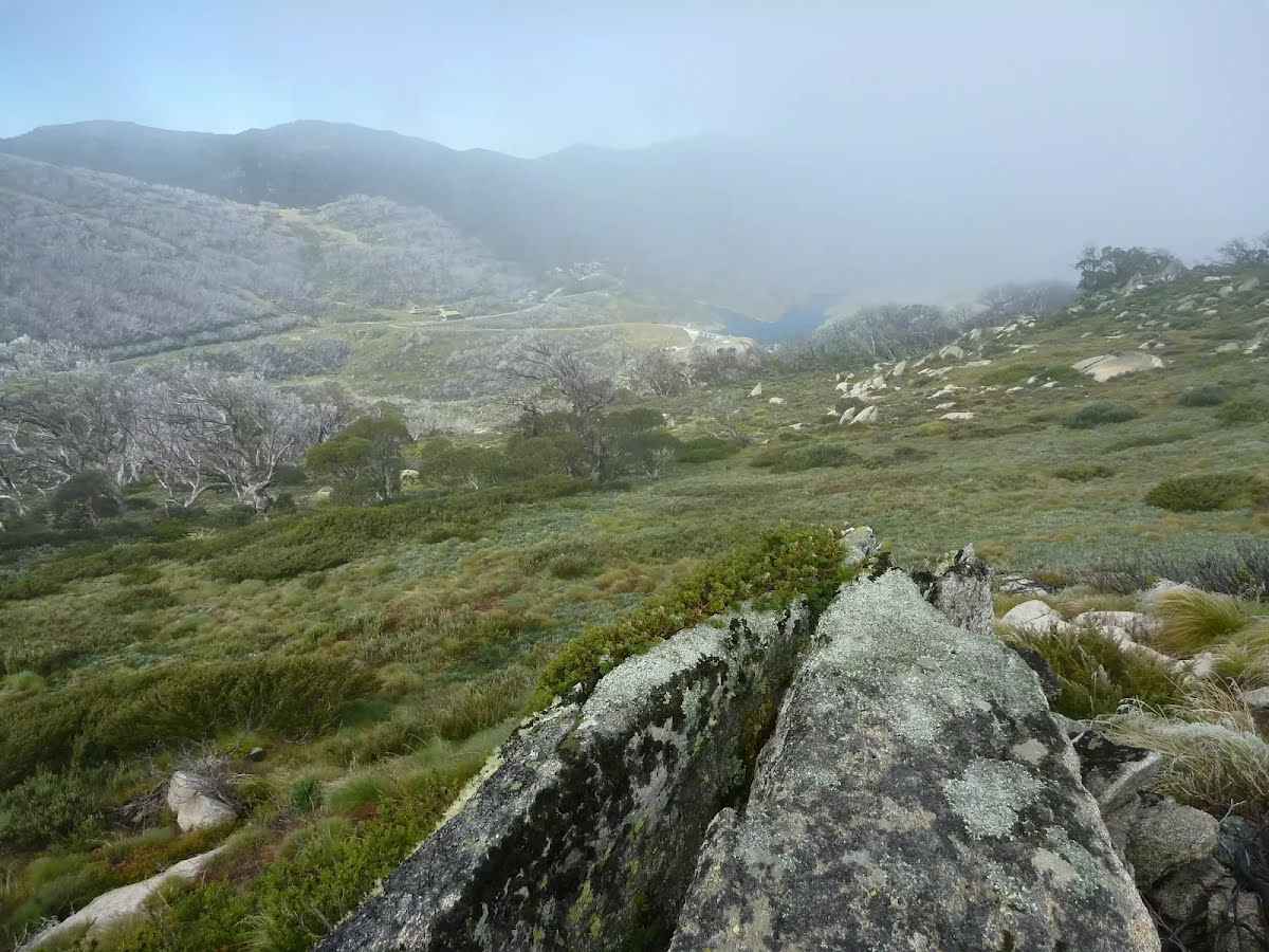
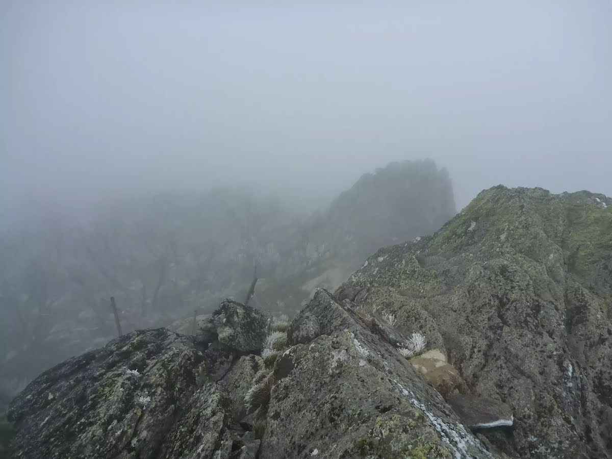
Class 6/6 Very Hard off track |
|---|---|
| Length | 5.9 km |
| Time | 2 h 45 min to 3 h |
| Quality of track | Rough unclear track (5/6) |
| Gradient | Very steep and difficult rock scrambles (5/6) |
| Signage | No directional signs (5/6) |
| Infrastructure | No facilities provided (5/6) |
| Experience Required | Very high level of bushwalking experience recommended (6/6) |
| Weather | Forecasted & unexpected severe weather likely to have an impact on your navigation and safety (5/6) |
| Item | From Start | Name & link to notes |
|---|---|---|
Toilet
| 185 m | [toilet] |
The speed limit on Guthega Road has been reduced to 60km for the entirety of the road.
Please abide by all traffic control signage and observe all directions from NPWS staff and contractors.
To assist in planning your journey safely, please allow extra time in your travel plans and drive to conditions.
For more information, call the Snowy Region Visitor Centre, Jindabyne on 02 6450 5600.
There is an increase in heavy machinery and light vehicle movements on the Snowy Mountains Highway (between Cooma to Tumut) and Link and Tantangara Roads within Kosciuszko National Park due to the Snowy 2.0 project. Visitors are likely to encounter heavy machinery and trucks whilst accessing Wares Yards campground, this will continue for a number of years and involves the use of specialised heavy vehicle combinations for transporting materials associated with the project. For further information please go to Snowy 2.0 Traffic Schedule — Future Generation Joint Venture
Rawson Pass toilet is closed until the end of winter 2025. Seamans Hut toilet will remain open all winter.
You are encouraged to carry out your human waste when toilets are not available on the Main Range. Please refer to these resources for more information:
For more information, contact the local NPWS office.
Clarke Gorge walking track is closed due to increased risk of rockfall during winter. This closure will be reviewed Thursday 2 October and may be extended.
Penalties apply for non-compliance. For more information, call the NPWS Tumut office on 02 6947 7000.
The Byadbo WIlderness Area and surrounding locations in this park are closed from 7am, Monday 28 July to 6pm, Friday 8 August 2025 for aerial shooting for feral animal control. Control operations will not be undertaken on weekends.
Closure notices will be placed at relevant access points. Do not enter the closed areas. Penalties apply for non-compliance.
The closed areas are:
For more information, please contact the NPWS Jindabyne office via email at srvc@environment.nsw.gov.au or (02) 6450 5555.
Several buildings in the Bullocks Hut complex are closed until further notice for restoration works. Please do not enter the construction sites.
Penalties apply for non-compliance. For more information, call the Snowy Region Visitor Centre on 02 6450 5600 or visit the NSW National Parks safety page for park safety guidelines.
Areas above 1600m in altitude in Kosciuszko National Park are typically snow covered in winter:
General:
Be prepared:
Travel with care:
Avalanche:
Perisher/Main Range - areas above about 1600m, including: Kosciuszko walk Thredbo to Mount Kosciuszko, Main Range walking track, Mount Kosciuszko Summit walk, Guthega to Charlotte Pass walking track, Charlotte Pass Village to Perisher walk, Perisher to Bullocks Flat walk, Mt Stillwell walk, Snowgums boardwalk, Porcupine track, Hanells Spur walk, Illawong walk, Schlink Hut walk and Dead Horse Gap walking track:
Expect continuous snow cover:
Sub-alpine - areas above 1500m - Rainbow Lake walk, Rennix walk, Thredbo River track:
Expect long stretches of snow cover with occasional continuous coverage:
For more information, call the NPWS Snowy Region Visitor Centre on 02 6450 5600.
A baiting program using meat baits and canid pest ejectors containing 1080 (sodium fluoroacetate) poison will be conducted from Saturday 22 March 2025 to Monday 22 September 2025 in Kosciuszko National Park.
The program will be conducted in the northern precinct of the park, which includes the following areas:
Entry into baiting locations will be identifiable by signs.
Domestic pets are not permitted in NSW national parks and reserves. Pets and working dogs may be affected (1080 is lethal to cats and dogs). Pets and working dogs must be restrained or muzzled in the vicinity and must not enter the baiting location. In the event of accidental poisoning seek immediate veterinary assistance.
For further information, please call the NPWS Tumut area office on 02 6947 7000.
The following roads in Kosciuszko National Park will be closed for winter from 6 June to 6 October 2025:
Other current road conditions can be found on the RMS Live Traffic website. Penalties apply for non-compliance. For more information, please contact the NPWS Snowy Region Visitors Centre on 02 6450 5600 or visit the NSW National Parks safety page for park safety guidelines.
There is an increase in heavy and light vehicle movements on the Snowy Mountains Highway (between Cooma to Tumut) and Link and Tantangara Roads within Kosciuszko National Park. This traffic will continue for a number of years and involves the use of specialised heavy vehicle combinations for transporting materials associated with the Snowy 2.0 project and other projects in the region.
There will also be ongoing maintenance and upgrades to roads in the area as part of the project, particularly along Link and Tantangara Roads.
To assist in planning your journey safely, please check for alerts on the NSW National Parks and Wildlife Service website or Snowy 2.0 Traffic Schedule — Future Generation Joint Venture.
For more information, call the NPWS Tumut area office on 02 6947 7000 or the Snowy 2.0 FGJV team community hotline on 1800 766 992.
The suspension footbridge crossing the Murray River (Victorian border) at Tom Groggin Station is unsafe for pedestrian access and is closed until further notice.
Penalties apply for non-compliance.
For further information, please contact the Jindabyne NPWS office on (02) 6450 5555.
Transport for NSW will be carrying out repairs to Yarrangobilly Caves Road, Yarrangobilly Caves from Tuesday 22 July 2025. Shot delays are expected and additional time should be planned for when travelling to accommodation and cave tours. Access conditions will change, drive safely and follow directions of roadwork signs and traffic control.
For more information visit https://www.livetraffic.com/incident-details/242308, or download the Live Traffic NSW app.
Please be aware that the Ngarigo campground access road is currently snow-covered and may pose a hazard to vehicles exiting and entering the campground, particularly in the mornings when snow cover is frozen.
Please exercise caution when using the road. Park users are reminded that penalties apply for failing to carry tyre chains in Kosciuszko National Park during winter (4WDs exempt).
For more information, please contact the NPWS Jindabyne office on (02) 6450 5555.
A number of sites in Kosciuszko National Park are closed or may have other restrictions until further notice.
Road Closures
Olsens Road BEYOND Geehi Dam. Olsens Road remains open from the Alpine Way to Geehi Dam.
Fire-affected areas
Some sections of Kosciuszko National Park which burnt during the 2019/2020 fires remain closed. These areas include:
Huts that burnt down in the 2020 fires
These locations remain open, but the following huts or buildings have been lost:
Snowy 2.0 works affecting access to Tantangara Road and Tantangara Dam
Do not enter closed areas in Kosciuszko National Park. Penalties apply for non-compliance. For more information, contact the local NPWS office.
The NSW National Parks and Wildlife Service (NPWS) and contractors will be undertaking upgrade works at Tom Groggin camping area throughout 2025. These works will include additions to campground facilities, including fire pits and picnic tables, rehabilitation planting, restoration of damaged campground surfaces, and construction of a new shelter at the day use area.
As a result, some areas of the lower campground will be closed to camping throughout winter 2025 to allow surfaces to rehabilitate. The majority of Tom Groggin will remain open to camping.
Visitors may experience some delays during construction works. Please comply with all instructions from NPWS staff and contractors. Penalties apply for non-compliance.
For more information please contact the NPWS Jindabyne office on 02 6450 5555.
Some parts of Tantangara Reservoir will be closed intermittently until further notice for Snowy 2.0 construction activities involving controlled blasts. Full exclusion zones will be established prior to and during blast operations. The closed areas are:
Penalties apply for non-compliance. For more information, contact the local NPWS office.
Access to Buddong Falls campground and Buddong Falls track from Laurel Hill is closed due to Forestry Corporation operations on Browns Road. Access is still possible from the Elliott Way, following Bago Powerline Road until it becomes Bago Boundary Road.
For more information, contact the Tumut NPWS office (02) 6947 7000.
NSW National Parks and Wildlife Service (NPWS) is conducting an ongoing winter ground baiting program from Monday 30 June 2025 to Sunday 28 September 2025. The operation will use 1080 (sodium fluoroacetate) poison for the control of feral foxes.
The program will take place in areas of Kosciuszko National Park including:
The program is designed to minimise predator impacts on wildlife, especially threatened species.
Signs will be placed at the entry to the baiting location. Domestic pets are not permitted in NSW National Parks managed lands. Pets and working dogs may be affected (1080 is lethal to cats and dogs). Pets and working dogs must be restrained or muzzled in the vicinity and must not enter the baiting location. In the event of accidental poisoning seek immediate veterinary assistance.
Please contact the local NPWS area office for more information on (02) 6450 5555.
The Thredbo Valley Track is now closed to cyclists for winter between Thredbo Resort and Gaden Trout Hatchery. The track between Gaden and Thredbo River Picnic Area is open for cycling.
Walking is permitted between:
Ngarigo campground to Bullocks Flat remains closed to all users due to track conditions and maintenance works in progress.
Penalties apply for non-compliance. Please contact the Snowy Region Visitor Centre for further information.
Yarrangobilly Village campground will be partially closed for rehabilitation works from Monday 14 April to Friday 19 December 2025. Camping at Yarrangobilly Village campground will still be available during this time in a restricted area.
For further information please call NPWS Tumut office on (02) 6947 7000.
The following areas are closed from Monday 25 February 2019 until early 2027 due to the Snowy 2.0 works:
This closure applies unless otherwise extended or removed.
Penalties apply for non-compliance. For more information, please call the NPWS Tumut area office on 02 6947 7000 or visit the NSW National Parks safety page for park safety guidelines.
NSW National Parks and Wildlife Service (NPWS) is conducting an ongoing ground baiting program from 24th February 2025 to 24th August 2025 . The operation will use 1080 (sodium fluoroacetate) poison for the control of feral animals including wild dogs and foxes.
The program will take place in Kosciuszko National Park and Clarkes Hill, Bogandyera and Jingellic Nature Reserves.
The program is designed to minimise predator impacts on wildlife, especially threatened species, and to minimise impact of wild dogs on neighbouring stock.
Signs will be placed at the entry to the baiting location. Domestic pets are not permitted in NSW National Parks managed lands. Pets and working dogs may be affected (1080 is lethal to cats and dogs). Pets and working dogs must be restrained or muzzled in the vicinity and must not enter the baiting location. In the event of accidental poisoning seek immediate veterinary assistance.
Please contact the local Khancoban NPWS area office for more information on 02 6070 8400.
NSW National Parks and Wildlife Service (NPWS) will be conducting a baiting program in the north east precinct of Kosciuszko National Park, Scabby Range and Yaouk Nature Reserves within the Adaminaby/Yaouk wild dog control area.
The program will be continuous and ongoing between 1 March 2025 and 31 August 2025, and will use meat baits and canid pest ejectors containing 1080 (sodium fluroacetate) poison for the control of wild dogs and foxes.
All baiting locations will be identifiable by signs.
Domestic pets are not permitted in NSW national parks and reserve. Pets and working dogs may be affected, and 1080 is lethal to cats and dogs. Pets and working dogs in the vicinity must be restrained or muzzled and must not enter the baiting location. In the event of accidental poisoning seek immediate veterinary assistance.
For further information please call the NPWS Tumut area office on 02 6947 7000.
The NSW National Parks and Wildlife Service (NPWS) will be conducting an ongoing baiting program from Saturday 8 February 2025 to Thursday 7 August 2025. The operation will use 1080 (sodium fluoroacetate) poison for the control of wild dogs and foxes. This program is designed to minimise predator impacts on wildlife, especially threatened species, and to minimise the impact of wild dogs on neighbouring stock.
Baiting programs will take place across Kosciuszko National Park in Thredbo/Ingebyra, Dalgety/Paupong and Corrowong/Tombong/Merriangaah Wild Dog Plan Areas. Baiting programs will also be undertaken in Paupong, Merriangaah and Quidong Nature Reserves.
This includes the following sections of Kosciuszko National Park: Thredbo Valley, Moonbah, Ingebyra, Paupong, Numbla Vale and Corrowong.
Signs will be placed at the entry to the baiting location. Domestic pets are not permitted in NSW National Parks managed lands. Pets and working dogs may be affected (1080 is lethal to cats and dogs). Pets and working dogs must be restrained or muzzled in the vicinity and must not enter the baiting location. In the event of accidental poisoning seek immediate veterinary assistance.
For further information, please call the Jindabyne area office on 02 6450 5555.