
Two summers in one year are better than one. For the past 25 years or so, during the North American winter, we have taken annual punishment holidays in the antipodes – Australia or New Zealand. Such holidays involved loading up our mountain bikes with camping gear and exploring back roads. They are called punishment holidays because we made ourselves ride at least six hours a day before allowing ourselves to enjoy some of the wonderful wines produced by those countries.

Two old fahrt Canadians in Kosciuszko NPPam Olson

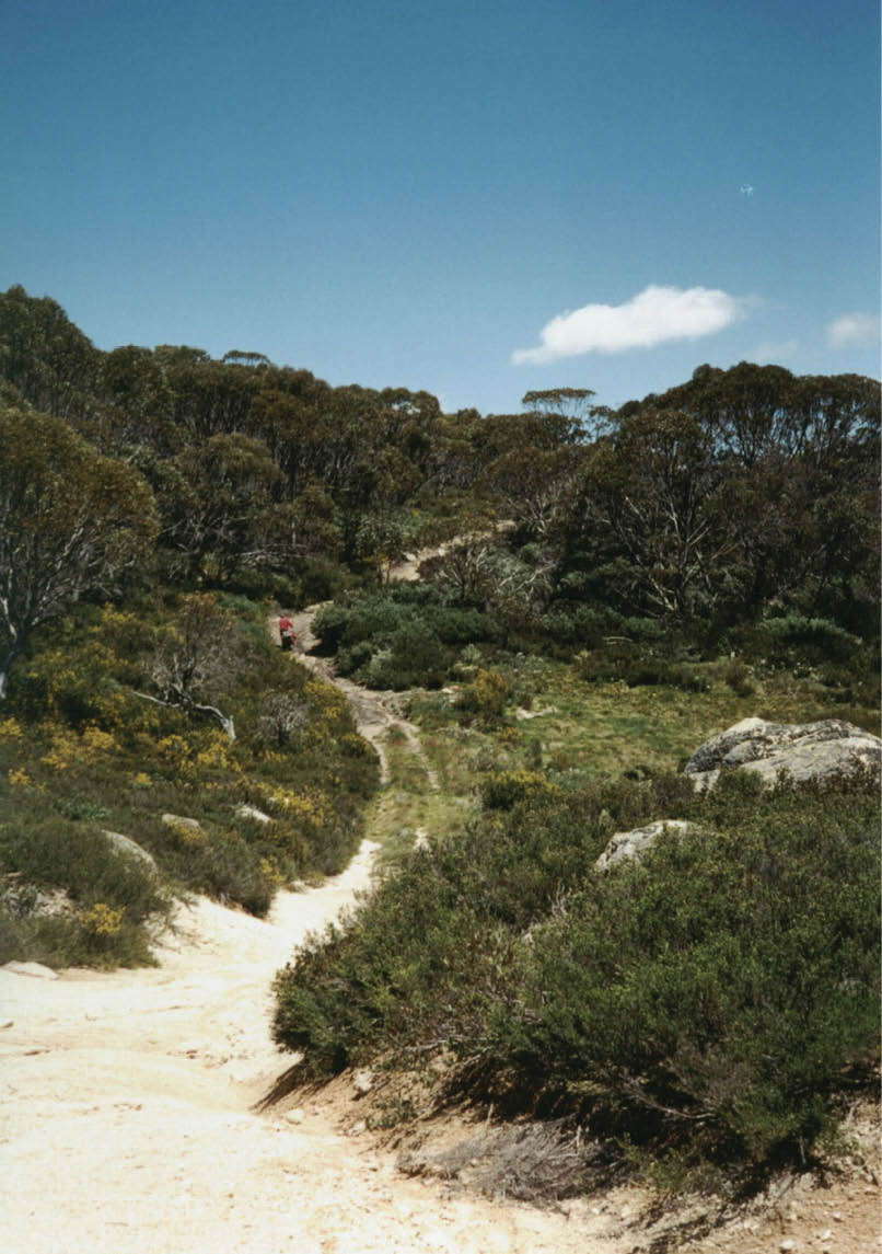
Snakey Plains FT, December 1999Pam Olson
58 | BWA April 2016
Since our first cycling trip to Kosciuszko National Park (KNP) in 1999, we have revisited KNP and the high country of ACT, NSW and Victoria a few more times. While cycling in the bush is great fun, as we have gotten older, we have found that cycling on the highways to get to the back roads has become increasingly scary because of the vehicular traffic. Since we are long-time mountaineers and hikers, a bushwalking holiday was an obvious choice.
Our introduction to KNP was during a bush ride in December 1999. Just before Christmas that year, we left Khancoban pedalling toward Cabramurra on loaded mountain bikes. We stopped at Bradneys Gap picnic area for a rest and to check our route. There was something about the road surface or our tyres that seemed to make for slow progress; we felt like we were riding in glue. One of our maps showed Everards FT joining up with Dargals FT then rejoining the road to Cabramurra. It looked like a more interesting route than the highway. Everards was steep and we had to unload the bikes and carry our packs up the steepest parts. The only thing more difficult than riding a loaded bike uphill is pushing it. We amused ourselves by trying to remember the words to Dylan’s “Positively 4th Street”.
The first night we camped on Everards Flat next to Khancoban Creek, a peaceful spot with a view of the cascade on Waterfall Creek. In the morning we filled all our water containers. Between the two bikes, we had about ten litres of water. Our intention was to camp in the snow gums and were not sure of the availability of water on Broadway Top. However, just as we got to a lovely camping spot, we could see dark
thunder heads building so we beat a retreat down to the Tooma River. The river was fairly shallow and we could easily have waded across it carrying our bikes but foolishly, we did not cross. We were somewhat naive at the time about Australian mountain storms. We sat in the tent for about 18 hours listening to the rain and thunder.
When the rain stopped, the Tooma was a raging torrent. There was no way we were going to get ourselves and our bikes across it. We looked at our 1:50,000 Khancoban map and saw that there was a hut and a fire trail about two kilometres in a direct line from our position. It took all day but, by ferrying loads, we carried our bikes and all our gear through Spanish broom, tussock grass, wombat diggings and creeks to Wheelers Hut where we camped. The next day, we followed Snakey Plains FT out to the highway and continued on toward Cabramurra. By the time we got to the Tumut Pond Reservoir, we had ridden off our map and realized the town
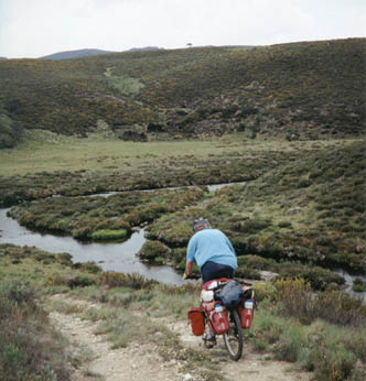
Dargals FT, descending to Tooma River crossing, December 1999 Pam Olson

Part one: Bikes up the Dargals, December 1999
“... we felt like we were riding in glue.
“The only thing more difficult than riding a loaded bike uphill is pushing it.
BWA April 2016 | 59
was up a long hill and that we were not going to get to the shop before it closed at 5:30 pm. But that is another story.
During our first few walks in Namadji National Park and KNP in early 2016, it took us a while to get used to the idea of walking along a road. In the mountains of Vancouver Island where we hike, sometimes there’s a remnant of an old logging road, but more often, if there is a trail, it was built several decades ago by an outdoor club. In places, it might be a bit overgrown. Above the tree line, usually there’s no defined trail but it is obvious where to go as the vegetation on the rocky ground is sparse and low growing. Large areas are often snow covered, even in late summer. By that time, the snow is well consolidated and makes for easy walking on the level, step kicking on uphill sections and boot skiing downhill sections. Ice axes are useful on Vancouver Island but for Australia, we armed ourselves with a walking pole each.
Getting used to walking through old pasture land took a while. When we had cycled on fire trails, because our focus was mainly on the road we had not been as aware of the surrounding landscape. When walking, one has time to look around without worrying
about skidding on a patch of loose gravel or avoiding a snake. The scarcity of trees on the higher slopes and ridges was somewhat disconcerting. The early white settlers were unaware of the long-term consequences that would result from the practice of grazing cattle and sheep on the sub-alpine and alpine grass lands, a practice that was carried out from the mid-1800s until mid-1900s when conservationists became concerned. Whereas Australia had to re-invent the idea of wilderness by turning old grazing areas into parks, there’s plenty of undisturbed wilderness in the high mountains of Canada.
We frequently hike in BC's oldest provincial park, Strathcona Provincial Park, established in 1912 on Vancouver Island. Its boundaries were determined by what the members of the Geological Survey of Canada party could see when they made the first ascent of Crown Mountain. Since then the boundaries have been moved to accommodate forestry and mining interests and the Park has been fiercely defended by environmental groups
In the Dargals, December 1999Pam Olson
“Getting used to walking through old pasture land took a while.
60 | BWA April 2016
to keep commercial operations out of it. There is a working mine within the Park and a ski resort at one edge. There are some hiking trails but much of the Park is untracked wilderness. The highest peak on Vancouver Island, The Golden Hinde (2195 metres) is within the Park. While its elevation is comparable in height to that of Mt. Kosciuszko (2229 metres), it is a more remote peak and to make the climb enjoyable, many climbers and hikers allow a week to do the summit and return.
The grid system used for Australian topographic maps was unfamiliar to me. In some 40 years of mountaineering and hiking I have navigated using geographic coordinates (latitudes and longitudes). Canadian topographic maps have both geographic coordinates and UTM grid coordinates. While I am aware that many mountaineers use GRs, I had never bothered to figure out how to determine them. My GPS was preset to WGS 84. On an earlier trip at Tin Hut we met a walker from Albury who told me to set my GPS to UTC and it would save way points as GRs. Well that was easy. Then using my topo maps, I entered several GRs into my GPS to mark significant points along the routes we were planning to take. We did not expect that we’d get lost on the obvious tracks, but it is useful to know where we are in relation to other reference points.
While we were aware that thousands of people walk to the summit of Mt. Kosciuszko annually, we were a bit surprised by the crowds at Charlotte Pass when we were on our way to Mt. Townsend earlier in our holiday. Just as we started out, a group of about 30 teenagers surged along the track, herded by a few adults, one of who had a drone camera and was filming the expedition. One boy was carrying a cricket bat. We soon caught up to the group, at the Snowy River crossing where one of the herders had her first aid kit out and was tending to a girl who had fallen and hurt herself. We veered off the track and headed for the Twynams by way of Hedley Tarn. I wonder if all those people going to the top of Mt. Kosciuszko think there is a paved walkway to the tops of all mountains.
To be continued in BWA June 2016. Pam tells the story of their 2016 trip to Jagungal.
Pamela Olson lives in British Columbia, on the Pacific Coast of Canada. She began rock climbing and mountaineering in the mid-1970s and did most of her serious climbing in BC ranges during the 1970s to 1990s. Pam and her partner spend their summers walking up and down mountains on Vancouver Island where they live. During the winters, they try to escape to the antipodes for cycling and hiking holidays.
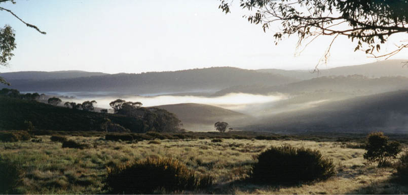
Sunrise at Wheelers Hut, December 1999Pam Olson


“I wonder if all those people going to the top of Mt. Kosciuszko think there is a paved walkway to the tops of all mountains.
BWA April 2016 | 61