

It’s midnight and I’m on the summit of Mount Giles, listening to the wind gusting around my tent fly. Actually, it’s not the wind I’m worried about, it’s the suggestion of a pitter-patter on the material above my head. Trying to avoid my painful bruises, I turn over and stick my hand out into the chilly darkness. It’s dry this time, but the next test shows it’s starting to rain. The weather has been building all day and is only likely to worsen.
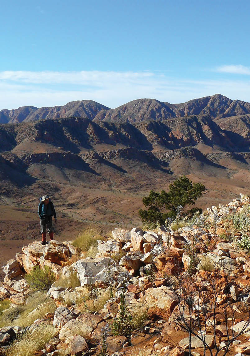
Steven Robinson above Ormiston Pound. The 2014 trip went from the left on the skyline Chewings Range to Mount Giles on the right. Meg McKone

More Than One Way to Climb Mount Giles
Meg McKone

6 | BWA April 2020
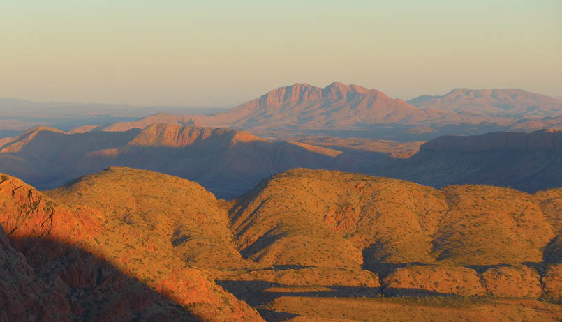

Dawn on SonderMeg McKone
This is not what I’d envisaged. After two weeks of sleeping most nights under a canopy of stars progressively dimmed by the waxing moon, I’d hoped for just one more clear night, once more to watch the sun set and the full moon rise from this desert vantage point. But aesthetic considerations are fading fast as I face the practicalities of finding the southern spur off the mountain in the rain when I’ve only climbed this spur once, 34 years ago. Back to sleep, to see what the morning brings.
***
Mount Giles, 1389 metres, is the third highest peak in the Northern Territory. It’s about 120 kilometres west of Alice Springs near the end of the Chewings Range, a few rises before it falls away into Ormiston Pound. Yet the range does not disappear, for ancient geological forces have twisted it first north, then west, to form the walls of Ormiston Pound and Gorge, above which rises the serene beauty of Mount Sonder, floating on a haze of blue. It is this magnificent view which makes the peak such a worthwhile destination, and once having ascended it by the most easily accessible southern spur, there are other, more challenging routes to attempt.
Note: Since few of the geographical features in the West MacDonnells have been named on the official maps and it has not been possible to obtain their Aboriginal names, I have used unofficial names where I have been unaware of any other names, putting them in inverted commas at first use.
The 1980 and 1989 tripsMy first ascent was in August 1980, with Frank and Joan Rigby, veterans of West MacDonnells bushwalking. We started out from Serpentine Gorge and after an exploratory day walk up onto the Chewings Range from Giles Yard Spring and back, we continued westward to the base of Mount Giles. Leaving our spare food in a tree, safe from dingoes, we climbed the steep spur to the summit, where we cleared a few sleeping spaces among the rocks before eagerly awaiting the sunset. We weren’t disappointed. As the colours changed from daytime rusty browns to brilliant reds and purples, indigo shadows etched sharp-edged gullies into scalloped ridges. I turned around and caught my breath, for in the east a huge full moon was rising over the range. This was something that I had to see again, sometime, especially when I found that my
“Mount Giles, 1389 metres, is the third highest peak in the NT.
“I turned around and caught my breath, for in the east a huge full moon was rising over the range.
BWA April 2020 | 7

moonrise photos were blurred. Next morning the rising sun spread a golden glow across the landscape. Then we had to find our spur again for the descent, which was not at all obvious from above. I was glad that Frank and Joan were there to lead us safely down.
My next trip to the MacDonnells was in July 1989 when we walked a circuitous route from Redbank Gorge to Serpentine Gorge. We were keen to spend some time on the northern side of the Chewings Range, more difficult to access than the southern side and in general steeper, redder, rockier and more rugged. After climbing onto the “Red Wall” from Bowmans Gap and walking half of it, we cut through the gap behind the Red Wall and circled around to the “Mini-Pound” on the northern side of Mount Giles. After a fruitless attempt to find the entrance to a spectacular canyon I’d seen from the top of the Chewings Range nine years previously (we explored it in 1992, calling it the ”Canyon
of Defiance”), we camped in a creek bed as the sun set the cliffs aflame. The Mini-Pound is often dry, but rain the previous day had filled a rock hole hidden in the scallops of the rim between Ormiston Pound and the Mini-Pound.
A direct route climbing 400 metres up the extremely steep north face of Mount Giles didn’t look like a goer, so we climbed up onto the rim first and sat for a while, marvelling at the spectacular buttresses sweeping down into Ormiston Pound far below. If you climb Mount Sonder, you will see similar buttresses on its eastern face. There was still a big climb ahead, first up to the corner then a change of direction and over some calf-wrenching knolls until at last we stood at the summit cairn. This time we weren’t camping on top. After traversing the summit ridge eastwards to the next big saddle, we decided to drop off the range down a creek heading south. It provided quite good going at first but had some heart-stopping drops lower down in a gully overhung with rotting bollards of rock which threatened to topple over at any moment and join their fallen mates. We
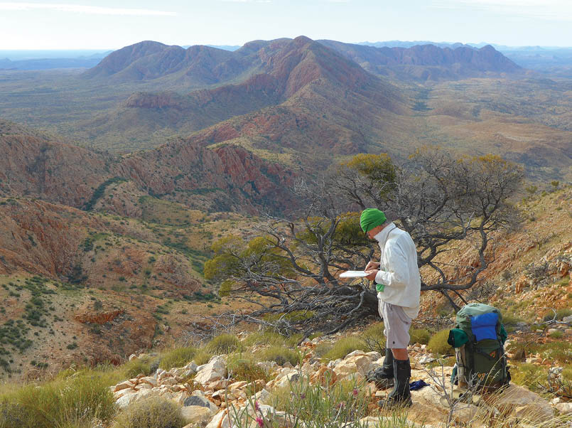
Geoff and the view east on the Chewings Range above Upper Giles Yard SpringMeg McKone
“It provided quite good going at first but had some heart-stopping drops ...
8 | BWA April 2020

finally made it safely to the bottom where we found a pleasant campsite close to water. It was not a route I would recommend.
The July 2014 tripAs the years passed, the thought of spending another night on Mount Giles was becoming more beguiling, though if I didn’t do it soon by the approach that interested me most, it would be beyond me. In 1999 we had climbed Mount Giles in a long day from Giles Yard Spring, walking seven kilometres along the crest of the Chewings Range and back – a spectacular route though a rugged one, with deep saddles, exposed arêtes and punishingly sharp rocks underfoot. Now, 15 years later, I hoped I could manage it just one way, carrying water and gear for overnight on the summit, and descending the next day down the popular southern spur.
Our party of four set out from the Ochre Pits on a superb fine day, one in a run of cloudless skies with little or no wind. The track through Inarlanga Pass joins the Larapinta Trail, which we followed briefly until we could turn into the gap in the northern ridge of the Heavitree Range. I had barely stepped off the trail when I became aware of a snakeskin with an unusual yellow and green diamond
pattern at my feet. But snakeskins don’t puff themselves up, flick out their tongues and hiss! Startled, I took a few steps backwards, whereupon the snake subsided and slid back under a rock. I later identified it at the Alice Springs Desert Park as a highly poisonous mulga snake, rarely seen during the winter months.
Once through the gap, we climbed a low ridge whose northern slopes merge into the broad valley which ends abruptly in the great blue barrier of the Chewings Range, stretching right across the horizon ahead. The Giles summit is just another bump on that long ridge, identifiable by its inverted V shape unlike its more rounded neighbours. I studied the steep spurs dropping off its southern face, knowing that I would have to select the correct one for the descent if we were to avoid being cliffed. I’d consulted John and Lyn Daly’s Take a Walk in the Northern Territory to work out which of several possible spurs it could be (their mud map proved most useful as it identified the creeks, and so by default the spurs), and had written out their ascent instructions in reverse.
Also identifiable was the deep cleft of Giles Yard Spring, seven kilometres to the east of Mount Giles. Camping has been banned at the magnificent pool and waterfall to protect the rare ferns, and a camping area has been
Sometimes it was easier to sidle the steep Chewings Range knolls than to go over the top. Geoff at the top, Kerri-Ann and Ute at the frontMeg McKone
“But snakeskins don’t puff themselves up, flick out their tongues and hiss!
BWA April 2020 | 9
set up some 500 metres downstream. We left early the next morning, glad that there was no need to collect our water for the night on the summit at the Lower Spring, for 200 metres from the top of the range in a shallow valley lies a hidden gem – a reliable spring with several pools of good water from which we each packed five to six litres.
The first few kilometres along the tops were relatively easy. I’d done this section several times as part of an intricate high-level route to the mouth of the Canyon of Defiance on the northern side of the range, but soon the going became much tougher with the rugged terrain requiring constant vigilance. At lunchtime my eyes were wandering idly over the rise ahead when I realised with a sudden shock that it was surrounded by a vertical wall of rock. Fortunately, as we soon discovered, hidden behind a section of cliff was a steep, rocky gully, just climbable with our heavy packs. But with the difficulties came spectacular rewards. At a rounded knoll where the range does a dog-leg to the south, amazing views unfolded – one east along the jumbled peaks of the winding range to the top of Hugh Gorge and beyond; the other west across Ormiston Pound to Mounts Sonder and Razorback, the Red Wall, Bowmans Gap and Mount Zeil. Perhaps this would be the best place of all to view the sunset – after time spent clearing sleeping spaces in the rock-strewn ground.
The summitAt mid-afternoon we were making steady progress, expecting to reach the summit in time to set up camp well before sunset, when I stepped onto a projecting lump of rock. It broke, and I went arcing through the air before hitting the ground head-first in a jumble of sharp quartzite and spinifex. I lay there for a minute, taking stock of the situation. Yes, my head was bleeding profusely, but I was still conscious. Yes, I had deep bruises along one side, but nothing seemed to be broken. I called to the others and by the time I’d wrestled my pack off my head, they arrived, bearing a first aid kit. Kerri-Ann wiped the blood off my face and Geoff took my pack while I made a few tentative steps. One forearm was very weak, but it had recovered by the next morning. The only lasting damage was a hole in my wonderfully comfortable, brand-new One Planet pack, purchased on the spur of the moment a few weeks previously at the Lone Dingo in Alice Springs.
The afternoon wore on as I dragged myself up, down and across a seemingly endless number of peaks. The day had begun with a few pretty streaks of pink cloud. By the time we saw the summit cairn, evening was approaching with a thick grey blanket obscuring the sky and the sunset merely a thin, pallid bar across the western horizon. The moon didn’t put in an appearance at all. Due to my status as an Injured Person, the others offered me the best of the cleared tent
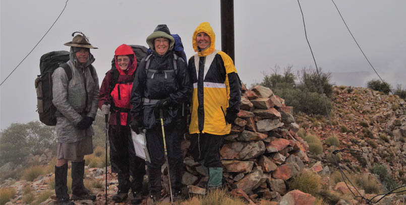
Our 2014 party at the summit of Mount Giles, about to descend into the mist. L-R: Geoff Jones, Ute Foster, Meg McKone, Kerri-Ann Smith. Kerri-Ann Smith
10 | BWA April 2020
Meg began bushwalking with her family at an early age in national parks around Sydney and joined the Teenage Section of Coast and Mountain Walkers in 1959. In 1973 she moved to Canberra where she joined the Canberra Bushwalking Club and taught in secondary schools until her retirement. Her favourite bushwalking areas include the MacDonnell Ranges, the Blue Breaks in the Southern Blue Mountains and the Central Queensland highlands. She especially enjoys leading exploratory walks and pioneered trips into the Canyon of Defiance and Portals Canyon in the West MacDonnells. She is very concerned by recent threats to national parks including feral horse protection, damming of wild rivers and private developments which exclude the general public.


sites. I took the first I saw, weighted my tent pegs down with rocks and crawled inside just on dark without even visiting the summit, 10 metres away.
***
At dawn I peer out of the tent. Though it’s raining lightly, the ridges are still visible. We need to get out of here quickly, and it’s time I located the rest of the party. Geoff and his tent look quite sprightly. Ute’s tent, erected on a tiny spot, is drenched and droopy and I wonder if she’s stayed dry. Kerri-Ann is sitting up smiling as usual though her open tarp is twisted beneath a bush. I stagger up to the summit and look at the book. There seems to be some sort of competition going on as to who can climb the mountain fastest. I write something incomprehensible and return to my tent to pack. Job done, I look around and my heart sinks. The mist has come in.
The start of the descent is obvious – west, then southwest over a few saddles and down to a big cairn. Here we veer left and descend 70 metres to the top of several possible spurs. I select one of them and waste time climbing down then up again, peering into the mist, trying to judge the terrain on either side. But right or wrong, it’s time to make a firm decision. Geoff goes first to select the best route over the angular, slippery boulders of our chosen spur. When Ute points out one cairn and then another, I almost weep with relief. A hundred metres from the bottom we emerge from the fog; never has a valley looked more beautiful. We lunch in a creek bed standing up in the rain, then start our freezing march across Ormiston Pound. Our original plan to camp in the Pound is not even mentioned, it is so obvious that no one wants to spend a night out with sodden clothes in a wet tent. We reach the Visitor Centre just on dusk – our second nine hour day. Despite our parkas and thermals, we’ve been cold and wet all day, with only constant activity staving off hypothermia.
Postscript: The 2015 tripThough I baulked at climbing Mount Giles again, I was determined to capture those sunset and sunrise moments, with or without a full moon. In August the following year, we climbed to the top of the Chewings Range up Pats Canyon, next to the Canyon of
Defiance, on the northern side to camp on the “Dog Leg Knoll” with its amazing views. After spending an hour or two clearing rocks for sleeping spaces, we rugged up against the chilly wind and waited. A magnificent sunset came and went, leaving us the hours of a largely sleepless night to appreciate the stars blazing away in a moonless sky as the wind pushed icy fingers into our sleeping bags. I was up at the first inkling of dawn, watching the light gradually create the landscape anew from the murky darkness beneath me. At last the sun shot bolts of brilliant colour across the country, highlighting the magnificent scenery at the western end of the Chewings Range. Though Mount Giles itself was out of sight behind another bump on the range, our alternative campsite had given us rich rewards.
NB: Permission is needed from the Parks and Wildlife Commission of the Northern Territory to camp off-track in the West MacDonnells National Park.


BWA April 2020 | 11