

This is not the type of walk I would normally do; I guess I was Three Capes curious though. A spot became available while I was in Tassie, so I thought I should give it a go. I loved it, way more than I expected.
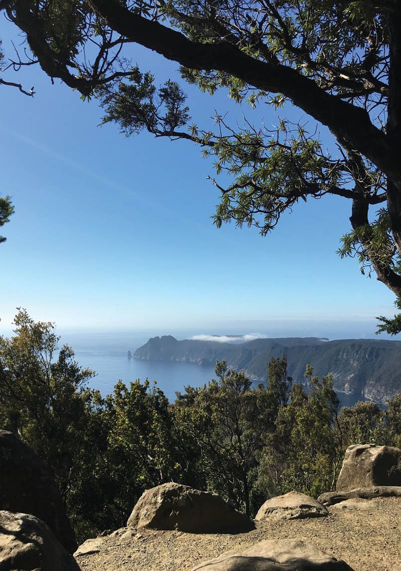
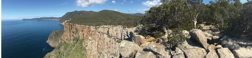
Looking towards Cape Pillar 2 kilometres north-east of RetakunnaAll pictures by Matt McClelland

Three Capes
Surprisingly Fun
Matt McClelland

6 | BWA June 2020
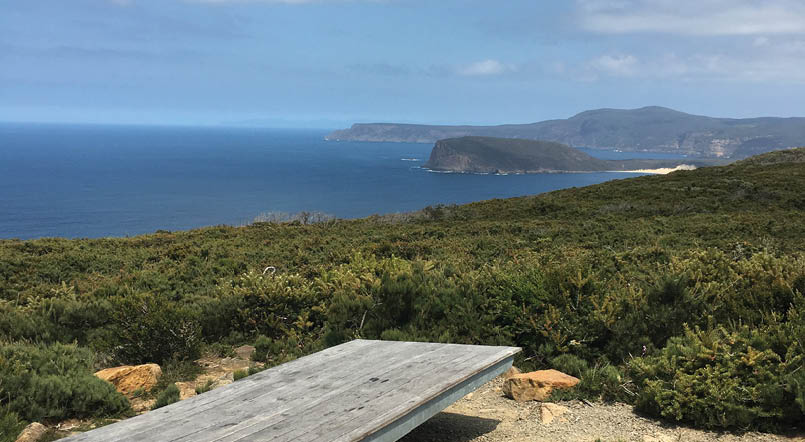

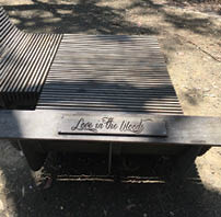
Seats have names, and this one is called Where the 'ell are we?!, looking at Cape Raoul.
The Three Capes walk has been controversial among bushwalkers for many good reasons. I do not like the idea of having public land closed to people unwilling or unable to pay the large extra exclusive use fees. There are many concerns around this style of walk on public land; we have spoken about them and we should continue to raise these concerns. However, it is clear that this is a very popular walk with booking numbers very high, so I wanted to join in and get a sense of what the experience was like.
Overview of the walkThe walk starts from historic Port Arthur, in the south-east corner of Tasmania, with a boat ride to the start of the track at Denmans Cove. The walk is 48 kilometres long, taking three nights and four days to complete, visiting the spectacular Cape Pillar and Cape Hauy.
The accommodation is in shared rooms, luxurious by bushwalking standards and quaint by general community standards. There is a toilet block in a separate building (the second night has two outdoor showers) and there are shared kitchen and dining rooms. The buildings are well set up for either sitting outdoors or indoors and you can be as social or introverted as you like (but you will need to share a room). The kitchen areas are well equipped with stoves, sinks, pots, pans and cooking utensils. There are also LED lighting and 5 volt USB charging ports in the common room.
Okay, let me get this out of the way, this just bugs me and I need to get over it. The walk is called “Three Capes” but it only visits two capes. The third cape is Cape Raoul, not part of the formal walk, but part of the original plan. You can do the day walk to Cape Raoul before or after the main walk. The current walk is a good route and four days is plenty for most people. So the name “Three Capes” is just weird.
BookingThis walk is very popular in the warmer months and needs to be booked at Three Capes Track well in advance for the 48 places a day, especially for larger groups or if you want a specific day. People do cancel and the odd place becomes available last minute. As I finished the Overland Track I checked the website and noticed a spot available only few days later, giving me enough time to walk up the Arm River before resupplying and heading down to Port Arthur. So if you are in the area and don’t have a booking, keep an eye out - you might be lucky enough to get a place.
It ain’t cheap: $500 for an adult and $400 for kids and concessions. For a family, this adds up very quickly, but it does provide a unique experience that I felt was well worth the money. The fee includes the boat ride, accommodation (including kitchen
“The walk is called “Three Capes” but it only visits two capes.
BWA June 2020 | 7
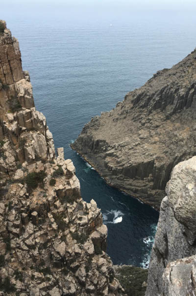


Crevice on Cape Pillar
facilities), track upkeep and a ranger at each cabin. More importantly, it provides a safe and achievable multi-day walking trip for people who do not have the experience, fitness or gear to do other multi-day walks. This means you can walk at your own pace, and do not need to rely on a guide for setting a pace. I am not a guided walk kind of guy; I know some people love them and that is great.
The walk will cost you much more than the booking fee - there are travel costs, food and possible gear if you are not already an overnight walker. I met a bunch of people on the track who had travelled to Tassie just for the walk, with a few days either side as a buffer, spending several thousand dollars for the experience - and they loved it.
Preparing and packingFor an experienced bushwalker, this is an easy prep and pack job – it feels weird having a half-empty pack though. For first-timers to the overnight walking thing, the better you prepare the more you will enjoy the walking.
You do not need a tent, sleeping pad or cooking equipment. You do need a sleeping bag, pillow, food, eating utensils and washing up gear as well as the standard stuff like clothes, rain jacket, first aid kit etc. When you book you get a full packing list.
The packing information from the Parks and Wildlife Service is generally helpful but lacks a few things. Mainly it recommends people carry freeze-dried meals. The kitchen facilities are very good and there are much better meal options that can add to the overall experience. On my trip at least half the people were eating freeze-dried meals, and not enjoying them. Also, about half had very poorly packed and poorly fitting
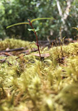
Fern trees north-east of Retakunna
“... it provides a safe and achievable multi-day walking trip for people who do not have the experience ...
8 | BWA June 2020

Sunset over Port Arthur and Cape Raoul from Surveyors Hut
packs, making walking very uncomfortable. I became the pack fitting guy, which was a fun way to get to know people better, but it seems to be such a common issue that if resolved would improve the experience for so many people.
Since I had just spent 12 days on track before heading down to the Three Capes, I was pleased to get my laundry done (thanks Karen) and spent 30 minutes at Colesworth getting my meals organised. Sated tandoori chicken on coconut rice, cheese tortellini with vegies/tomato-based sauce then chicken risotto for my last night. My pack total weight was under 10 kilograms and I massively over-catered, but plenty of people were happy to help finish off my leftovers.
To be or not to be social, that is the questionI love meeting new people on track. Most walking I do is solo but in the evening I enjoy hearing other people's stories and seeing how they are travelling. Most of the time on this walk I was walking solo, making an effort to slow my pace, otherwise it would be too easy to be at camp by lunch. Some people were up walking just after sunrise to maximise that alone time.
I carried extra snack food to encourage an evening happy hour. A big packet of chips, a wheel of cheese (frozen at the start), crackers, and quince paste each day added about a kilogram to my pack. This is pretty normal for me, usually having popcorn or something to share to get conversations started. After meeting a few people I set up on a picnic table and invited them to join me, encouraging others to join in as we go. Over the next few days, people started to scrape together a few extra bits and it became a lovely small community. The stories that came out were great and the collective wisdom supportive of those struggling on track. This may then transition into a game of cards, a stroll for sunset or just finish up.
Other things might get you more excited such as photography, writing, exercise, sleeping, or maybe vlogging. The point is - be prepared. This walk gives you the time and pack space to immerse yourself into things that you might not get the chance to on other walks.
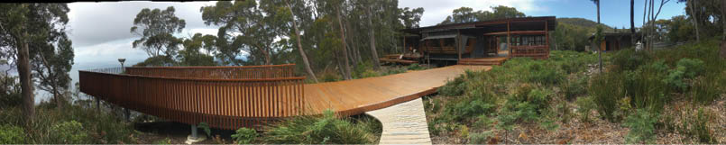
Lower deck at Surveyors Hut
“I carried extra snack food to encourage an evening happy hour.
BWA June 2020 | 9
Kitchen at Surveyors Hut
FacilitiesBedroomsThe rooms sleep either four or eight people on single bunk beds. There are no couples rooms, so it's not the best walk for a romantic getaway. The rooms are allocated before the walk, and if you are in room five on the first night you are in room five for the next two nights with the same people. If you want to bunk with another group booking on the same day, make it clear in the notes. The parks staff do their best to keep groups together and match people well.
The rooms are basic but comfortable, and each bunk has a vinyl-covered mattress. There are pegs outside undercover to hang up wet clothes. There is no lighting, but a sealed window as well as a door, with an optional screen door gives light.
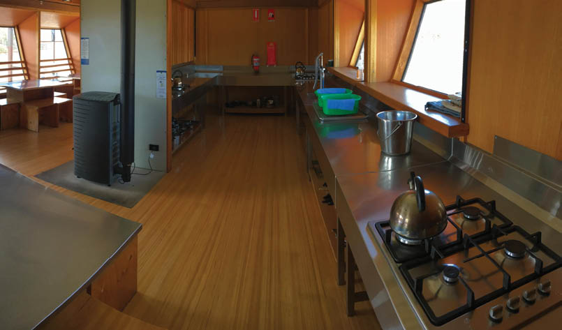
KitchenThe kitchens are very well set up: normal kitchen gas cooktops, plenty of pots, pans, cooktop kettles, and cooking utensils, including chopping knives and chopping boards. There are no ovens. The sinks have a pump tap and plugs so you can add hot
water from the stove for washing up. There is handwashing and washing up detergent, and scrubbers - but you are best to bring your own small tea towel. There are BBQs in the alcove areas.
On my trip people did well keeping the place clean and there there was a lot of positive sharing with people heating water for others as well as sharing of spices and other ingredients. Most people were good at washing up and keeping the areas clean.
The water comes from rainwater tanks. Most people seemed to drink it directly, and some people treated it. You will also find the USB charging station in the kitchen to share with other walkers.
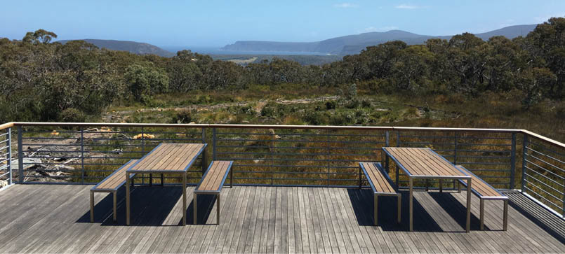
Common roomsThere are one or two separate common rooms next to the kitchens. There are picnic-style tables for eating, playing cards or reading. In warm dry weather, many people used the outside tables or just sat on the steps. There are also sunbathing-style beach chairs for those one or two sunny Tassie days.
The common rooms have maps, books and board games for sharing. My experience was that family groups seemed to spend most of their time using the common rooms.
“The parks staff do their best to keep groups together and match people well.
10 | BWA June 2020

Toilet blocksEach of the accommodation areas has a separate toilet block with four pit toilets. These are a short walk away and also have hand washing basins and mirrors outsides each toilet cubical.
There are also undercover clotheslines with drying pegs. If your clothes get wet wring them out, then wring with a microfibre tea towel to remove most of the water to give them a chance of drying out fully.
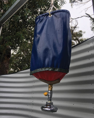
Munro (night two) has two outdoor bucket showers. They are shielded with corrugated iron walls and no roof. You fill a bucket with hot water then add that hot water to the shower bucket and hoist it up. The shower lasts about five minutes. This is a nice novelty for a walk and works well.
Just one point for the less agile who get up for toileting during the night. At Surveyors (night one) and Retakunna (night three), the toilets are about a 50 metre walk from the rooms. Weirdly, at Munro (night two), the toilets are a 170 metres (340 metres return) walk. One person on the walk I was on struggled with this and we discussed other ways of emptying bladders overnight and disposing of it the next day. There a bunch of privacy and dignity issues around supporting
walkers with continence issues, many of whom would otherwise be attracted to this style of walk. Also, there are only toilets at the three cabins (there are few campsites near Munro with toilets, but close-ish to the cabins). So if you have continence issues you will need to plan for this.
Track conditionThe track is very (like ridiculously) well constructed. There is a significant amount of boardwalk between stone steps, very little erosion and the track is well maintained. The route is beautifully designed. bringing you very close to cliff edges, with no fences. There are about 10 significant hills (around 100 metres vertical climb each), and one (Mount Fortescue) over 200 metres climb on the walk, so people not used to walking would enjoy the walk much more if they do some training with packs beforehand. The walk is accessible to most people with average fitness and agility.
There are very few signs, with most of the wayfinding being very obvious - it really is well designed. The only time you will scratch your head is leaving the cabins in the morning - the track is weirdly designed to make it look like you walk back the way you came, so check your map or with the ranger about which way to go.
Shower bucket at Munro Hut
Well formed track leading past Dear Eliza seat
BWA June 2020 | 11

RangersEach cabin has a ranger. The ranger makes sure that everyone arrives safely and can help people who are struggling. They do a briefing each night, varying in quality from awesome to okayish. One ranger got enough people very excited about wildflower spotting so that about 25 of us spent the next hour roaming around to identify the local flowers - it was fun. On day three one of my fellow walkers injured her ankle, and we discovered that the ranger had a freezer with ice packs. Ask the rangers if you need anything; they were really good. During the day the rangers do cleaning and track maintenance
Interpretation on trackI am not one to stop and read interpretive signs (interp) on track. I usually take a photo thinking I will read it later, and usually don’t. My wife stops and reads every sign. Generally speaking, I think the way they organised interp on this walk was very clever. Each walker is provided with a copy of Encounters on the Edge and most of the interp is in the booklet, which is your guide for the walk. Encounters gives you a good introduction to the walk, maps and a series of interp stories for each section of the walk. It is a well produced colourful booklet. It would be nice to have an online version to read before you leave home, but they give you this paper copy as you check in at the start.
There are minimal signs along the walk, which works well. The booklet provides some information on navigation but is mostly about getting a sense of the area and history.
My only real bugbear is the very little information about the traditional owners the Pydarerme people. The Pydarerme people are acknowledged but very few stories are told of their life or the plight of the people following the arrive/invasion of Europeans. Some of the accommodation cabins are
named using Pydarerme names for animals of the area, which is a nice touch, but so much more could be done.
Now I have that off my chest, the interp system is unique and clever. There is a series of 27 seats spread along the walk, each with a very corny name, and the corniness works well. Each seat has a short story attached to it that you read from your booklet. Most stories focus on the life of European prisoners during the 1800s or on the geology/ecology of the region. The stories are short and interesting. Since I am clearly not much of a reader, I loved it when I came across a group of people at the seat where one person was reading the story out loud - it was a cool vibe. I think a series of short podcasts to listen to as I walked, or the night before each section would have worked better for me. I must say that way more people engaged with the interp system than I see on other walks.
Oh, and one more whinge. The booklet has a pretty good map and terrain profile. For some very confusing reason, the key features marked on the maps are the interp seats but on the terrain profile, the labels are for natural features. These natural features are not signposted on the track. The terrain profile would give most visitors the best sense of progress if labelled with the seat names. It was surprising how many people had no idea how far they had walked most days. Many people ended up walking faster than necessary, worried they were walking too slow, and getting into camp way earlier then they hoped. Some simple progress-based navigation aids would help non-bushwalkers.
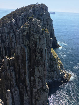
The view from Cape Huay to Cape Pillar
Love in the Woods seat
12 | BWA June 2020
Day by day overviewDay 1 - Denmans Cove to Surveyors, 4 kilometres, flat, 2 hoursYou meet the Three Capes office area at the Port Arthur Visitor Information Centre 90 minutes before your boat departure time. For me, that meant getting there by 10 am. Aim to get there as early as you can (or get the later boat), leave your pack at the check-in and take the time to explore Port Arthur before jumping on your boat.
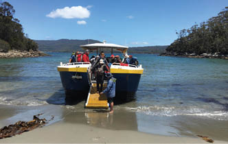
I was sceptical of the boat ride as it just seemed weird to me, but it worked. You jump on board and stow your pack under a seat then put on a big poncho to deal with sea spray. They take you on an one-hour tour giving you some background to the geology of the area. If the swell is low then they duck out of the heads and give you a sense of the terrain for the next few days, including a view out to Tasman Island and Cape Pillar.
The boat then lands on the Denmans Cove beach and you exit via a lowered ramp at the bow. The staff on the boat managed to get everyone onto the beach with dry boots.
It is a gently undulating walk to Surveyors Cove, where I had lunch on the bouldery beach. From here the track climbs to Surveyors, a four kilometres walk for day one. This day took me less than two hours including a long lunch trying to take it as slow as I could.
I ran into a couple whom I met on the Overland Track only a few days before. This was fun and I got to meet a few fellow walkers.
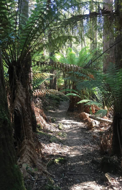
Day 2 - Surveyors to Munro, 11 kilometres, undulating, 4-4.5 hoursThe walk to Munro on day two is quite easy. There are a few climbs and a bunch of seats to stop and enjoy. There are some good clifftop views, but my favourite spot was the “cloud forest”, a unique microclimate wet forest at the top of the cliffs. After climbing out of the ferny forest you come to an area rich with fungus, mosses, lichens and other rainforest plants that seem so out of place compared to what we had walked through so far.
Munro is a large accommodation area, with a spectacular lookout platform and larger single kitchen. Ohh and the shower. I did not feel I needed one (although fellow walkers may have disagreed and were just polite), so I had a shower for the novelty factor and it was nice to freshen up.
Boat arrival at Denmans Cove
Surveyors Hut
Moss in Cloud Forest
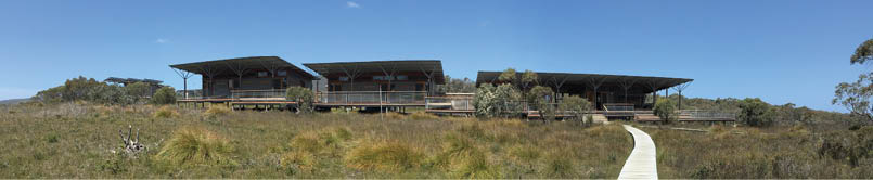
Munro Hut
BWA June 2020 | 13


Day 3 - Munro to Retakunna, 19 kilometres, 1300 cumulative metres ascent, 6-7 hoursA unique day. You pack up and leave your main pack in a purpose-built shed out the back, do the return walk to Cape Pillar and back to Munro with a daypack (and lunch), about 15.5 kilometres return. Then with your full pack you walk 3.5 kilometres to Retakunna, mostly retracing the last few kilometres from day two.
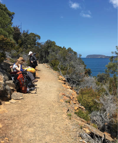
I enjoyed this day more then I expected. I am not a big fan of return walks, but with a day pack and all the time in the world to just wander it was lovely. All the action happens towards the tip of the cape, with some really nice clifftop views, with special views over The Blade and The Chasm. As well as seeing Tasman Island from a bunch of different angles as you work your way along to the cape. On this section of the walk you will see
some day walkers and a few other overnight walkers not part of the your group of 48. As you head back through Munro and on to Retakunna, you will likely see some walkers in the next group of 48.
I think this was my favourite evening. I had really enjoyed getting to know a few different people. One of my new friends had injured her ankle so there was a bit of fussing around to help her and her family get sorted. They would have worked it out, but seemed to appreciate the help. Before dinner we enjoyed our happy hour with some delightful imaginative extra additions from people's scroggins and the like. Our last night together was a chance to hear more about peoples adventures, and trepidations of climbing “Mount Fortescue” tomorrow.
Day 4 - Retakunna, Fortescue Bay 14 kilometres, 450 cumulative metres ascent, 6-7 hours
Start early and take your time. Mount Fortescue is the biggest climb, but your pack is light and there is no rush. At the intersection with Cape Hauy you can drop your main pack and wander out to the cape. Some people decided not to go, but it is really worth it. There were many more day walkers on this section of the track, and most people we had seen so far had been in our party of 48 and a few more adventurous walkers.
Cape Hauy is all about cliff edge views and amazing ocean vistas.
With the walk back to my pack and then on to Fortescue Bay I was two minds. I wanted to finish and get on with my next walk (heading back into the Cradle area for a few days) but I had also really enjoyed this area and these people I had gotten to know. To my delight when we got to Fortescue Bay there was a shelter dedicated for people
Cape Huay
Retakunna Hut
“Some people decided not to go, but it is really worth it.
14 | BWA June 2020
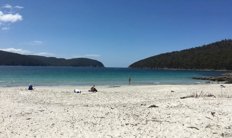
finishing the Three Capes walk. It was a lovely final meeting of the people I had walked with for the last four days, with a refreshing swim at the beach before catching the booked bus back to Port Arthur.
I must say the boat at the start and the bus at the end, as well as the guaranteed bed each night was a really nice feature of this walk. Logistically it was the easiest four day walk I have ever done.
Who is this walk good for?As I walked this track I was often thinking about who really would benefit from this walk. The mix of people on my little cross-section were mostly older people and families. Then there were a few singles and a few couples. Most of the people had some
experience walking many years ago and were keen to get back on track but without full packs. A reasonable number had never done any overnight walks. It was very cool to see family groups on the track.
For more experienced bushwalkers I would generally recommend doing the “Free Capes” version where you take all your own gear and stop at well-established campsites.
Who is this walk ideal for?
For bushwalkers to take their non-bushwalking family.
For older but fairly agile people who enjoy walking.
For families with 10-year-old plus kids.
If you have younger kids and want to do the walk it is very achievable, there are even a few cots available.
Anyone wanting to try overnight bushwalking, but not quite ready, especially if you do not have walking buddies or just like luxuries.
I was thinking about what would bring me back here. I doubt I would pull this off, but I really like the idea of booking out the track fully for my 50th birthday and seeing if I can get a bunch of friends to join in for a four days adventure. Travelling to Tassie with all the extra costs involved will probably mean I can’t make that happen, but let me dream :)
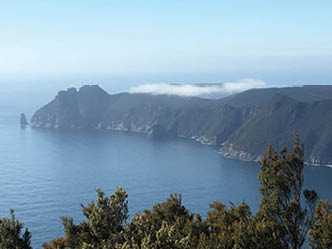
View towards Cape Pillar from the coast north-east of Retakunna
Fortescue Bay


BWA June 2020 | 15