

From canyons to grasslands, this great walk truly is gorgeous.
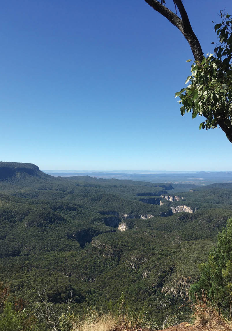
Carnarvon Gorge from top of Battleship SpurAll pictures by Matt McClelland

Carnarvon Gorge-ous
Matt McClelland

6 | BWA October 2021


6km
0
3

Visitors Centre
On a large scale view Carnarvon Gorge is just a wee little crack in the Queensland's central highlands. As I drove closer, I could pick which crack it is in the distance. As I parked my car I was impressed by the towering sandstone cliffs. And when I walked through the gorge I was swallowed up by breathtaking side canyons, Aboriginal art and history, and the sheer power of water and time. If I saw a dinosaur I would not have been too surprised.
Most of the walking I do is fairly well planned. I am not manic in my planning, but I usually do a pretty good research. But not this time. I was on the Gold Coast for a few weeks to
do a series of short walks, but the forecast was such that I looked into other options. I like blue skies, you can call me soft if you want. It was only a 750 kilometre drive to this Carnarvon Gorge, a place I have heard was good. I have enough food in the boot, so let's go.
Don’t get me wrong, there is value in researching a place before you go. I would have got more out of the trip if I had a better sense of the traditional custodial history, the geology, the flora and fauna. Oh and having a good sense of the walk would have meant I was better prepared, but I was prepared enough to be safe and enjoy it.


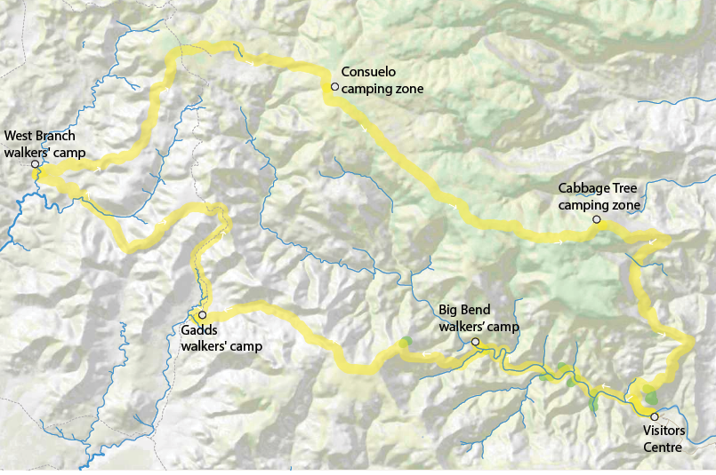
Main trackSide trips
BWA October 2021 | 7

Moss Garden
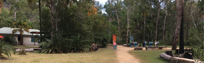
Day 1 - Visitors Centre - Big Bend walkers' camp, 9.5 km, 2.75 - 4.5 hours The walk starts with the most spectacular places to visit, it really is an awesome day. There is parking a short walk from the visitor centre, the official start of the walk. There is a pay phone, free Wi-Fi, toilets and plenty of information about the regions. It was worth spending a bit of time getting a feel for the history and landscape that I was about to plunge into.
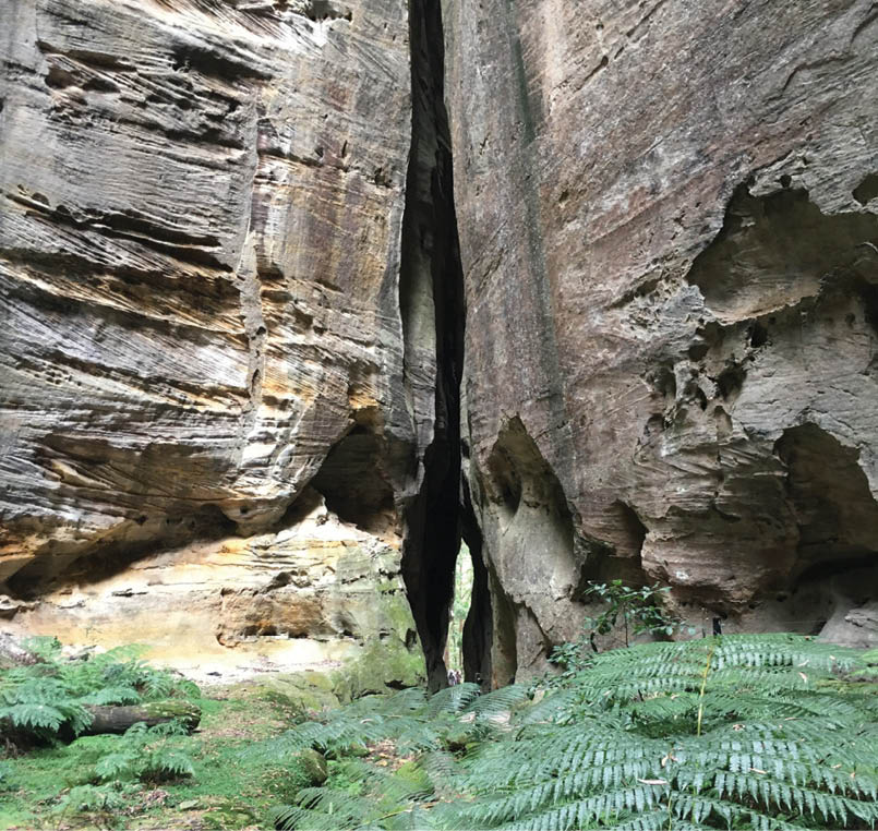
I kicked off from the Visitors Centre, following the very well maintained tourist track up through the centre of the gorge. Soon into the walk I noticed the track to Boolimba Bluff where I will come down when I finish the walk in a few days. The canyon walk is nice, but it is all about the rougher side trips to some amazing places like Moss Garden, the Amphitheatre, Wards Canyon, the Art Gallery, and Cathedral Cave.
The Moss Garden is found at the base of a waterfall in a side canyon.
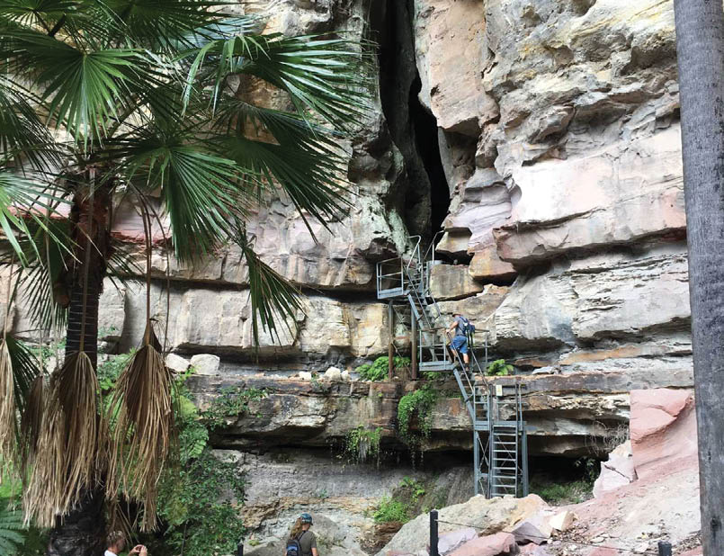
The Amphitheatre walk leads you up a broad side gully to a large cliff wall, which could easily be described as an amphitheatre, but no, keep going. Climb up the ladder and into
the narrow slot canyon until it opens into a large open roof cavern - so worth the side trip.
Wards Canyon is a fantastic side narrow slot mossy canyon. If I had to pick a favorite side trip it would be this one, but it is hard to choose. Enjoy the water cascading through the well shaded and cool canyon.
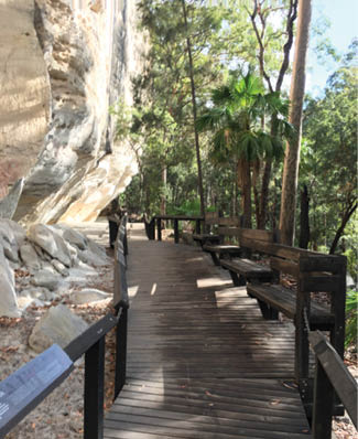
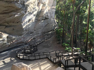
The Art Gallery and the Cathedral Cave are both spectacular natural places in their own right but the clear history of the first nation people is breathtaking. There are boardwalks sensitively built and signs give a richer understanding of the importance of these places.
Art Gallery
Cathedral Cave
8 | BWA October 2021
The walk is short enough that if you start early in the day you have plenty of time to soak up and really explore the side trips. Past Cathedral Cave the track starts to fade and crosses below Boowinda Gorge (tomorrow's turn off) and not long after leads you to the signposted Big Bend walkers' camp.
Big Bend walkers’campsite This delightful campsite is located on the sand banks in the upper reaches of the main canyon. If you only have two days, then the walk here and back is a great way to spend it. I would also be content camping here a few nights. This is a well shaded campsite, surrounded by towering cliffs. There are a couple of pit toilets and a picnic table. Water can be collected from the creek. I spent the evening chatting with a lovely couple at the picnic table and sharing walking adventures, and talking American politics. Beware of the mice, seriously. At 3 am I woke to two of the cutest tiniest mice scurrying around me and my shelter. The persistent creatures were evicted after a good ten minute wrestle and after they had a good nibble at my food. I highly recommend bear bagging your food each night as these things will chew through anything.
Day 2 - Big Bend walkers' camp - Gadds walkers' camp, 14 km, 5.3 - 7 hours After packing up camp we were sharing mice related war stories with fellow campers. Seems there were a lot of mice or a very enthusiastic pair - most tents had a newly installed mouse door.
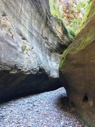
The walk leads back down the canyon a bit before turning right up Boowinda Gorge. I was so unprepared and unfamiliar with the walk that I was surprised and really delighted by this canyon. There is no track. I was walking through the small boulder field that formed the dry creek bed as the tall cliffs came closer and closer. Soon you could
touch each side looking up through the crack to the sky far above. It is slower walking on the rocks but it is a place worth taking the time.
Ohh and then the climb starts. Don’t worry, it is only 600 metres over four kilometres. Oh wait, what?
Yep you feel it, but again, there is no rush. Walking up Boowinda Gorge I noticed a side gully with a small orange triangle on a palm tree, the canyon exit. The track up this gully is steep, so I needed to use my hands and scramble over a few rocks. Nothing technical but fun all the same. At the top of the gully the terrain opens up to a grassy understory of a tall forest. The start of the aptly named Battleship Ridge. This is where the rest of the 500 metre climb happens. Just under an hour after leaving the canyon, the track leads over a rocky scree section, then 30 minutes later I climbed up a short metal ladder/steps.
Big Bend walkers’campsite
Boowinda Gorge


BWA October 2021 | 9

Gadds walkers' camp
Then another 30 minutes later brought me to the intersection with Battleship Spur. Is it just me or did they get the spur and ridge naming backwards, weird. Anyway, I can only assume based on the lack of finding anything else that the Battleship naming is how the person felt when they walked up. But really it is not that bad. Take your time and enjoy the shade of the palms as you walk up looking back at the stunning views.
The side trip to the Battleship Spur Lookout is only 500 metres return from the intersection and proved a great morning tea spot as I glanced back down over the main gorge. If you were able to sleep in a bit more, somehow avoiding the mouse alarm, then this would also be a great lunch spot. Actually almost anywhere on this day is a good spot for lunch.
The rest of the walk to camp took me about three hours. It is mostly undulating through open grassy forest, through a few narrow gullies, along a few rock creek beds, but most open wide flatter lands. I stopped for lunch on a log in one of the more narrow and cooler gullies. The steepness of the morning's climb was forgotten (maybe forgiven) and it is just a lovely meander through what to me is unfamiliar but delightful country.
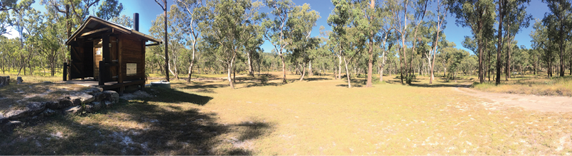
Gadds walkers' camp This is the first of what seems to be “the classic” campsites that define this walk. A large post shelter with a tin roof that feeds two underground water tanks, from which water is obtained by hand pumps. The water tanks are much needed as there is not a lot of surface water for much of the year
on this walk. This campsite also has a well maintained pit toilet and plenty of space to camp.
Time for a wash and hangout for the afternoon. As the sun was getting close to setting and I was sipping my ice tea, I could hear a group approaching in the distance. They were the families from the Northern Territory I briefly met yesterday. What a delightful and fun group. We stayed up into the evening chatting about the day, near misses with mice, and other adventures. Over the next few evenings we became friends. We walked separately but I looked forward to them joining me at camp.
Day 3 - Gadds walkers' camp - West Branch camp, 16.7 km, 5 - 6.5 hours Today’s walk is not about the “in your face'' spectacular that defined the last few days. There are three main parts of the day - walking up along the Angelina Creek valley, then walking up to and along the plateau (part of the Great Dividing Range), then wandering the Boot Creek valley to West Branch.
From the campsite I walked for a short distance before joining the management trail and wandering. You get a feel for how

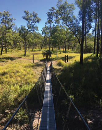
Swing bridge near West Branch campsite
10 | BWA October 2021
the area was once a popular grazing land. There are a series of creek beds to cross but is generally a fairly open pleasant forest. When I came through, the grass was about 1.5 metres high in places along the old trail. Although still pretty easy to follow, the track was faint in places and I did hit a few unexpected bumps I did not see. But no dramas.
Following the spur down off the far end of the plateau, I checked out the view to the basalt capped peak of Mount Moffatt off to the left. As I continued down the valley though the varying forests, I passed a series of signs to cross the (usually dry) west branch of the Maranoa River on a foot swing bridge. On the far side of the bridge is the second (alternate start/end) trackhead for the walk, and the basic West Branch walkers camp.
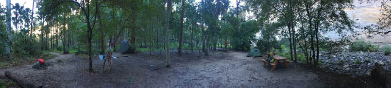
West Branch campsite I walked a few hundred metres further to camp at the bigger 4WD camping area. There were no cars when I got there. A few came later but it was still a pleasant place to camp. Picnic tables, toilet, tap tank water and fire pits. My NT friends came later and had some of their other friends drive in, so there was snack food, drinks and a pleasant evening chatting around the campfire.
The walkers campsite is a flat grassy area with a water tap, no other facilities, but an easy short walk to the toilet if you want to use it. I think if I were there on a long weekend I would have camped here.
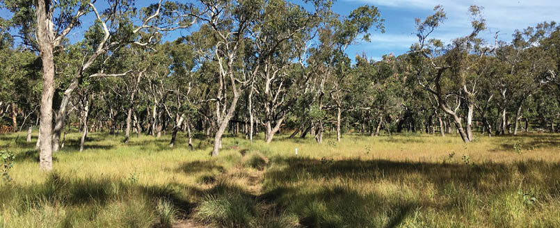
Day 4 - West Branch camp - Consuelo camping zone, 16.1 km, 5.5 - 7.5 hours A relatively easy day and a great change in vegetation. As I kicked off I climbed up onto and followed a ridge through a notably taller
woodland and open forest, a mix of Sydney Blue Gum and more Silvertop Stringybarks, as well as a scattering of the tall Macrozamia cycads. I got to the Mahogany Forest for morning tea. This would be an awesome lunch spot. The "Mahogany" forest is a silvertop stringybark (Eucalyptus laevopinea) growing up to 40 metres high. It is a real change in vegetation from the rest of the walk. It is a pretty easy, mostly downhill walk to the Consuelo camping zone. I got there for lunch and was feeling pretty itchy so I kept walking and got to the Cabbage Tree camping zone comfortably before dark.
Consuelo camping zone Now I did not camp here, but filled up water bottles and had lunch. There are a couple of signs along the track that you can camp between. In the middle is one of these nine post shelters with two pumps and underground water tanks.
Day 5 - Consuelo camping zone - Cabbage Tree camping zone, 13.6 km, 3 - 4.5 hours This is an even easier day, the easiest of the whole trip. The track follows an overgrown old 4WD track through a blue gum, angophora and cycads forest, and a fairly gently undulating track.
Cabbage Tree camping zone This is a camping area, so there are a couple of signs along the track that you can camp between. In the middle is one of these nine post shelters with two pumps and underground water tanks. Most people seem to camp near the shelter. It is up high and exposed to the wind, even though you are in the forest. It was a pleasant evening for me, but I imagine it could get very chilly.
West Branch walkers campsite
BWA October 2021 | 11

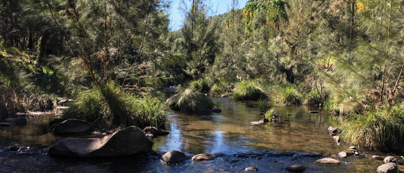
Day 6 - Cabbage Tree camping zone back to the start, 14.5 km, 5 - 6.5 hours The last day was dominated by cliff top views and walking down, down, down hill. I slept in and didn’t leave camp till 9 am. I was feeling pretty lazy and pretty good about it. Within fifteen minutes I passed my first stunning view looking north over Jimmys Shelf. An hour later I was winding down a spur and crossed a fairly large body of water that was not marked on the map. I can’t find notes on it but I assume it is a dam built by the stockman who worked the area. Soon after, the track leads down some steps to cross the cool and gently flowing North Arch Creek. What a great spot to rest on my lazy day.
Three hours after leaving the camp I came to the narrow Demons Ridge where a short informal track leads to the top of a rock platform on the left of the track. Views north seem to go on forever past Arch Chasm. And looking back the track there were glimpses of
The Ogres Thumb rock formation. There are a series of more unfenced and unsignposed cliff top views off to the left as I continued down, hitting touristville again at the intersection with the Boolimba Bluff Lookout track. I dropped my pack and took the basic pack with lunch for the 750 metre wander out to the series of fenced, shaded and special lookouts. The views were down to the start of the walk and across the mouth of the main gorge. A lovely spot. I started chatting with a friendly walker who later turned out to be staying at the same caravan park as me. She and her husband shared dinner with me. I love meeting walkers and hearing their stories, especially when food is also on offer.
The walk then leads steep down a series of steps and ladders into the gorge and back to the Visitors Centre. Yep this counts as a great walk in my book. Not one for the bucket list, but definitely worth the drive and a week. Queensland parks have done well.
Entrance to the Amphitheatre
12 | BWA October 2021

Getting there
Carnarvon Gorge NP sits between Roma and Emerald, about 720 kilometres by road north-west of Brisbane. The road is good with just the last few kilometres on a good dirt road. There are plenty of day and multi-day parking spaces near the (start of the walk).
Where to stay
There is a good range of accommodation options near the start of the walk for before and after. It is a long drive for most people, so staying before and after the walk is a good idea and gives you more time to enjoy the area. There is a national park campsite at the start of the walk (only open during school holidays) and a short drive away you will find a great caravan park and some more fancy hard roof accommodation.
When to walk
The walk is closed from November to the end of February, during the main heat of the year. The time between May and September gives you a good balance of not being too hot or cloudy. See bom.gov.au
Permits
You need to book and get a camping permit for each night, about $7 a person a night, pretty good value I reckon. I would happily pay that just for the water supply. Two people walking for five nights will pay just shy of $70 on campsite bookings for the actual walk. Also, budget for a night or two before and after the walk.
Walking pace
I found that most days you can be at a camp by lunch time if you start early enough and walk at a fair pace. I had some lazy lunches and snack times on rocks with views. You can do the walk at a faster pace. I ended up merging a few days into one. But if you can, take your time. Give yourself the full five nights, explore the area, enjoy the views and curl up with a good book. Also, I had an extra night after the walk in the local caravan park to enjoy some swimming and explore a few more canyons. So give yourself a good week. Yes, you can do it quicker. If you're fit and happy to move you could complete the walk in three nights easily enough.
Water access
There is water at the start, end, and at each campsite. All water is pro-moted as needing treating. At the first night’s campsite, water is from the creek. The rest of the walk has water tanks.
Fires and stoves
This is a fuel stove only walk. All the walkers' campsites have a no campfire rule. The one exception to this is the West Branch camp (the car camping area, not the walkers camp) that allows fires in the pits provided. All the campsites have clearly regularly used fire scars, but avoid the temptation.
Typical woodland when walking along ridge tops
BWA October 2021 | 13
Access points
Most people start the walk at the Visitors Centre, the main entrance to Carnarvon Gorge. There is also a secondary track head at West Branch, which requires a 4WD with high clearance and a much longer drive. West Branch might be a good option for people wanting to resupply or if you only want to walk part of the route.
Communication
Very limited, Telstra (not Telstra wholesale like Aldi). There is GPS coverage for the whole trip other than in the short very narrow canyon sections.
Group size
Campsites are limited to groups of six people and you can stay up to two nights in each of the campsites.
Direction of travel
The walk is promoted for people to travel clockwise and this worked well for me. I think the anticlockwise would work fine too if you had a good reason to do it, but otherwise I think stick with the trend here.
Track grade and navigation
The walk is correctly graded as a class 5/6 as some sections the track are faint and unclear. Most intersections are tastefully and clearly signposted and the map is generally accurate (a few minor issues). I was a bit surprised that a fair amount of the second half of the walk follows an old 4WD track, but is pretty overgrown, so it did not feel like a road slog. You don’t need to be a super-experienced navigator, but you will need to be comfortable navigating using a topographic map and dealing with ambiguity in places. The track is also marked with small metal orange (clockwise) or red (for anticlockwise) markers on trees.
Track surface
The track surface varies greatly over the walk. The main thing to be prepared for is walking on small boulders. Most of the sections you will be walking on firm, but sometimes loose boulders, a potential ankle nightmare. Most of the walk is on naturally compacted sandy soils with natural gravel. Some sandy sections. I walked in runners and that was fine for me.
Swimming
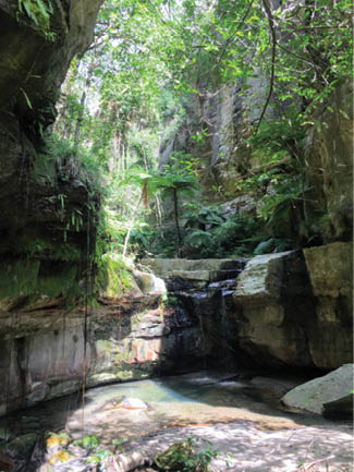
There are very limited opportunities to swim in the national park. There is only one designated swimming area in the park called “Rock Pool”, which is well worth the visit before or after the walk. Other than the main gorge, the rest of the creeks don’t hold reliable water for much of the year. Swimming in the gorge is not allowed for both cultural and environmental (think platypus) reasons. This is the one thing I wish I knew before setting off for the walk. I love my swims on walks. It is not a big deal, I just found it a bit disappointing because of my lack of research beforehand.
Rock Pool
14 | BWA October 2021

What else to do in the area?I was actually pretty keen to chuck gear in the car and just go, but I heard there were a few more short walks in the area and figured I should do them all. So I stayed at the caravan park, had a great time meeting other walkers and people planning on hitting the track the next day, but oops, I think I freaked out one person about the mice.
The Nature Trail is a nice walk, but not worth travelling for. The short walk to Rock Pool was great, and just past the first pool is a more pleasant area to swim - a refreshing waterhole but great.
Mickey Creek, yep do it. This is a drive back from the main visitor area. The main track is good and leads up to Mickey Gorge, a pleasant creek. But part way up is a signposted side trip up Warrumbah Creek Gorge. Do this one too, this is where the magic happens. Warrumbah Creek Gorge is a narrow canyon with no formal track once in the canyon, so just go as far as you can safely do so. it is a narrow slot canyon winding up through the valley with a series of short waterfalls and waterholes.
Read more here
To get a sense of the size of Amphitheatre, look for two people in the photo


BWA October 2021 | 15