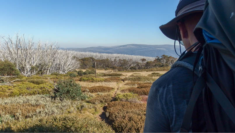
AAWT Omeo Highway to Mount Hotham
Text and photosNick Bean
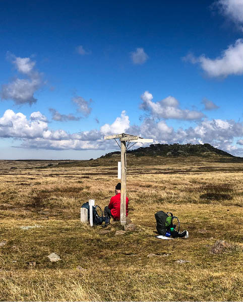
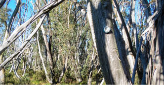
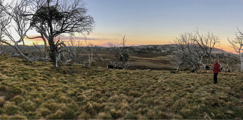
Pole 333 and Mount Jim
The conceptEaster, 2021
After completing other sections of the AAWT in multi-day walks, namely, Rumpff Saddle to Mount Howitt (five days), then Mount Howitt to Mount Hotham (six days), this one seemed a natural to do. How hard could it be - after all, we did The Crosscut Saw and the Dry Barrys in April, easy ... perhaps.
A night at Mount Hotham, a good meal at the pub and we were ready to walk. Leaving my car near The General at Hotham, we headed off with friends towards Omeo. While it was an easy drive, the bit from Omeo to Glen Wills was a little windy, to say the least. Not good for those of us that suffer car sickness. Well, the good news is, I kept breakfast down and we unloaded the car at the AAWT leading to Mount Wills. The adventure begins.


12 | Bushwalk April 2023
Mount Wills Hut Stephen Lake

Follow the yellow triangle. Otherwise, look for flagging tape. Otherwise, look for tracks people have made. Or, based on the map, take a punt and walk. It works out in the end.
Day 1: Omeo Highway to Big River Saddle, 10.4 kmStarting elevation 1200 metresMaximum elevation 1757 metresEnd elevation ~1200 metres
The first 2-2.5 kilometres is an easy ramble along an old 4WD track, but you reach a point where the climbing starts. From the 2.5 kilometre mark, it's up until you reach the Mount Wills South area where it levels out a little. Time to regain a bit of breath before heading up to Mount Wills proper. Bear in mind, we had seven days of supplies on my back (well, breakfast and dinners, and Carolyn had the lunches and the Trangia cooker). Track wise it was quite clear, with just a few fallen trees to step over.
The track from Mount Wills South to Mount Wills seemed to go on f..o..r..e..v..e..r. But, as we approached the top, we started to see the views around us. And what a beaut view it was, along with large slabs of rock to rest on.
At the top was Mount Wills Hut with two bunk rooms, a pot belly stove and a general area, plus running water from the tank outside. Luxury! After a brief stop, we headed NNE down the 4WD Mount Wills Track. A gentle decline made the walk easy. It was all downhill from here to the campsite for the night at Big River Saddle.
Roughly two kilometres down Mount Wills Track a yellow marker indicated a left turn, to the west. The footpad was fairly clear, and a few yellow markers gave a clue that this is the way down. For the next two kilometres we followed an ever steepening track, with the main issue being the track having lengths of bark, which proved to be very slippery. But we survived.
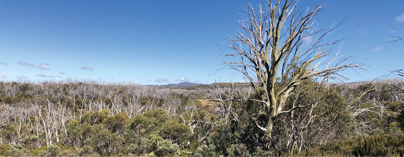
As we approached the bottom half of the walk, tall eucalyptus trees become the dominant species. The last few 100 metres
"
The track from Mount Wills South to Mount Wills seemed to go on f..o..r..e..v..e..r.


13
had a fair amount of blackberries crowding the track and surrounds. This would be an ongoing theme for the next day. A road soon appeared, indicating the campsite area.
A lone trail bike rider zoomed past as I waited next to Big River Road for Carolyn. Other than that we had no company, which surprised me, as the road is in good condition (2WD really), it's Easter, and the road joins the Omeo Highway probably 5-6 kilometres away. But I'm happy for the lack of company tonight. Just Carolyn and myself, in a beaut bush environment. Perfect.
There's a clearing on a bend in the road. In the picture below the road is 20-25 metres to the right of the tent. John Chapman's book mentions water 500 metres on Big River Road towards the highway. While it is flowing well, it's almost impossible to reach because of the blackberries. Plus, the route down
(roughly 1.2-1.5 metres) is extremely challenging. Another source, about 180 metres in the opposite direction, is Mount Wills Creek, which flows across Big River Road. A short hike up from the campsite led us to this source. Get water from the uphill side, on the right hand side. It was flowing well.
The call of the wild. While we have seen Alpine Dingoes on our walks, we haven't heard them before. A rather mournful call. Lonely in some respects.
Big River Saddle

"
While it is flowing well, it's almost impossible to reach because of the blackberries.
14 | Bushwalk April 2023
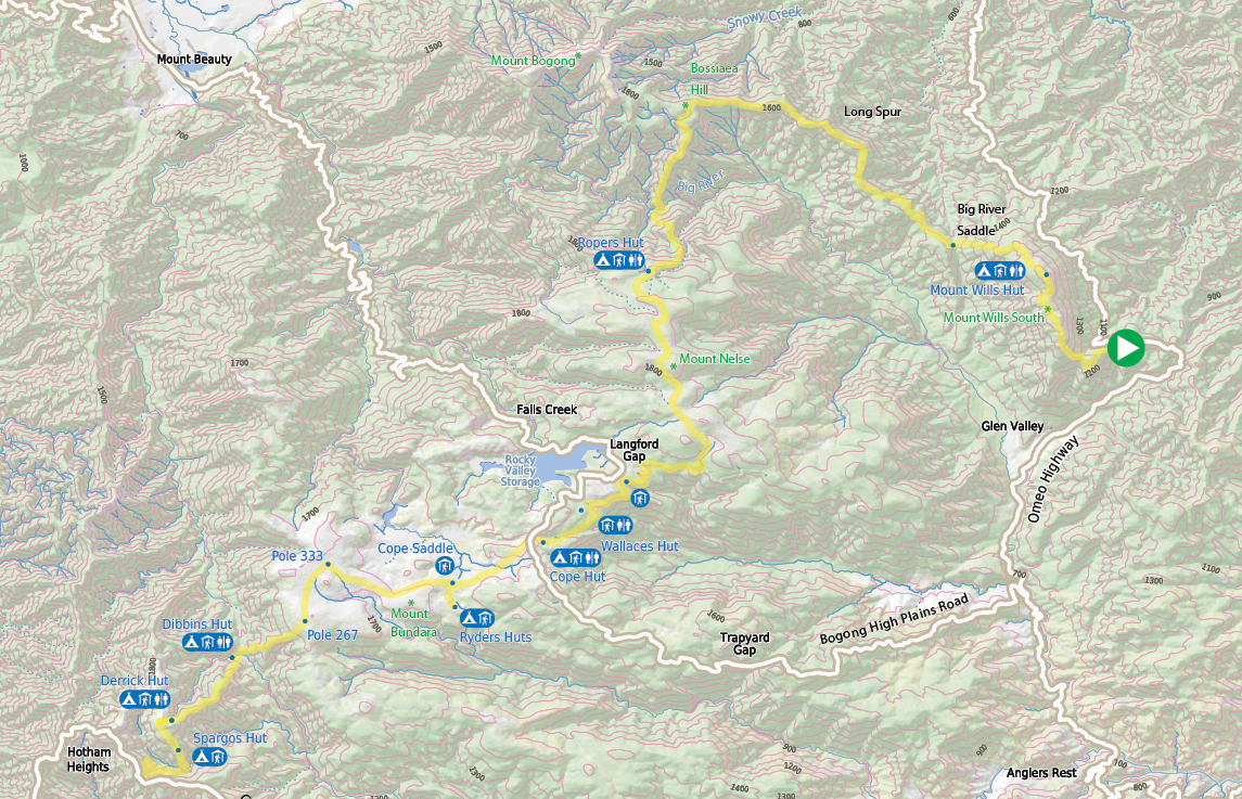


Bushwalk.com notes and maps on webpage, GPX and PDF
This map is © Bushwalk.com and is created using data © OpenStreetMapcontributors
Road, four-wheel drive track, walking track (treed)
Main track, side trip, alternate route
Cliff, major contour line, minor contour line (100 metre interval)
Lake, river, waterfall or creek


Omeo Highway to Mount Hotham


0 5 10 km


Start of the walk
Hut
Campsite
Toilet
Shelter


15
Day 2: Big River Saddle to Maddisons Hut Site, 14.7 kmStarting elevation 1200 metresMaximum elevation 1775 metresEnd elevation ~1700 metres
After a beaut meal and a good night's sleep, the pain of climbing Mount Wills was forgotten. I mean, it was only 10.4 kilometres. Yeah, a bit of a slog going up, but remember, going up a hill means going down a hill.
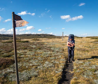
Long Spur was our challenge today. For nearly half of this walk, it's 2WD or 4WD tracks in various stages of disrepair. The first few hours really just involve following a vehicle track. So, auto pilot on and take in the views. There's a bit of up and down, mostly up, but nothing too dramatic. The end of the 4WD section was marked by a wooden picnic table and a sign "The Long Spur", a good place for an early lunch.
There are two picnic tables in the next kilometre or so. The first was probably dropped off by 4WD, and the second a
few hundred metres further was perhaps disassembled and carried. The third is a fair distance to travel with a disassembled wooden table. Impressive!
After lunch, we headed off for the final 6 kilometres to Maddisons Hut Site. It was a mixed bag, walking wise. Once again the walk trended up and down, with up being the dominant aspect. Blackberries appeared along sections of the track, with dense scrub making it hard work.
At one point a couple of kilometres from the picnic tables, we descended into a saddle, which gave us a breather. Climbing out of the saddle, we could see the last long climb of the day, Bossiaea Hill. As we started the climb, we had clear views of Long Spur and Mount
View towards Maddisons from Bossiaea Hill

"
It was a mixed bag, walking wise.

16 | Bushwalk April 2023
Wills in the distance. When walking for a few days it always strikes me that the path you have travelled can be seen fading off into the distance. And this was only day two!
Bossiaea Hill is a fairly moderate climb. The views make it worthwhile. The track curves around to the left, never really reaching the top, but traversing around. Once we slipped around Bossiaea Hill, the final downhill section appeared, along with snow poles, which will be with us all the way to Mount Hotham. As we wandered down the open plain, a creek on our left became apparent. Ultimately, this is our water source at the campsite. About 500 metres before the campsite we noticed a couple of patches where feral horses or deer had wallowed and muddied up the creek.
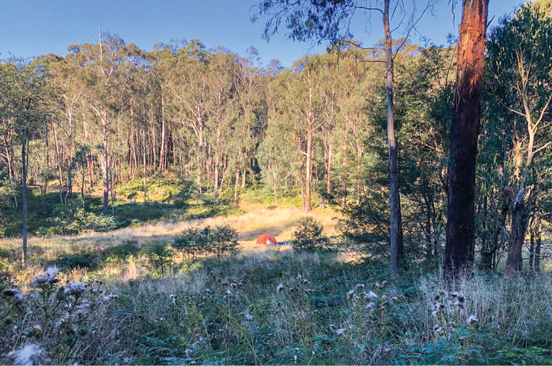
Maddisons Hut site is a little cosy if you have more than two tents. A couple had already set up camp at the site, and when we scouted
around, we found another spot 100 metres along the track, towards Cleve Cole. In the end, while happy to be social, we moved to this new location. In the photo above, the walking track is only 5-7 metres below the tent. But we didn't expect too many others. A few groups came in late, but most were heading to Cleve Cole Hut, two kilometres away.
One thing about clear weather conditions is the ability to just unpack stuff where and when you feel like it. This is completely different when it's raining, and you're frantically trying to keep everything dry … you have to think strategically, how to pack things, then unpacked, to minimise getting wet.
Long Spur is a bit of a slog, but it's not hard and the views are great.
Camp near Maddisons Hut site

17
Day 3: Maddisons Hut site to Ropers Hut, 8.4 km Starting elevation 1700 metresMinimum elevation 1050 metres - yes, a long way down End elevation ~1700 metres
Day three - the big one. I've hiked for over 30 years but not yet done Big River, so it was weighing on my mind. The first 1.6 kilometres of the walk was easy, a nice stroll in the Snow Gums. We started to head down the ridge, fairly clear walking. In the far distance the Bogong High Plains beckon. In the immediate distance, the top of the ridge still shows, with a gentle saddle to wander. The views of Mount Wills were inspiring. We were there, days ago, but that's one heck of a valley dividing us and the Bogong High Plains. Hmm …
Meanwhile, I noted a number of the track markers were made from old (beer?) cans and nailed up. If it saves carrying them out …
By now, the Snow Gums have given way to a taller forest, indicating our drop into a lower altitude. Now, the walk headed down more steeply, zig zagging some of the way, and in other parts it's just straight down. Careful foot placement becomes paramount. And time seems to drag on, with the tops of tall trees still appearing below. The sound of the running river starts to be heard.
The forest canopy became dense, but the track was wide and clear. I noted on the way down that someone had been here in the past couple of weeks with a chainsaw. Freshly cut fallen trees. Sawdust across the track. An impressive hike in with such gear, I thought.
The last 100 metres are flat and take you past an area that one could pitch a tent. But it would be crowded. Looking across the river, flowing with reasonable vigour, I see lots of one metre sticks on both sides of the crossing. A sharing scheme appears to be in place, with people using, then leaving on the opposite bank.
Carolyn, being the lover of water (and a white water kayaker), quickly pointed out a path though the knee-deep water, as it bubbled past. Parts of the river looked challenging. But, we are here now!
Quickly shedding my shoes, socks and pants, I tucked them and my phone into a waterproof storage bag, attached it to my pack and put on my rubber kayaking shoes - they have superb grip in these crossings. And away I went. As expected, the water was cold, and with the help of two sticks, I managed to make it across without any drama. Close behind was Carolyn. I was hoping to get footage of the crossing, but it was not to be, maybe next time. Note: the chain which would normally assist with the crossing was broken. You can see it in the picture (on the next page) wrapped around the log on the right.
After the half hour of mucking around in the water, it was back to the serious bit, getting up Duane Spur. In some respects, I'm a "give me a hard, steep climb, but lets get it over" type walker. Duane Spur isn't really like that, unfortunately! It goes hard for two thirds of the way then dips down, then just wanders on f..o..r..e..v..e..r, or, at least it seems like that. The last kilometre is tantalising, as we meander through snow gums, bushy bits that open up, then close up again.
In my spare time, between breaths, I noticed a wombat burrow on the side of the track. Active, from the looks of the diggings. Looking back across the valley, T Spur loomed large. That's one big lump to walk, up or down, but we had done it.
We noticed the toilet first, then Ropers Hut, further away – finally arriving at about 4 pm. There were two other pairs camping in the area, both gathered around a tent. Without even putting down packs, we joined in the conversation. One couple had been here for
Beer can as a marker on the track

18 | Bushwalk April 2023
a couple of days, the other couple, Adam and Bec, were doing the entire AAWT from south to north. This was day 35 for them, but they had started from Federation Square and, on foot, spent five days trekking to the start of the walk! They were planning to take sixtyish days for the trek. Why rush - enjoy.
Day 4: Ropers Hut to Ryders Huts, 25.6 kmAnd yep, a slog.
Starting elevation 1710 metresMaximum elevation 1860 metresEnd elevation ~1660 metres
Today was regarded as an "easy day", walking the relative flats after three days of hills and mountains. And in some respects, it was easy. All of the tracks in this section are either gravel roads or well worn walking paths. So, set the auto pilot on, brain off, as far as real navigation goes, and enjoy the scenery with beaut sunny conditions.
Leaving Ropers we had a last visit to the water source, Duane Creek, with its small gushing waterfall, and ice cold water. Such
a treat. A gentle climb saw us heading past the intersection with Timms Spur. Behind us, Mount Bogong loomed in the background.
With Mount Nelse North and Mount Nelse on our left we dropped packs, with the intention of "climbing" Mount Nelse North. Heading towards the summit, we realise it's a distance away and return to our walk. While certainly an easy one, we did have mileage to do today.
The landscape up on the Bogong High Plains is broad and flat. It's big in size, not height. Nearly six kilometres from Ropers we were near two other huts, Johnstons Hut to the east and Edmondsons Hut to the west, each 10-15 minutes from the main pole line. Twelve years ago, I stayed at Johnstons Hut. A nice location.
Between Marum Point Track and Langford East aqueduct we walked through a treed section, with views of Mount Cope, beckoning in the distance mid frame. Our plan today is to skirt around to the right of the peak, then head to Ryders Huts. At this stage we were shy of halfway. As I said earlier, it's a big place to walk. Distance is the key word.
Big River


19
From the AAWT, between Marum Point Track and Langford East Aqueduct, the view of the Rocky Valley Dam peeks through the rolling hills. From Langford Gap to the turn off to Cope Hut, it's just a flat walk beside the aqueduct or pipe. Back to auto-pilot mode, enjoy the views, enjoy the bird life.
A short distance before Cope Hut we had an option to head up to Wallaces Hut and following the pole line to Cope Hut, between the aqueduct and the road. But, since I was
going off John Chapman's book, I didn't have any details about this section, so continued as per the book. I was aware of the option, but, I thought we might as well keep going. Ah, Cope Hut. A little busy, a little crowded for our liking (remember, this was Easter).
Crossing the sealed Bogong High Plains Road, we were on the final stretch to Cope Saddle and Ryders Huts. Just follow the pole line and a foot track that had matting for long sections.
Marum Point Track with Mount Cope on the skyline
Mount Cope sign
In fog this section was confusing. We saw an old sign stating "Mount Cope ½ mile", probably dating back to the 1960s. At this point, there's what appears to be an old 4WD track from the Bogong High Plains Road, which merges into the AAWT. Both tracks, 4WD and Mount Cope summit, show on the map and GPS.
Ryders Huts area. No one around. Tranquil. While we could see the huts from Cope Saddle, as a shiny structure, the map and GPS showed different tracks to get there. It's easy, once you know how. While we could have stayed at Cope Saddle, it was far more scenic to walk the two kilometres or so. Also, camping at Ryders Huts is more sheltered. It's a flat walk, so just slip into auto mode and enjoy.
20 | Bushwalk April 2023
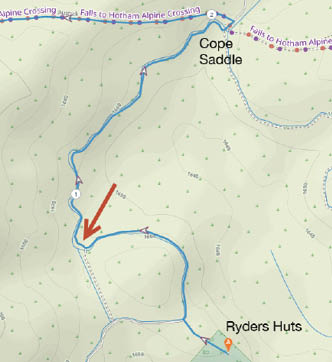
What's not obvious when finding Ryders Huts is the left turn, where an old aqueduct heads east, the red arrow on the map . This wasn't on the map I had or on the GPS. However, it is on the online map supplied by Plotaroute, which is how I can show you, after the event. I had a gut feeling that we turned left, so we went that way, and completed the loop before realising that we had gone past the hut. Water was another issue, as the only place to fill up is from the aqueduct. This was the only place in the six days that we filtered the water. While it was flowing, we felt more comfortable in filtering and treating the water with UV. I'm not a fan of the tablets; the magic UV wand has been fine.
Day 5: Ryders Huts to Dibbins Hut, 12.1 kmStarting elevation 1660 metresMaximum elevation 1784 metresEnd elevation 1351 metres
Today really was an easy day. Only 12 kilometres or so, with a stretch downhill. It was a quiet night with no sounds to alarm us, but I had a very wet tent from condensation. Inside also suffered from the drips. My brand new Mont sleeping bag became a little damp near the feet area! But, inside the bag, toasty warm.
Today's walk involved a big loop around Mount Jim then a drop down to Dibbins Hut near Cobungra Gap. After the past four days of pushing it, with much lighter packs, since we've eaten most of the food, today was a day to enjoy.
The red arrow marking the turn to Ryders Huts
Ryders Huts camp area
21
From a tent perspective, the Ryders campsite was probably one of the best we had for this trip. It was flat, so there was no sliding down the tent at night. It was like a mowed lawn and there were no ants. It was also the first night we had with frost.
Cope Saddle is to the left of the image below, probably 500 metres away, as we start to climb the back of Mount Bundara.
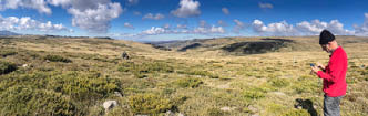
Now, for such a remote area, communications by phone (mostly 4G) is excellent from Ropers Hut to the western edges of the High Plains. Towers on Mount McKay near Falls Creek and on Mount Hotham mean you are always accessible … good or bad. I had a family Zoom meeting to make at 11 am. All I had to do was find a reasonable boulder and participate!
At the intersection of the AAWT and Tawonga Huts track, pole 333, we were roughly halfway through our walking day. We had plenty of time and just stopping to look at creeks, wildflowers and the scenery was wonderful. Great weather to top it off.
Now I had been at this intersection back in the 1990s. One summer a friend and I hiked from Hotham to Falls Creek and back, via Westons Hut. From memory it was a hard slog up Basalt Temple. The good 'ol days.
It was along this stretch, between the intersection and the SEC Hut track that we saw our first feral horses. I'd never really seen them before. Initially we could see them way off in the distance. But, as we rounded some of the gentle hills, we would see more. We probably counted 30-40 in groups of 6-10 horses. As much as I don't want them in the High Plains, there is a certain magnificence about them. We also saw two horse riders off in the distance, heading east, maybe in the direction of Ryders Huts.
Looking back towards Mount Cope


Zoom meeting on the High Plains

22 | Bushwalk April 2023
Nick is from Melbourne and has spent most of his working life in IT. He has been bushwalking for 40 years, trekking in mountainous parts of Australia, Chile and Argentina. Of late he has gone on multiday walks, such as the AAWT. A passion in photography has meant there are times when camera gear almost outweighs essential items. Carolyn is from Manjimup, Western Australia, and has spent her working life nursing. Between nursing stints, she travelled, walked and cycled around the globe. Most memorable are cycling large parts of Australia, Tasmania and England, trekking in Nepal, and six months in Africa.
"
At the intersection of the AAWT and the SEC Hut track, pole 267, we had a break, ready for the final trek down. As we waited, a group came up from Basalt Temple. They were doing a day walk from Hotham to Falls Creek. A great day for such a trip.
The initial two kilometres is easy, a wide, gentle slope that soon narrows to a ridge, which then drops steeply. Just before the drop, the views of Hotham and Feathertop are stunning. The Dibbins campsite is split between the tent platforms and the hut area, with a few tent sites in between. Call me old fashioned, but I prefer the site next to the hut. For starters, it has the table to use for meal preparations. And we are upstream from the other sites.
Day 6: Dibbins Hut to Mount Hotham,8.8 km Starting elevation 1351 metresMaximum elevation 1782 metresEnd elevation 1680 metres
With the car parked down near the pub (The General), we made a detour at about the four kilometre mark. We could have headed to Mount Loch carpark, then walk the remaining distance along the road. Or, plan B, turn left and head down the Huts Track, past Spargos Hut, down to Swindlers Creek and up to the road. We took plan B.
We had time today, so, we meandered up to the four kilometre mark, looking at the bugs, flowers, etc. At the top we took a left turn on the Huts Walk, towards Spargos Hut. Once again, looking back to the east, we could pick out mountains and plains that we had wandered through, just days ago. Soon we were looking down on Spargos Hut. Just a bit more down, then a bit more up, and we have finished.
The section up from Swindlers Creek is a bit of a push. Besides nearly standing on a Copperhead snake, we were running a bit behind schedule. The drama there is, the pub would stop serving meals! But, we made it.
SummaryOverall, this is a great walk. Thanks to our friend Rob and his son Matt, who dropped us off at the start. While some of the days had us walking 20+ kilometres we never felt pushed by it. Navigation was mostly with map and compass, with GPS only being used on the first day when climbing Mount Wills to clarify a right turn we had to make, at the start of the climb. After that, it was mostly 4WD or well worn tracks.
Piece by piece, section by section, we wander the AAWT. Hopefully in two years or so, we will do the whole thing.

23