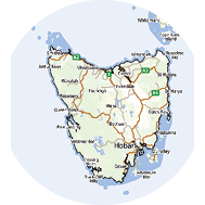
South West Cape Range Circuit
Text and photosBill Bennett
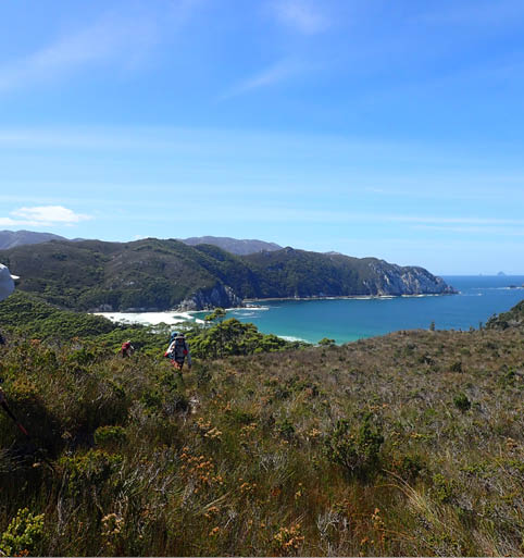
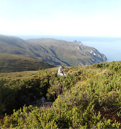
Day 2 - Hidden Bay en route to Ketchum Bay
We walked the South West Cape route in a clockwise direction over seven days in late February 2023, following Chapman and some notes from Bushwalk.com forum, including tasadam (2009), Mechanic-Al (2017), and particularly rwildman (2020), which were all very helpful. It also really helped that we had stunning weather. A lot of what I’ve written duplicates other trip reports but I’ve added some observations that might help others in future.


20 | Bushwalk August 2023
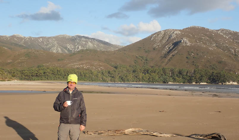
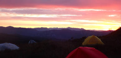
Day 1 - The author enjoying a whisky in the evening sunlight at New Harbour
Overall, the tracks are pretty well-defined now, I think they have been well-walked since Chapman’s day. We probably lost the track two or three times every day once we left Wilson Bight, particularly in forests. But a bit of casting around usually found a marker tape, or spotted the pad in the distance. It helped enormously that we had excellent weather going over the South West Cape Range. It would have been more difficult in misty conditions, and definitely heeded rwildman’s sage advice that the track goes straight over “Every *&%$#! Summit rather than sensibly contouring around.”
One of our crew really started to slow down on the second day, and was very slow on the uphills for the next four days. This meant that travel times were much slower than Chapman, and probably slower than most parties considering doing this walk. We had lots of stops. Nevertheless, we made it! Our friend was actually unwell – he wasn’t hungry, the food made him faintly nauseous and he had little energy, possibly rotavirus.
Day 1: Melaleuca to New Harbour, 12 km, 5 hoursThis was a day on a fast good track from the airstrip to the lovely New Harbour beach. The track pops you out at a lagoon and there’s a campsite just south of that with good water. It’s quite sheltered but very mossie-ridden, though, so we walked to the larger campsite at the other end. Water in the creek was okay when we were there, but there had been rain the day before.
Day 2: New Harbour to Wilson Bight, 13 km, 10 hours We originally planned to split this over two days, but our flight was delayed by a day due to weather, so we made up the time. This was a surprisingly long day, taking almost ten hours, although we had some leisurely lunch stops. The track is easy to follow, but crossing the Amy Range from Ketchum to Wilson Bight is pretty overgrown and was hard work pushing through the scrub at the top. Also, make sure you follow the track at the back of the campsite which heads south from
21
Ketchum Bay, not the older track at the north end of that campsite. Also note that you want to hit Wilson Bight near low tide, to get around that fin of rock in the middle of the beach. There is a small campsite at the east end if you need to wait for the swell to die down.
We camped on the beach at the west end of Wilson Bight GR 256788, beyond the rocky fin. There is a creek with good water coming down here. There are sheltered campsites tucked behind the dunes both east and west of this creek. The campsite is marked on the 1:50,000 map, the creek is not.
Up to this point, the track is very clear and is marked on the map (we used the digital 2021 South Coast Walks map). After Wilson Bight, the track is not marked, and some navigational skills and track finding will be required. If you absolutely hated pushing through the scrub at the top of the Amy range, then the full circuit will definitely test you to your limits.
All the beaches along this section have good campsites and are absolutely stunning. Any one of these is worth walking there and back from Melaleuca if time, weather, or inclination deters you from doing the full circuit.
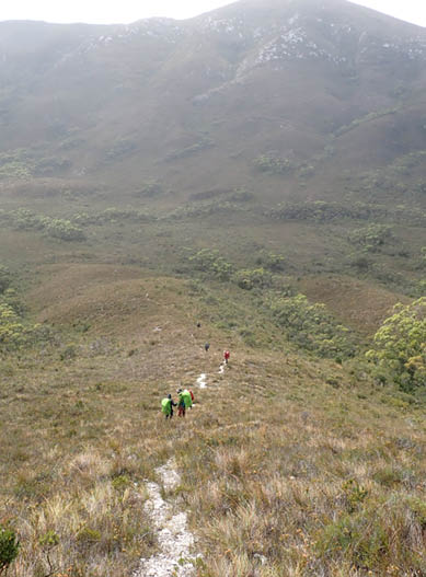
Day 3: Wilson Bight to the South West Cape Range, 6.5 km, 8 hoursAs we were moving slower than expected, we bypassed Mount Karamu and took the shortcut straight up onto the South West Cape Range. The track is well-defined and goes straight up the hill from the back of the campsite on the east side of the creek (we could see another track on the west side that looks okay as well). Steep, sustained scrubby climbing (with amazing views) got us up to the 600 metre knoll at GR 247824 on the South West Cape Range, but it took us five hours to get up there. Realising that we were unlikely to get to Window Pane Bay the same day, and with the benefit of excellent weather, we loaded up on water and mentally prepared to camp high.

"
Steep, sustained scrubby climbing (with amazing views) got us up to the 600 metre knoll ...


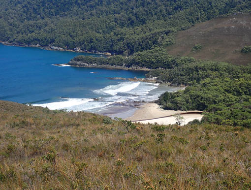
Day 2 - Ketchum Bay
Day 2 - Wilson Bight approaching the rock fin
22 | Bushwalk August 2023

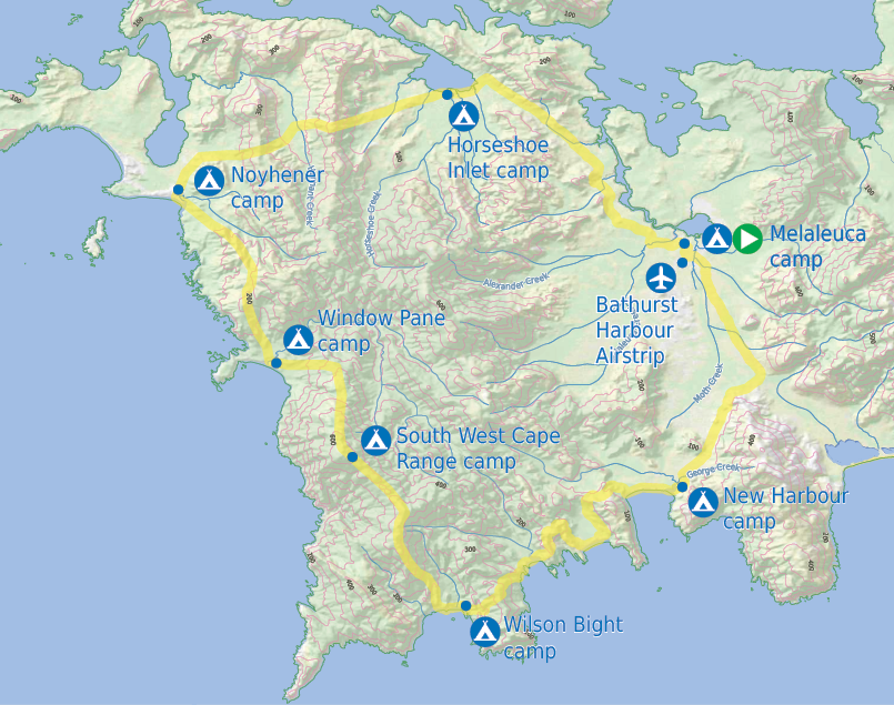
This map is © Bushwalk.com and is created using data © OpenStreetMap contributors
South West Cape Range Circuit
Road, four-wheel drive track, walking track (treed)
Main track, side trip, alternative route
Cliff, major contour line, minor contour line (100 metre interval)
Lake, river, waterfall or creek


0 km 5 10 20 km
Start of the walk
Camp
Airstrip


23
NB Chapman talks about tarns at the main summit with exposed camping. We found this tarn to be very meagre indeed. There was a much deeper and larger tarn shortly after the first knoll at GR 247824. There were lots of frogs and tadpoles and greenery, so we treated our water.
We carried on along the ridge, but we just ran out of oomph and called it at 4 pm after eight hours walking, camping in a saddle just below the climb up the main summit, GR 238836. We pitched tents on grass and low scrub, and with little wind it was a very pleasant campsite – lovely sunset to the west and a stunning dawn over the eastern mountains – Arthurs, PB, Ironbounds, South Coast all laid out for us.
Please also note – we had very calm wind conditions. The prevailing westerlies on the South West Cape Range are fierce and give this area an absolute thumping on a regular basis. This would have made this campsite pretty sketchy – it was difficult to get solid pegs into the ground under the grass and low scrub.

"
We carried on along the ridge, but we just ran out of oomph ...


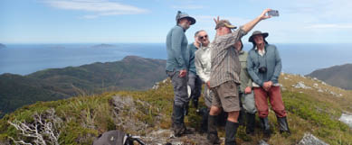
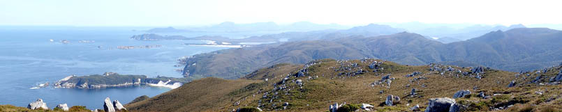
Day 3 - Group shot on the the South West Cape Range, looking south
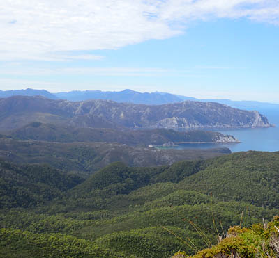
Day 3 - East from high on the South West Cape Range, with the New Harbour Range and Ironbounds in the distance

Day 3 - Campsite high on the South West Cape Range
Day 3 - A tarn high on the South West Cape Range, with a frog population
Day 3 - High on the South West Cape Range with New Harbour Range and Maatsuyker Island in the distance
24 | Bushwalk August 2023
Day 4: South West Cape Range to Window Pane Bay, 5 km, 7 hoursUp early and took us a solid two hours to climb the final bit to the summit – overhead scrub and our friend still badly slowed down by illness. But what a summit view!! The main summit plateau is only about 100 metres wide, and we all looked back as we crested it going “shame to be leaving those views behind”. Then we walked 100 metres to the northern end and went “holy crap!”. We stayed there for an hour just soaking in the coast, the beaches, Port Davey and Bathurst, it was stunning. I recognise that there are probably people reading this who may have stood on the exact same spot and seen
bugger all, as the weather is notoriously fickle. But if you get there on a good day, I would say it may well be the best summit view I have ever had in Tasmania.
Descent from the summit took us a long time – temperatures probably hit 30 °C, and we were all feeling it. Our friend collapsed on the track, and we were really worried. But we got some hydralite into him and carried his pack down the hill for about a kilometre and into the blessed shade of the forest. Just after you enter the forest, you drop down steeply into a gully that crosses a creek at approximately GR 231335. This was about 10 degrees cooler than the scorching air outside and the water
Day 4 - Window Pane Bay, ultra-white rocks
Day 4 - Dawn at high camp at 600 metres
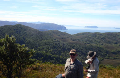
Day 4 - The sublime view north from the South West Cape Range high point

Day 4 - South from a high point with the South West Cape just visible in the distance
25
was icy cold and delicious - an absolute lifesaver!! Our friend rallied magnificently, shouldered his pack and we carried on to Window Pane along a fairly well-marked forest track. Pink tape was there when we needed it. We reached Window Pane Bay at 5 pm after a nine hour day and had a lovely swim. Window Pane Bay is absolutely stunning (again, with the caveat that it faces south-west into the prevailing winds). There is a sheltered campsite tucked into the trees round by the creek, but we camped on the beach as it was very calm and clear. I was lying in my tent with the door open looking out at the Milky Way when I saw a large quoll slinking along the beach and heading to the tents to check them out! It was a pretty special moment, but make sure your food is secured.
Day 5: Window Pane to Noyhener, 7.5 km, 7 hoursThe staked track wasn’t hard to follow, except when we crossed a creek in the forest. Just after you climb very steeply up from the creek, the old track carries on straight ahead and is very obvious. It has some crossed sticks on it
which some of us completely failed to notice. The new track turns sharp right here and is marked with tape and a bottle. Go that way. If you run out of tape, you’re on the wrong track.
When we got to Faults Bay, we followed what was probably Chapman’s original track and then it petered out before we got down to the rocks. We backtracked and found a much better track winding through the forest, marked with pink tape and lots of sawed branches. Follow this, and just keep looking for the tape. This led us down to Noyhener without any drama. This was fortunate, as it was high tide when we arrived. When we looked back along the coast where Chapman advises “just hop along the rocks for 500 m”, it was abundantly clear that this would have been impossible at high tide.
Interestingly, there’s a study of wave erosion on south-west beaches and Noyhener and Window Pane receive some of the highest wave energy of any beaches in the Southern hemisphere. Hence the enormous sand dunes.
Day 5 - Climbing the ladder to the campsite at Noyhener beach
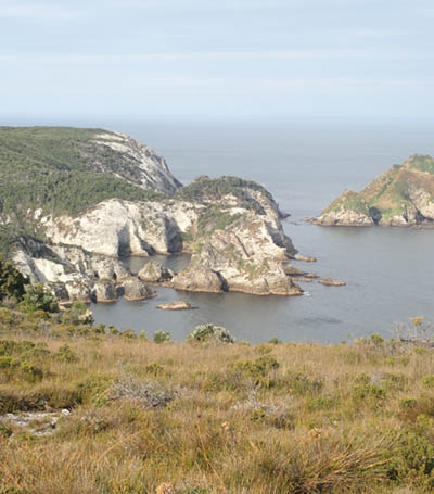
Day 5 - Island Bay, just north of Window Pane Bay


26 | Bushwalk August 2023
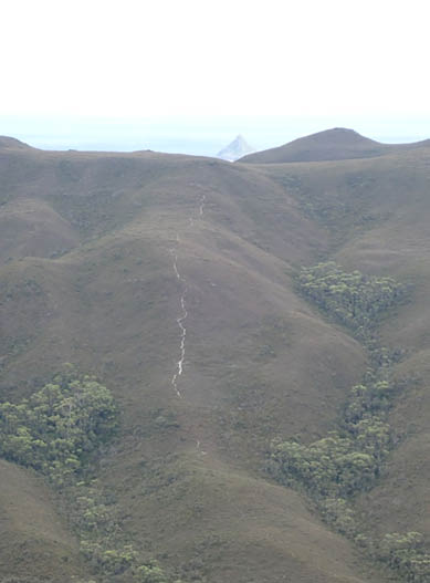
Day 6: Noyhener to Horseshoe Inlet, 10 km, 8 hoursRain had set in, so we set our alarms for an early start – awoke to the sound of the clocks ringing on Pink Floyd's Time, and broke camp in the drizzle. We had some poor weather today, but visibility was okay. The start of the track is clearly marked with buoys and is a well-defined pad. This heads north in a very clear way after about a kilometre, but it’s a trap! As you pass the scrub-filled gully on your right, you can clearly see a track a few hundred metres away heading east towards the South West Cape Range. The track you are on continues north, but you need to turn off down that gully and bash across. There are two white stones on the ground marking the turnoff, but the pad is very unclear in the initial scrub. Just keep heading towards that visible track. The map diagram on the right shows our GPS track.
A is the turnoff you should take;
B is the point where you realise you are on a track heading north and should turn around;
C is the short scrub bash, and
D is the clear track you want to be on.
See also rwildman’s excellent description of this trap. The GPS reference for the turnoff is -43.4009,146.0020.
Day 6 - East to the South West Cape Range
Day 6 - West from the Pasco Range, with the obvious track over the South West Cape Range and East Pyramid Island in the distance

A
B
C
D
27
After that there’s a clear track all the way across the South West Cape and Pasco Ranges, with good water at Hannant Creek. We copped a bit of a thumping from the westerly wind and rain, but the pad is well-trodden and we were sheltered once we crossed over to the lee side of the ranges. There was little bit of uncertainty descending off the South West Cape Range just where it drops off steeply, and the main track is about 100 metres right of where you think it should be (we could see traces of an older track at this first point). rwildman has an excellent diagram in his post.
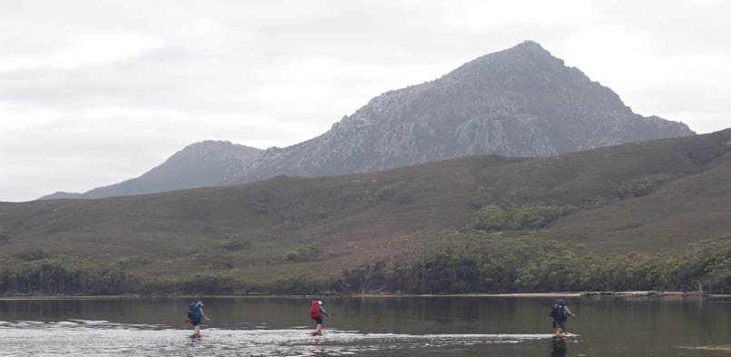
We got to Horseshoe Inlet at about 5 pm, and the tide was high. There is good water where the track crosses a creek about 200 metres before you reach the shore of the inlet. There was no wind, so we ended up camping on the green mossy ground at the shore. Our tents were pitched less than a metre from the water, squeezed into that little strip of green between the water and the trees It was all very peaceful. It would have been a different story if the wind had been up.

Day 6 - An idyllic campsite, if a little cramped

Day 6 - Tides at Horseshoe Inlet
28 | Bushwalk August 2023
Day 7: Horseshoe Inlet to Melaleuca, 11 km, 5 hoursWe knew that low tide was 9.30 am the next day, so we had a leisurely start. The water had dropped a lot, and we waded barefoot about 500 metres along to Horseshoe Creek. One of our crew had the secret knowledge from a previous trip, and we waded along a sandbar to cross Horseshoe Creek, with the water only reaching our knees. The creek scoops out a lot of sand at its mouth to leave deep water, but if you go out far enough, the semicircular sandbar just under the surface provides easy crossing. You need good light for this, as you want to see where the sandbar is, and probably low tide as well. I used an Android app called Tide Prediction (developer Muchoviento.net), which works offline. Just enter Bramble Cove for the tidal station, (just north of Horseshoe Inlet). Note that the tides at Bramble Cove are weird, I assume because Bathurst Harbour is a large shallow body of water, so sometimes there is only one low tide each day. Check before you go, and if you can
plan your trip to cross Horseshoe Creek at a proper low tide, then see the crappy MS Paint diagram below for where the sandbar is. Hope this helps!
After that it was just the 4-5 hour muddy slog back along the South Coast Track to Melaleuca and a massive stash of wine and snacks we had left on the shelves in the hut at the airstrip!
Day 7 - Crossing the bar at Horseshoe Creek
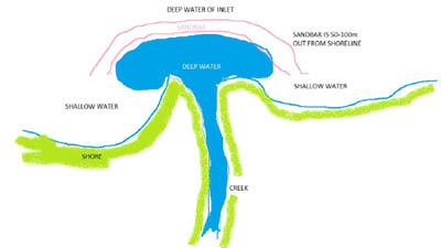
creek
shallow water
shallow water
deep water of inlet
The sandbar is 50-100 m metres from the shore

shore

deep water

sandbar
Bill Bennett was born in Scotland in 1964 and started hillwalking when he was five. He is a professional biologist who moved to Tassie with his family in 2009, and is still trying to wrap his head around curried scallop pies. He likes whisky, hates both porridge and bagpipes, and doesn’t mind rain all that much.


29