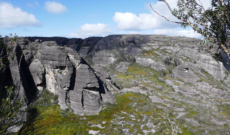
Monolith Valley from Shrouded Gods Mountain

Six Days in the Budawangs
Text and photosBernie Quirke
I acknowledge the Budawang people of the Yuin nation, traditional owners and custodians of the land we walked.

10 | Bushwalk December 2023
June 2007 was my first trip into the Budawangs and, despite the tribulations endured I was hooked. Four days of unrelenting deluge saw Wog Wog Creek, usually a step-across stream, become a 40 metre wide raging torrent. How we managed to cross is another story. September 2023 presented a much more benign forecast and, after a 10 hour drive from Melbourne, the four of us camped at the Wog Wog campground (303931 drop toilet, no water tank) in preparation for an early start.
Somewhat of a mecca for bushwalkers, the northern Budawang Range is inland from Ulladulla on the NSW south coast. A wilderness of towering sandstone cliffs, deep ravines, mesas and sculptured pinnacles makes for great exploring. A tortured topology and thick vegetation, particularly regrowth after fires, are limiting factors. The many caves and overhangs provide a welcome haven in stormy weather.
Day 1: Wog Wog, Corang Peak, upper Broula Brook, 12.5 km, 5 hrsI'd read a 2013 trip report of a Batemans Bay Bushwalkers group exploring the upper reaches of Broula Brook, citing a clearing beside the brook, conjuring the image of idyllic camping. It’s the deep ravine skirted when approaching Corang Peak. Their route headed north from Corang Peak, down a steep unnamed pass (366922 Corang Pass?), more steeply into the main gully then back up through a narrow gap, along the cliff base and down into the brook. We followed this route, a hard slog, and finally reached the former clearing beside Broula Brook and pitched tents in thickish scrub. We were too knackered to do much exploring.
The evening was filled with the magic of competing lyrebirds and the burble of the brook. On exiting the next morning, we found a much easier route - for the next time.
"Clearing" in the upper Broula Brook
11
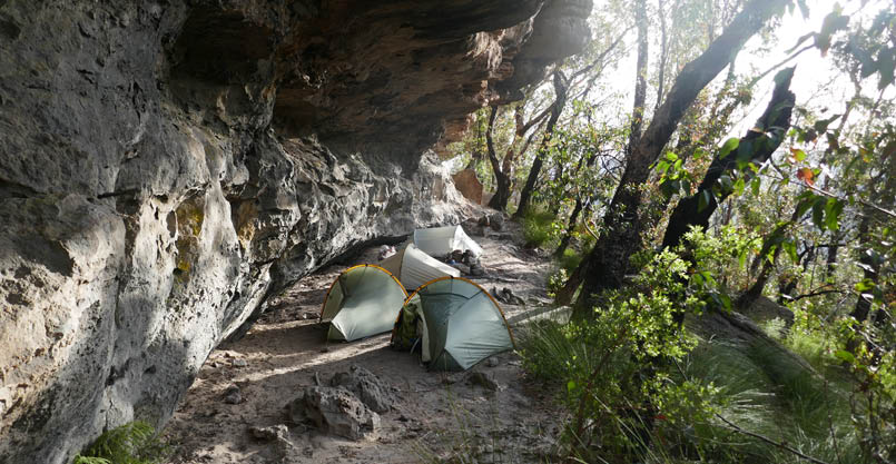
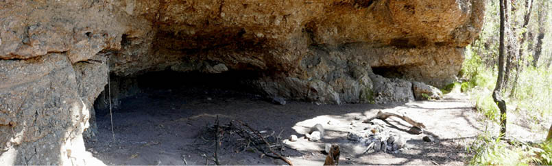
Day 2: Upper Broula Brook to Mount Cole overhangs, 11 km, 7 hrsWe climbed back up onto the Corang Plateau then down to Canowie Brook and were on the well-trodden track. Such had been the dry recent months that usual water sources were reduced to trickles so we picked up a few spare litres from the pools at Burrumbeet Brook and pressed on up the valley towards Bibbenluke Saddle. As it turned out the additional water wasn’t necessary as pools persisted at both the campsite beside the Corang River (419939) and at Viney Creek (430927). Very recent track work provided an easy passage and we arrived at the base of north-west cliffs of Mount Cole in the early afternoon. We dropped packs and went south-west for water at Viney Creek then returned and continued to the most north-east of the overhangs (434930) for a leisurely evening. A colourful sunset ensued and, later, a surprising burst of hail.
Day 3: Mount Cole, Shrouded Gods Mountain, Cooyoyo Creek, 5.5 km, 4.5 hrsNext morning we were greeted with blue sky, light winds and good visibility, ideal for an assault on Shrouded Gods Mountain.
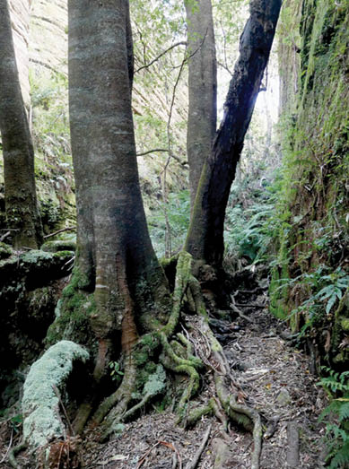
From our Mount Cole overhang campsite it’s a delightful walk up and down, into narrow gaps, below towering rock faces, with remnant beech, mosses and ferns, to break out into the open and confront the Seven Gods, then plunge down into the Green Room and Monolith Valley. A short distance further on we reached the point from which to attack Shrouded Gods Mountain (445921), dropped packs, stuffed the necessities into daypacks and headed for the east-west gully that provides access.
The route into the gully is marked with cairns. As you enter the gully the sheer wall of Shrouded Gods is on your left. Keep to the


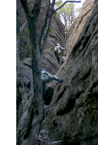
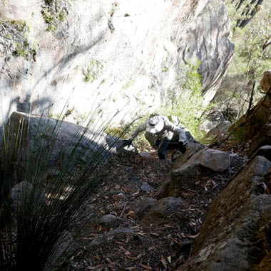
Route into Monolith Valley
Route into Monolith Valley
12 | Bushwalk December 2023
This map is © Bushwalk.com and is created using data © OpenStreetMap contributors

Road, four-wheel drive track, walking track (treed)
Main track, side trip, alternative route
Cliff, major contour line, minor contour line (50 metre interval)
Lake, river, waterfall or creek


Budawang Bushwalk

0 1 2 3 4 km


Start of the walk
Parking
Toilet
Campsite
Picnic shelter
Lookout


13
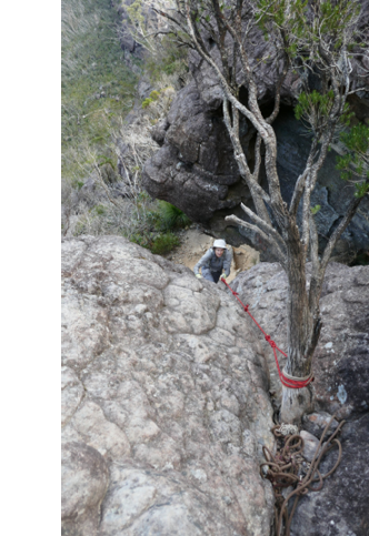
south (right) side and look for a near-vertical cleft on the right that had a black knotted rope when we were there – such fun! It’s a simple climb with a couple of rest points. From the top of the cleft, edge around to the left, then keep climbing. When possible, cross to the other side of the east-west gully. Now the route leads back along the side of Shrouded Gods and begins climbing again until the plateau is gained. Compared to The Castle it’s an easier climb with much less exposure. The views, however, are at least as spectacular.
After exploring the immediate area, we descended, collected packs and continued through Nibelung Pass and down to the Cooyoyo campsite. As it was the beginning of the school holidays, we expected a good number of bushwalkers and 13 of us shared a modest campfire, trip information and a few tall stories. A Dad and 11-year-old were planning on tackling The Castle the next morning and I wondered how they would go. Silly me! They passed us half way up, the 11-year-old scuttling up a rock face with the confidence of a spider.
Seven Gods

Cleft to Shrouded Gods Mountain
14 | Bushwalk December 2023
Day 4: Cooyoyo Creek, The Castle, Mount Owen, Mount Cole overhangs, 8 km, 9 hrsThe route onto The Castle was first documented in 1948 and remains a challenging undertaking. Although The Castle can be climbed without ropes, one section near the top is very exposed and a rope is certainly useful. On this trip we saw ropes had been secured by others in at least six places. Take note, however, of the sign at the base of the climb warning that the ropes are not maintained by NPWS and should not be relied upon.
The start of The Castle climb
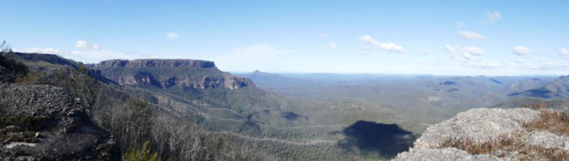
Pigeon House and Byangee Walls from Cooyoyo Lookout

"
The route onto The Castle was first documented in 1948 and remains a challenging undertaking.


15
Having attained the summit, a stroll to the south end was well rewarded with the view of Byangee Walls stretching out to the very distinctive Balgan aka Pigeon House or Didthul. My understanding is that Balgan is the Budawang people’s name for the mountain named by James Cook as Pigeon House. Didthul is the Murramarang people’s name. Both mobs are of the Yuin nation.
Climbing back down and returning to Castle Saddle, we retrieved our packs and headed back into Monolith Valley. We had a choice of retracing our steps to the overhangs or taking the shorter route up over Mount Owen. I’d climbed Mount Owen as a day trip, but with a full pack and more than a few years older, this time it proved to be a challenge. Shorter doesn’t always equal easier.
We lunched at a creek (442922), topped up our water then started the first climb. I’d forgotten this bit – straight up! With lots of hand and foot holds, this climb was quickly done but, with full packs, required some determined effort. Heading west but, with a lot
Pigeon House and Byangee Walls from the south end of The Castle

Exposed section climbing The Castle
16 | Bushwalk December 2023
Mount Cole overhang
of scrambling up and down and surrounded by towering walls, it’s easy to become disorientated. Memory, aided by frequent cairns, brought us to the second climb.
A fallen tree made the climb more difficult but we squeezed our packs through the tangle of branches and continued up to a wide ledge that led to the third and biggest ascent. The steeply sloping gully ended in a final five metre rock face that can be climbed directly or skirted on the right. Hot and wet, we enjoyed the breeze, snapped the classic
Monolith Valley panorama, then set off across the Mount Owen Plateau. With cairns in almost every direction, the route becomes confused but we just headed west to the well cairned descent point into the gap between Mounts Owen and Cole.
With full packs the route up Mount Owen was challenging enough, but the bouldering coming out of the gap was tedious indeed. We were glad to see the first overhang (429926) unoccupied, unlike the group of four that arrived in the dark later that night.

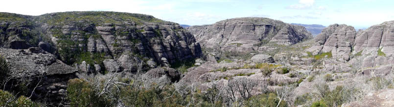
Monolith Valley from Mount Owen
17
Day 5: Mount Cole overhangs to Corang River, 11 km, 6.5 hoursNext morning, finally feeling the benefit of lighter packs, we followed the track back to Canowie Brook, pausing to search for an overhang noted on the CMW Northern Budawang map and mark it for a future trip. As visibility was good, we walked out to Yurnga Lookout to capture the 180º vista of Cole, Owen, Pigeon House, Wirritin and Currockbilly. When weather permits, this short diversion is well worth the effort. We also checked out the best of the Burrumbeet overhangs which, I imagine, would have been an oft frequented camp in pre European days.
We followed Canowie Brook to the rock ribs at Corang River, looking for a campsite beside the water and, a short distance further on, found a sandy spot with shade and pool – bliss. With a short last day ahead, we sat up to the late hours and hit the tents at 8 pm :)
.jpg)
Pultenaea baeuerlenii (vulnerable)
Mount Owen and Pigeon House from Yurnga Lookout
Burrumbeet overhang

18 | Bushwalk December 2023
Day 6: Corang River to Wog Wog, 10 km, 5 hoursA part of the usual track back to Wog Wog crosses private land, but until recently this hasn’t been an issue. Sadly, the current owners are enforcing their rights, so after crossing Broula Brook, we headed off track to skirt the boundary, rejoining the track near Goodsell Creek.
Back at the Wog Wog campground we talked through the high points of the trip, congratulated ourselves on summiting Shrouded Gods, The Castle and Mount Owen, put names to the many wildflowers we’d photographed and, of course, started planning the next Budawangs adventure.
Map references are GPS recorded by the author, UTM/WGS84.
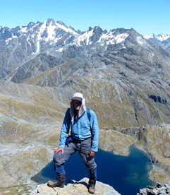
After returning to bushwalking in 2006, having allowed work and life to intervene, Bernie has walked over 6000 kilometres in Australia and New Zealand, averaging more than a month of overnight walks each year. He has a preference for multi-day, off-track, remote walking.
<


Bernie in New Zealand on Sunset Peak with Fohn Lake below
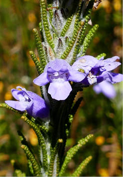

Chloanthes parviflora
Thelymitra ixioides
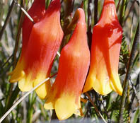
Blandfordia nobilis
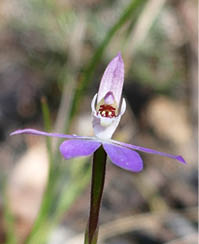
Caladenia fuscata
19