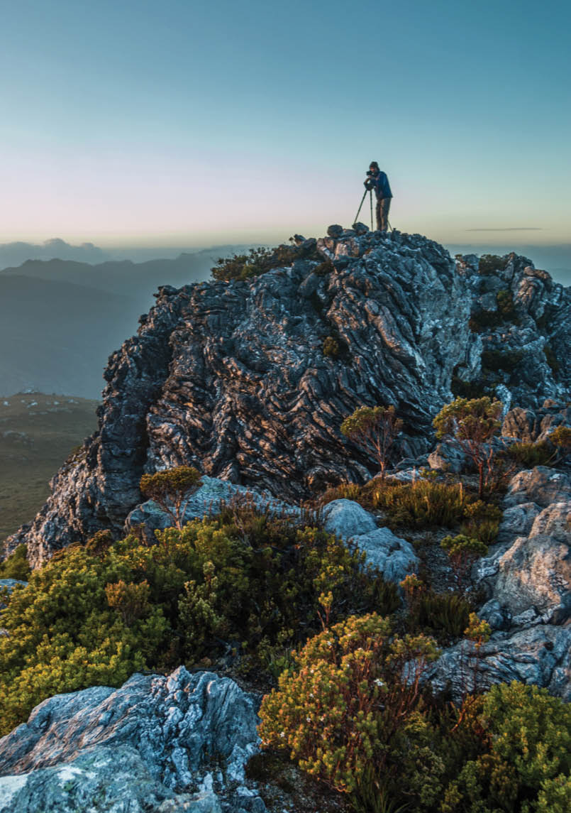


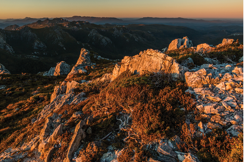
Shooting me, shooting you ... on the morning of day 4NNW
Names matter. And a name like “The Spires” conjures so many ideas and images it’s hard to believe it can be lived up to. But in SW Tassie, on the northern shores of the Gordon impoundment, there’s a range by that name that not only honours the name, but surpasses one’s assumptions of its nature. A glorious wild place with some wonderful peaks, including three Abels*. And it had reached the top of my “to do” list this year ...

The Spires via Holley Basin
North-North-West

12 | BWA June 2017
Solo is my preferred way for most things. (No, I will not elaborate about those things best done non-solo; you can probably guess one or three). This is, not least, so I don’t have to conform to someone else’s timetable or manner, and nor do they have to concern themselves about mine. But every now and then (such as a New Years trip to Nereus in 2015-16) an opportunity arises that makes me reconsider temporarily - although by the time it’s over I’m back where I started: Just. Leave. Me. Alone. PLEASE!
Insanity has been defined as repeating your behaviour and expecting a different result. By that definition, agreeing to go on this walk was the act of a certifiable raving loony ... as was asking me to go along.
Now, I’m upfront about being a certifiable raving loony, just not so much about the hows and whys and wherefores. Which does make it awkward for people to know how to react to my behaviour. Some of it’s just me being difficult. Some of it’s related to my various mental disturbances. Some of it, even I don’t know where it comes from. This is just one more reason why it’s easier for me to do things alone.
Nonetheless, one day, while sitting on her own in a small study in Southern Tasmania, a middle-aged woman suddenly was invited on a particularly interesting route to this place that she was planning on visiting soon anyway. This time it was right, it would work, and there’d be no nailing anyone to anything. We hoped.
Reader, I married agreed to go with him.
We went with minimal information about most of the route, which was off-track and very rarely walked. A quick buzz over the planned route on Google Earth, some notes from recent visitors about the usual access routes to one section, a roughly sketched GPS route, a couple of maps, and we were off.
Day 1 - Walking on waterWe left around 7am, still debating which route to use. We were both intrigued by the possibilities of the Holley Basin line, so that’s the way we chose. Down to the Gordon Dam
boat ramp, unload the kayaks, pack all the gear in, and we were on the water at 10.15am.
It was a beautiful morning, still, clear, shining. The paddle was an easy four hours, just dodging a few partially submerged forests and having one’s mind totally and utterly blown by the rock formations in the Twelvetrees Narrows, then on through the Holley Narrows up to where the lake gave
.png)
Map of the route - yellow is the paddling, green is the walking (believe it or not, they're about the same distance).
“... invited on a particularly interesting route to this place ...
BWA June 2017 | 13

out - which was still some 2 to 3 kilometres from where the maps say the river mouth is located. (Straight line map distance; this being Tasmania, we were not able to walk in a straight line for more than ten steps together). Thus we spent the rest of the afternoon walking on the blue bits of the GPS display. This does make navigation interesting but we had an aid - all we had to do was follow the river.
Note: following rivers is best done without falling into them. This is made harder when the bank is badly eroded. Oh well, it was only two metres down, into only one metre of water and - despite the bag being open and filling with water - the camera did survive ...
Dan had set up his camp on a gravel bar, with another pitchable spot not far away. After repeating to him everything I’d said when falling in (none of which is suitable for publication), I waded another twenty metres up the river to another bar, and found a well established tentsite up on the bank. This was the first sign of past human presence since the boat ramp and the last until a small cairn
on our fourth peak. (It was also the sort of lucky fluke that makes you think your original doubts about the route were ludicrous. More. Fool. I.) Almost made up for the bath.
Admittedly, the bath stopped mattering so much when I realised the camera was still working. I even apologised for all the language.
Dan swears he saw both fish and crays in the river. All I saw was moss, wood, rocks and my feet.
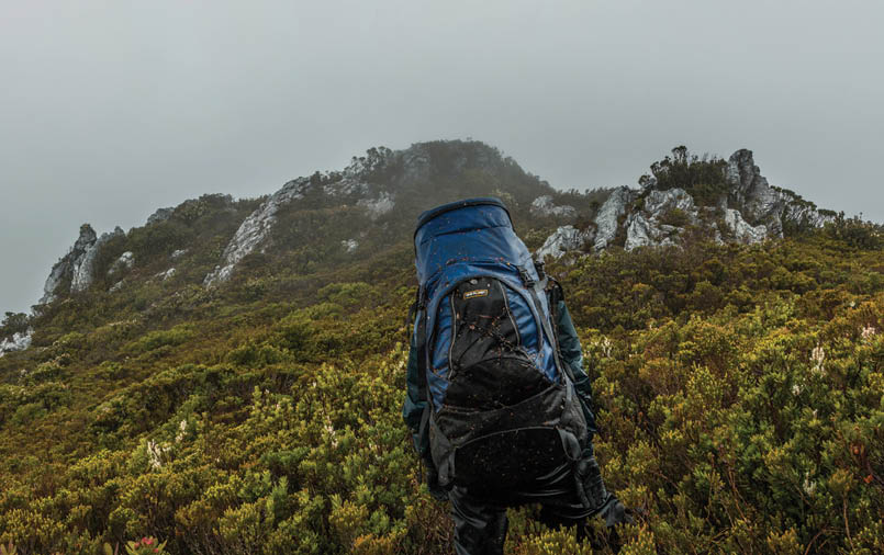
Day 2 - Wet, wet, wetStarted okay and gradually went all grey and damp. Waded up the river until lunchtime, crossing and recrossing continually, with occasional forays into the forest, then pushed through scrub, scrub and more scrub to reach the spur we wanted to climb. We then (mea culpa, mea culpa, mea maxima culpa) crossed a second creek gully and climbed up on to the wrong spur. We finally pitched our tents on a rough, damp saddle late in the evening and hoped it would be better (easier) going the next day. (This spot will forever be known as Meltdown Camp; to protect the guilty - not that I’m saying who that might be - the details of the naming shall be kept private.)
Day 1, I fell in the water, days 2 and 3, the water fell on us
“... we were not able to walk in a straight line for more than ten steps together.
14 | BWA June 2017
Day 3 - Are we there yet?Still grey. Still nippy. Still wet. Still as scrubby as SW Tasmania. Still as slow as a geriatric sloth with severe rheumatism. We made it up to the ridge, and then traversed a series of rocky, scrub-sided knolls that kept getting bigger and higher and narrower and harder and scrubbier. Finally, one gave way to a slightly more open saddle, and a long rib of rock that climbed up towards what looked like our first target peak: Southern Cone. Too knackered to do the short side-trip to the putative summit, we set up another cramped, damp camp in a bowl between the rocks and rested.
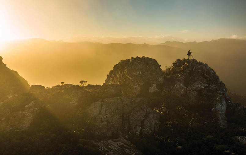
Day 4 - Oops!A late start as there was something strange going on - after a long consultation we agreed it was “sunshine”. So photos were taken, Brocken Spectres admired, gear dried out, and a lovely time had by all while we tried to make the maps fit the observed reality. It wouldn’t, so we just packed up and headed into the next saddle, dropped the packs and toddled off to the lovely little bump out to the side. There were tears in eyes and lumps in throats about knocking off our first peak - until the
mist parted along the ridge and we realised the high point was - as my GPS had insisted - still another 250 metres away ...
Back to the packs. Further along the ridge. Up to the bump. Bumps ... Southern Cone has a double summit. We hit both to make sure that this time it was right, this time ... oh, sorry, I’ve already done that bit. Two whole points*, and it only took three days!
And look - that’s the spur we should have climbed ...
This part of the ridge is a little less scrubby, so we made somewhat better time moving further north, apart from a couple of interesting steep (sheer) scrambles. The final climb up White Pyramid wasn’t too bad once you realise you go around the little cave rather than through it, and we were basking on our fourth point and second summit for the day. Another discussion about which rock was the recognised high point, a leisurely lunch and it was time to try to get down and on to the Camel and the saddle just north of it which was our planned campsite.
The golden boy on the morning of day 4
“Still as slow as a geriatric sloth with severe rheumatism.
“There were tears in eyes and lumps in throats about knocking off our first peak ...
BWA June 2017 | 15

Now, in hindsight, the best route would probably have been to retrace steps a little, do a partial descent, and sidle the steep bits. Not us - we tried to go north; some inconveniently high undercut cliffs stopped that. So we went westish, and jagged our way down through gullies and small cliffs, lowering packs a number of times, until we reached a crux point that required a traverse across a cliff with what looked like a 20 metre drop below.
Along with other things, I’ve also made no secret of my growing vertigo and acrophobia. They’re intermittent fortunately. Well, they decided to hit on that traverse. It wasn’t made any easier by Dan saying, when I expressed doubts about my ability to cope with the traverse, “Well, it’s that or falling off the cliff.” Gee thanks, mate, that helps. He was obviously losing patience, so I gave it a whirl. We wasted over an hour there, until we gave up and found an easier way down to the next shelf. It was a shameful display but that’s the nature of phobias.
It was getting later than we liked here, and the scrub scrubbed up again, so we were making slow progress. At one point Dan went on ahead trying to find a way through the scrub while I crawled along in his wake. He came back and carried my pack through one bit, then went on again. The next time I was stuck, unable to find a route through the thickest stuff, he reappeared. He shouldered through and then dropped the pack, swearing even more than I did when I fell in the river - his GPS had come unclipped somewhere in the scrub.
He got back to his pack, informed me of his intention to camp there, and went looking for the GPS, while I kept going through the dusk to the planned camp. A bit of space was best for both of us.
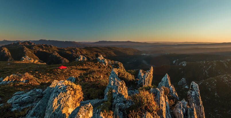
Day 5 - Oh no, not again!Up early, backtracked to the Camel under a grey but lifting and dry sky. Dan reached the top just as I was starting back down to my camp. Packed, a few more photos, another bit of discussion about what had gone wrong and why and how to deal with it (and each other), and on we went again, still marvelling at the chaotic rock formations. You can see
Part of the ridge traverse from False Dome to The Spires on day 5. Kind of fun, actually ...
“The next time I was stuck, unable to find a route through the thickest stuff, he reappeared.
16 | BWA June 2017

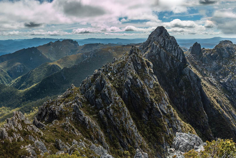
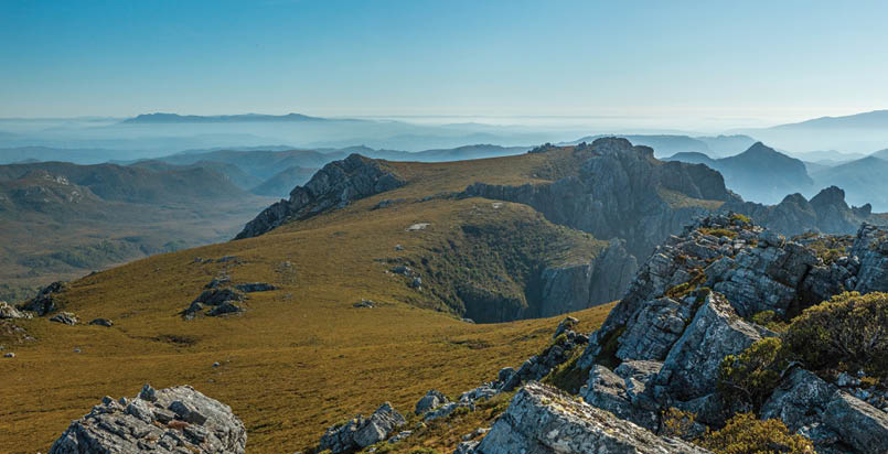
why they called this range The Spires - it’s not just the area above the Font with Flame Peak, the Abel, and its companion towers, the whole range is a jumble of tip-tilted (often vertical) rock; high, low and everything in between.
False Dome was a relatively easy climb and even the descent on the far side and the traverse along the perilous looking ridge simpler than expected. It took a while and a bit of scouting, but there was always an obvious way forward through all the towers and pinnacles. Down to the last saddle after lunch and a steep climb up, a short sidle over a shoulder and up again and we had not only our third summit for the day but our first Abel* of the trip!
Took our time on top - after all, this one is visited a fair bit compared to what we’d just been through. The route onward will be obvious. Right?
Wrong.
This gully? That gully? Down that? Over there? Is that a cairn?
Unsurprisingly, Dan was being a bit overly conservative after my freak out on White Pyramid, so we probably missed a steep but climbable route down and through the next towers. Instead we ended up descending a long steep gully westward and pushing through scrub around the rocks until we were below the saddle above The Font. Then up, Dan again out of patience and heading off quickly to get up in time for sunset to get some decent photos; me, as usual, crawling along as best I could well behind him.
From the saddle, we had a real pad, down to the shoulder above The Font with a small pool for water and a spread of lovely tentsites from where to watch the last light on Shining and Conical and the Denisons.
Day 6 - (Most likely) You go your way and I’ll go mineA glorious morning; clear skies, beautiful light, the peaks behind us being set alight by the rising sun. The perfect start to the best bit of the trip.
The best 2 1/2 days of the trip - from The Font to Shining, Conical and Pokana solo (except for being joined at the second camp). Sunset on Shining's shoulder on day 6.
“False Dome was a relatively easy climb ...
“... we probably missed a steep but climbable route down and through the next towers.
BWA June 2017 | 17

After all the dramas of the last five days, we both desperately needed time alone. Dan headed off to Innes High Rocky for the day, with plans to try to join me at Shining that night, while I was content to take my time, a few more photos, and a leisurely route around the Font, down to Reverend Creek and up to Shining Mountain. No fuss, no rush, no stress even when I kept losing the pad down the moraine. It was a hot day so plenty of rest was taken, and shade eagerly sought.
Reached the high shoulder of Shining mid-afternoon - yes, I’d have had time to knock off Flame that morning after all, but this made up for it. Down to the little tarn below the summit, back up the far side, explored the ridge, giving a quiet greeting to the resident skink on the summit rocks and finding an easy route back to the pack. Then back down for water and a slow and rambly set-up.
Spent the whole evening (apart from cooking, eating and taking photos) looking for Dan and hoping he would think better of pushing on that day. Luckily he did - Innes HR was followed by a swim in The Font and a quick scramble up Flame Peak, and he didn’t leave until the next morning.
Day 7 - Alone again, naturallyThe best night of the trip was followed by the best morning. Another stunner, just like yesterday but this time I had it to myself, along with a perfect campsite in perfect conditions. Took more photos at Shining than any other two days of the trip.
Then pack, along the ridge and a steep descent to the next saddle, past some even more outlandish rock formations than usual, and up to Conical. Here I left a note for Dan (my ancient phone couldn’t pick up a signal there or on Shining) before continuing along the undulating and mostly open ridge, to the deeper saddle before the climb up to the Pleiades ridge.
This route goes through a narrow, steep-sided gully in which I lingered, relishing the cool dampness after the dry heat of the exposed ridges. Bliss.
Finally up on the ridge and serious thought was given to the possibility of a side-trip out to Curly - another mountain I fell in love with at first sight - but it had to be left for now as the map showed it to be further than it looked. Stopped for a break above the final Pokana Cirque lake, where I finally saw Dan sweating his way along to catch up. We pushed on another couple of hundred metres, to camp at the head of the moraine leading to the lake. I graciously let Dan collect our water as he was obviously in need of another swim. Just sooo thoughtful, eh?
Best. Campsite. Ever. (The weather helped). Early morning on day 7.
“The best night of the trip was followed by the best morning.
18 | BWA June 2017

There was a smell of smoke in the air, and it coloured the skies during the evening, but the fire was a long way away.
Day 8 - Three out of threeAnother beautiful morning, but with a thick smoke haze in the valleys.
Left camp first and tried to go over the first major rockpile but it was a long, sheer drop on the other side so backtracked and sidled. Dan was up and facing my direction when I was backtracking so I figured he realised we couldn’t go over. Apparently not, as he made plain when he finally joined me. But it wasn’t too far to the junction of the ridges, where I dropped the pack in the shade of the rocks and headed out to Pokana.
This thing has approximately 57,439 false summits, but the rocks are all so enticing you don’t mind spending the extra time scrambling over them, especially when you stumble over small patches of orchids (Thelymitra) growing in the cracks. It’s also mostly easy open walking. The final scramble is fun, and it’s a shock to see the summit marker - one of those ugly concrete survey pillars - but I was so rapt I hugged it. Ecstatically. Lingeringly. That's 155 down, three to go*.
Dan joined me soon after, looking hotter and sweatier than when we’d met the previous
afternoon (I’d already sweated more that morning than the whole previous two days together). Then back to the packs to make our way along the Pleiades ridge to the Pokana Bay turnoff. This was not made easier by my keeping the notes from a mate’s recent venture into the area on hand, but not the map; the notes said "stay east of the rocks", the map shows a clear line to the west ... Well, we figured it out for ourselves, but the first bit was hard going, sidling steep rock walls through woody scrub, climbing up and up until we crested the ridge.
We reached the northern side of the final rockpile around 4pm and, after being cheered on our way by a flock of cockatoos and having another short break, we went the other way to most walkers, heading west to our last high camp in the saddle at the head of the spur leading down to the river flats.
Camp couldn’t come soon enough - I was light-headed from repeated nosebleeds, and tired from weaving through the bloody buttongrass. Even the photographic opportunities couldn’t keep me from stretching out on the groundsheet and staring at the buttongrass blooms outlined against the sky before finally setting up the tent.
That ridge just screams "walk on me". If only we'd had the time ... Day 8, mid-morning.
“This thing has approximately 57,439 false summits ...
“Dan was so relieved to reach decent water he almost dived into the river fully dressed and geared up.
BWA June 2017 | 19

Day 9 - There must be some way out of hereA few photos in the early morning, of the mist lingering around the high points, and then we started down the undulating, rocky ridge. Some outcrops could be sidled, some we went over. Then we got turned around in the scrub while crossing one final gully until our fearless leader was pulled up by a faint, hesitating voice saying “Errrr, why are we climbing back up this side of the ridge?” Debate was ended by the GPS display. That sorted, we crossed the gully and climbed up, then headed along the last spur almost to its end, before making our way down through a series of leads and wombat pads to the muddy buttongrass flats, and across them to the east branch of the Holley River. Dan was so relieved to reach decent water he almost dived into the river fully dressed and geared up. While he stopped for lunch, I kept plodding on along the river. Past the junction, through the water, the rocks, the occasional scrubby bit where we had to avoid the deeper pools. (But without falling in this time!)
Finally at the kayaks, load, in the water, and off. Easy enough at first where we were sheltered, but further around we’re pushing into a rising SW wind, the water chopping up, which made it hard work and noticeably slower than the trip in. Some days earlier I’d
said “Wouldn’t it be great to spend a night camped by the lake?” and Dan’s eyes lit up, so we were thinking of a short paddle before hauling out somewhere for the night, but there’s nowhere to beach the kayaks much less camp. Thus we ended up going all the way through the Twelvetrees Narrows before spending the night on a low headland just to the west.
The wind dropped overnight. For the first time, despite being at the lake’s edge, we had a mosquito-free night so I could keep the tent fully open. More bliss.
Day 10 - So long, and thanks for all the fishLake is a glass-out. Photos galore. Slow pack, gentle paddle back to the boat ramp, unpack the kayaks, load up the car, one last selfie. Stopped at The Possum Shed for lunch (the burgers there are even better than the Hungry Wombat’s, but no chips).
I covered close to 100 kilometres all up, including the paddling. Dan did an extra 12 kilometres or so (Innes HR and Flame). All off-track, with just a few intermittent pads to make it easier. Dan did the bulk of the route-finding and scrub-crushing, not just because he’s bigger and stronger and better at it, but because he’s so much faster. Mostly I just
Evening light on The Pleiades from our last high camp on day 8
“I covered close to 100 kilometres all up, including the paddling.
20 | BWA June 2017

*For the uninitiated: many, many moons ago, the Hobart Walking Club issued a PeakBaggers’ Guide, a list of peaks and ridges around the state for bushwalkers to use as a hint for possible walks. Each summit is awarded points (decided by an arbitrary and obscure system that is illogical and inexplicable even to its perpetrators). To get the points you have to “touch the very tippy top”; near enough is not good enough. This list has been amended and expanded a number of times and now includes almost 500 summits for a total of just over 900 points.
Abels are one of the major subsets on the list - peaks with a minimum height of 1100 metres and a minimum all-round drop of 150 metres. There are 158 and, so far, fewer than 20 people are known to have complet-ed the lot. Your humble author is getting very close to completing her round, hence the almost fanatical insistence on taking time to get out to Pokana.
NNW is from Tasmania, and describes herself as “shortish, female and crazy.” She has extensive Australian and overseas bushwalking and outdoor experience, starting with the old Lake Pedder aged 13. For the Peakbaggers, she is on 578 points, with three Abels left to climb. NNW has had her photographs published extensively in BWA magazine and calendars, and is in the latest Tarkine in Motion exhibition.


tried not to inconvenience him too much. (This was seldom successful.) But we both agreed that, despite the difficulties, we were glad we did it that way, and not just for the points*.
The gear suffered - our scrub gloves were shredded, as were my rainpants. The gaiters Scott had given us to test were also on their last legs. Shirts, pants and packs were torn in various places. Inevitably, things were lost during the trip, apart from the GPS (no, he didn’t find it): weight, skin, blood, tempers ... also a pair of sunglasses, and for once they weren’t mine!
The thing with walking in company is that there needs to be a degree of compatibility, in both personality and walking styles. Dan and I walk very differently and my personalities aren’t even compatible with each other much less anyone else’s. So, in some ways, the hardest thing was finding a way to make the partnership work. Not entirely successful, but we are still mates so it wasn’t a complete bust. Plus, with all the little fights and make-ups (no, not that sort; keep your mind out of the gutter) we’ve achieved a better understanding.
Still, I’ve made Dan promise never again to ask me on a walk anywhere more adventurous than Russell Falls or, maybe, at a pinch, Friendly Beaches. Mind, I did that after the Nereus trip too ...
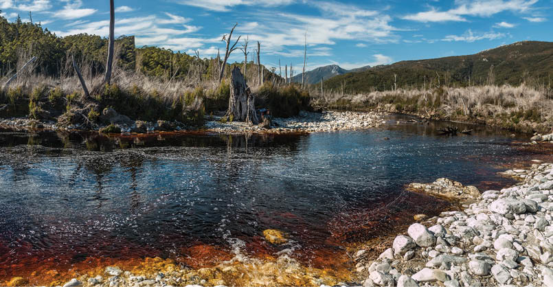
Holley River, near the junction of east and west branches, days 1 and 9


BWA June 2017 | 21