

The Queen Charlotte Track (QCT) is located in the north-east tip of New Zealand’s South Island. This area is known as the Marlborough Sounds and is a geographically unique part of New Zealand. Unlike the fjords of Milford which are glacial formed, the Marlborough Sounds are a series of flooded river valleys. This part of New Zealand is comprised of more than 1500 kilometres of coast and it is this setting in which the Queen Charlotte Track is located, following the ridges and bays of this beautiful landscape. Here are some top tips about the Queen Charlotte Track from Wilderness Guides.
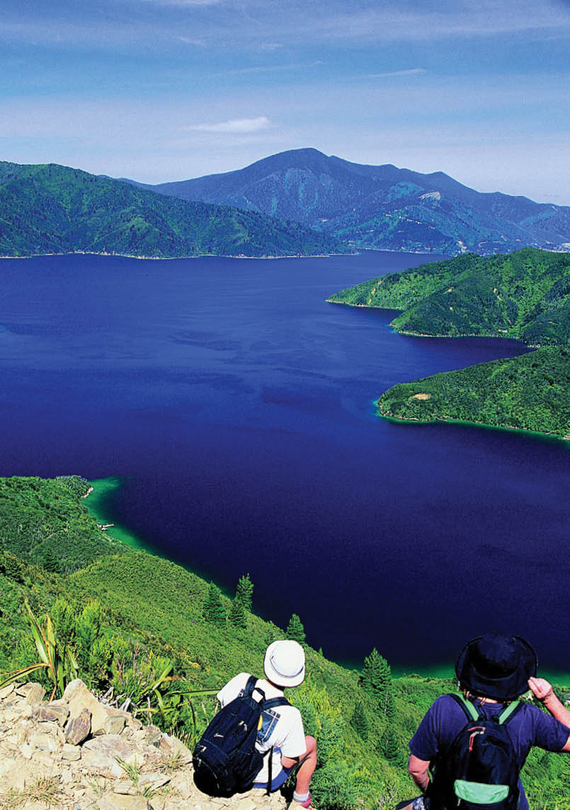
Blackwood Bay, Queen Charlotte Track Wilderness Guides

Queen Charlotte TrackTips From the Track
Juliet Gibbons

22 | BWA June 2017
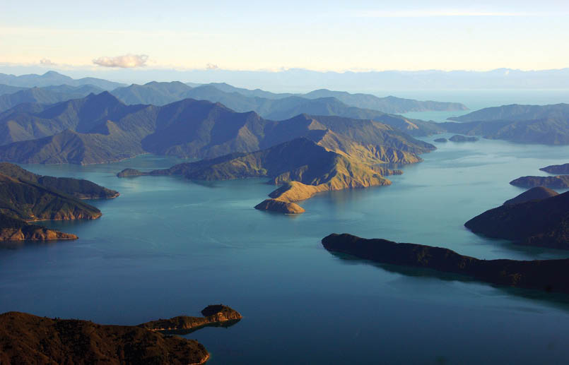
View from a plane, Pelorus SoundWilderness Guides
1 How to get thereThe Queen Charlotte Track is accessed by boat from the pretty little seaside port of Picton (population around 4500) at the heart of the Marlborough Sounds. You can fly from Wellington into Picton with local airline Soundsair or fly into Auckland and then on to Blenheim with Air New Zealand. Alternatively, travel by ferry from Wellington to Picton. All are good options and avoid the current disruptions to State Highway 1 caused by the Kaikoura earthquake. Picton has a beautiful harbour aspect and a great selection of cafes and restaurants – it fair hums in the summertime with a relaxed and friendly vibe. Picton is an excellent place to stay.
2 How fit do I need to be?The 70 kilometre QCT is normally walked over four days and is relatively evenly split – two shorter days followed by two longer days. A good degree of fitness is recommended. The longest day is 23 kilometres and is the most difficult with a climb of more than 450 metres and many other shorter climbs throughout the day. However, there are water taxi options for those that don’t want to walk this section. Walking this section has a reward: the sweeping views across the Marlborough Sounds.
Day
Description
Distance kilometres
Time hours
Comments
1
Ship Cove to northern side of Endeavour Inlet
14
5
This day includes two low saddles, the highest just over 200 metres.
2
To Camp Bay, southern side of Endeavour Inlet
11.5
3
A coastal section with no climbing.
3
Camp Bay to Torea Bay
23
8
A long day along the ridge with a number of climbs, the highest to 450 metres.
4
Torea Bay to Anakiwa
20.5
7
One climb of 400 metres.
“QCT is normally walked over four days ...
BWA June 2017 | 23
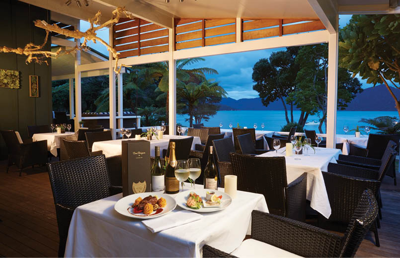

Fine dining at Raetihi Lodge, night threeRaetihi Lodge
3 Turn the mobile phone off (emergency only)Okay, well, you can bring a mobile phone as a good safety device in times of need but along the Queen Charlotte Track, you won’t be able to use it for the first two days. So, it’s a great chance to have a holiday! A Personal Locator Beacon is a great idea and will work as long as it is set up to be used internationally although the many entry and exit points by boat along the QCT means help from the water is never far away.
4 Food and accommodationSorry to disappoint those hoping to shed a few kilograms but the QCT is well known as the gourmet’s track – and for good reason! You won’t need to pack two minute noodles or freeze dry foods. Each night you will find a great restaurant at your accommodation or a friendly host ready to cook you a meal. The best you can hope for is to come out even in the intake versus energy spent by the end!
There is a wide range of accommodation along the QCT from Department of Conservation camping grounds serviced with tent sites, running water and toilet blocks through to backpackers, lodges and even hotels with en suite rooms.
5 For the history enthusiastIf you have a penchant for history, look no further than Ship Cove. It was here in 1770 that the English explorer Captain James Cook found fresh water, strong timbers and a sheltered cove which was to become his base as he and his crew explored the South Pacific. In 2020, New Zealand will celebrate 250 years since that first significant European arrival. If history interests you, then a guided walk will add lots of value to your trip.
The QCT draws its name from the Sound of the same name, which was named by Captain Cook on his first visit in honour of King George’s consort at the time, Queen Charlotte Sophia. Nearby, Cook climbed a high point on Arapawa Island and saw for the first time that New Zealand had two islands separated by a body of water which he named Cook Strait.
6 Guided or independent?One of the great aspects about the QCT is the range of options available. From one day to multiple days, with a guide or without – the choice is yours. The rule of thumb is if you would like an upmarket tour with an emphasis on gourmet food and wine with everything provided including
24 | BWA June 2017
As a journalist on a guided walk writing an article for the local newspaper and then as a guide on the Queen Charlotte Track, Juliet knows the QCT like the back of her hand (or boot should we say). Such was her passion for this track that she and her husband Steve decided to pursue a business introducing others to the track, and have been running Wilderness Guides for 18 years. Juliet now spends her time bringing up two children and marketing the business while a great team of local guides led by Steve continue to deliver a wonderful walking experience for guests.


Steve, Ben (aged 10), Lizzie (aged 7) and Juliet Gibbons
interpretation on the area, then a guided walk is for you. Guided walks are for those who want to complement their walking experience with the knowledge and security of a professional local guide, tasty food and local wine, and superb accommodation. If you are more independent of spirit but would still like certain elements such as your accommodation, transport and daily lunch arranged, then the freedom packages offer this. Unguided track packages are for more independent walkers, who wish to walk the track on their own but have certain elements like accommodation, water transport and daily lunches pre-arranged.
7 Keep an eye out for ...Eatwells Lookout is a must visit on the Queen Charlotte Track. This iconic lookout is on the third day of the track between Camp Bay and Torea Bay. The lookout was created by landowner Rod Eatwell who was instrumental in establishing the track in the early 1990s. This is an absolutely stunning lookout, with 360 degree views across the Marlborough Sounds landscape with its amazing ocean network of bays and coves and worth the steep eight minute side trip from the main track.
8 Bikers and walkersThe QCT is shared between walkers and cyclists, an arrangement which works very well for the most part. The top reaches of the track from Ship Cove to Camp Bay (normally day one and two if walking) are closed to bikers from 1 December to 28 February as these are peak months for walkers. The track appeals to mountain bikers and is not regarded as an easy cycling track although planned upgrades in the next few years intend to address some of the steeper sections.
9 Remember that Crowded House song?Four seasons in one day – yes, Crowded House sung it and it’s true. When you come walking in New Zealand be sure to come prepared for all weather conditions. The QCT enjoys a temperate year-round climate, which means adventure is possible here at any time of year in reasonable weather.
If walking in summer, the temperature can range from an overnight low of around 10° Celsius up to a daytime temperature in the high 20° Celsius region. In autumn the nights are cool, down to 3-4° Celsius but days are still temperate. Winter is often down to zero overnight with day temperatures up to 15° Celsius. Day temperatures begin to warm to summer highs from November onwards.
10 When is the best time to come?The QCT may be walked all year round, although in winter some accommodation places operate with limited facilities. The best time to come is when you can! As February and March are the most popular months, if you are keen to walk then be sure to book early as accommodation does fill some time in advance. Most people tend to book for the most popular months (January to March) the previous winter. Christmas and other holiday periods are also booked many months in advance. Wilderness Guides can help you plan your trip – visit wildernessguidesnz.com for more information.


“Eatwells Lookout is a must visit on the Queen Charlotte Track.
“The QCT is shared between walkers and cyclists, an arrangement which works very well for the most part.
BWA June 2017 | 25