

My original plan for this trip was to do the Huayhuash Circuit, which is about 8-11 days depending on your speed and side trips. As I started researching Peru hikes in general I came across photos of the Rainbow Mountain, which looked amazing! You can visit the Rainbow Mountain on an epic day tour from Cusco, but that didn’t appeal. It involved getting up at 3am or something, sitting on a bus for hours, then struggling, not adequately acclimatised, up to a high altitude viewpoint with dozens of others. I also read that it was theoretically possible to see this bizarre looking hill as a bit of a side trip from the Ausangate Circuit hike.
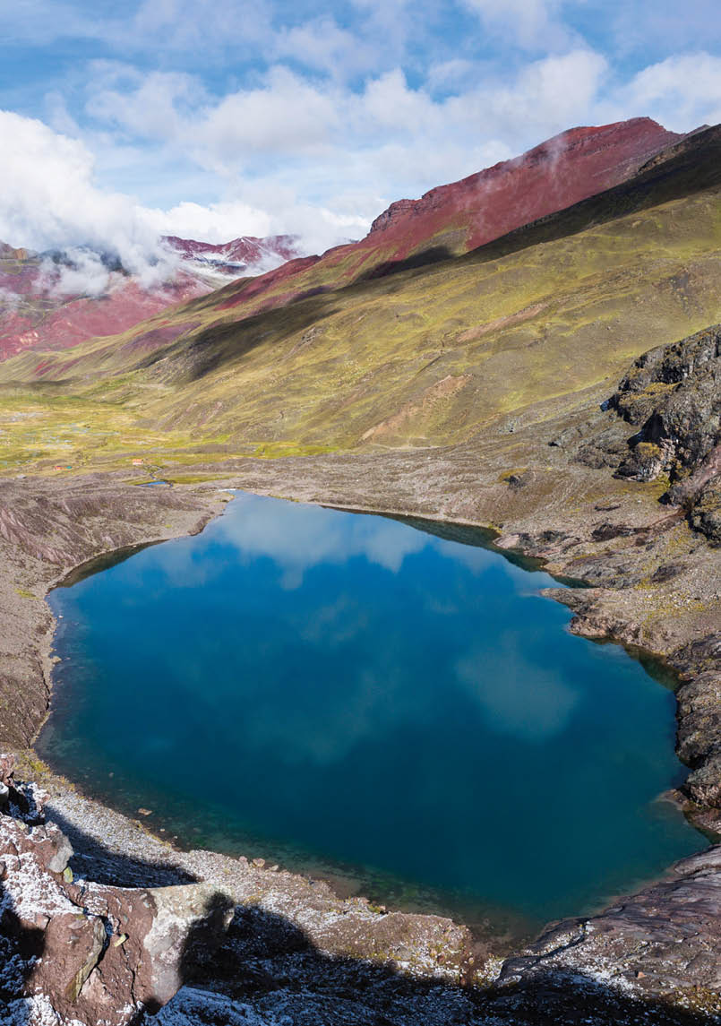
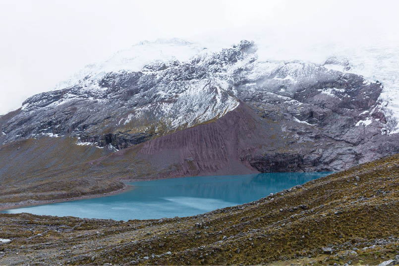
Day 3, looking down on Laguna AusangatochaAll uncredited photos by Drew Echberg

Ausangate Circuit, Peru
Drew Echberg

6 | BWA February 2018

Day 1, almost a view of Ausangate as we walked away from Upis Village
The Ausangate Circuit looked amazing, and I began to think it would be a real shame to go to Peru and not do this hike, especially as it was apparently much less busy than many other areas. My partner Bec, who is sometimes a reluctant hiker, was also pretty excited about the Rainbow Mountain. Over time the Ausangate hike got locked into our plans and the Huayhuash started to get bumped off. I definitely would have been pushing my luck with Bec to do both, a six day hike (Ausangate) and a ten(ish) day hike (Huayhuash), both independently (carrying everything), so in the end we decided on the Ausangate and a shortened version of the Alpamayo Circuit, which a friend had recommended.
Hopefully I’ll get around to doing the Alpamayo report soon. For now, here’s Ausangate.
Day 1, Cusco to Upis Hot SpringsFrom Cusco we caught a morning bus to Tinki (3800 metres), a medium-sized town which is, traditionally, the trailhead for this hike. In recent years as roads have been built and improved, it’s become possible to get closer to the mountains by car and shorten the walk. I guess that the sections that you can now drive have consequently become less pleasant to walk. Previously they might have been walks on footpaths through rural villages and farmland but now they’re dusty
road slogs. We decided to get a taxi (50 soles, A$20) to save ourselves a few hours of reportedly boring uphill slog to Upis Village (about 4200 metres I think).
We’d thought the taxi would leave us only two hours walk from Abra Arapa Pass (the first pass of the hike) and that we might get over the pass and down to a campsite on day one. However, having not arrived in Tinki until 1:30pm (and then eaten a quick lunch), we didn’t arrive at Upis until 2:30pm. The taxi driver had told us that he’d taken us as far as the road went, but it soon became apparent that there was another two kilometres or so of road. We realised we’d only have enough daylight to get to the Upis Hot Springs campsite. This took us about 2.5 hours, including a 15 minute detour where we followed the wrong track. The weather
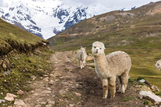
Day 1, alpacas galore on this hike
BWA February 2018 | 7


was mostly fairly gloomy and we only caught a few glimpses of the peaks looming ahead, including the 6384 metre Nevado Ausangate. There were some bursts of late afternoon sun, making the alpaca covered grassy plains look golden and warm. We had one run-in with an overly defensive and quite scary dog, but thankfully our comical trekking pole waving retreat was enough to deter it from biting!
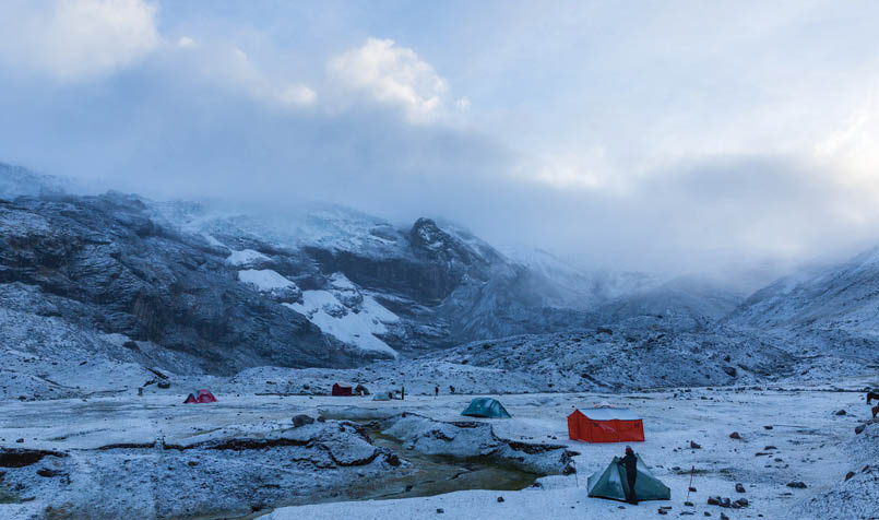
The campsite wasn’t all that nice but the view would be if you got to see it! We saw only glimpses. The campsite cost five soles (A$2), including use of the toilet. There was one other small group with a trekking company. It was a very mild night at about 4400 metres.
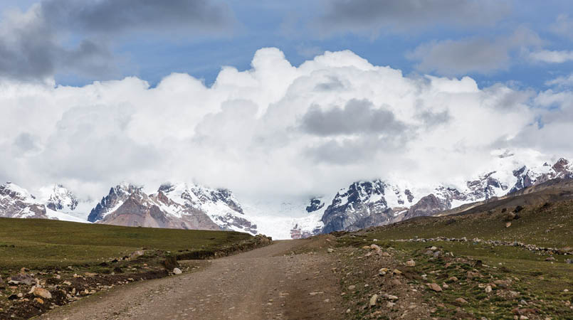
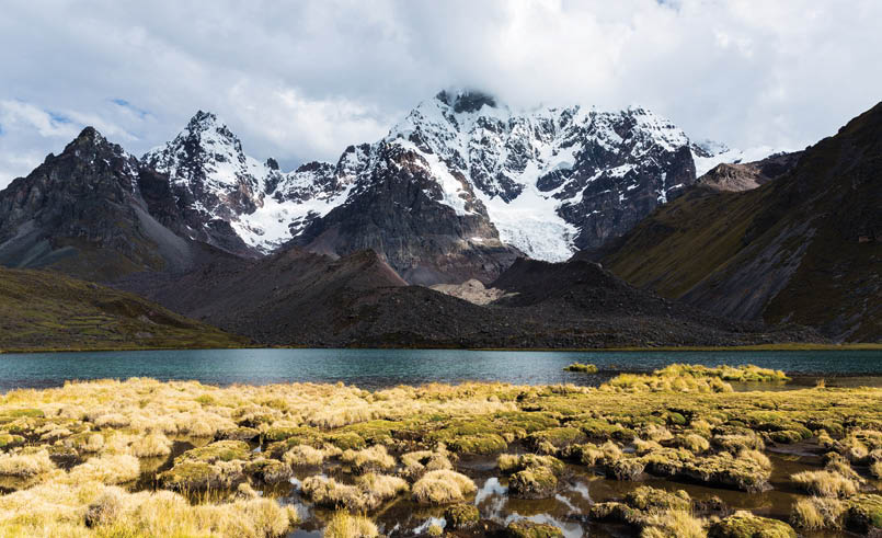
Day 2, Upis Hot Springs to Laguna Ausangatocha (aka Ausangate Lake)After brekky and packing up we backtracked slightly to have a bath in the hot springs. Well worthwhile! We then began the fairly easy climb to Abra Arapa Pass (4850 metres). Unfortunately Ausangate remained hidden behind clouds, with just some views of its glaciers. However, the views at the pass were spectacular. This was quite a bizarre landscape, similar to some that I’ve seen in Iceland. After the pass (which didn’t seem that “passy” - no steep descent on
the other side) we crossed a fairly boggy and slippery area before descending into a beautiful valley, dotted with lakes and lots of alpacas. Unfortunately the weather started to deteriorate and as well as missing some spectacular views we had to contend with freezing rain, thankfully not too heavy. We passed the other group, a little jealous of their dining tent, and had lunch under a rock overhang, staying mostly dry.
After lunch we started climbing, fairly gently, until we reached Apacheta Pass aka Ausangate Pass at about 4850 metres. Despite not being able to see the peaks around us (or much of the glaciers) there were some stunning views looking back along the valley and of the colours in the
Day 2, Abra Arapa Pass
Day 2, lots more Alpacas! Just before the rain started
8 | BWA February 2018

Day 2, looking back along the valley we'd walked through

Day 3, morning at camp after snowfall
hills. The climb to the pass was pretty easy, not having lost too much altitude since the first pass. From Apacheta Pass we descended steeply to the campsite by Laguna Ausangatocha at about 4650 metres. We got the tent up quickly and retreated inside as the showers continued.
There was a toilet building at this campsite but some genius had decided to install flush toilets instead of pits. Of course they weren’t plumbed, so you had to go down the creek to fill a bucket to flush them. Unfortunately not everyone did… I have no idea where the flushed waste went. There were two more groups at this campsite as well as a solo hiker. It's a pretty cold and exposed place, but with beautiful views.
Day 3, Laguna Ausangatocha to an unnamed campsite before Abra Campa PassIt started snowing at about 5am and continued for an hour or so. Then the sun came out and everything was stunning. With Palomani Pass now snow covered we considered staying put but the skies looked like clearing. Soon we’d have other’s footprints to follow so we decided to continue as planned after a visit to the shore of the lake and take plenty of photos in the morning sun.
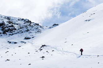
The climb up to Palomani Pass (5200 metres) was tough! I’d been this high before but not carrying a full pack with tent, winter gear and plenty of food. There was also my very heavy camera, which I tend not to include in my gear weight because it makes any attempts at shedding weight seem pointless! The altitude had been messing with my appetite. Even in Cusco I hadn’t been eating as much as normal, but on the hike it had been a struggle to make myself eat much, so I was probably low on fuel. Nevertheless, the scenery was gorgeous! There was an amazing view on the way up, a slight detour from the track up the moraine, looking down over the lake and our campsite with incredibly red hills in the background.
BWA February 2018 | 9


Day 3, slogging it up the climb. It was a tough oneby Rebecca Newman
Day 3, looking down from the other side of the pass
Stunning. Everything was still blanketed in snow and the sun was shining, adding to the majesty of the landscape. From the pass we had more stunning views, although unfortunately the high peaks were still mostly obscured.
After a long descent, passing a few houses and lots of alpacas, we had a leisurely lunch by a river, drying the tent in the sun. Unfortunately the sun didn’t stick around and before long it was very grey again. We got a bit confused about where to go next, lured in the wrong direction by a very clear track, and a bit of a navigational brainfade I must admit! Eventually, with the help of an old lady in a nearby house, we got going in the right direction; inexplicably, there was no track at all for a while. We skirted around a very broad valley before beginning to climb again, following a river into another, narrower valley. At one point we saw a group of walkers quite high above us, so there must have been another route that we could have taken.
We reached the next campsite at about 3:30pm and again were forced straight into the tent; it was raining again and we were both knackered. The campsite had amazing views towards big mountains at the end of the valley, but otherwise wasn’t nice. It was
very boggy, with no sheltered spots that were on dry ground. If the winds came from up the valley we could get some shelter, but not if they came from down the valley. Also, there was another flush toilet here, but with no bucket and with the river 150 metres away, there was no way to flush! As a result they were in a horrendous state and couldn’t be used. This was quite frustrating. One of the reasons we decided to camp at these campsites was to minimise our environmental impact. If there are toilets then it’s best to use them. But when the toilets can’t be used then you get people’s waste concentrated in one area, and rarely properly buried (it's not easy digging in the rocky
10 | BWA February 2018

Day 4, climbing out of the valley towards Abra Campo Pass. Some lazy buggers on horses ahead of us
ground). With all the flowing water, the waste is sure to be getting into the rivers. If I were to go again I’d wild camp.
The rain soon turned to hail and then to snow, about an inch or so. I was very glad when it stopped, as I wasn’t confident of my Stratospire’s ability to stand up to a serious dump!
Day 4, campsite before Abra Campa Pass to Pacchanta hot springsWe woke the next morning to an icy tent - it had cleared overnight, probably dropping to around -3ºC to -5ºC. I’d been worried about the potential for very cold weather on this hike. From what I’d read we should expect mild, sunny days and clear, cold nights, with -5ºC to -10ºC being the norm. We weren’t sure if our sleeping bags would be adequate, and eventually decided to also take my down summer quilt to spread over us. We had bought a cheap closed cell foam mat in Cusco, which we cut in half and each used under our inflatable mats. However, this night was as cold as it got on either of our hikes in Peru, and we were toasty without having to use the quilt.
The pre-dawn light was gorgeous, and I wandered around in the freezing morning air,
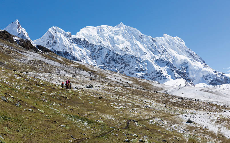
taking photos. The sun finally climbed over a low bank of clouds and it was suddenly warm. We let the tent dry for a bit before starting walking around 8am, climbing steadily but not too steeply. There were lots of alpacas and everything was looking stunning in the snow and sunshine. The climb to the pass wasn’t very steep but it was long. Having a few rests and taking a lot of photos it took us about three hours. The views of surrounding peaks were spectacular.
After descending we ate lunch at an amazing campsite with incredible views where two old women from a nearby village spread out their souvenirs to sell - socks, bags, beanies
Day 4, view as we approached the pass
BWA February 2018 | 11
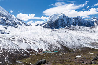
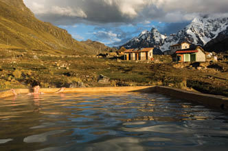
etc. Bec bought a few things and we gave them some food that we wouldn’t need. They told us it was an hour to Pacchanta hot springs if we were fast. We wouldn’t arrive there for 2.5 hours! Those mountain ladies are speedy! Or don’t have a good sense of time… After lunch the weather turned for the worse again, with rain, sleet and icy winds. Thankfully it didn’t last too long. We had stunning views of Ausangate and its glaciers and some beautiful lakes too. It was hard to go past a fantastic potential campsite by a lake, looking towards Ausangate, but the hot springs were calling us. It turned into a bit of a slog, not because the walking was boring (it was beautiful and easy) but because we felt like we’d never arrive. It was well worth pushing on though - we jumped in the hot springs as soon as we arrived at Pacchanta and soaked until after sunset with Ausangate overlooking us. We gave in to temptation and paid a few bucks to sleep in a bed. The only campsites we could see were on sloping ground and the tent was still very wet. It seems like quite a little tourist village has grown up around the springs in a very short period. The road now goes all the way to the springs and it looked like there were tour groups who’d driven there just to stay the night.
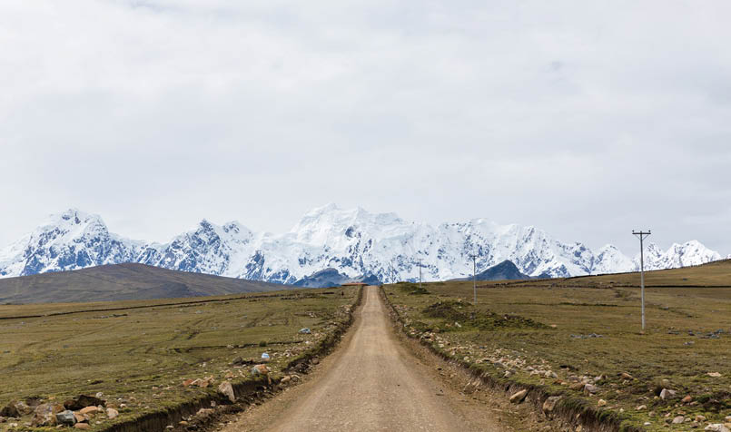
Day 5, Pacchanta hot springs to Tinki, to CuscoAfter eating breakfast whilst sitting in the hot springs, we decided to finish the walk properly by walking to Tinki, rather than getting a ride. Some of the road walking was fairly dull, partly because it was such a grey morning and the peaks were mostly to our backs, but as we got lower and started passing through villages it got more interesting. The day we’d started, Tinki had been very busy, with the market in full swing and some sort of car rally happening. Upon finishing the walk it was super quiet, with very few lunch options. We ordered lunch from a street stall in the square and it was one of the most disappointing post-hike

Day 4, looking back to Ausangate
Day 4, well earned. A sunset soak in Pacchanta
12 | BWA February 2018

meals I’ve ever had! Triple carb delight: pasta, potatoes and rice on the one plate, with just some hints of tomato and some very ordinary bits of trout. We should have found a fried chicken place or just cooked up our last noodles, but we wanted to get on a bus as quickly as we could.
I started feeling pretty exhausted and a bit unwell on the bus back to Cusco. My appetite still hadn’t properly returned so I think I must have burned a lot more energy than I’d put in and was now feeling the effects. There were no lingering problems though and soon we were moving on to Huaraz to start our next hike.
A few reflectionsYou might be wondering why there was no further mention of the Rainbow Mountain in my report! Well, we decided at some point in our planning that it sounded like a bit too much of an ordeal to find it from the Ausangate Circuit. People do it, but it does add at least a day to the circuit and, without being able to accurately place it on a map, we thought it sounded like a bit more adventure than we were looking for. No regrets though: there were some beautiful colours in the mountains that we did see!
Overall it was a stunning hike. Due to poor weather we were unlucky to miss out on quite a lot of views, but what we did see
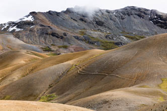
was incredible. There was quite a variety of spectacular and unusual landscapes. The lack of crowds is a big plus for this walk too. I’d originally planned to do the Huayhuash Circuit. There were a few reasons we decided not to, but hearing that it is very busy (especially with large, rowdy groups from one particular country) was a big factor. It’s probably only a matter of time before the Ausangate gets crowded.
It seems impossible to get a decent map of this area. I downloaded a map to my phone and used Backcountry Navigator. The track marked on that map was fairly accurate - experienced walkers should have no trouble with navigation using it. Nor should completing the hike independently pose problems for experienced walkers.
Day 5, a pretty dull road bash but good views if you turned around
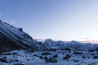
Day 4, our tent at dawn after overnight snow
BWA February 2018 | 13

I prefer walking independently but going with a trekking company would have its perks, specifically not having to lug all your gear up high altitude passes, a dinner tent and lots of hot meals and drinks prepared for you. However I think that the pack animals used cause unnecessary erosion.
If I were going again I’d avoid the established campsites. There are plenty of great spots to camp and I think that, given the toilets that are available, you would actually reduce your environmental impact by spreading out more.
There was water almost everywhere, except near some of the passes (the only time you might carry more than a litre). We always treated it – there were lots of livestock.
It’s cold and the nights are long!
If you don’t have lots of time I’d definitely recommend getting a taxi to cut out the first day, and possibly getting a lift on the last day. However, your acclimatisation will be more gradual if you walk from Tinki.
We flew from Lima at sea level to Cusco (3400 metres), where we had four nights to acclimatise. We’d hoped to do a day hike to
above 4000 metres but only managed to get to about 3700 metres. We didn’t have any altitude problems though, except my lack of appetite.
GearI won’t go into detail about gear but a couple of the main things:
Shelter - I took a Tarptent Stratospire 2, with the solid inner. I bought this recently and wasn’t sure about using it in these high altitude conditions, as I wasn’t sure what sort of winds it could handle. Most nights I pitched with the panel lifters (using Bec’s trekking poles) just in case the wind came up. We didn’t experience any strong winds and the tent was fine. However, it had quite a lot of condensation, including inside the inner (not enough mesh for moisture to escape from I guess). With the long, cold nights I was glad for the spaciousness and large vestibules. This is the reason I took the Strat instead of my Mont Moondance, which is possibly sturdier but smaller and heavier.
Sleeping system - I had a One Planet Bush Lite -11 sleeping bag (-11ºC comfort), with a Sea to Summit Thermolite Reactor liner. My
Day 2, most of the peaks hidden, but still beautiful views
14 | BWA February 2018

Drew is from Melbourne and is a freelance photographer, working in architectural, landscape, portrait, event and fine art photography. He was introduced to bushwalking as a kid and later did a bit of hiking on overseas trips, but didn’t fully catch the bushwalking bug until his early thirties. Drew loves being among big mountains and most overseas trips now are at least partly hiking based. You can see more of his photography at drewechberg.com or on Instagram at @drew_echberg_photographer.

mat was a Klymit Static V Ultra Light, rated R4.4, plus a half length cheap closed cell foam mat. I’m a cold sleeper, and this set up was decided on with -10ºC temperatures expected. It didn’t get close to that cold and I was completely comfortable, without using the Enlightened Equipment Revelation quilt (-1ºC comfort rating) that we’d brought to put over the two of us. Bec had the same mats and an almost 10 year old Mont Aurora, I think rated to -4 comfort (women’s). She’s not a cold sleeper and was also comfortable.
Food - We prepared almost all of our food at home. Dehydrating our own meals and putting together brekkies of porridge, chia puddings etc meant we got much lighter and nicer food than we would have been able to buy in Cusco. We had generous luggage allowance flying over so taking food for two hikes of five days (plus a bit extra) was no problem.
Water purification - We used a Steripen Classic 3, which we’d purchased for this trip. It is a bit heavy but it was very convenient; so much more so than what we used trekking in Nepal a few years ago, the Sawyer Mini, which was hopeless at high altitude. We used the Steripen for our whole trip (eight weeks) and saved a huge number of plastic bottles and a lot of money! I believe that all travellers to the developing world should use some sort of purification device to avoid buying bottled water.
I used a Canon 5D Mkiii, with a Canon 24-70mm f/2.8 lens. Bec used a Canon 85mm f/1.8.
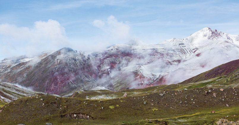
Day 3, a dusting of snow on the red hills


BWA February 2018 | 15