

Battleship Spur
This walk had been under consideration for quite a few years. The fact I had never tried a Queensland walk and it’s sheer remoteness both appealed. A few false starts including booking too late on one occasion meant the walk was now even more enticing.

Carnarvon Gorge Trip
Peter Jessup

12 | BWA October 2018

Wards Canyon
The first thing one realises when travelling to the gorge is its remoteness. The gorge is between Roma to the south and Emerald to the north, some 720 kilometres north-west of Brisbane by road.
After being caught in Brisbane’s peak traffic and buying cooking gas at the last minute it took me over nine hours to drive to the gorge. The drive west, passed through Toowoomba, a country town to rival Ballarat and possibly Geelong in size. Once through though, the road heads north-west into agricultural land, mostly cotton farms.
I reached Roma in late afternoon with another 200 kilometres remaining. The endless roadworks had slowed me somewhat. North of Roma the landscape turns to bushland and rolling hills, but I couldn’t escape the damn roadworks. Stopped at a red light for 10 minutes in the middle of the bush and with the Takarakka Lodge reception closing at 6pm, by this time I was ready to just charge through.
As the light dimmed, bright ochre red beams struck the evening clouds on the horizon to the west, highlighting the mountain range I was slowly moving toward.
The road dropped sharply into a valley while twisting around rocky outcrops. Large brown rocks dotted the roadside and growing larger as I approached. One monolith moved onto the road! *&%$# cattle! They were really hard to spot in the fading light and more so through an insect-encrusted windscreen. Slowing down I weaved through the “cow rocks,” my presence and the vehicle not bothering them in the slightest.
After passing many more animals - including a pair of wallabies standing on the roadside as if they were waiting for a bus - I entered Takarakka Lodge. I missed the office by six minutes but thankfully they had left an envelope with booking details. I had been looking forward to a cold beer but this was not to be.
Takarakka Lodge is well stocked with general supplies but don’t expect to buy screw bottle gas. They do sell metho though. It is a pretty place and very popular with caravanners. I was told cheaper camping was available back a few kilometres but my tent site only cost $20 or so.
“One monolith moved onto the road!
BWA October 2018 | 13
Boowinda Gorge
Entrance to “The Amphitheatre”
Day 1 – to Big BendTotal time 6 hoursThe next morning was sunny and still. Roos welcomed me at the empty Carnarvon Gorge reserve, where camping must be booked and it's only open school and public holidays.
The walk through the gorge is very popular and I pushed through a full bus of old folk as they decided whether to ford the first stream. The gorge is heavily wooded at the start and the track twists through woodland and around rocky outcrops, making for some interesting walking.
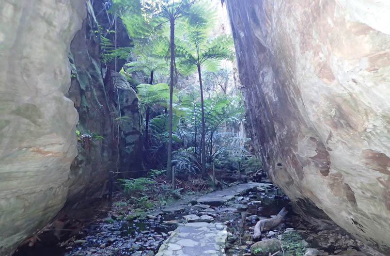
The first attraction is a 650 metre detour to the Moss Garden. It was a quiet and dark cavern with a small stream falling to the lichen-covered rocks below. Very tranquil and worth the walk.
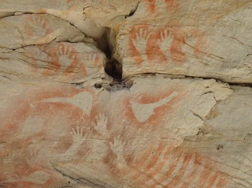
There are similar detours further on including the, Amphitheatre, Wards Canyon, Art Gallery and Cathedral Cave. The latter two attractions have some well preserved indigenous rock art. There's also some more recent contributions from visitors who feel the need to advertise their visit. I wonder if they will call graffiti the carbon age rock art?
The Amphitheatre was visually stunning. A steep staircase leads to a narrow path through a crevice in the rock, and a few metres later it opens up to a cavernous, well, cavern. Apparently classical musicians used to lug their instruments into this open cave and play to audiences. It would have sounded amazing.
The first day was over by mid afternoon, with only ten kilometres walked plus side trips. Allow six hours at a leisurely pace.
Big Bend is a flat and shaded camp on the inside of a bend in the gorge. A beautifully cool waterhole was great on the legs. The towering sandstone wall is just the other side of the river and being a gorge, light is lost very early. There are good composting toilets and a picnic table.
Day 2 – to Gadd’s walkers' campTotal time 8 hoursWalking time - forgot.
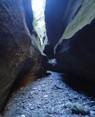
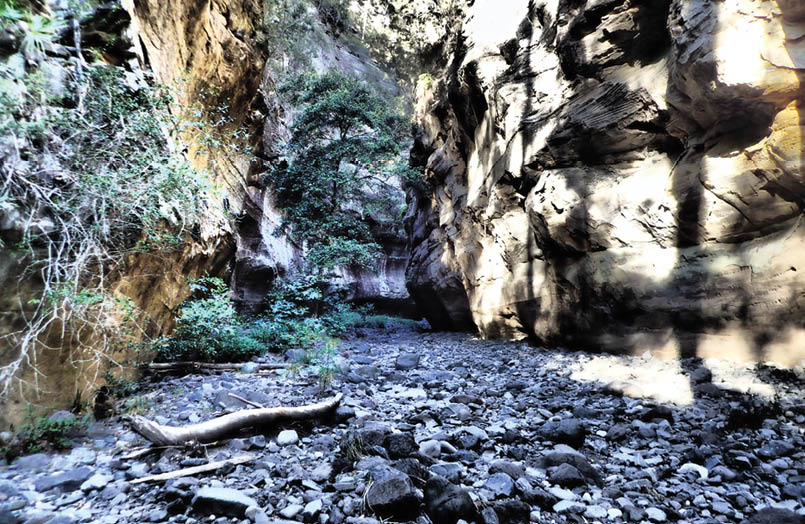
The second day’s feature is a 600 metre steep climb to Battleship Spur. To start the climb the walker needs to backtrack down Carnarvon Gorge and turn right into Boowinda Gorge - far narrower and darker than Carnarvon. This was an awesome start to the day. Boowinda Gorge runs narrowing and snaking through the sandstone, large basalt rocks littering the floor. Tree trunks piled like matchsticks against immovable boulders are an indication of the ferocity of this canyon in flood; today it was thankfully completely dry.
“... the track twists through woodland and around rocky outcrops, making for some interesting walking.
14 | BWA October 2018

A collection of tarns and orange trail arrows marks the start of the ascent. The track starts with a rock scramble through a crevice, quite okay for a fit walker but definitely not for the tourist bus hordes!
The track soon reaches a flat area with a sign, warning the ill-prepared to turn back. This stops day trippers walking through to Gadd’s camp, but seems strange as the Battleship Spur is a good, albeit long day walk.
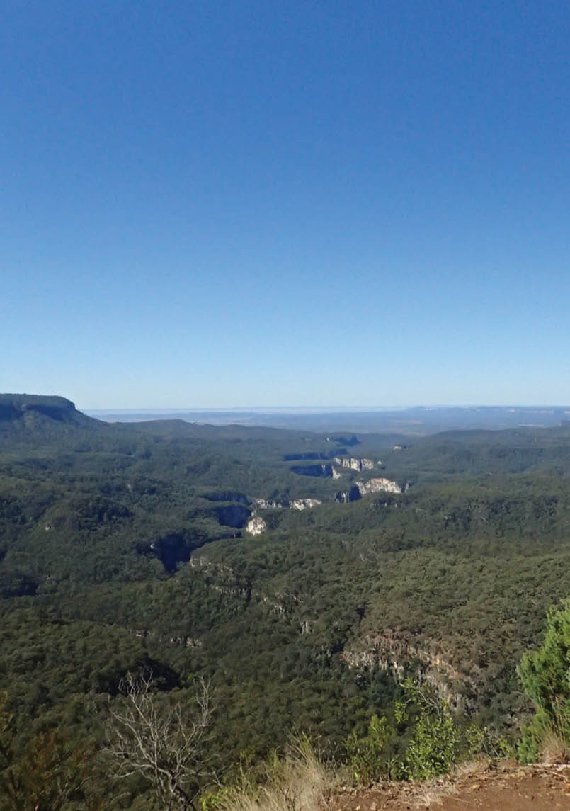
The climb to Battleship lookout took the best part of four hours, very steep and very long. Staircases avoid anything too treacherous but be prepared for a slog, especially with a full pack and a day’s water. Battleship Spur is a slight detour off the main trail and a great place for lunch. Epic views of Carnarvon Gorge are laid out like a map below.
The remaining 10 kilometres to Gadd’s walkers’ camp is mostly overgrown foot track through grassland and cycads. The undulating track disappeared several times and a few more track markers could help. The grass is so dense, one can be 10 metres from the track and not see it.
Gadd’s walkers' camp consists of a good long drop toilet, a shelter and an underground rainwater tank with two hand pumps, which makes a lot of sense as no one can leave the tap on and empty the tank, and the water is kept away from sunlight. Great idea.
Day 3 – to West Branch camping areaTotal walking time 4 hours 45 minutes. Total time 6 hours.
The day is a 15.8 kilometre walk on 4WD management track and foot tracks, with a steep climb in the first seven kilometres past Angelina Creek.
The vegetation is a mixture of eucalyptus and cycads loosely dispersed through grassland. Once atop the first climb, there are great views east across the Carnarvon Creek gorge, 300 metres below, a good place for morning tea.
After a few more kilometres the track leaves the 4WD track, with a well marked left turn and onto single track. The track undulates
Boowinda Gorge
“Epic views of Carnarvon Gorge are laid out like a map below.
BWA October 2018 | 15

and descends into the Boot Creek valley where dry ironbark eucalyptus replaces the greener Cycad grasslands.
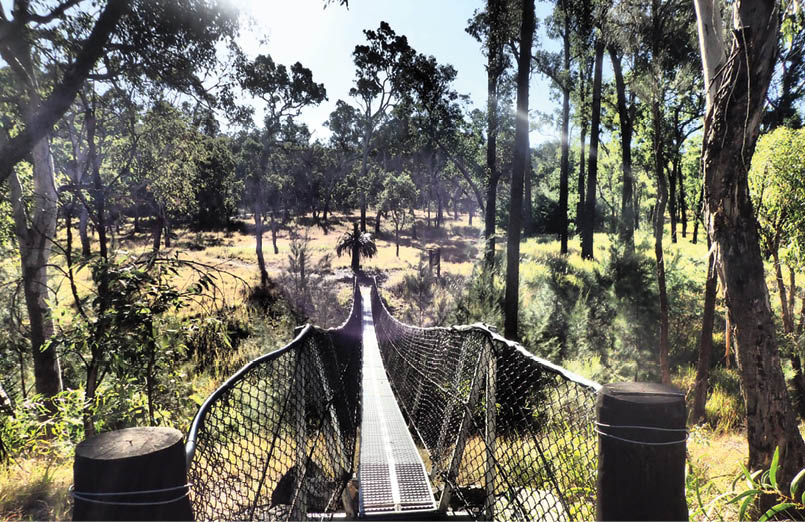
The West Branch walkers' camp is across a suspension bridge and is a 500 metre detour off the main track. This campsite is 200 metres from a drive in campsite, convenient if you have the need to beg a grey nomad for a beer! It is a very quiet spot with only one camper there on my walk.
Day 4 – to Consuelo camping zoneWalking time 5 hours 10 minutes. Total time 6 hours 30 minutes.
The morning began with two inquisitive magpies just outside my tent and a grey kangaroo with an inverted joey just a few metres away. They must have been surprised to see a human appear from the strange blue orb - about as surprised as I was to awake to an audience.
Day four is the longest - 17.3 kilometres with two steep inclines. The track from West Branch ascends gradually through sandy ironbark country and up into the Cycad grasslands again.
All single track, it is in good condition and didn’t disappear on me once, unlike day two. In good condition except for the pig’s relentless digging. I reckon they use the track as a piggy super highway and every hundred metres or so, sniff a buried morsel, excavating six square metres in the process. This can be beside the track, or right in the middle. It makes the track very hard to follow and is a complete mess visually. Some hillsides are covered in these unsightly digs. There must be thousands of the little mongrels out here and they need to be dealt with. There, I feel better now.
The two climbs are not arduous and the peak of the second climb is a good place for lunch.
The afternoon walk passes through the "Mahogony Forest”, a large area of enormous silver top stringybark - very similar to the alpine ash forests in Victoria. The height is now over 1200 metres which would explain such vegetation possibly.
Consuelo camping zone is a picturesque spot in a small valley and well protected. As with Gadd's walker's camp there is a shelter and underground water tanks.
Foot bridge to West Branch walker's camp
16 | BWA October 2018
Day 5 – to Cabbage TreeWalking time 3 hours 40 minutes. Total time 5 hours 30 minutes.
A relatively easy and short walk across the Consuello Tableland, mostly flat and easy walking through more beautiful forest.
About to leave when a rustle in be nearby grass revealed a black pig walking my way. Being a greenhorn Victorian (yes I know we have pigs in Victoria) I tried my best dominant intimidation ... something like gooowwnnn uuuckkkkooffff getouttaeree. It worked. The pig took off for the hills.
In retrospect I was glad of this harmless initiation in pig scaring. The day saw two more surprise pig moments. Almost on top of one of one before we realised each other’s
presence. Pig - “snort” and hasty retreat right across my path. Human “eek” frozen to the spot - replacement underwear please!!
For the remainder of the day I announced my presence with some cursing jibberish every few hundred metres. These pigs are huge and quite mean looking. The piggy excavations continued to be seen throughout the day.
I made camp at 2pm at Cabbage Tree. Another shelter and underground water tank but no toilets. The area is a camping “zone” which means you can pitch a tent anywhere in the vicinity but in reality options are limited as the surrounding grass is so thick and tall. A very tranquil spot though and one bar of 3G Telstra reception.
Day 6 – to the Vistors' CentreThe trail condition of the last day is in stark contrast to the virtual freeway of day five. Immediately from camp the walker is pushing through chest high grass - this continued on and off until the Demons Ridge climb.
Rock art
“They must have been surprised to see a human appear from the strange blue orb ...
BWA October 2018 | 17
The walking on the last day is varied in track and contour, with some magnificent views to the East at the top of Demons Ridge. Further on the walker passes the Devil’s Finger - a rock spire pointing at the heavens - also a good place to stop for lunch.
Soon after, the turnoff to Boolinda Bluff is reached. It is well worth turning left for the 750 metre easy stroll. Once there, the entrance to the gorge is visible, as is Battleship Spur, the peak I lunched on five days prior.
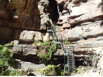
The remaining 2.5 kilometres involves a steep descent down rocky steps and ladders until the main gorge access trail is reached, then a 15 minutes walk to return to the visitors' centre.
That evening at Takarakka lodge, I enjoyed a few beers with the caravan set and had a really great night sharing stories. A few nights a week, they have a roast dinner special for $25, which I highly recommend (need to BYO plate, bowl and cutlery). The crew really looked after this weary traveller and I thank the staff for their great hospitality.
I really didn’t know what to expect from this walk. It is rugged, beautiful and in some sections quite tough. It's something I would certainly not recommend for someone’s first multi day walk. It's a stunning walk.
It is really two walks in one. The first an exploration of the magnificent gorge and the second a taste of the unique and varied Queensland forests.
Would I do it again? At the moment, writing this at the Takarakka bush resort with a coldie in front of me - probably not. But if a few mates showed some interest then who knows.
The best time to walk is definitely in the cooler months as later in the year it is just too hot to contemplate. I walked in late May and every day was in the low twenties and sunny, but beware the nights are very cold, with one night down to zero.
Access to Carnarvon Gorge is varied. I chose to rent a car from Brisbane and drive but it is such a long way. In hindsight, I should have flown from Brisbane to Emerald. The drive from Emerald is about three hours. I ended up spending $150 in fuel, which is the discounted one way flight from Brisbane to Emerald. Or fly to Roma, but this seems to be more expensive. Alternatively, the drive from Rockhampton is only about five hours.
More information
There are also the following links which give more detail about each section of the park, Carnarvon Gorge, Mundi, Rosa and Moffat.
Carnarvon Gorge Wilderness Lodge
Page 13 of the Carnarvon National Park Management Plan says: "Carnarvon National Park has been gazetted to protect its diverse landscapes including spectacular gorges, its outstanding Aboriginal sites and a wide variety of plants and wildlife, many of which have special conservation significance. The park also provides substantial nature-based tourism and recreation opportunities, and plays an integral role in the protection of ecosystem services in the region, such as watershed protection (EPA, 2001). QPWS aims to conserve these values into the future."
Carnarvon National Park lies within Queensland’s sandstone belt, located in the Central Highlands of Queensland, and is a part of the Great Dividing Range. It is also called the "Home of the Rivers", being the source of several major river systems - the Maranoa River and into the Murray-Darling catchment. To the east, water travels down steep-sided valleys, including Carnarvon Gorge, into the Comet and Dawson Rivers. These join the Fitzroy River, which meets the coast near Rockhampton. In the western sections of the park is the catchment for the Warrego and Nogoa Rivers.
“... The crew really looked after this weary traveller ...
“It is also called the "Home of the Rivers" ...
“In hindsight, I should have flown from Brisbane to Emerald.
18 | BWA October 2018
Peter is from Eltham, Victoria and is an avid bushwalker. A fan of longer treks, he has completed the Larapinta Trail, Overland Track (in winter) and the Australian Alps Walking Track, north to south. His next challenge is hopefully the Bibbulmun Track in Western Australia.


Alistair Hartley, Senior Ranger, Sandstone Management Unit, Queensland Parks and Wildlife Service, took time from a busy life – literally fighting bushfires – to provide advice about Carnarvon National Park.
The park is 298,000 ha in size, stretching about 220 kilometres. It encompasses a wide variety of rare and unique vegetation types from Brigalow/Belah and softwood scrubs through to open Queensland Bluegrass plains. It is also home to some rare and threatened fauna, with a number of new ground snails having been recently identified, as well as Glossy Black Cockatoos and Quolls having been found within the park. As well as finding unique flora and fauna within the park, there are a number of high-quality Aboriginal sites. These locations are important, and hold special significance to Aboriginal people, who still regularly visit these areas to conduct traditional activities.
The only bitumen road into the park is the access road into Carnarvon Gorge, with access to all other sections being over unsealed roads of varying quality. These roads are impassable after rain.
The best time of the year to visit is between April and October. These are cooler months, and provide a much more enjoyable experience to the park. Be warned though, sections of the park can drop below 0 °C in the middle of winter, and in summer, temperatures can exceed 40 °C. It is always advisable to have large amounts of water with you when exploring these remote areas.


“... there are a number of high-quality Aboriginal sites.
BWA October 2018 | 19