


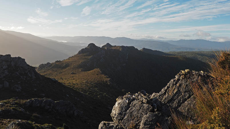
On the Needles ascent, Packers Spur in the left background and The Thumbs across the valley
The February 2019 edition of Bushwalk Australia had part 1 of this series, about Cradle Mountain. The family has now driven to Hobart and is looking at other areas.

Tassie Winter Trip, Part 2
The Needles and Mount Sprent
Peter Hodges

18 | BWA April 2019

The sun slowly lit up the Florentine Valley
Of all the things we planned to do before our trip to Tasmania there was one experience I was looking forward to the most, walking in Southwest National Park. Even though it’s the largest national park in Tasmania it’s also the most remote and the least visited. I was particularly attracted to this as many of the natural sights we have seen in Australia and overseas have been so overwhelmed by human visitation.
After a lot of research I decided that I would attempt to complete two walks, The Needles and Mount Sprent. I only found out about these walks after spending some time on the Bushwalk.com forum. I can’t thank the members of this forum enough for all of the helpful information they provided.
The walks are 1.5-2.5 hours away so I left our Hobart hotel early, aiming to start the first walk just after sunrise. It wasn’t a particularly early start as sunrise in July in Tasmania is not until 7:45am.
There's another fantastic resource that I stumbled upon while researching this trip, StepScape. The StepScape site is working towards showing every published Tasmanian day walk on a single map, with GPS coordinates of the beginning of each walk. It's very helpful to have GPS coordinates for all Tasmanian day walk in one place. So
I plugged in the coordinates for the start of The Needles walk and made the hour and half journey to the start of the track.
The NeedlesI really enjoyed the drive between Hobart and The Needles, particularly the area around Maydena. On this morning mist filled the valleys underneath Tyenna Peak.
The start of The Needles walk is at the highest point on the Gordon River Road. I arrived at 7:45am, just on sunrise and exactly an 90 minutes after leaving Hobart. It was a beautiful, sunny, blue sky day and the early morning light shining on the mountain ranges was magnificent.
At first I didn’t realise that the track started on the southern side of the road, opposite the car park. Thankfully I eventually found a rock cairn. Upon entering the bush I immediately noticed how wet and muddy the track was. I had read from other people’s

The Thumbs from the highest point on the Gordon River Road
“I can’t thank the members of this forum enough ...
BWA April 2019 | 19

The second-highest Needle
experiences that it’s not worth it to try and keep your feet dry, they’re going to get wet and muddy anyway. So I took that advice and embraced the slosh. At first I thought it might be a problem because I was no longer wearing my waterproof boots due to the pain they caused me at Cradle Mountain. I need not have worried though: despite being soaking wet the thick merino wool socks that I was wearing did a stellar job keeping my feet warm.
Even though the walking was very slow going the rewards were almost immediate. Within minutes of starting I could see the sun rising over mountain ranges and the light filling the Florentine Valley.
Within 30 minutes I had reached the first Needle. The views from this point were already spectacular. In one direction the sun was still rising over Mount Tim Shea while in the other there were panoramic views of The Thumbs and Packers Spur.
As I walked through this section it reminded me of why I like walking to mountain summits so much, particularly in remote or hard to reach areas. I’m a school teacher and while I love my job and teaching students I
also relish the opportunity to be alone. The mountains and nature in general are perfect for this.
Another reason why I love mountains so much is due to the gradual way the landscape is revealed. As you slowly gain elevation the picture in front of you constantly changes and the payoff for your effort tends to increase as you climb higher and higher.
This leads to the last reason for my love of mountains. I really enjoy the physical challenge and sense of accomplishment upon reaching the top. Many summit walks can have significant elevation gains or distances covered. As my job mainly consists of standing in front of classrooms speaking or at a desk planning, I absolutely love the physical aspect of walking to mountain summits.
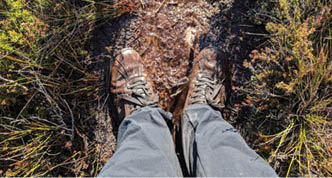
The muddy path to The Needles
“ ... the payoff for your effort tends to increase as you climb higher and higher.
20 | BWA April 2019
Looking back across the Needles
After an hour I had made it to the summit of the highest Needle and immediately added a small rock of my own to the cairn at the top. For such a short walk the views were incredible with mountain ranges and sweeping valleys in every direction. It was a fantastic introduction to Southwest National Park.
The weather was so much better than I expected so I decided to hurry back down and head to Mount Sprent. As I made my way down from the highest Needle I quickly realised that it’s much harder going down than up when walking on muddy trails. Mud in steep sections can be very slippery but rocks and roots on the track were always safer to stand on. For the rest of the day whenever I was descending through a steep section I often muttered under my breath, “Rocks and roots are friends”.
All up it took me approximately two hours to complete the Needles walk which was three kilometres with 300 metres of elevation gain. By now it was 10am and it was an absolutely stunning day. I knew the weather forecast was for rain in the afternoon so I at the car park I immediately headed to Mount Sprent, an an hour along the Gordon River Road.
This is one of the most scenic roads in Australia as it winds its way through numerous mountain ranges to Lake Pedder's
north shore. The scenery is so unlike what you typically see in Australia and it reminded me more of what I have seen in places like Scotland.
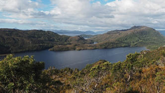
Eventually the drive goes to the tiny town of Strathgordon, the location of Peppers Wilderness Lodge, one of the few hotel-like places where you can stay in Southwest National Park. So I decided to have a look at the area around the wilderness lodge. I also stopped at the nearby Lake Pedder lookout before heading directly to the Serpentine Dam wall where the walk to Mount Sprent starts.
Lake Pedder from Strathgordon

“ For such a short walk the views were incredible with mountain ranges and sweeping valleys in every direction.
BWA April 2019 | 21
Mount SprentI headed along the dam wall and up a series of concrete stairs to the start of the Mount Sprent track. At the start of the track there was a warning sign advising that the track was extremely steep, rugged and remote. After completing the first section of the walk I couldn’t have agreed more: it was incredibly steep, incredibly muddy and very rough. The only way up in parts was to pull myself up with tree roots and a number of timber posts which had been hammered into the ground. The track was like a watercourse, narrow, steep and filled with water. Fortunately this first section was relatively short and the rest of the track was through buttongrass moorland. Even from very early on the views across the Sprent Basin and towards Lake Pedder were stunning.
At about a third of the way up I reached a small plateau where views of the surrounding area really opened up. From this point I could clearly see the ridge that led to the summit of Mount Sprent. The weather was also starting to change as clouds started rolling in from the north.
As I continued to climb the weather really started to deteriorate. Clouds blanketed the sky, it was much colder and the wind picked up. Looking to the north, I could see that it would be raining soon. Nevertheless the weather just made the landscape even more beautiful.
At about half-way up I still had clear views to the south-east while the clouds from the north continued to approach. It was an interesting contrast, blue skies in one direction and storm clouds in the other.
The final section of the walk had all sorts of interesting perspectives of the surrounding countryside. Everywhere I looked I could see layer upon layer of mountains, and the landscape was so rugged and remote. Speaking of remoteness, I hadn’t seen another soul on either track for the entire day. Being able to enjoy some solitude in the mountains turned out to be a real highlight of these walks.
First views over the Sprent Basin on the Mount Sprent track

Lake Pedder from the Mount Sprent track
22 | BWA April 2019

Peter is from sunny Bundy in Queensland. He loves nothing more than spending time with his family, walking in nature and taking lots of photos. When he is not teaching in front of a classroom he is almost certainly on a bushwalk or planning some other kind of adventure.Blog travelwithpete.comInstagram instagram.com/plhodges


When I reached the summit of Mount Sprent it was incredibly windy and it started to rain. Ironically, the view to the south-east was now completely obscured by rain while the view to the north, while still cloudy, was clear for miles. The sunlight was constantly piercing through different sections of clouds and all sorts of interesting and dramatic bands of light shone across the landscape.
After a short time the rain increased and the weather worsened, so I decided to return as quickly as I could. This was more difficult than I thought it would be, particularly due to the steepness and wetness of the track. Nevertheless I made steady progress and still stopped on the odd occasion to take some photos and appreciate the landscape.
After four hours of walking I had returned to the Serpentine Dam wall and travelled seven kilometres with an elevation gain and loss of 750 metres. The Needles and Mount Sprent had ten kilometres distance,1050 metres of elevation gained and lost, and I walked for about six hours. What a fantastic day of exploring in Southwest National Park!
By the time I started driving home it was 3:30pm and I had a 2.5 hour drive to the hotel. I stopped a number of times on the way back, particularly to take in the views of the Sentinel Ranges from the Gordon River Road. It is such a rugged and beautiful landscape. As I reached the half-way point, the sun began to set and I drove the rest of the way in twilight. The last light fell as I drove into the hotel car park, marking the end of a fantastic day of exploring in Tasmania’s remote Southwest National Park.
Spectacular summit views from Mount Sprent
“ ... all sorts of interesting and dramatic bands of light shone across the landscape.
BWA April 2019 | 23