

I crave a remote wilderness experience. And, while I don’t mind meeting the odd party that shares this goal, our little walking group must be particular with its two-yearly excursion destination. With that confession, the Overland Track is ruled out. With a maximum of 60 people being released each day there can be no respite from the cursory greeting and small talk. Seeking a remote nine day experience in Tasmania in early December that avoids the crowds can be quite the task.
Day 2 - The route to Solomons Throne threads through rocksMichael Johnson

Never Say Never
Anthony Kost

18 | BWA June 2019


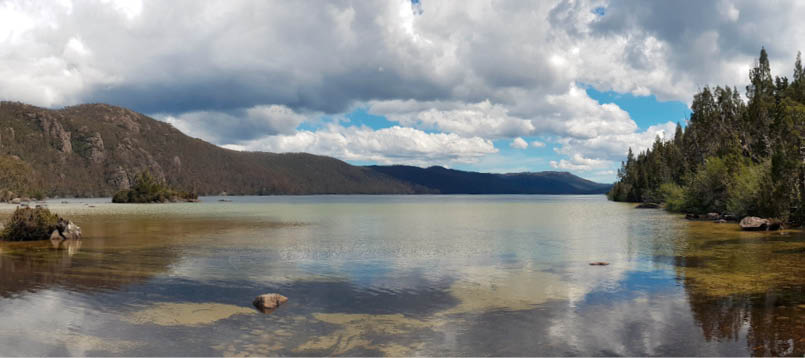
Day 1 - Approaching Wild Dog Creek with King Davids Peak in the backgroundAnthony Kost
Our mission would take us through country the Blisters and Chafers Society have not traversed. We would enter at the Fish River car park, ascend through the gates of the Walls of Jerusalem to Dixons Kingdom. Continue to Lake Ball, Lake Adelaide, Lake Meston and Junction Lake, pick up the Mersey River, tracking through the Never Never to Hartnett Falls. A brief encounter with the throngs at Bert Nicholls and Pine Valley before our exit at Lake St Clair via the Cuvier Valley Route. We would do some side trips at Dixons Kingdom and at Pine Valley meaning a two night layover at each place.
Our planning was thorough. Six weeks out from the departure date of 7 December 2018 we produced eight nights of home cooked dehydrated food, fuel measurements estimated, navigation options laid out and confirmation with transport vendors. We juggled group weight between the party to fulfill airline requirements. Our party comprised four usual suspects: Michael Johnson, Anthony Kost, Julian Nikadie and Rowan Truscott. Apologies from Phil Stringer and Patrick Platt, long-time associates and veterans of previous excursions.
Day 1 - Fish River car park to Dixons Kingdom, 9.5 kilometresAt Fish River car park, we ate a brief lunch, signed the intentions book and distributed some weight so that we were all carrying roughly 20 kilograms upwards to Trappers Hut. Our day one saw a gross elevation gain of 714 metres with a destination of Dixons Kingdom. Our departure time was 1140 hours. It was hot muggy walking, hats and sunscreen prerequisites. By 1240 hours we made Trappers Hut to drink and splash in the stream nearby. By 1530 hours we were at the tent platforms on Wild Dog Creek for more water and a short rest before more ascent through Herods Gate and Damascus Gate, through the native pine down into Dixons Kingdom at 1725 hours. On the wildlife front there were many Bennetts wallabies grazing in the native pine. Our evening meal was a fresh delight of butter chicken. It’s an easy heat and serve. All gents retired by 1930 hours. It had been a long day of travel from Melbourne. Exhausted and joyful.
“Our planning was thorough.
BWA June 2019 | 19

Day 2 - Solomons Throne and surrounds, 7 kilometresThe various possum reports I had read on forums were substantiated. Some time during the evening I was visited by a possum tactical response unit whose core business it seemed, was to sort the evening's butter chicken rubbish bags all over my site.
I took precautions and tied the bag from a branch with a light cord, suspending the bag from all mischief, but no, this crack squad of possums must have used some high level mathematical equations to determine the gymnastics involved to achieve their mission. I heard something during the night but elected to roll over. In the morning I cleaned the mess and dipped my lid at the Dixons Kingdom possum colony. Who dares wins. Nikadie reported a more sombre incident. A rogue possum actually ripped a small hole in his tent in a vain attempt to procure foodstuffs. Nikadie bravely took up arms and with a walking pole at the ready, defended his food bag from the lone marauder.
After our very long day one (timewise), the party enjoyed a 0800 hours sleep in and then enjoyed breakfast in the hut. By 0930 hours we had our day packs ready and departed for Solomons Throne and King Davids Peak. The chaps took the opportunity to check in with loved ones via the Optus and Telstra 4G signal availability, while taking in the 360° views from Solomons Throne (1469 metres). We spent some time with paper maps determining distant and nearby peaks eventually pinpointing our pending route through to The Acropolis and Byron Gap. While there is no track over to King Davids Peak the route is clear, and with a bit of rock hopping we were marvelling once more at a 1499 metre elevation to get a more northerly perspective. We returned to camp for lunch and declared the afternoon one of personal agenda items. The sun was out and quite warm. Johnson and Kost bathed, some napped, some read books.
The evening routine began at 1700 hours with the meal, Johno’s roo stew and mash, being rehydrated and cuppa soups consumed. All done by 2000 hours.
Day 1 - Looking back to King Davids Peak Anthony Kost
“... I was visited by a possum tactical response unit ...
20 | BWA June 2019
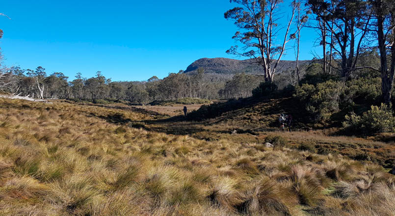
Day 3 - Dixons Kingdom to Lake Meston, 13.4 kilometresDuring the evening we had a very light shower for about 20 minutes and woke to a fog in the kingdom. The fog lifted by 0700 hours. The business of striking camp was calculated at two hours for me; others were quicker. I am a stickler for a porridge breakfast and cup of tea in relative calm so I choose to rise earlier. The other chaps can skillfully shave that time. After the application of sunscreen and a long drink of water we departed Dixons heading down the valley through what is known as Jaffa Vale, an open, soggy buttongrass moorland that leads to Lake Ball. Our first breather at 0920 hours was Lake Ball Hut. This hut was built by Ray “Boy” Miles, a WWII veteran who lived on the Central Plateau in peace battling the demons of war. There was spectacular walking around the lake observing the crystal clear pools and the thriving plant life that springs. A short steep descent from 1148 metres down a tight track to Lake Adelaide (1055 metres) provided some tactical pole work over rocks, tea tree overgrowth and fallen logs. A bonus for walking at this time of year is the wildflowers. The fragrance was intense during some sections and was a signal that after two days we were immersed in nature. We took a 30 minute break at the north end campsite of the lake in glorious sunshine.
The Junction Lake track heads off in a south-westerly direction, and for us, in the heat of the day was pretty hard work. We wanted to swim, but we had a destination. Lake
Meston Hut. For a good three kilometres the track hugged the lake with a steep scrubby ascent on the east side. At the south end of the lake the landscape opens up to swampy buttongrass moorlands that make for a pleasant change and following the pad is quite easy. At another time of year with normal rainfall you would be wet and muddy, and have a good reason to curse Tasmanian mud.
A short photographic break at the north campsite on Lake Meston and then the final push to Lake Meston Hut. If we were to do it again, we would camp on the lake at this north campsite, much more scenic with a little beach and crystal clear water lapping the edge. The Lake Meston Hut is not on the lake and getting to the water's edge is not straightforward, but there is good water flowing at the hut. We arrived at the hut at 1540 hours hot and exhausted. Tent sites are quite limited but we managed to find space for our four tents, and before long, the site went quiet as the chaps retreated to quarters before dinner proceedings commenced.
The evening meal was Johno’s mango and chicken curry, rehydrated for a good hour whilst we sipped on our tasty cuppa soups to rehydrate. This warm Tasmanian weather on the Central Plateau turned our attention to three ordinary rituals:
Sunscreen application at morning departure - no excuses.
Down a good 600 milliliters minimum of water prior to take off.
Rehydrating at the end of the day with at least 600 milliliters.
Day 3 - The view from the northern shore campsite on Lake Meston Michael Johnson
BWA June 2019 | 21
Day 4 - Lake Meston Hut to Hartnett Falls, 10.8 kilometresI awoke to my 0500 hours alarm. No rain last night but it was a bit windy for a few hours. Breakfast was prepared in the hut. The hut is a few notches above Dixons with two bunk beds and a sizeable fireplace. It would appear to be more of a fishing hut with a couple of sets of waders hanging up and fishing paraphernalia hanging around the hut walls. In any case, it's a good refuge in bad weather.
We departed the hut at 0710 hours under clear blue skies and a fresh application of sunscreen. Today is Never Never day. We pushed along the Junction Lake track with fresh legs and a cracking pace marvelling at the rock slopes of Mount Rogoona that meet Meston. A short climb over a saddle and we descended into the Mayfield Flats. The Mayfield Flats are a swampy undulating space between Lake Meston and Junction Lake, with Lake Youd, the basin for many creeks and streams that evolve into life giving Mersey River. With our ideal weather pattern it was lovely walking in the early morning. Pads petered out but generally the track stayed high as it wended its way down the valley to Junction Lake. The sound of rushing water is ever present to the south. We arrived at Junction Lake Hut at 0920 hours and took a packs-off break. Nikadie opened the clinic for some preventative blister work while the
other chaps filled water bottles, drank and sat. We didn’t want to move. The sun was hospitable on our backs and the water was pristine. This hut is in great condition and would be a relaxing destination in its own right.
A 1000 hours departure and the party was in good spirits for the next off-track leg of our day. We attempted to follow worn footpads in the direction of travel, however it became clear we were really just following animal pads. It was easier walking on the higher bumps around the buttongrass plains so we stuck to that, keeping an eye on the lake as it funnels to become the Mersey once again. We picked up a distinct footpad and found the steel post log book box. We
Day 4 - Mayfield FlatsMichael Johnson

Day 4 - Steel post Log book boxAnthony Kost
22 | BWA June 2019
documented our intentions and pressed on. The contour lines became tight and the track was scrubby with tea tree making progress slow and difficult. Conversation lagged as we focussed on the path of least resistance. As we descended we could hear Clarke Falls in the distance but strangely we were in no mood to visit. In retrospect I am not sure why our party did not at least drop packs and take a look.
Navigation wise I found it to be pretty easy in that all you are doing is following the Mersey, keeping it on your left, walking the valley to McCoy Falls.
Eventually we burst out onto beautiful buttongrass moorland with high cliffs on both sides and no sign of human interference. Photographs were few, the moment called for quiet and awe. We weren’t travelling with any sort of urgency, it was just perfect. The novelty of walking on spongy buttongrass moorland was fast wearing off. It's hard going on the muscles and a misdirected foot into a “shinful” of mud triggered the odd expletive. No real footpads, we just fanned out and continued walking along the valley.
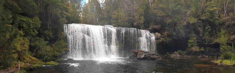
Back into the myrtle forest and soon we were hearing McCoy Falls. There was a good flow. This was gazetted our lunch spot at 1230 hours. We took time to scramble down the bank to marvel at McCoy Falls, though our enthusiasm for a swim dwindled with the reality of the water temperature. We began the final push at 1320 hours. About 200 metres down the river our minister for navigation directed us to cross the Mersey via one of the fallen logs as the going was allegedly easier on that side, as well as the evening’s campsite.
There were some sections of easier walking however there was still some bush bashing to contend with. We emerged onto the Hartnett Falls feeder track somewhat hot and bothered. We dumped packs at the top of the falls and scouted upstream for the campsite that we had heard about. We found a beautiful mossy clearing in the myrtle forest right on the bank of the Mersey. No sign of any previous camps. Retraced our steps to pick up our packs and we landed for the night at 1530 hours. Tents went up and some of the chaps laid down for a short while. Bathing was not appropriate, i.e., bloody freezing.
Master of dinner was myself and I continued the strict routine of rehydrating the meal at 1700. Cuppas, Cup-a-soup, spag bol and a hot chocolate and we were done. This campsite would be remembered fondly by the party due to the Mersey River background noise that lulled us to sleep and anchored us there. Tomorrow we would likely meet overland hikers and this would end our private time in the wilderness. We collectively retired at 2000 hours. I was struggling to tune my transistor radio to any station of interest, strangely the only consistent AM station is radio TAB.
Day 4 - McCoy FallsMichael Johnson

Day 4 - Crossing the Mersey RiverMichael Johnson
“We weren’t travelling with any sort of urgency, it was just perfect.
BWA June 2019 | 23
Day 5 - Hartnett Falls to Pine Valley Hut, 15.2 kilometresThe evening sleep was uneventful. No critters made nuisance. I was up at 0500 hours (picannie dawn) for brekky and a contemplative cup of tea by the river. We achieved our 0700 hours departure and took the time to drop packs and descend to Hartnett Falls for marvelling. By 0750 hours we were reacquainting ourselves with our lighter backpacks and with a gorgeous morning blue sky light we doddled up the Hartnett feeder track. A brief stop at the Overland Track (OT) junction and we were on our way up to Ducane Gap. The better track meant that we were naturally able to increase our clip without the use of the whip. By 0835 hours we were resting and drinking at Ducane Gap. The party were in excellent spirits. At 0845 hours, the mob were on the move and conversation focused on the much discussed Bert Nicholls Hut and the numbers of people we might encounter.
The descent to Bert Nicholls Hut is tricky. Concentration is required with foot placement among the root systems that hold up these magnificent forests. Bert Nicholls Hut has three separate dorms and a huge kitchen. There was a friendly vibe as we explored the site. We rested, drank, chatted with those who would chat with us. But this was not our destination. This incursion onto the OT was brief, a stepping stone to Pine Valley. Surprisingly, not a lot of Overland trackers go into Pine Valley. Bert Nicholls appears to be their last night out, and the following day they make for the jetty at Narcissus Hut. Some do walk the lake but our sample did not prove that statistic.
It was getting warm, the party were running at prime operating temperature and were in flow. Turns were taken for point duty, read that as snake watch. We made a pace of about 3.8 kilometres per hour and enjoyed long periods of silence. We reached the Pine Valley junction at 1140 hours. Johno made the luncheon call by a good size creek, perhaps a river, at 1220 hours. Boots and shirts were discarded and limbs were
immersed in the water. At 1310 hours we were Pine Valley Hut bound, walking through dry scrubby country, crossing the river twice via one person suspension bridges. The country then turned into the pine and myrtle forest once again and became cooler ever so slightly as we went uphill. We met a young track ranger and chatted with him, seeking intel on the Cuvier Valley Route. We got nothing. At 1515 hours we made the hut, bushed by the heat, impressed with the forest. In the spirit of minimising the society footprint we elected to put all four tents up on one platform. It felt like the right thing to do given the scarcity of platforms and flat earth spots. This raised some discussion among the light sleeping brigade and broke section 3 clause 1 of the society code. That clause reads “No gent shall erect any sleeping structure within 10 metres for the purpose of overnight slumber”. We fumbled around with the peg apparatus getting our digs right and then regrouped for a cuppa and set up the camp kitchen.
Master of dining tonight was Minister Truscott with his commercial dehydrated Moroccan lamb and broccoli. We were all sated.
Day 6 - Pine Valley to The Acropolis, 6 kilometresMy sleep was solid. I put ear plugs in early and drifted off. I am told a possum created havoc with my camp cooking utensils over by the hut. Word around the breakfast circle was that a possum must have launched himself at my rubbish bag which was hanging from a hook by the side of the hut, missed and kicked over the kitchen camp kit.
We were up at 0600 hours for a 0800 hours muster to climb The Acropolis. Rowan stayed behind. Two and a half hours up with poles all the way. A few people had said that you ditch the poles when you get to the rock and boulder work. This is not society policy. The poles stay with you through thick and thin. The summit track from the hut goes like this: Pines, pinch, plateau, scrub, boulders, pinch and summit.
The final climb to The Acropolis is technical and exhilarating. For people of my standard it has all the facets of climbing an Australian
“... we were naturally able to increase our clip without the use of the whip.
24 | BWA June 2019

mountain. Not life threatening but rigorous and exhausting. The views are spectacular in clear weather. If there was any low cloud or inclement weather blowing around I would not climb. Just would not be worth it. A young bloke, Oliver, passed me and I found him on one of the Dolomite columns lounging around taking in the view when I got to the top.
We spent a good two hours observing the panorama. There is solid 4G access up there and some of the chaps took the opportunity to touch base with their respective Headquarters.
Back to the hut and we were just in time for the standard dinner routine. Master of dining was myself and I was serving a dahl with couscous and wraps. Tonight was also custard and date night. A one bag wonder and a lot of stirring, it turned out well. It was also decided that a provision of cocoa should be added to personal kit for hot chocolates after dinner. A real spirit lifter. A bit after 2000 hours all chaps retired to the platforms to once again practice what comes naturally at the end of an energetic day.
Day 7 - Pine Valley Hut to Narcissus Hut, 13.7 kilometresIt was windy overnight. The breakfast routine was as usual and we were tracking out of Pine Valley (PV) by 0750 hours. Passing through the many vegetation changes, our cohesive party with fresh legs moved as one and made PV junction by 0905 hours. A decent 25 minute breather was taken here with shirts off. It was humid and the clouds were parting. Pushed on to Narcissus Hut. The valley opened up with views to Mount Byron and Mount Olympus and the Narcissus River became significant on our left as we neared the hut. Arriving at the hut at 1030 hours was problematic and was the seed of discussion as to whether we should keep pushing. There was no need to adjust plans. We were making good walk times and our remaining distance was not overwhelming. We needed to practise the skill of slowing down and immersing ourselves in the countryside. Not so easy. In any case we set up our quarters on the tent
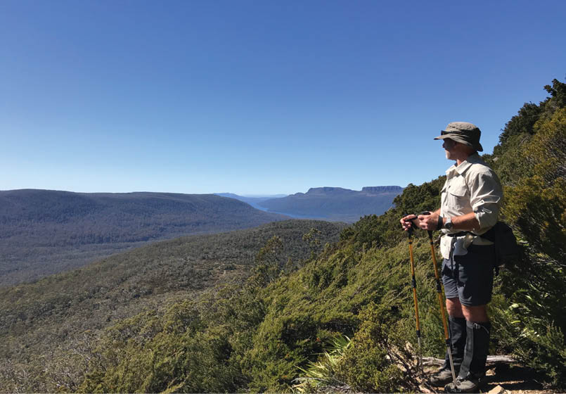
Day 6 - On the track to The Acropolis, with Lake St Clair and Mount Olympus in the backgroundAnthony Kost
“We needed to practise the skill of slowing down and immersing ourselves in the countryside.
BWA June 2019 | 25

platforms and lounged around a picnic table with cuppas and an early luncheon. In the afternoon a swim was in order for me and so I headed down to the ferry jetty. Cold.
Master of dining was once again myself with a potato and pumpkin, cauliflower curry. A walk down to the jetty after meal cleanup. Lights out by 2045 hours.
Day 8 - Narcissus Hut to Cuvier River, 15.3 kilometresToday we tackled another trafficable route, i.e., no maintained track. Our exit to Lake St Clair was via the Cuvier Valley. We were looking forward to another wilderness experience. At 0650 hours, we departed Narcissus Hut in light wind and scattered high cloud. It would be a warm day. This track is not well worn but very well marked; one just has to keep eyes peeled for flagging tape and orange nailed tree markers in the distance. The track passed through cool myrtle forest with lots of water in the gullies. By 0845 hours we reached Byron Gap at an elevation of 1024 metres. The track down to Lake Petrarch seemed to deteriorate in terms of the abundance of markers. There is still an eroded foot pad at times and a lot of bashing through foliage. A gorgeous view of the lake greeted us from downhill vantage points.
As we approached the lake we saw the beach campsite at the other end. We made this our destination for a break. There is no
real footpad around the lake, or if there is we lost it many times through the scrub. We attempted to take the path of least resistance, eventually picking up a pad and came to land at the beach campsite at 1035 hours. Lake Petrarch is a jewel and was a tonic for our party. The skies were cloudless and it was warm. There is a bowling green like lawn on the perimeter of the crystal clear waters of the lake. It is here that we made a significant call in terms of pleasure seeking. We made good time during the morning and if we continued at this pace we would be setting camp too early in a place that may not be as picturesque. We allowed ourselves to lounge here for a few hours and explored the site. No swimming, but the chaps were seen to be nodding off in the shade. We departed at 1400 hours, buoyed by our lazy experience and ready to do battle with more single track and buttongrass plains.
Day 8 - Lake Petrach bowling greenMichael Johnson

Day 8 - Cuvier River campsite with Mount Olympus and Orthys behindMichael Johnson
26 | BWA June 2019
The walking was hot with vegetation, water and mud barring an express-type walking service. We negotiated mostly spindly tea tree branches and a bit of fallen timber. The pad is well footed but not marked. After about an hour's walking we emerged onto vast buttongrass plains, which reminded me a lot of the Victorian High Plains. Good solid marker poles are in place for this section and while it looks tantalising, one must concentrate on meandering the clumps of buttongrass. With Mount Olympus on our left and the Cuvier River on our right and a bit of clean sunny weather the time passed quickly. By 1600 hours we began looking for a campsite. Bowling green type campsites were spotted on the other side of the Cuvier. By 1645 hours we were over the river and had found a suitable site that was not water logged. Packs were dropped and so did we. Not a real long day in distance, and despite the two hour layover, it was tough going.
Tents went up, group water was fetched and dinner was prepared. Kost was the Master of dining and tonight he would be serving a chickpea dahl. We recalled the week’s adventures over our last cuppa soups. I note we had one bar of Optus 4G access in the valley. As the long dusk continued, numerous wombats were spotted foraging on the river flats. As this was our last night out, our food zero policy was enacted and we helped each other out eating excess weight. Evening retirement by 2000 hours.
Day 9 - Cuvier River to Lake St Clair Visitor Centre, 4.5 kilometresLight showers overnight and low cloud over the range in the morning. The Mount Olympus peak that we navigated by yesterday was nowhere to be seen. No porridge for me this morning as it would appear that I miscalculated. No problem, a muesli bar and a cup of tea would ease me into the morning routine and if all went well we would be celebrating with food of some sort at Lake St Clair. It was a cool morning and we struck camp at 0800 hours with jackets on and knowing that our first task would be to cross the Cuvier. We knew we
didn’t have far to travel this morning as this was planned a few months ago and with fresh legs and a dose of “end of walk” fever we were thrashing through the last of the buttongrass and then a formed track into Watersmeet. The track on the other side of the Watersmeet bridge grows to three metres wide. We all felt a bit agoraphobic under the circumstances. We dropped into Fergys Paddock to inspect that as a last mile campsite. It was nice enough but it did have the space to be busy. The gazetted end time at the visitors centre was 0930 hours. We made our way to the Lake St Clair Lodge Cafe and perused the fare on offer. It was still pretty quiet at this point as most of the Overlanders would not arrive for another couple of hours, which was good because our party had to ease its way back into gregarious living. We sat up at the table and ordered eggs and coffee. Spirits were high. It was only here that I became aware of the bodily smells of nine days out. No big deal but by god that shower at Launceston was going to be the ticket. We had time to kill. Our transport was not due until 1300 hours. We lounged through the breakfast watching the international tourists come and go and bit by bit the chaps departed and did their own thing. I went and signed the intentions book indicating a successful walk and browsed the Visitor centre.
Just as an aircraft has to do circuits to dump fuel under extraordinary circumstances, I set up the Soto Muka in the stone hut nearby and boiled water for numerous cups of tea before dumping 500 milliliters of shellite. There is fuel dump bin near the Visitors centre for those of us that cannot take our fuel home on the plane.
No nine day wilderness excursion, well executed, can fall short of expectations and this did not. In the fullness of time we shall return to another iconic Tasmanian destination.
Anthony lives in Melbourne and walks when he is not working in IT. He has been walking with the Blisters and Chafers Society since 2005.


“It was only here that I became aware of the bodily smells of nine days out.
“... our food zero policy was enacted and we helped each other out eating excess weight.
BWA June 2019 | 27