


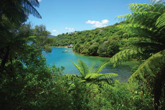
The Queen Charlotte Track (QCT), is graded an easy to intermediate tramp through the Marlborough Sounds in the South Island of New Zealand. The QCT is part of the 3000 kilometre Te Araroa track which stretches across the North Island and South Islands from Cape Regina to Bluff. The walk varies from secluded bays to inlets with clear turquoise water, to coastal forest and then steep climbs to open ridge with stunning views and a lot of history.
Lunch spot just past Shamrock RidgeAll pictures by Aaron Watson

Queen Charlotte Track
New Zealand
Sonya Muhlsimmer

6 | BWA June 2019
Karen, Sonya, Aaron and Stephanie at Ship Cove
You can do the QCT over three to five days, and there is a range of accommodation available along the way from camping, farmstays to luxury resorts. Oh, you can even organise to get your rucksack transferred to your next destination so you only need to carry a day pack every day. There are spectacular views along this track which include the Queen Charlotte Sounds and the Kenepura Sounds. Captain James Cook was the first European to set foot in New Zealand way back in 1770, and spent some time in the Queen Charlotte Sounds in a small bay that he aptly named, Ship Cove. He used it as headquarters, and even returned to this spot on two other voyages. Ship Cove is where the QCT starts.
I did this walk with my sister Karen, and her children Stephanie and Aaron, 18 and 16 years old. Karen went to Ship Cove a few years ago on a day trip organised through the Scout Jamboree they were attending, and Karen wanted to come back to do this walk. I love any kind of multi-day hiking, especially in New Zealand and was keen to do this trip as well, so off we went.
The walk starts at Ship Cove, and the usual way to reach Ship Cove - or Meretoto, the traditional name - is by a cruise ship, which takes about an hour from Picton. Along the way you get an interesting commentary from the skipper about the wildlife, scenery and the history of the area.
Day 1 - Meretoto, Ship Cove Bay to Endeavour Inlet, 15 kilometres Once the bay was reached and after spending some time enjoying the foreshores and reading the history of Captain Cook at the memorial, the walk starts with a 240 metre climb through the lush thick bush, and muddy track. I thought this was supposed to
be an easy walk! This climb definitely warms you up and after reaching the top, a small platform is beckoning you for a break with already stunning view of the inner and outer Queen Charlotte Sound.
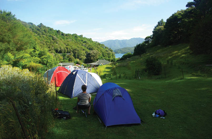
Then the track headed downhill to Resolution Bay and at the bottom is where lunch was called. The track is really easy to follow with many spots to take a break, and all the creeks have wooden bridges so you don’t get wet feet. The track notes are also fairly accurate, but lots of breaks were taken to enjoy the views. Today’s walking time was around eight hours, but the track notes said it can be done in five hours. Endeavour Inlet was reached and it was time for dinner. Karen booked us in for a home cooked dinner at the local farmstay - which is either a bunk or a double room in the house on the farm - but our accommodation was in our own tents which we pitched on the farm in among the orchard. The farm grew the salad, vegetables and even the meat. The owners offer eggs, breakfast and a packed lunch if needed, for a fee of course. The campsite has a shelter, toilets, a basic shower and a large tank of water which is filtered so it does not need treating.

The first 200 metre climb at Ship CoveSonya Muhlsimmer

Resolution Bay
BWA June 2019 | 7
Day 2 - Endeavour Inlet to Camp Bay, 11.5 kilometresEndeavour Inlet was inhabited by local tribes, and then in 1770 Captain Cook explored and named this site, then in 1874 gold was mined. This bay has a rich history. After dropping the rucksacks off at the wharf, the walking begins with a day pack. The highest point today is around 50 metres as the track follows the shore with plenty of stunning scenery to view. The turquoise coloured water against the rugged coastline was so beautiful, the views kept on getting better. Camp Bay campsite was reached in seven hours, a little longer than the track notes suggesting five hours, but who is counting? This campsite provided a small shelter, pit toilets and water on tap from a tank. Treating the water is not necessary but some signs say it is recommended.
The rucksacks were at the wharf waiting for us, then camp was set up for the night.
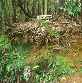
Camp Bay campsite is in a gorgeous little bay, and I could not resist getting into the water, which was the perfect temperature for cooling off. After the dip it was back to play some serious games of cards till it got dark, then to wander down to view the small nook near the bay where the glow worms live. There were not that many glow worms but it was a real treat to see them.
Day 3 - Camp Bay to Cowshed Bay, 23 kilometres, 8 hoursStephanie and Karen decided to pull out here due to pre-existing injuries that were slowing them down, so they organised to get picked up at the wharf in the afternoon to go back to Picton, but Aaron and I continued. This was the hardest stretch along the QCT, a lot of kilometres and the track undulates, as my nephew said: “You go up to go back down again.”
Not long after starting we reached Kenupuru Saddle, then followed the ridge which separates Queen Charlotte Sound and Kenepuru Sound. Two hours later the turnoff to a side trip up to Eatwells Lookout is reached. The short steep ascent takes you to 474 metres and one of the highest points along the QCT. The views, and the hill, will take your breath away and are well worth the effort. I am pretty sure I could just see the North Island peeking through the clouds. This is the side trip I recommend doing if you choose to only do one. There is a bit of a long story about the QCT as it has come about with a joint project between private land owners and the Department of Conservation (DOC), and Rod Eatwell, the largest private land owner. They have been credited for making the track happen, so this lookout has a bit of nostalgia attached to it along with some amazing views. After a break it was time to get back to the track and continue the walk; we still had quite a few kilometres to go. Walking along the ridge the views are just spectacular so many stops were had to rest, eat snacks and of course to take in the scenery.
This is where the glow worms live, back after dark to check them out
Just past Eatwells Lookout
“... the views kept on getting better.
8 | BWA June 2019
Onwards along the track the view down to the Bay of Many Coves was reached where a DOC campsite is located, and further along is Black Rock Station, also a DOC campsite. If you do not want to walk the whole 23 kilometres you could stay at either campsite, but note that there is a warning that water is scarce and the campsites are closed.
After the Bay of Many Coves views, Manuka Lane was reached covered in Manuka shrubs, and gee the view from here is breathtaking, time for a rest to soak it all in. As I said the views got better each day. Once Torea Saddle was reached, it was down to the Portage Resort Hotel to pick up the rucksacks, then onto the campsite for the night. Aaron and I completed 25 kilometres in nine hours, which included the side trip to Eatwells Lookout.
Day 4 - Cowshed Bay to Mistletoe, 8 kilometres, 4 hoursToday was relatively easy, considering the kilometres to travel, however the body was a bit tired from the day before and we still had a few good climbs on the agenda as we followed the ridge. We took the rucksacks back to the hotel for the pack shuttle and then we were on our way. Just as Shamrock Ridge was reached, Aaron saw a small sign under the seat so it could have easily been missed. He never misses anything as he is so inquisitive. The sign was made out of stone with pictures imprinted on it that seemed to say something like "in seven minutes a view will be reached", so on we went. Well, just like the sign said, I think, we came to another stone sign just off the track with an arrow pointing up. It seems this side track is hardly used as it is all overgrown and could easily be missed again, which is not common on this walk as the tracks are well worn and maintained. We took the track and came to a view worth stopping for, oh and it was lunch time anyway. There was a seat, a table, and the almighty view. After lunch we were on a mission to get to Mistletoe Bay and rest for the remainder of the day. Te Mahia Saddle

Kenepuru Sound from Torea Saddle
“... so this lookout has a bit of nostalgia attached to it along with some amazing views.
“... Manuka Lane was reached covered in Manuka shrubs, and gee the view from here is breathtaking ...
BWA June 2019 | 9
was reached in good time and at the turnoff to the bay there was a sign saying there is no accommodation or room available at the bay. We didn’t book anything. As we were just in a tent and the next camp spot is another 12.5 kilometres away, we didn’t want to keep walking. We went to the bay anyway as that is where our rucksacks were being delivered so I thought I would just ask if we can squeeze one small tent in somewhere. It was around 2pm when we reached there and our packs weren’t being dropped off till around 4pm. Well, we were in luck as they don’t turn QCT trampers away. Waiting for the packs to arrive we explored the bay, and had ice cream, and chips at the local shop right on the bay. This is a very picturesque bay, and very popular. Every bit of spare ground was taken, it was packed. During the evening, and into the night more cars came, and just when you thought no more could fit, even more cars came. Tents were literally touching each other everywhere. That was the Mistletoe Experience ... Today’s section was only eight kilometres, and completed in around four hours.
Day 5 - Mistletoe to Anakiwa 12.5 kilometres, 4 hoursToday is the last day and the home stretch. The track goes up to the ridge, and with more spectacular views here, but we are on a mission today to get back in time for the boat so on we walk. After walking for a few hours, Davies Bay campsite was made in good time so lunch was called. We only had a short distance, less than an hour to go to Anakiwa, so a little time was spent soaking in the views, and playing with the resident duck who was hanging around. Aaron was determined to touch it, but the duck had other ideas ... The last section was in the forest, with some views along the way, but when you finish the track it opens up and you are right on the bay with so many people around. It was packs and shoes off and a drink from the coffee cart to relax while waiting for the boat, which came right on time at 3.30pm to take us back to Picton.
I am so glad we were not carrying heavy packs this trip, and for Aaron, his first multi-day hike; it made it a much more enjoyable experience for him. Aaron wants to come back, hire a bike and ride the track next time. Karen and Stephanie want to return to
The Mistletoe Bay experience
“ ... we were in luck as they don’t turn QCT trampers away.
10 | BWA June 2019


complete the track from where they left. And me, I might just have to do the track again to do the other side trips, and I might even try out the resorts on offer.
QCT overviewThe track undulates and the highest elevation is under 500 metres, so it is not that high to climb, however there are steep hills to climb and that can be tough going. The walk can be hard if you are not used to walking for kilometres or hours on end for a few days; it
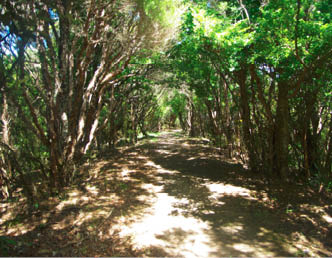
is a long track. You can have your rucksack carried by boat so you just need a day pack, making the climbs somewhat easier. There is no navigation required as the track is easy to follow the whole way. Every five kilometres there is a marker that tells you how many more kilometres to go. You can walk it with a guide, or go it alone. But the beauty is the choice of accommodation from so many different areas, and choices from tent, farm stay, back packers to luxury resort, not having to carry a pack and choosing to do it for either three to five days, it has a lot of options. The QCT has some stunning scenery and thick lush forests - this walk has it all. It was a very enjoyable walk indeed. Don’t forget the track goes through private land so you need a DOC pass prior to starting the walk. This is the official Queen Charlotte Track website.
Roakaka Bay from Manuka Lane

An easy track to follow


“There is no navigation required as the track is easy to follow the whole way.
BWA June 2019 | 11