


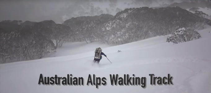
We had walked and skied the AAWT before but the 2018 trip was to be our hardest yet.
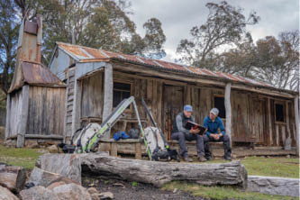
Kosciuszko cornices, day 27 All pictures by Mark Oates

Australian Alps Walking Track Winter 2018
Mark Oates

12 | BWA October 2019
AAWT Winter Traverse video
Previous AWT and AAWT tripsMy twin brother Andy and I were at high school in the late 1980s when I first learned of the Alpine Walking Track. We were intrigued and inspired by John Siseman’s guidebook and version of the “Alpine Track” that saw it unofficially go all the way through to Tharwa near Canberra rather than to its official finish point of Tom Groggin on the Victoria-NSW border west of Thredbo. Around that time we also discovered cross-country skiing, snow camping and ski touring so we soon formed the ambitious dream of some day completing the entire track in winter. First though we decided we should walk it in summer.
So it was in the summer of 1990-91 that Andy and I walked from Walhalla through to Canberra in 57 days. We were 18 years-of-age and only one week out of high school so it was a significant and life-changing experience for both of us. This was in the days before mobile phones, GPSs, PLBs or satellite phones so help was three day's walk away rather than simply a phone call or button click away as it is today. Despite or perhaps because of our age we prepared hard for the eight week journey, spending lots of time learning navigation and undertaking a remote area first-aid course. Back then our communication system was to carry a couple of stamped envelopes to give to other walkers or to passing motorists so that we could get messages through to our parents. It is such a different world today as on this trip we could post daily updates of our challenges on social media.
Soon after our summer escapade the Alpine Walking Track was officially extended to become the 660 kilometre tri-state Australian Alps Walking Track (AAWT). It was fifteen years after we first walked it before we finally found the confidence in our skills and experience plus the drive and time to attempt a winter traverse. It was a daunting proposition as at that stage we did not know of anyone completing it to Tharwa in winter (even though Craig McVeigh had in 1997). It was a trip that we obsessed and prepared for over the year and a half leading up to the journey. Our 2005 winter adventure saw us leaving Tharwa in mid-June and finishing at Walhalla in early August, 43 days later.
Then last winter, at the start of August 2018, Andy and I again set out again to undertake another AAWT traverse but this time from south to north. Despite having completed the track twice this was to be our hardest journey. We had less time available for this traverse and feared that at 46 years-of-age we might struggle with the allowed timeframe. Our plan was to travel with much lighter gear as we hoped that this would see us, despite our increased age, travelling faster and achieving greater distances each day than the 18 kilometres we had averaged last time. With Andy's limited leave from work, time soon become our enemy and for a while it was a race to see if we could finish prior to our six week cut-off date.
Older but perhaps wiser, the question was, could we do it again?
BWA October 2019 | 13


Mark making a solid liner to go over the bottom half of the mesh inner
Preparation, all gear, food cache locationsFor us it was a solid 18 month commitment to undertake another AAWT winter traverse. First, time off work and away from family needed to be arranged. Then new gear needed to be researched, purchased, tested and modified. Lists, lists and more lists had to be prepared and worked through. Discussions and decisions on what not to take become just as important as what to take. Time for physical fitness and mental preparation needed to somehow be made although this was often the area that got sacrificed due to normal work and family commitments. Meals had to be purchased or made and then dehydrated. Older gear required checking and sometimes refurbishment. New maps and GPS data had to be sourced and sorted. Food and gear caches needed to be planned, prepared and then dropped – some of them prior to the seasonal closing of access roads. Others were dropped in the week prior to our departure.
While half our evening meals were commercial dehydrated or freeze-dried meals the other half had to be cooked, dehydrated at home and packaged. Our aim was to allow approximately 800 grams of food per day per person but in the end we averaged around 900 grams. This was definitely more than we took in 2005 when Andy lost 13 kilograms by
the time we finished while I had lost at least seven kilograms. For both winter traverses our meals and snacks were not exciting nor even delicious. We simply saw food as fuel and went for items that would be efficient to cook and eat so as to minimise camp time and maximise travel time. For the first two weeks with tough track conditions and then later when we needed to make up time with 30 plus kilometre days, this fuel was absolutely vital. On both trips we regularly experienced 12 to 13 hour days with few, if any, seated breaks. Lunch often had to be eaten on the move.
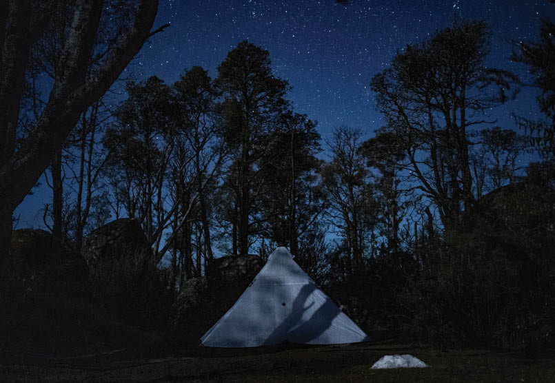
I was fortunate to have the two weeks off work prior to our departure and I think that this time was crucial to our success. I initially spent time cooking and dehydrating but also modifying gear while the last five days was spent with Andy doing our final packing and preparations. We had debated long and hard about what tent to take with the ultimate decision to use my Hyperlite Mountain Gear Ultamid for the majority of the trip and my brother’s Wilderness Equipment Second Arrow for the more exposed Main Range section. This saw me having to design and sew a solid inner for my mid rather than go with the mesh inner that it came with. In the past we have also greatly benefited from wearing Berghaus Yeti gaiters in the snow but the new versions no longer fitted the lighter
14 | BWA October 2019

weight boots that we wanted to take on this trip. Thus I ended up making us each a pair of homemade Yeti gaiters on my sewing machine. As always, tasks like these and the many other modifications that I wanted to do took much longer than anticipated. I actually spent the entire night before I flew out of Hobart sewing and altering gear as I figured sleep was of secondary importance to customising our equipment. We had 17-21 kilograms plus about 3 kilograms of camera gear.
At the end of July I flew from Hobart to Andy’s home in East Gippsland, Victoria, to spend a couple of days together on final equipment and food preparations. We then spent another two days driving 1200 kilometres to drop off our last food caches on the Benambra-Corryong Road near Omeo, at Dead Horse Gap and near Kiandra. With the help of his two kids, Andy had already dropped off food caches near Mount Skene and at Macalister Springs near Mount Howitt. A sixth food cache was given to a friend to transport to Hotham and store at a lodge where he was a member. For me, these periods immediately prior to departure on a major trip always feel chaotic and rushed but from talking to others who do similar trips this seems to be a common theme.
The trip at a glanceOur plan was to start on 1 August with exactly six weeks being available to us from then. As always, final preparations took longer than expected and so it was two days later that we departed. We chose this time period as we had previously started in late June and finished in early August and we felt that August provided the best chance of having the most skiable snow. With both of us being keen skiers it was all about maximising our ski time. Our hope was for a massive snow year and fortunately, this time we were not disappointed.
In 2005 we deliberately chose to head south as we knew that this direction provided a much easier transition into the “track” than the Victorian end. By the time you hit the harder sections in Victoria you are fit, ready and keen for the additional challenges that the southern third provides. This time we wanted to head north, as apart from being different to last time, we knew it was likely to be more challenging. Our 2018 traverse proved this to be true.
Andy and Mark at the start of the trip
“Our hope was for a massive snow year and fortunately, this time we were not disappointed.
BWA October 2019 | 15
Day
Km
Comments
1
22
Walhalla to Mushroom Rocks, Mount Erica, 1000 metres of climbing. We reached camp at 8.30 pm, 3.5 hours of walking in the dark, a common theme for this trip.
2
18
Camped near the Mount Whitelaw turnoff, with 15 or so kilometres on skis.
3
28
Jordan River valley. Lots of road walking and a waist deep cold Thomson River crossing.
4
32
Black River, 10.5 hours of walking with minimal rests, arrived just after dark. Due to wet windy snowy conditions we took the longer alternative route(s).
5
13
Ascended 700 metres battling trees collapsed by snow. Skied from the Jamieson-Licola Road but camped short of our Mount Skene food cache.
6
9
Big snowfall overnight. Due to the snow it took 2 hours and 45 minutes to find our first food cache, very lucky to do so. Camped near Peters Gorge.
7
18
Snow conditions and lots of trees on the track made for a 12 hour day. Stopped short of the summit of Mount McDonald. The weather forecast was for 80 km/hour winds.
8
13
Extremely strong winds but beautiful sunshine. Challenging snow conditions for skiing. Camped in the saddle south of Mount Clear
9
19
Mounts Clear, Magdala and Howitt, the latter in whiteout and almost on dark, Reached Vallejo Gantner Hut at 7.15 pm.
10
Rest day but skied several kilometres to collect the second food cache.
11
7
A late start from VJ Hut with challenging weather on the Crosscut Saw. This is the most difficult section of the trip to ski. Camped on the shoulder just short of the summit of Mount Speculation.
12
8
Great skiing off Speculation and over Mount Despair. Made it to Viking Saddle after 2 hours of clambering over and under many fallen trees in the dark.
13
14
Climbed The Viking in blizzard conditions then descended to Barry Saddle in the rain, walked a further 5 kilometres before camping. Falling trees a potential issue.
14
19
Skied and walked along the Barrys, climbed Selwyn and made it to Selwyn Creek Road.
15
18
Climbed The Twins in icy and windy conditions. Dangerous conditions along the road from St Bernard to Hotham so hitched. Then skied through Hotham Village to camp on the outskirts.
16
5
Mainly an organisation day – collecting food and gear cache, recharging batteries, drying gear and having ski boots re-shaped. Left village at 5.30 pm to ski out to Derrick Hut in the dark. Heard of the death of our cousin and that we would need to go back to Melbourne for funeral, date to be fixed.
17
13
Descended on skis to Dibbins Hut, which had 75 centimetres of snow. Ascended onto the Bogong High Plains to camp 1 kilometre from Cope Saddle.
18
18
Falls Creek via Pretty Valley and Ruined Castle. Left Windy Corner at 3.20 pm to ski out to Edmonsons Hut.
19
13
Nelses then opted to ski via Timms Spur and descend 940 metres to cross Big River, then a 600 metre ascent on Quartz Ridge. Camped at the treeline.
20
26
Crossed the summit of Mount Bogong and descended to Cleve Cole Hut then Long Spur and finally Big River Saddle.
16 | BWA October 2019
Lightweight alpine touring bindings
Day
Km
Comments
21
16
Mount Wills, Omeo Highway to Gill Creek.
22
22
Passed Taylors Crossing and camped at Morass Creek
23
27
A waist-deep crossing of Morass Creek, food cache #4. Decided to go fast,120 kilometres in four days, so that time off could be taken for family funeral. Left Johnnies Top at 4.30 pm. Buenba Creek Hut at 9.30 pm, 13.5 hours of travel.
24
31
Dead Horse and Limestone Creeks and camped near Marble Quarry on Stony Creek. A 14 hour day.
25
34
Cowombat Flat and onto Tin Mine Huts.
26
25
Cascade Hut, Alpine Way, and food cache #5. Then picked up to travel to Melbourne for the funeral. A few days in Melbourne, then back to Thredbo.
27
16
After camping at Dead Horse Gap, skied up to Rams Head, over Kosciuszko to camp overlooking The Sentinel and Watsons Crags. Fine weather but icy.
28
28
Twynam, Rolling Ground, Whites River Hut and on to stay at Valentine Hut
29
22
Skied directly to the summit of Mount Jagungal and from there off-track to Mackays Hut, which we reached on dark. Superb skiing off Jagungal and nearby!
30
23
Patchy snow in places so some walking amongst the skiing. Camped on top of Mount Tabletop. A windy night.
31
23
Rain! Skied to Four Mile Hut where we hid from the downpour for an hour. Side-trip to Selwyn ski resort for a coffee. Then skied to Kiandra where the decent snow stopped. Recovered final food cache #6. Camped Chance Creek.
32
32
Heavy rain all night. Witzes Hut and a waist-deep crossing of the Tantangara Creek. The Murrumbidgee was too fast and too deep, so there was a long detour to the bitumen, arriving at Ghost Gully at 9.15 pm.
33
34
Oldfields Hut, Murray Gap camp, side-trip on skis to Bimberi Peak with ski descent in the dark.
34
31
Cotter and Orroral Rivers to camp at Honeysuckle Creek.
35
16
Tharwa, protracted stay at the Visitor Centre where Andy’s car had been left. Then drove to Canberra and Kiandra to collect our food dump before returning to East Gippsland. Mark flew home to Hobart the following day.
BWA October 2019 | 17
I have selected the highlights and lowlights of a few typical days, starting with … the start.
Day 1 – Walhalla to Mushroom RocksFinally the day had arrived! As with all major trips we would have loved more preparation time but in the end we simply had to commit and go. Our parents kindly drove us to the beautiful historic gold mining town of Walhalla, nestled at the base of the Baw Baw Plateau. It really is a fantastic place to start or finish a trip such as the AAWT. After playing too much with recording footage on my new Sony mirrorless A7iii camera and eating delicious home cooked food, it was after midday by the time we eventually started walking. We departed Walhalla and headed along the route of the old timber tramway to cross the Thomson River on the historic Poverty Point Bridge. This steel bridge was originally built in 1900 to serve the Long Tunnel Gold Mining Company mine in Walhalla during the town’s gold rush.
From there it was 1000 metres of ascending up scrubby tracks to our intended campsite at Mushroom Rocks below Mount Erica.
The weather started great but turned to rain from 4 pm. Given our noon start, the climb and 23 kilometres to walk, we didn’t get into camp until 8.30 pm. With our keenness for winter trips, walking or skiing in the dark was something that we were well accustomed to. And once again this became the norm for this trip with our first day involving almost 3.5 hours of it. Despite the long day and the sore muscles it was worth it as Mushroom Rocks was a beautiful place to camp, particularly when the weather cleared and the stars came out.
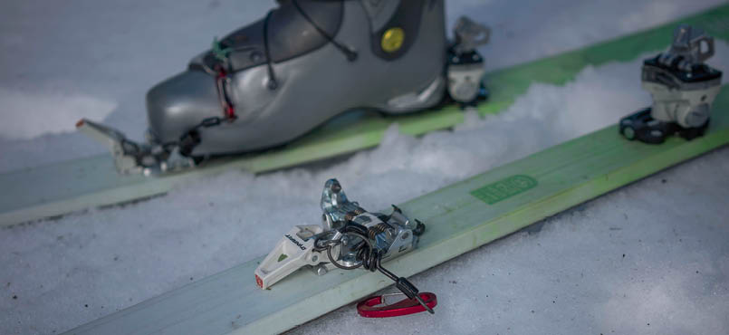
Day 2 – to near Mount WhitelawAfter a small climb up Mount Erica we spent the day skiing almost the length of the Baw Baw Plateau. We saw a few other skiers out on cross-country gear near the Rock Shelter and enjoyed the great snow cover. Normally we would also be on XC-Telemark gear but despite 30 years of experience with it, for this trip we had alpine touring (AT) gear, lightweight alpine touring bindings (Dynafit Speed Radical and Speed Turn 2.0).
Our mid on the first night, surrounded by granite boulders and myrtle beech at Mushroom Rocks
“Despite the long day and the sore muscles it was worth it ...
18 | BWA October 2019


We had riskily chosen AT over XC-Telemark despite having spent only a limited time skiing on AT gear. In fact both Andy and I had only managed to get out for a few days prior to this trip on our very new AT setups. I would not normally recommend anyone start such a major trip with relatively untested gear, however, I was confident that our system would work as well, if not better than our previous system. We chose AT gear because it was 2.8 kilograms lighter than XC-Telemark and because we believed it would potentially be more efficient. Although I absolutely loved my new setup Andy wasn't at this stage fully convinced as his default turn is a telemark turn whereas these days my default is a parallel turn. We loved the toe tech system but almost never locked our heels in.
Firm conditions initially made for good travel and we had great fun slaloming through the snow gums as we headed north. The snow line was at 1350 metres however some areas in southern Baw Baw still had minimal snow cover requiring a short walk between skiable sections. Fortunately there was an excellent cover north of the Rock Shelter where we stopped for lunch. We ended up camped 600 metres north of the Mount Whitelaw turnoff after travelling 18 kilometres with happily at least 15 kilometres of these on skis.
Although the weather was mostly great for the first three days conditions over the next 10 days definitely deteriorated. It was tough going with heavy snowfalls and a huge amount of timber lying over the track,
creating tediously slow progress. Several times we could only move at 600 metres an hour as we clambered up and over or crawled awkwardly underneath the hundreds of fallen or low hanging trees. Most days saw us travelling the last few kilometres under torchlight and it was a rare novelty to start pitching our tent before dark.
Day 6 – Searching for our food cache at Mount SkeneBy the time we arrived at Mount Skene where Andy had hidden our first food cache there was five feet of snow on the ground. Despite having the apparent GPS coordinates we simply could not find where he had hidden it. We moved many cubic metres of snow and were almost at the point of giving up after a couple of hours of fruitless searching and a huge amount of digging. This was an incredibly stressful few hours for us, as we figured not finding it might cost us the chance to make it all the way to Tharwa. With our 6-week window every day was vital and losing 3-5 days to exit towards Jamieson and somehow obtain additional food would likely have cost us the trip.
Miraculously I somehow by chance spotted the small piece of ribbon that Andy had placed at head height (and now at ankle height) when he dropped off the cache. It was perhaps 30 metres from the GPS coordinates we had and with so much snow and thick vegetation we were lucky to find it. From this experience we learned several valuable lessons.
Andy skiing to Low Saddle, day 6
BWA October 2019 | 19


Day 11 – Mac Springs to SpeculationWe crossed Mount Howitt in terrible conditions in the dark on day nine and then took a rest day on day 10 at the awesome Vallejo Gantner Hut. This gave us a chance to ski out a further two kilometres and collect our second food cache (buried this time under four feet of snow) and to dry all our gear including our boots prior to attempting the challenging Crosscut Saw.
From my perspective the Crosscut Saw traverse when it is under heavy snow (or ice as it can be) is one of the most technical sections of the AAWT in winter. The consequences of taking a slide while skiing or walking across it would be dire. Although the Main Range in NSW can be icy and battered by 100+ km/h winds you are never forced to ski directly above cliffs as there is always an easier route (however long) around the trickier sections. For the Crosscut there is no real option but to cross it and traverse its narrow spine, which at times is only a few metres wide.
To make matters worse there were a number of avalanche warnings out for the Victorian Alps exactly when we intended to cross it, along with a forecast for some strong winds!
In places the narrow ridge of the Crosscut Saw between Mount Howitt and Mount Speculation has cliffs and bluffs on one side
and steep slopes the other side. With the predominant wind hitting the ridge from the west, the east side can have large cornices and there is some definite potential for avalanches. It can also often be incredibly icy in places, particularly through the numerous wind-scoured saddles. We were really hoping for good weather for this section!
Andy and I were happy to wait out a number of days at Vallejo Gantner Hut for a good weather window even though we couldn't really afford the time. However, the forecast showed no ideal conditions within the next week. While the forecast for the following day looked like the best time to cross there was no guarantee it was going to be better. So we packed ready to go and hung around at the hut most of the morning hoping that the sun might eventually manage to burn off the thick cloud and also that the wind might dissipate. Unfortunately, neither happened but we decided to depart regardless, to at least have a look at the start of the ridge before committing to the full traverse.
We headed off relatively late at 11.40 am with the option of returning if we felt unsafe. Conditions were not ideal with very limited visibility, sleet (and sometimes hail), wet snow underfoot plus 45+ km/h winds. Luckily though it wasn’t icy so we did not need to use the ice axes and ski crampons that we were carrying after collecting them from our
Andy on one of the final "teeth" of the Crosscut Saw under heavy snow conditions, day 11
20 | BWA October 2019

Macalister Springs food and gear cache. Most of the day we managed to stay on skis although a few times we had to remove our skis and kick steps due to the steepness and the fact that we wanted to stay on the ridge rather than traverse the potentially avalanche prone slopes. It was certainly a challenging and adventurous ski but one that we still felt comfortable with. We were fortunate in that just as we were finishing the final critical section the weather improved and even cleared ahead of us.
It was great to be able to look forward and see Mount Speculation and the next day’s route along the Razor towards the Viking. While it was disappointing to not have any views of Mount Howitt and the southern end of the Crosscut on this trip we were happy to have crossed safely without incident. Thus just on twilight we happily ended up in the comfort of our tent slightly short of the summit of Mount Speculation. It was definitely a relief to have this difficult section out of the way.
Day 12 – Speculation to Viking SaddleWe hoped to wake to fine weather and magnificent views but it was not to be. We slowly traversed towards the summit of Mount Speculation, or “Spec” as it is affectionately known, trying to delay our progress in order to capture some views. On a clear day the views of the cliffs and steep slopes below plus those of the Crosscut and Howitt are spectacular. Spec also commands tantalising but distant views of Hotham, Feathertop and Bogong. Occasionally the sun managed to somehow get through the persistent cloud but the views were always fleeting and promised more than they delivered.
It was a fun ski down from the summit to the treeline and it was great to throw some actual turns down for a change rather than simply use survival skiing techniques. We skied all the way to Catherine Saddle, carefully but awkwardly stepping over rocks, dirt and fallen trees still with our skis on before continuing up onto Mount Despair on them.
Andy on The Razor, day 12
BWA October 2019 | 21

Our assumption was that the track would be poorly marked and poorly defined, so we made our own way directly straight up the side of the mountain. Our mistake, as when we got to the top we found a well-marked track that we should have followed from the start in the saddle as it might have saved us considerable pain and frustration.
The skiing across Despair was great but on the descent towards The Razor it was again time to start carrying our skis. This time we were impressed with the track as it appeared much more defined than when we last crossed it in winter. Thankfully we only struggled to follow it a couple of times and this was simply due to the 30 centimetres of snow on top of the route. With some reasonable weather we were enjoying ourselves. That is up until the descent into Viking Saddle. It started well and we excitedly put our skis on before having to remove them a hundred metres later. By this time it was getting dark but we were still in a happy place as we only had 1.2 kilometres to go. However, the state of the track soon changed our demeanour. With major trees down every few metres it took us almost two hours in the dark to travel little more than a kilometre to get to the Viking Saddle. It was a relief to finally get there!
Day 13 – Viking Saddle, the VikingDay 13 was a decidedly unpleasant experience! We woke to a wonderful sunrise and an amazing view of The Viking above us. Looking into the forested section ahead it didn’t even look that bad, certainly nothing like the horror of the final two hours we completed in the dark the previous night.
The beautiful start to the day evaporated at 7.45 am when we got hit with what were essentially blizzard conditions. Suddenly the sky darkened, the wind picked up and started plastering everything in large wet snow flakes. The annoying part was that we were almost packed up but not quite.
With heads down we set off for The Viking and although steep it was not too bad. The weather was wild and seemed to increase in intensity the higher we got. Eventually we made it to The Viking chimney and although there are better routes that avoid it, all the rock was caked in snow, making route finding and scrambling very awkward and incredibly slippery. We briefly sheltered inside the cavern at the base of the chimney then struggled awkwardly up it. Unfortunately I took the least ideal route from there making for some challenging and potentially risky climbing moves as I scrambled to find a safe route to the top.
Andy at Viking Saddle shortly prior to blizzard conditions enveloping the area, day 13
22 | BWA October 2019


On The Viking we were initially in waist deep snow. We could have skied across it however it was too difficult to transition into ski boots from hiking boots in the blizzard conditions and we knew we would have to descend pretty soon anyway. We managed to find the descent track and were impressed with the amount of markers and work completed by parks track crews. By 2.30 pm we staggered into Barry Saddle although we knew we were at least a day behind our planned schedule so we quickly continued on. The track started well then deteriorated with more fallen trees and overhanging bushes. Combined with the steady rain we were soon soaked from pushing hard through all the wet bushes.
With the high winds and fresh trees down everywhere we were really worried about trees falling on our camp so for once we started looking for suitable sites early. Over the past two weeks we had heard numerous trees fall, more than we had ever previously experienced. We initially went past a pretty safe spot hoping to cover greater distance but soon the track deteriorated even further with no signs of a possible clearing so we back-tracked to it and made camp. With the AAWT route being along a ridge we had no easy access to water but we were able to leave some containers at the base of a large mountain ash and they soon filled from the rainwater pouring down its trunk. It was a relief to get into the tent and get into dry clothes and to warm ourselves as we were exhausted.
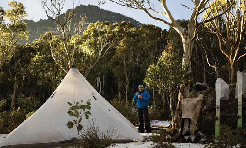
Day 18 – Near pole 267, Falls Creek, Edmonsons Hut We woke to a beautiful day and soon had sunshine warming and drying the tent. The latter was an amazing feeling and not one that we had experienced on this trip.
For this section from Hotham to Falls Creek we were trialling Andy's new mountaineering tent for two nights. I absolutely love my Hyperlite Mountain Gear Ultamid tent; in fact it is probably my favourite bit of kit along with my packraft and skis. However, as good as it is, Andy kept reminding me before the trip that as good as pyramid tents are, they are not four-season rated and are not designed for 100 km/h winds. So the plan was that if Andy's Wilderness Equipment Second Arrow went okay for us for these couple of nights we would take it on the extremely exposed sections above the treeline along the Main Range. Theoretically its low profile would be able to handle the ridiculously strong winds that the NSW alpine environment was notorious for. It was interesting along the journey to see Andy's reaction to my pyramid tent as he had rarely used one prior to this trip. By the end of the AAWT he was in agreement at just how good they are (in the right situation). That said, pyramid tents need to be used with care and lots of thought on campsite selection, particularly in alpine environments.
By surprise, at Falls Creek we met one of our great friends, Bernie Mills. Andy, Mark and Bernie, day 18
“... its low profile would be able to handle the ridiculously strong winds ...
BWA October 2019 | 23
We skied up Pretty Valley and from the top of Ruined Castle got a spectacular view of Mount Bogong, where we hoped to be the following night. It was a joy to briefly get on the groomed runs and race down into the village in order to find a new telescopic pole for me. This was because I had broken one the day prior when I unexpectedly dropped one and a half metres off a hidden cornice just after the sun set. We were also there to collect a couple of packages from the post office. It would have been nice to be on patternless skis but our Voile Objective pattern-based touring skis handled the high-speed run down the groomed trails extremely well. Despite being a light ski they excel on the descents and in challenging terrain such as heavily forested slopes. We absolutely loved using them on this trip. Although many others have said that they would use a traditional long narrow touring ski for winter AAWT trips, our preference is for a short wide and light agile ski like the Objective BC.
It was 3.20 pm by the time we left the very busy Windy Corner but we were able to move along the groomed cross-country Hoppet ski trail at over 5 km/h, our fastest average speed to date on this trip. Thus we arrived at Edmonsons Hut and set up the
Ultamid before it got dark. Amazing! Then I discovered that a ski party at the hut were from Tassie so had a great chat with them. It was cool to think that this was the same spot where Andy and I undertook our very first snow camp, 30 years ago when we were 16 years old.
Day 19 – Crossing from the Bogong High Plains to Mount BogongWe left Edmonsons and headed up above the treeline onto the shoulder of Mount Nelse. This is an incredibly exposed section where we experienced very strong winds. The sun was trying to poke through which did create some beautiful effects, however, it wasn’t having any real success. The snow was very firm, with windpack and some ice. This was actually great for us as it made for fast ski travel. We soon left the main Hotham-Bogong pole line and instead headed out to Timms Spur so that we could descend to cross the headwaters of Big River and then ascend Mount Bogong via Quartz Ridge. In my opinion this is a much better way for those on skis than to descend Duane Spur and ascend T-Spur and have to do a side trip to summit Mount Bogong. Quartz Ridge, although a lot more exposed than the alternative, offers amazing scenery

Andy crossing Big River, day 19
24 | BWA October 2019


and an incredible alpine atmosphere unlike the route from Ropers Hut which involves dealing with a lot of scrub and wet bushes plus the potential of higher water flows on the river crossing due to being further downstream.
Unfortunately, visibility was poor which was a shame as normally the views from Timms Lookout of Cairn Gully, Quartz Ridge and West Peak are magnificent. It was cool though to check out, from a safe distance, the huge cornice that was there. The 600 metre descent was tedious as the snow was quite slow and sluggish once we hit the tree-line. By the time we got down to Big River it was sleeting rather than snowing making for a very chilly and damp lunch and for a cold river crossing. Later on in the trip we would again cross this river but further downstream where its name changes from Big River to the Mitta Mitta River.
Fortunately the snow was much better on the Quartz Ridge ascent. It was great to get to our intended camp spot at the edge of the treeline with just enough time to dig a large shelf into the slope and get the mid up before dark.
Day 20 – Mount Bogong to Big River SaddleFinally we got lucky with the weather, views and our timing matching up! After light snowfalls throughout the night I wasn’t expecting to wake to fine weather although I had been really hoping for it. I felt as though we had missed out on showcasing much of Victoria’s amazing alpine environments because of the poor weather we had experienced for a lot of the first two weeks. So to wake to mostly clear skies, with clouds in the valleys below us, was incredible. I took hundreds of photos resulting in us not leaving camp till much later than normal. We also spent considerable time filming the final climb up Quartz Ridge, further contributing to our delay. It was worth it though as views such as these were the reason we were doing the trip.
There were quite a few smallish cornices on the ascent and I managed to get too close to one while trying to get the right angle for a shot. Suddenly there was a “woomph” sound as the snow dropped out from under me. Fortunately I only dropped two metres while the main cornice section (an area about five
Camp at the Quartz Ridge treeline, day 20
BWA October 2019 | 25
metres wide) rolled another 10 metres down the hill. No harm done but it was a good reminder for me about being too complacent in an environment such as this.
We ascended to the 1986 metre summit of Victoria’s highest peak and took the obligatory photos of us and the summit cairn then started our traverse and fun ski descent out to Cleve Cole Hut. Conditions were firm but not as icy as the day prior so we made good time and got some fun turns in on the final descent. This hut is probably the best public accessible hut in Victoria, so we spent way too much time enjoying its comforts. It was after 2 pm by the time we departed and we were still keen on achieving another 16 kilometres as we hoped to try to get to Mount Wills.
After bumping into a couple of solo skiers we skied down Long Spur but as the name implies it is a long way and eventually darkness descended. An hour into the night, after walking off and on snow in our ski boots for the last two kilometres we finally made it to Big River Saddle. Although several kilometres short of our ambitious goal of Mount Wills we were happy to make the saddle and to actually camp off snow for a change.
Day 26 – Tin Mine Huts, Dead Horse Gap and MelbournePrior to reaching Dead Horse Gap we learned that a close relative had lost his life and that a funeral would be held in the following week. So we pushed hard from the Benambra-Corryong Road with several 30 kilometre days. This enabled us to get to Dead Horse Gap early and get collected thanks to another family member. Next morning we caught an early train to Melbourne for the funeral. A couple of days later we made our back to Thredbo via bus and walked up towards Dead Horse Gap.

Quartz Ridge treeline camp with Timms Spur andthe Bogong High Plains behind, day 20

Andy and Mark at Cascade Hut, day 26
26 | BWA October 2019


Day 27 – The Main RangeWe climbed out of the Thredbo valley on skis to a glorious sunny day. It was a joy to emerge from the tree-line and to then crest the main ridge near the Rams Head. From there we skied down into the headwaters of the Swampy Plain River just south of Lake Cootapatamba so that we could head directly up towards the summit of Australia’s highest peak, Mount Kosciuszko, at 2228 metres. In good weather conditions, the next couple of days are the most spectacular part of the Australian Alps and the AAWT. At times we could see the highly prominent Mount Jagungal jutting out in the distance and it looked like a great cover of snow extended all the way there. We were super excited and thankful to have such good views and such a great snow cover.
As Andy had to be back at work in another 11 days our schedule for this section and final third of the AAWT was still incredibly tight. With 200+ kilometres still to go we were really hoping that conditions would allow us to tour decent distances each day. If not we would not have time to complete the full traverse from Walhalla to Canberra.
We finished the day camped above extremely steep icy slopes overlooking The Sentinel and Watsons Crags. It was an incredibly beautiful outlook and sunset and we were so happy to be there. The next day would see us travelling across the Rolling Ground and down to Whites River Hut and then beyond to stay at the homely Valentines Hut.
Day 33 – Climbing Bimberi PeakDespite the day prior finishing at 9.15 pm after a very long 32 kilometres, we got away early and set ourselves an ambitious goal
of getting to and climbing the Australian Capital Territory’s highest peak. We saw lots of brumbies out and the walking was straightforward and relatively easy. After 20 kilometres we stopped for lunch near Pocket Saddle at 12.15 pm, our earliest lunch yet. We then set off for beautiful Oldfields Hut and then onto Murray Gap, another 8 kilometres away, where we planned to camp. We met a group of three young guys who were similarly ambitious with a huge day trip from the other side of Murray Gap to Blue Waterholes and back.
It was almost 4.30 pm by the time we had set up our tent and departed Murray Gap for an evening ascent of Bimberi Peak. The guidebook suggested three hours for the 6 kilometres return trip and the 400 metre ascent but we only had two hours of light remaining. So we were expecting a slight challenge. We weren’t disappointed.
After walking for 750 metres it was time to put skis on and outfit them with our kicker skins. We almost always carry these short lightweight skins with us when touring with
Ascending towards the Rams Head out of Dead Horse Gap, day 27
Andy and Mark at Oldfields Hut checking the logbook, day 33
BWA October 2019 | 27

a pack as they have proved advantageous innumerable times. The climb was arduous due to tough conditions with only 30-40 centimetres of snow and lots of trees and scrub to get around. We really wanted to make it the summit in time to capture the sunset so pushed hard. We almost made it but not quite, missing it by 5-10 minutes.
The ski back under torchlight was hairy and definitely a real challenge but was also great fun. Surprisingly, we managed to ski in the dark through all the trees and scrub and almost all the way back to the very edge of the snowline. In the end the guidebook was spot on for the time it took us. If we hadn’t carried our skis from Kiandra though we suspect it would have taken us twice this time. So from Andy’s and my perspective this short but fun ski made it worth carrying our skis on our packs for the additional 105 kilometres. Understandably I cannot imagine any of my ski-touring friends agreeing with this perspective.
Days 34 & 35 – Finishing the AAWTAt this stage we finally knew that barring an incident we would make our end goal. Our last day and a half were about cruising and savouring our final time on the track as we travelled through Namadgi National Park towards the end of the AAWT at the Tharwa Visitor Centre. The differences in park management strategies between Kosciuszko NP and Namadgi NP were highly noticeable. While horse manure covers
much of the ground in Kosciuszko, we saw absolutely no signs of feral horses at all in Namadgi. We also went from only seeing the occasional kangaroo and wallaby south of the ACT border to walking past hundreds of kangaroos in the Orroral Valley.
We camped at Honeysuckle Creek, near the site of the former space tracking station, and the next day enjoyed the final 16 kilometres of the track down to Tharwa. Just prior to arriving we sat down and savoured the view for 40 minutes as we contemplated what we had just achieved. For much of the trip we were unsure whether we would make our cut-off date or whether we would run out of time. So it was satisfying to acknowledge that we had finally completed the 660 kilometres in five weeks despite some really challenging conditions early in the trip and the need to leave the track for a few days to attend our cousin’s funeral.

ACT sunrise from Murray Gap, day 34
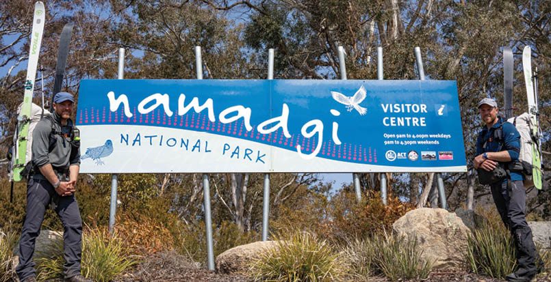
Andy and Mark in front of the Namadgi sign, day 35
28 | BWA October 2019
Our planned short stay at the excellent Namadgi National Park Visitor Centre in Tharwa (and the official conclusion of the AAWT) turned into a long stop as it was great to meet the generous rangers and to learn more about the area. Andy’s car was at the Visitor Centre so we dismissed our great intentions to stay lean and fit and headed for iced chocolates, coffee and chocolate in Canberra. Then we headed south and home via a detour to Kiandra to collect our northern-most food and gear cache. This involved torchlight crossings of fast flowing thigh-deep water across Head Creek and the Eucumbene. It was 1 am before we finally rocked up at Andy’s home in East Gippsland. The next day I flew home to be reunited with my wife Jen in Hobart. Sincere massive thanks to our wives and families for giving us the opportunity to attempt and succeed on this journey!
Reflections on the tripFor us the trip was always about being on snow and ideally skiing as much of the track as possible. We were fortunate that it was such a good snow year. Although we were off snow for much of the last 100 kilometres it still felt like a highly successful trip with our bodies holding out, our relatively lightweight gear systems working well for us and due to the fact that we actually really enjoyed the majority of the challenges and difficult weather that we faced.
Long trips such as this always teach you valuable lessons. It was great to be reminded of just how beautiful our Australian alpine and sub-alpine environments are. These days the emphasis of backcountry skiing seems to have shifted from touring on light gear towards charging super steep slopes on heavy gear but this trip showed us just how good we have it in Australia for ski touring. The combination of rolling terrain, pockets of weathered snow gums, beautiful but basic backcountry huts and unpredictable weather make for some excellent touring opportunities. I hope that our trip inspires others to explore and tour our unique alpine environments in winter whether it be on snowshoes, cross-country skis, alpine touring gear or through split-boarding or snowboarding. Because there is nothing
quite like travelling through a pristine area with 20 centimetres of fresh snow lying on the ground feeling as though you are the first person to have ever been there. Likewise, waking to sunshine, fog settled in the valleys below and a view of places like The Sentinel or Mount Bogong is an incredible experience not to be missed.
Mark
Andy
After a short career as an Outdoor Educator and sometime ski addict, Andy has been working as an Ambulance Paramedic for the last 20 years including a number of stints volunteering in Vanuatu and East Timor. He is a member of Ambulance Victoria’s Wilderness Response Paramedic program and has been heavily involved with Alpine Search and Rescue Victoria as well as a member of Bush Search and Rescue with Bushwalking Victoria for the last 15 years. Andy lives on the edge of the Gippsland Lakes in sunny Paynesville and enjoys introducing his two children to Victoria’s beautiful mountains and coast.
Mark is an Outdoor Education Teacher in Hobart who seeks to combine his own passion for outdoor adventures with that of teaching young people about the outdoors. In addition to a love of snow covered mountains Mark and his wife Jen are always keen to explore wild rivers and undertake alpine bushwalks particularly in their adopted state of Tasmania. In his non-existent spare time Mark runs courses, specialising in whitewater packrafting, for Paddle Tasmania.
A full trip report and images can be found here markoates.exposure.co/australian-alps-walking-track


BWA October 2019 | 29