


My wife and I had climbed Hannels Spur in April 2006, shortly after the 2003 fires, and we thought we would take advantage of the newly cleared track and do it, this time downwards. I don't think we found all the original track in 2006 as several sections we did then cannot be found today. This includes the gully at 1000 metres. In 2006 I think we went straight across the saddle above the gully, camping in a nice flat spot in the middle.
Distances and height changes (sum of ascent and descent) are fairly approximate. Most days were cold and windy - better than hot with march flies of course!
Coming off Carruthers heading towards Lake AlbinaAll pictures by Roger and Sue Caffin

Hannels Spur Loop, New South Wales, April 2019
Roger Caffin

6 | BWA October 2019
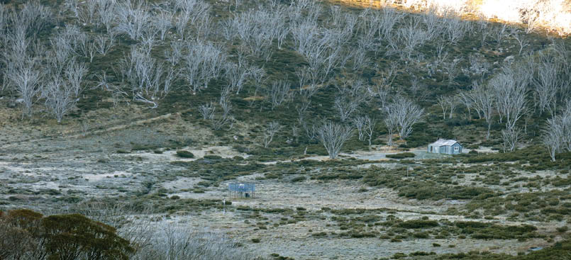

Whites River Hut in a good frost
Day 1 – Cesjacks gate to Bulls Peak, 9 km, 150 metres ascent/descentAfter driving from Sydney to Kosciuszko National Park (KNP) we started from the “Cesjacks” gate near Jagungal at 1415 and followed the old 4WD track along the Great Dividing Range to Smiths Perisher (a widely-used local name, referring to the knoll at 290957). The old 4WD track up Smiths Perisher seems lost now, so we went up at an angle to pick up the remains of the track at the top. A bit of scrub. We crossed the unnamed valley between here and the Bulls Peaks and camped in a nice spot at the top.
Day 2 – Bulls Peaks to Schlink Hilton, 18 km, 350 metresAn early breakfast and we were away heading along the Valentine valley just below the peaks. There used to be the remains of a reasonable 4WD track along here, but it was not visible today. Instead, a rather gross feature of today was a heavy smoke haze from farmers burning off outside KNP. We zipped past the Brassys at some speed.
After passing Tin Hut at a distance we made a poor tactical decision to angle up the hills (to reach the watershed) to Gungartan Pass. The scrub was very heavy, and we did not enjoy that at all. A better route would seem to be weaving through the grassy patches up the bed of the Valentine. Over Gungartan Pass we skirted hard left above the top edge of the huge scree field to hit grass on the side of the spur from Gungartan and followed that down the true left bank of what we call Schlink Hilton Creek, to the hut. It's not a
bad route. Old maps suggest there used to be a stock route from here to Schlink Pass, but we saw no signs.
The Schlink Hilton has been rearranged internally a little and it now has mattresses on some of the wire stretchers. Oh WOW!
Day 3 - Schlink Hilton to near Blue Lake, 22 km, 400 metresThe forecast for Perisher had been for overnight temperatures in the 2-3 °C range. They were not too far wrong: -1 °C actually, with serious frost. We were up at 0545 and away before 0700 for Whites River Hut - which also lives in a frost hollow! A lot of white around.
There's a mesh bridge across Munyang River now, and the 4WD track up onto the Rolling Ground is quite visible. We followed that up: it gets a bit vague and then disappears near the top, but no matter. A little bit of compass

Camp the first night near the Brassys
BWA October 2019 | 7
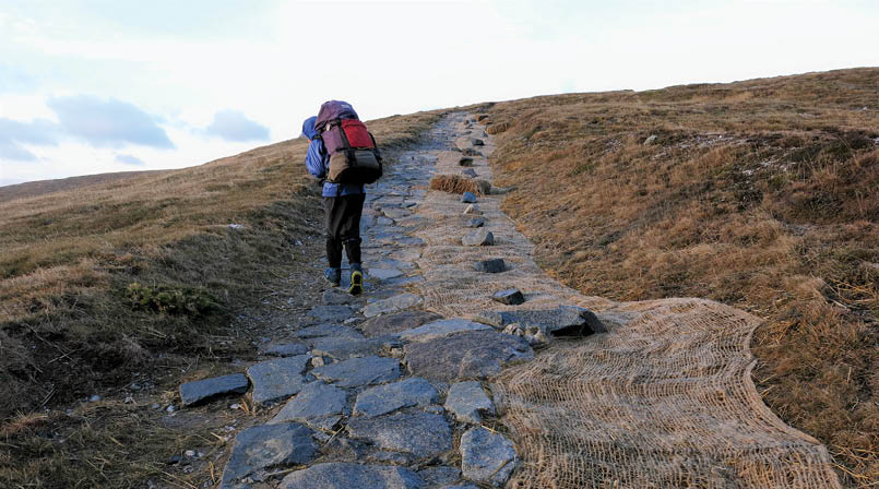
The Main Range Walk with erosion-proof paving stones
work had us at Consett Stephen Pass in short order (in fine weather). Guthega Dam below us looked a bit empty. There are even traces of a pad (or very old 4WD track) in places on the Rolling Ground, but they don't persist. In fine weather it's very nice country.
We followed the fair track (remnant 4WD in places) around the side of Tate for a while, then climbed up on top and went over Mount Tate. From here on there was a visible foot track all the way. The Feldmark above Blue Lake seems to be doing well, now that there is a visible track to stay on. A number of day walkers were headed for Mount Twynam in the cold wind.
Day 4 - near Blue Lake to Hannels Spur, 16 km, 1500 metres (mostly down) A change in the night had brought much higher levels of cold humidity with it, so we had condensation inside the tent on the windward side. Some of it dripped onto my quilt, making it look a bit wet, but the Durable Water Repellent held and I was able to mop most of it up. Another early start saw us keeping our thermal tops on for a little while.
From the saddle above Blue Lake there is now a stone-flagged path for much of the way to the summit road. This is deplored in principle but the Great Lakes Walk sees 1-2000 or more day walkers every year. What else can the NPWS do?
Now, laying all these flagstones is hard work, so the NPWS was using two Bobcats for the heavy lifting. The effect of the rocks on the rubber tracks is apparently severe, so maintenance is needed. Both machines were missing their tracks. At least they used tarps under the machines to keep the oil off the ground.
There used to be some foot-wandering across the (very rare) Feldmark patches on top of the ridge, and the damage was getting worse with the increased traffic, so today Lee and Northcote are bypassed by a rather long steel boardwalk, installed with really minimal damage to the surrounds. We could not see any damage.
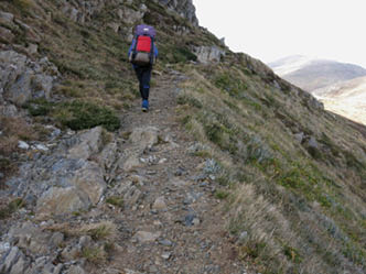
The original benched track above Lake Albina
“... long steel boardwalk, installed with really minimal damage to the surrounds.
8 | BWA October 2019
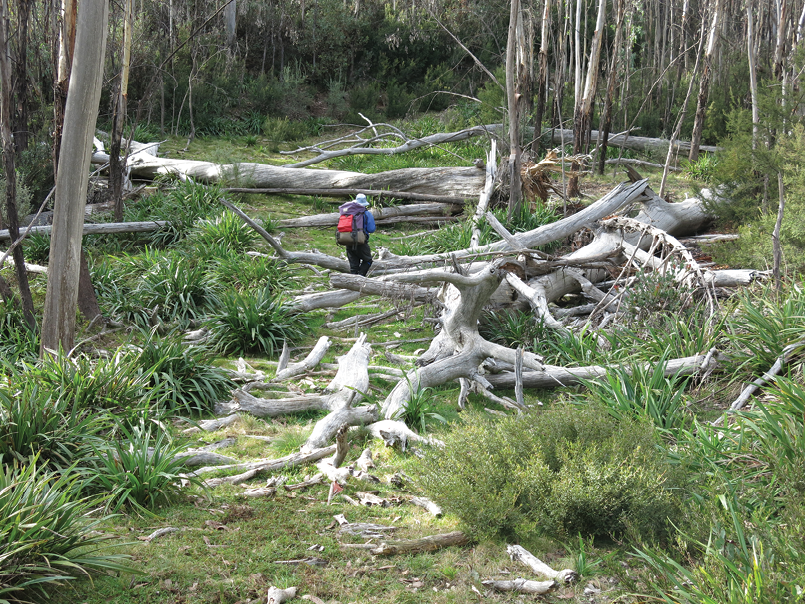

The Pinnacles Fire Trail, covered in fallen trees from the fires
Again, a steel boardwalk is to be deplored in the abstract, but the traffic levels are very high and at least the vegetation is now protected. Fortunately the interesting rocky bits above Lake Albina are, for the moment, preserved. I hope that continues. If you fall off here they might need a chopper to fish you out of the lake.
From Mueller Saddle we took the rough track to Mount Townsend to go over the top of Abbott Peaks and down to Byatts Camp. This was a really big mistake, as it took us over the granite boulders of the Western Fall. It also took us a long time to get down! But we did, picked up the cut track from Byatts Camp and followed that to the Hannels Spur signpost. The signpost does seem to be a trifle old ... especially compared to the shiny new one at the bottom.
Then down the cut track for a late lunch at Moiras Flat, picking up water at the signposted spring nearby. I can't say the Moiras Flat is all that flat: a clearing maybe. The track-work they have done is valuable, but it will need to be repeated every year or two. The dead trees are still falling.
From Moiras Flat down to the saddles around 1000 metres the track is very steep and is covered in much bark and dead leaves. Traction was very poor and I landed on my
bum several times. Sitting down did not hurt too much, but getting back up without sliding was sometimes tricky. It also took some effort. We reached the first saddle about 1630 and stopped there. It is the one before any of the bumps. My knees were a bit jelly-like at this stage. There was not a lot of room in the saddle for a tent, but we managed.
Day 5 - Hannels Spur to the Pinnacles FT, 15 km, 1500 metresThe track after the saddles is much easier - mostly. It does a lot of sidling around the steep hillside in places, which can be a bit slippery. I am sure when we came up in 2006 we missed a lot of the sidling and went straight up the crest of the spur. Anyhow,
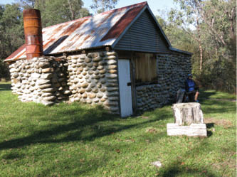
Dr Forbes Hut at the bottom of Hannels Spur, rebuilt after the fires
BWA October 2019 | 9

we eventually hit the old 4WD track at the bottom and cruised happily down to the rebuilt Dr Forbes Hut. The interior is a bit spartan - a plain concrete floor - but there is nice grass outside for camping.
We waded across the Swampy Plains River and had morning tea in the sun on the far side. Then we went up to the tarmac and
followed that over the Geehi Bridge. We could have followed the 4WD track across the grasslands from Dr Forbes and over the Geehi ford to the NPWS gate, but the Geehi is bigger. Then a road bash up the tarmac to the Geehi Dam road, and another boring six kilometres up that to the start of the Pinnacles FT. Snowy Hydro has markers at kilometre intervals up this road.
I should point out two things here. The first is that this is not a fire trail but a seriously engineered SMA road, now abandoned. The second is that for the full length of it, up to the Pinnacles, it is covered in hundreds of fallen gum trees: very large gum trees in fact. Shortly before the Pinnacles FT crosses Grassy Flat Creek (near the bottom) the hillside is covered in tree ferns: a spectacular sight.
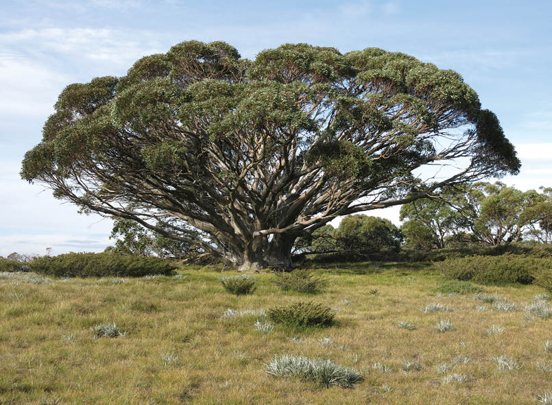
The magnificent snow gum before Grey Mare Hut, probably over 50 years old
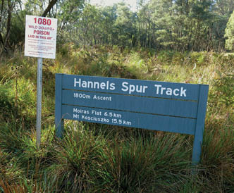
Sign at the bottom of Hannels Spur
“The “Fire Trail” remains a “road” though: it was hard getting even Ti tent pegs in place.
“... this is not a fire trail but a seriously engineered SMA road, now abandoned.
10 | BWA October 2019
Roger started bushwalking in Scouts. He is retired and still walking, generally with his wife, with trips ranging from day walks to several months at a time in Europe on alpine routes. In winter he and his wife also go cross-country ski-touring and snow shoeing. For many years he was the editor of The Bushwalker, the quarterly magazine of Bushwalking NSW, and he was an editor with BackpackGearTest. He is the author of the Australian Bushwalking FAQ web site. He is a moderator for the forums at Backpacking Light, an ultra-light bushwalking website. He lives on a farm outside Sydney.


We wandered up the track continuously stepping over and ducking under the fallen trees. The NPWS does not have the resources to clear this track, and frankly I do not want them to attempt it either. It is impassible to feral horses, ridden horses, MTBs and trail bikes, and should stay that way - please.
Yes, it really is like this for much of its length! Anyhow, we managed to find a flat grassy bit of the track to camp on. We had carried water up from Grassy Flat Creek for this. The “Fire Trail” remains a “road” though: it was hard getting Ti wire tent pegs in place. There was hard rock under the green grass.
Day 6 - The Pinnacles Fire Trail to Grey Mare Hut, 25 km, 400 metresWe blithely stepped over and ducked under trees all the way to the top of the Grey Mare Range, for morning tea. Mind you, beware of the ants at the top! From there it was a fast hoon to the north along the dry Grey Mare Range to reach the turn-off down to Grey Mare Hut. Along the way we passed a magnificent unburnt snow gum (previous page).
Grey Mare Hut is nice but is suffering from over-use. Apart from the lack of mattresses (there used to be at least one big mattresses there), the surrounds have been stripped of dead timber for quite some distance; what can be found is very old, lacks any volatiles and usually has a damp rotten core. The two saws at the hut are either very blunt or have an extremely bad set on the teeth. I found them useless.
We managed a small fire, but that was all. It was really appreciated by the solo MTB rider (legal I think) who turned up well after dark. He slurped up some energy gels or whatever and collapsed into his sleeping bag. He should have stopped earlier.
Day 7 - Grey Mare Hut to Cesjacks gate, 20 km, 250 metresUp bright and early (0545), breakfast and quietly away - leaving the bike rider snoring. North on the Grey Mare FT to the cairn for the Strawberry Hills FT. Well, we found the cairn all right (because I knew where to look
for it), but we found zero traces of the FT up the hill - and we did look. In hindsight I think we were too low. The scrub up the hillside is a very solid mass and about 1.5 metres high. Progress was extremely slow. Eventually we dropped into the creek below to get some grass - we had skied down this a number of times and hoped it might be better. It was - a bit - so we made our way to the saddle at the top for morning tea in the shelter of some bushes. It was still windy.
Anyhow, we were now on our much-loved Strawberry Hills, so we trotted across them, picking up faint traces of the old track in places. It was never a fire trail; it was a straight fencing maintenance track from the cattle days. Above the Geehi there is a prominent cairn on a boulder and some old fence posts. Last time across I found a cache of old fencing stuff somewhere near here: many bundles of star stakes, coils of #10 fencing wire, and of pig netting. Must have cost someone a bit.
We crossed the Geehi at one of the gravel banks (there may once have been some gold mining here) and headed over the ridge to McAlister Saddle, down to Doubtful Creek and back up onto the Great Dividing Range and the remains of the 4WD track there. That too is getting faint in places. We got back to the gate and car at 1600, which meant we were in time for steak and veg in Cooma.
“Mind you, beware of the ants at the top!
“... we were now on our much-loved Strawberry Hills ...
BWA October 2019 | 11