

Winburndale Nature Reserve is located in the Central West of New South Wales, between Lithgow and Bathurst, where what was once an ancient riverbed has been uplifted more than 1200 metres above sea level. This unique subalpine environment, set among surrounding plains, provides a refuge for many rare and unique species. The area also contains cultural sites belonging to the Wiradjuri traditional owners.
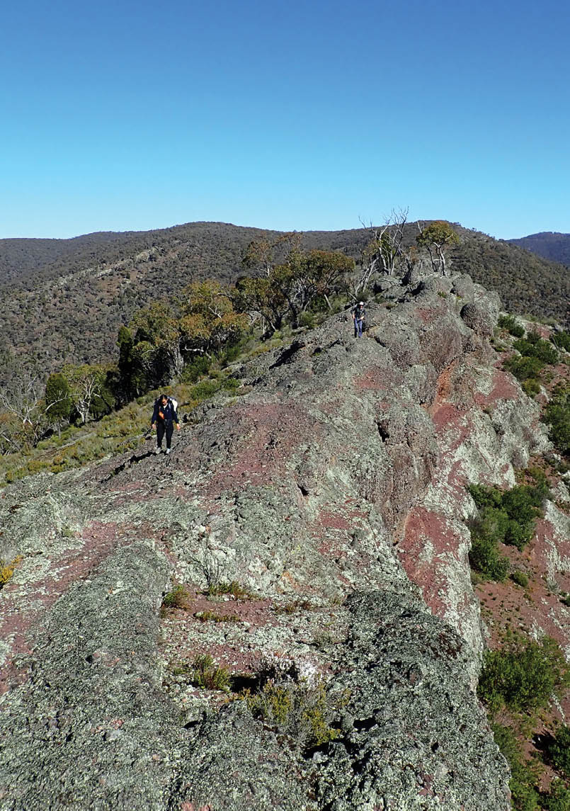
Jacqualine and Kosta walk along the escarpment above Middle Arm CreekAll pictures by Tim Volmer

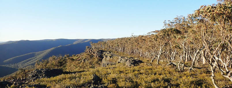
Traversing the Winburndale Range
Tim aka Fat Canyoner

6 | BWA October 2020
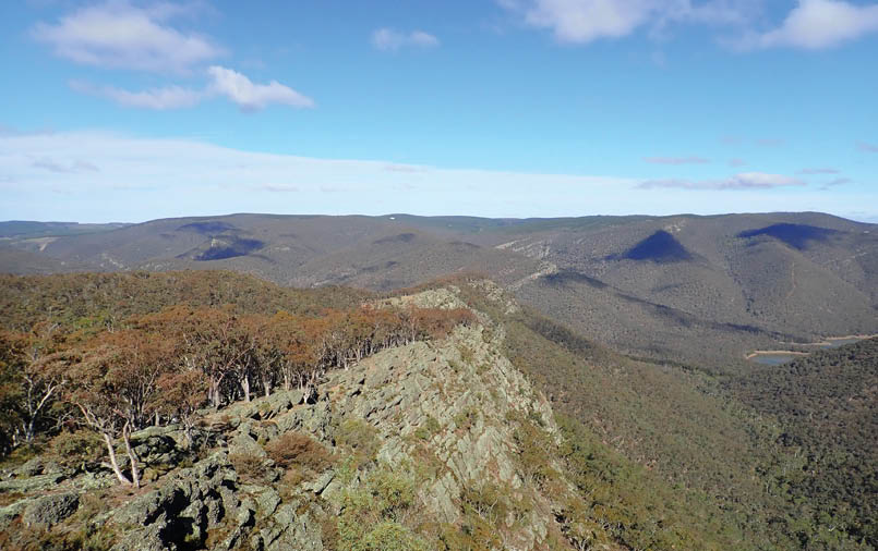

Looking south along the escarpment towards our starting point, with Winburndale Dam to the right
Crazy at it sounds, living at the base of the World Heritage-listed Blue Mountains can be a bit of a curse. Having so many spectacular natural places to explore, right on my doorstep, I often fail to make time for places that are a little further afield. This walk was part of my effort to rectify that.
The Winburndale Range, with its series of impressive escarpments running in an almost perfectly straight line, grabbed my attention while trawling satellite images looking for bushwalk inspiration. The fact that I’d never even heard of this place — despite it being located just over the Great Dividing Range — only piqued my interest more.
A little research revealed a unique place full of contradictions: a mountain range topped with river stones; sub-alpine forests perched among the dry plains of the central west; and a row of conglomerate cliffs bursting out of the earth at a 45 degree angle.
Much of the range falls within Winburndale Nature Reserve. Because the primary aim of the park is the protection of diverse flora and fauna, rather than human recreation, there is very little promotion of the area, with low impact activities like bushwalking all that is allowed.
My plan was to traverse as much of the rocky escarpments as possible, including what looked like an impressive knife-edge ridge. I also wanted to check out a couple of interesting creeks as they carved deep chasms through the range.
Making the planned route work required a pretty intense car shuffle, but it seemed the best way of fitting everything into a winter weekend.
A shortage of vehicles nearly scuppered our plans until Bron generously let us borrow her car for the weekend, although if she’d known the beating we were going to give it she may not have been so kind!
Our original plan was to drive out on Friday night and camp where we’d be leaving one of the cars, but with rain rolling through the mountains we decided to stay warm and dry at my place before leaving early the next morning.
As we bounced our way along the maze of rough dirt roads and sailed through some pretty impressive muddy pools, we were very happy with the decision to avoid a wet and chilly night.
BWA October 2020 | 7
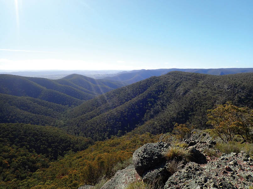
Looking across Dry Arm Creek from near Big Flat
After one of these pools the smell of burning rubber forced us to pull over. Our amateur mechanic skills were put to the test, but we quickly confirmed that while we’d lost a fan belt, it was only the one for the air conditioner, so it wouldn’t impact the trip. With the first car left in position we made our way back out of the forest and headed south.
Gulf Stream to North SpurOur chosen route to the start of the walk - which looked like a shortcut on the map - ended up involving a particularly rough track through a pine plantation.
It was mid-morning by the time we set off down a maintenance trail. I’d told everyone to pack light, but we were all lugging a fair amount of water given the ongoing drought.
Before long I diverted the group into the bush in search of a little waterfall in Gulf Stream. We quickly reached a small cliff which took us down to the creek. It was flowing well due to the rain the night before, making my insistence that everyone pack plenty of water seem like overkill.
We headed back to a fire trail for a bit, but couldn’t help commenting that the off track walking so far had been an absolute pleasure through beautiful open bushland. We all crossed our fingers that it’d continue like this.
Before long we headed off track again, following the first of our impressive rocky escarpments. Below us, Winburndale Dam was looking a dry and depressing sight. Ahead we could see the ridge we were heading towards, which promised an unrelenting ascent. The wind was gusting, but the clouds that had remained from overnight were now starting to break up, with growing patches of blue promising a beautiful day ahead.
We headed down into Winburndale Rivulet where we were welcomed by an impressive valley shaded by towering casuarinas. After a quick pause to enjoy the scenery and drink from the gurgling brook we set off up the ridge. Despite the steep terrain, the open bush made for pleasant if somewhat sweaty progress.
8 | BWA October 2020

Kosta clambering along the knife-edge ridge north of Clear Creek
The climb ended suddenly, bringing us to the top of a lovely ridge. The stunning ridge with towering cliffs was everything I’d hoped for and more. I noticed my cheeks were starting to feel a little sore. It took a moment to realise that the muscles were aching due to all the grinning I was doing as I looked from one stunning view to the next.
We skirted a small gully as it burst through the ridge and plunged downwards. By now we were all rather peckish, so when Kosta located an area that provided great views and shelter from the wind, it was clearly time to stop for lunch.
After lunch, the ridge continued to climb slowly, eventually leading up to a large flat plateau. As we came into a distinctive natural clearing, I spotted the first of several unusual circles made of rocks. They were clearly very old, making me speculate that they were the handiwork of the Wiradjuri, the traditional owners of this area. (After returning home I contacted the local NPWS ranger who confirmed that they were indeed recorded Indigenous sites.)
From here we were soon on top of Big Flat, a very aptly named plateau. This landscape, which now provides a subalpine refuge for many plants and animals, is the last remnant
of an ancient river plain that was forced more than a kilometre upwards by tectonic forces.
We followed a fire trail a short way before setting off into the bush again. The lack of distinctive terrain on the plateau tested the navigation a little, but before long we found ourselves on a ridge that took us to another impressive natural clearing, again featuring several stone circles. From here we were back onto the escarpment, with open forest on our right and a plunging valley to our left.
We continued down to a point where two small creeks, each running north-south, joined together before cutting an oversized gulch through the cliffs. We dumped our pack at the junction, scrambling down to a small waterfall. Kosta pressed on a little further, disturbing a small herd of feral goats.
Up the other side, it wasn’t long before we reached the most sustained section of the escarpment. The cliffs weren’t particularly high, but the area was incredibly distinctive, with the forest ending in a perfect line, a narrow clearing filled with smooth river stones, the angled cliffs, then deep green valleys below us.
Despite being only mid-afternoon, we decided to look for a place to camp. We’d already covered more than half our
BWA October 2020 | 9

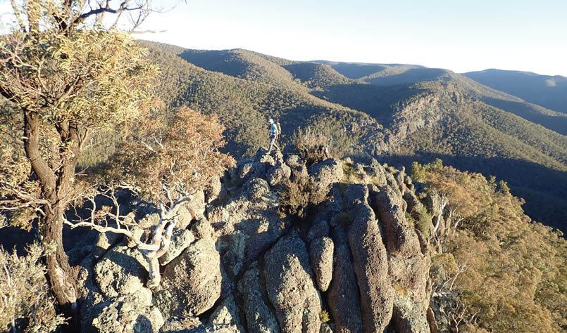
Looking north from our campsite along the edge of North Spur
planned distance, but more importantly this area provided plenty of flat camping and incredible views for us to sit and enjoy the afternoon sun.
We made camp among the trees at a particularly pleasant spot before bringing out a collection of wine, cheese and snacks. The wind had eased right off and the weather was surprisingly warm for the time of year, so there was nothing dragging us away from the sight of the sun dipping over the beautiful landscape.
When evening arrived, Penny took advantage of the clear sky to share some astronomical knowledge, pointing out numerous planets and constellations. The Milky Way put on an incredible display, with the smear of countless stars and galaxies cutting across the moonless sky. And with so much time looking upwards we were rewarded with the streaks of quite a few shooting stars.
North Spur to Turon State ForestA lack of morning people meant a sluggish start the next day. After finally dragging ourselves out of the cosiness of the sleeping bags we made it only as far as the cliff edge before settling in for a long breakfast.
When we eventually departed we were rewarded with easy walking along the open ridge. Another natural clearing — this one with the remnants of an old farm fence — marked the start of our descent into a deep valley below. Following the rocky nose, we startled the same herd of goats from the previous day. Before long we spotted the goats across the valley, wandering across improbably-looking ledges as they climbed the cliffs on the other side.
We made our way into Middle Arm Creek, which had been one of the areas I was keen to examine. We were met with a pool of clear water between boulders, while a stand of casuarinas soared above.
With packs off, we clambered upstream. It was beautiful walking with very little scrub and in places was almost canyon-like as the curved rocky walls closed in. The watercourse cut a zigzag through the landscape as it fought its way through the angled bedrock, before suddenly transitioning into a flat, open valley. We turned back at this point. On our return downstream we scurried up into a side gully where Boris’ request to see a wombat was half answered by the discovery of a recently deceased specimen.
The next challenge was going to be getting back out of this creek on the other side. From our vantage point across the valley the cliffs looked quite imposing. We considered trying to follow the route we’d watched the goats climb, but Kosta was convinced a short, steep gully looked promising.
His hunch was spot on and the gully provided a surprisingly easy route through the cliffs. From a few rocky outcrops we enjoyed views back into the valley and across to the ridge we’d followed down.
Another solid uphill slog returned us to the escarpment. More stunning views followed before we dipped downhill to cross a small gully. Once again we stumbled on the poor goats, who by now must have been particularly paranoid about the odd group of people who had been tailing them for more than a day. Not long after we startled
10 | BWA October 2020
a wombat that demonstrated the species’ surprising speed and agility as it raced down the steep gully and disappeared out of sight.
As we approached the final large creek that cuts through the escarpment, we began to snake our way down rather than risk getting cliffed out. Before long we were in the beautiful and aptly named Clear Creek, with its pools of crystal-clear water. This was another of the creeks I’d been keen to explore, so with time on our side we dumped packs and started scrambling upwards. After half a kilometre or so it became clear we’d seen the best of the small cliffs. My hopes for something canyonish had been dashed, but the creek was still pretty.
Looking at the time, we decided against exploring another creek branch. We filled up with water before setting off for the final big ascent. On the topo map it didn’t look much. Sure, it was clearly steep, but there were no cliffs marked. But I knew that was deceptive, and the aerial images had shown what looked like an impressive rocky knife-edge.
Things started with an unrelenting climb through a beautiful open forest. As the verticality started to ease, the ridge began to narrow, with some small rocky sections. Soon we were at the main event. The ridge was just as narrow as I’d hoped. There were some rather exposed moves, with cliffs falling away on both sides, before we reached a gap. Thankfully, what looked at first glance like an impassable obstacle was easily avoided with a scramble on the less-steep eastern side.
Clambering along the ridge, the views were stunning. The late afternoon light had the cliffs glowing a deep orange as we looked back down the knife-edge at the terrain we’d covered earlier in the day. With the car parked nearby, I raced over and grabbed a bag of chips, returning to the impressive viewpoint where the five of us now sat, watching the sun go down.
We thought that was it for the adventure given all that was left was to collect our other car then head home, but as we raced along the rough dirt tracks I noticed something wasn’t right with how the car was handling.
Pulling over to check, I discovered a flat tyre. A quick change and we were off again.
We picked a better route through the pine forest this time, making it to the other car without trouble. But as the convoy drove back out I again noticed a problem. Sure enough, a second flat tyre. Unfortunately, Kosta was ahead of us so hadn’t seen us pull over. We took the tyre off and waited for the others to return. Thankfully, the spare from the other car fitted. With two flats and no spares, I nursed the car the rest of the way to the highway. It was with some relief that we got back to tar roads.
While the dirt roads had been rough, two flat tyres seemed like particularly bad luck and made us speculate whether we’d fallen victim to some sabotage, particularly as there had been fresh dirt bike tracks near the car that had suffered both flats. Still, a couple flat tires were a small price to pay for a spectacular weekend exploring a truly remarkable area.


Tim (aka T2) lives in Springwood in the Blue Mountains with his partner Bron and four children, including recent addition River. He is a passionate canyoner and bushwalker, with a particular love for exploratory and off-track adventures. He works as a communications consultant, is one of the founding members of the Fat Canyoners, and also runs Canyon Gear.

BWA October 2020 | 11