

In September my partner Richard and I decided it was time to get the camping trailer out of storage and GO somewhere. We'd bought it early last year and used it for three months in NT and Queensland but, since then, for medical, as well as all the well-known reasons, it hadn't been out. Since we could only go within NSW, that's where we went. Besides, that's what the ads tell you to do - see your own state. So I thought I'd share our trip in case someone else needs ideas. Also, as nowhere is more than a day's drive from Sydney, this trip can be done in stages as time permits.
Sandstone Caves CircuitAll photos by Richard Graylin and Yvonne Lollback

Tripping in NSW
Yvonne Lollback

12 | BWA December 2020
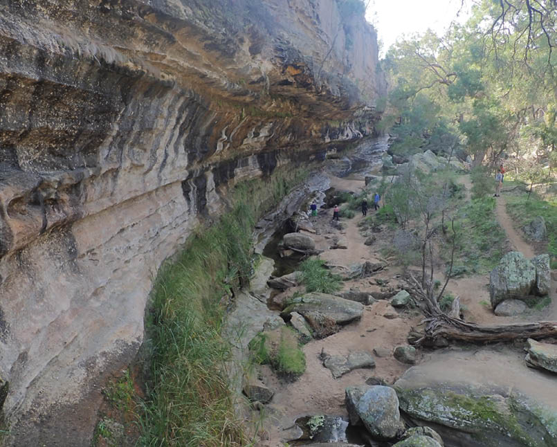

The Drip
Working with friends of the ColoIt started with a weekend late in August on the Putty River with Friends of the Colo doing some planting and removing weeds. This group has been working at ridding the Colo River and tributaries of various weeds for over 20 years since someone decided willows needed to be treated. They are a group which show what sheer determination can do. We had numerous visits from a swallow checking out our annexe to hang its nest from, if only the wind would stop moving the canvas. Some mice had also decided our peg bag might make a cosy home.
From CassilusAfter we left there we continued up Putty Road to Singleton and a base camp at the bowling club campground at Cassilis for three nights. It's a lovely, very cheap, rural little camping place. From there we were easily able to visit The Drip south of Cassilis near Ulan.
This is a very long, tall cliff wall dripping with ferns, mosses and lichens beside the beginning of the Goulburn River and is now protected as part of that national park. Though the return walk is under three kilometres, allow plenty of time to just be in awe because it really is beautiful. Nearby is the Hands on the Rock Aboriginal site which has numerous hand prints believed to have been done by women and children. Coolah Tops, north of Cassilis, was our next port of call though the eastern end was still closed. However we filled the day nicely with a walk taking in Norfolk and Bald Hill Falls both of which tumble down basalt columns. The Pinnacle Lookout was our lunch spot and then a visit to the Giant Grass Trees topped the day off beautifully, particularly as the trees were all flowering. For those wanting more there's the Goulburn River National Park and the Widden Valley.
BWA December 2020 | 13


Above The Breadknife, Warrumbungles
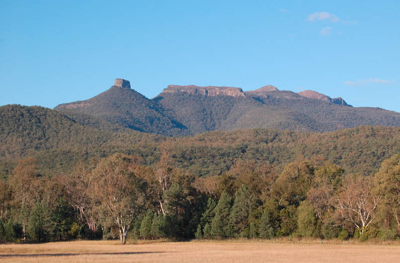
The WarrumbunglesFrom there, we headed up to the Warrumbungles. I discovered all sorts of fascinating geological facts through my geologist partner and via an app which tells you what to look out for as you walk along. It is well worth getting, not my Richard who is mine to keep but the app. The first walk, of course, was the Grand High Tops Walk which was just mind-blowing again even though I've done it several times. The app made it so much more interesting as well. You can stand at a feature, study the rocks and know how they ended up there looking like they do. Split Rock was another half day's walk and there are several other short walks nearby. For the really fit there's Mount Moffatt but we decided to leave it. I won't go into more details as excellent brochures are available. We learnt that this area, and Mount Kaputar, were created as Australia drifted north and passed over a particular hotspot in the earth's crust. Mount Warning and others were also made from this same spot which is now under Bass Strait.
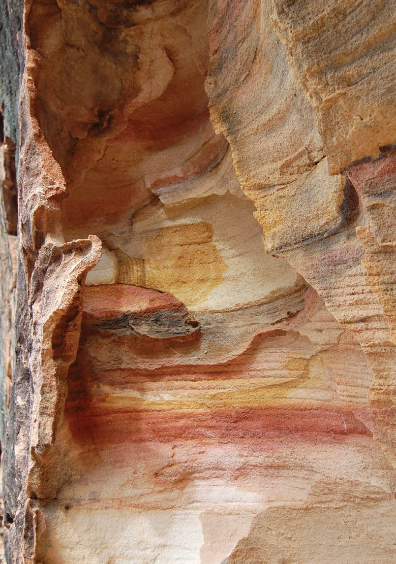
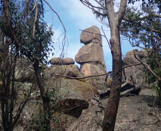
Sandstone caves and sculpturesNext was Mount Kaputar but, on the way, I took Richard to the Sandstones Caves which are well worth the short circular walk. They are not signposted but are 35 kilometres north of Coonabarabran on the way to Narrabri. Look out for the Yaminbah Trail which is on your right. It's only one kilometres to the carpark. The track head has information boards and the track is well made and easy to walk as it goes round. The sandstone cliffs change in colour and the weathering has caused stunning shapes with arches and caves further around. There is even a viewing seat over the Pilliga Forest and some Aboriginal rock art. This is well worth a few hours of your time.
Sculptures in the Scrub
“You can stand at a feature, study the rocks and know how they ended up there looking like they do.
BWA December 2020 | 15
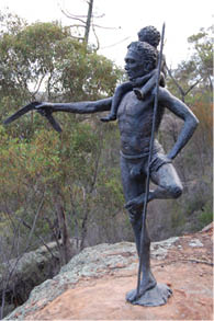
Further up the road you can turn left on No 1 Break Road for about 20 kilometres and left again onto the Top Crossing Road to see the Sculptures in the Scrub set above Dantry Gorge. These are a group of five sculptures done by local indigenous artists with boards telling about them and explaining the art. They are really magnificent with each set being totally different from the others. A very pleasant walk takes you past the works, down into the gorge, which is not deep, and back to the carpark. I'd been there before but it was worth this second visit. There is also a very nice campsite nearby. The long drive to the marked Salt Caves is not worth it - there's nothing really to see.
Mount Kaputar and surroundsWe ended up spending five nights in Narrabri because we really loved this friendly little town. We spent two separate days in Mount Kaputar NP though, of course, you can camp up there too. Some walks were still closed after the devastating fires of late 2019 but two walks I really recommend are The
Governor and Mount Coryah. This latter walk has brilliant dripping rock faces studded with lichens, mosses and ferns. Around the other side is a Grass Tree alley ledge which you have to walk through to believe. Again they were in flower. What a bonus. Good brochures are available as there are many other great walks. Another day we drove to Sawn Rocks, rhyolite columnar cracking at its most magnificent, best seen in the morning light. Huge chunks have fallen from the cliff face into the creek and look like piles of enormous logs stacked up. Then we continued to Waa Gorge which is well worth the four or more gates you need to open and shut. This return walk of 2.5 kilometres has short canyon sections, waterfalls and pools and ends in a really huge amphitheatre, again with rhyolite columns lying around. With care it is possible to climb up a fair way but getting down wasn't quite so easy. We had a quick look up at the other tributary which ends in a short canyon and waterfall. Really pretty and worth a visit too.
The approach to Mount Kaputar
“This latter walk has brilliant dripping rock faces studded with lichens, mosses and ferns.
“Then we continued to Waa Gorge which is well worth the four or more gates you need to open and shut.
16 | BWA December 2020

Wollomombi Falls
From the tourist info book we found out about Dripping Rock. It's towards Boggabri, turning left towards Manila after Gins Leap Rest Area on the right - a big cliff you can't miss. There are good signs after this though the last section does cross a creek and will need a higher clearance vehicle. Anyway the "rock" itself is only a very short walk and is actually another huge amphitheatre but with sheer walls this time, much of it dripping. We were lucky as the waterfall was flowing and the pool below would be great in the summer. This is a lovely place for a picnic and explore though the numerous snake warnings are a bit off-putting. A small cave up on the left is worth the short climb.
Hot artesian poolsHeading north we decided to try out the hot artesian pools at Moree. The waters are supposed to have healing properties but I found the heavy use of chlorine very off-putting. However, if you love hot artesian bores, Steve Lambert has put out a book called Australia's Great Thermal Way.
Armidale and surroundsFrom there we headed east to Armidale. On the way we stopped at Cranky Rocks, east of Warialda, again a short walk to a pool surrounded by huge granite impossibly-balanced boulders piled up. There's also a viewing platform overlooking the pool. The camp ground looked very inviting but we decided to press on. Once we had set up in Armidale, we spent the next few days visiting all the fabulous gorges and waterfalls of this area - Dangars, Wollomombi and Bakers Creek. Most have lovely rim top walks with great views. Armidale Tourist centre has brochures on each one as well as history walks. This whole area has been tilted vertically so the gorges look very different from the gorges in, say, the Blue Mountains. We also went to Gara Gorge for an interesting walk looking at the flume line and gorge where a hydro power station was built in 1895 to power the antimony mining town of Hillgrove, seven kilometres away. This was a first in Australia. How they managed to build and maintain anything at the bottom of that steep, constantly eroding gorge is beyond me. The next day we went to Hillgrove itself which is a remnant of what it was, but plaques help you to visualise it as a
“The waters are supposed to have healing properties but I found the heavy use of chlorine very off-putting.
BWA December 2020 | 17
Yvonne started bushwalking as a child with her mother, who loved exploring new areas, later taking her infant's class on small Katoomba walks. Yvonne has lived in the Blue Mountains since 1983. Canyons were always a great thrill, with overnight walk favourites being the Grand Traverse above Newnes and the Budawangs. It was a pleasure to take her children and family members on walks and go walking overseas. Now in her early 70s her body is starting to tell her she's ageing, but she's inspired by those in their 80s still walking. She only wants to go to Heaven if there are lots of great walking tracks.

thriving place even bigger than Armidale was then. There's also a museum but it wasn't open just then. I also had to do a walk down memory lane in Armidale itself as I went to Teachers College there 53 years ago.
Dorrigo and surroundsLeaving my memories, we headed east again along the Waterfall Way with a stop at the New England National Park and Point Lookout where we did the beautiful 2.5 kilometres Weeping Rock/Eagles Nest circuit. This takes in dripping basalt rock faces and amazing lookouts over the Macleay Valley filled with Antarctic Beeches. Surprisingly, two different types of white everlasting daisies were flowering profusely on the cliffs - last flower I would have expected in a rainforest. The Cascades Walk was next but it wasn't quite as beautiful as the brochure boasts. That night we stopped at the Little Styx River camping site just before you enter the park. It's free, grassy, shady and beside a babbling brook. And we had it to ourselves. What more could you want?
The next day we stopped at Cathedral Rocks to do the 5.8 kilometres round walk of these magnificent granite tors. A 400 metre climb takes you right to the top for wonderful views but this is not for the timid. Then on to Ebor Falls with its lookouts over the upper and lower falls. These were sort of closed because of the fire damage but were still easily accessible. The rocks at Ebor Falls were created when Ebor Volcano, which last erupted only 19 million years ago, was active and has left layers of basaltic rock behind the upper falls and interesting basaltic columns near the lower falls. These falls are part of
the Guy Fawkes National Park which has more to see but we'll do them another time when we include the whole Grafton area and surrounds.
Dorrigo was our next stop for three nights to do some beautiful rainforest walks in the Dorrigo NP. The rainforest information centre alone deserves some time to go through and the raised bird observation walk is wonderful for bird lovers. We were lucky enough, on The Wonga Walk, to see a goanna, and later a mullet lizard, just resting beside the tracks. I was even able to photograph them. Dangar Falls nearby, is also a pleasant spot especially if you like to swim. The round drive north of Dorrigo to Platypus Flat had some short walks to giant Tallow and Carbeen Trees but, again, the recent fires have really scarred the area.
The coast around KempseyAfter Dorrigo we went to Kempsey to do some walks along the coast at South West Rocks, Hat Head and Crescent Head. The Hat Head circuit includes a fabulous narrow tunnel chasm into which the sea surges. We were lucky enough to see dolphins playing just below us. We thought of going back up towards Walcha for more waterfalls but decided we'd had enough. Besides, last September was one of the coolest, blowiest Septembers I could remember. Time for our home comforts and to plan our next trip.
Cathedral Rocks


“... the raised bird observation walk is wonderful for bird lovers.
18 | BWA December 2020