The Ettrema wilderness is 120 kilometres south of Sydney in the coastal hinterland south-west of Nowra.
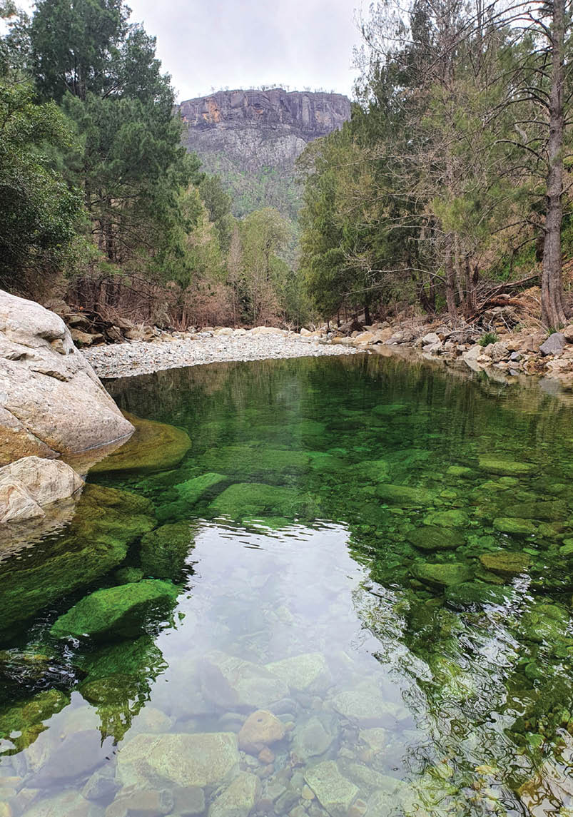
This area, which gently slopes to the north and east from a height of around 750 metres, is characterised by huge rock platforms split by streams which inevitably fall over high waterfalls on their way to meeting the Shoalhaven. The gorges are steep sided and rough but the boulder-strewn waterways which run through the middle of these are some of the most beautiful you will see in Australia.
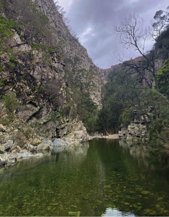
Near Camp 2Helen Jones

Ettrema Wilderness
Rob Wildman

6 | BWA December 2020
Burnt out Xanthorea above the creek near Camp 1 Helen Jones
The Shoalhaven River starts its relatively short journey from the hills south of Braidwood and grinds its way north through a magnificent gorge until it swings east to the Tallowa Dam and finally Nowra. The high country to the east of this forms, in part, the Budawang and Ettrema Wilderness. The main road linking Nowra to Braidwood and Canberra cuts these areas in two, and the tableland north of this road is where you find the wonderful wild Ettrema Creek.
The political battle to ensure this area was declared a wilderness has been ongoing since 1937 and was fought at every turn by miners, dams and loggers. There are still many areas not included in the park because they are freehold farms or reserved by the government for potential gold mining or possible dams. However, the wilderness we do have is magnificent and well worth a visit.
A word of warning for your adventure; there are effectively no tracks throughout the whole of Ettrema, Tullyangela and Bundundah gorges and navigation can be difficult because of some extensive areas of scrub and unexpected cliffs. The best seasons for visiting this area are spring and autumn as summer can be too hot. But the water’s nice then!
The walkWalk dates 10-12 September 2020Walkers Rob Wildman, Josh Neri, Helen Jones, Max Dona, Clay O'Brien
The descentWe had three days to cover what, in the final analysis, was a very short distance of about 20 kilometres. I decided to take the extra time because on every other trip in this area I had simply run out of time and energy. This time I was the only member who had actually been in this area before and so I wanted the group to enjoy this beautiful country as much as I had.
Given that the National Parks Service had opened up Morton National Park north of the Braidwood Road when pretty much everything else was either closed or access roads were cut, and that the fires had burnt this area to a cinder only a few months earlier, it seemed like a good option for a slightly extended walk. A few weeks before the start, we saw this part of the south coast receive something like 300 mm of rain in two days. The national parks workers were getting bogged on the access road so we really didn't know what to expect.
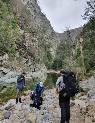
Max, Rob and Clay about to deep wadeHelen Jones
“... fires had burnt this area to a cinder only a few months earlier ...
BWA December 2020 | 7

Just before Camp 1 - first mandatory wadeHelen Jones
I was particularly keen to get into the area because normally the scrub found on the high rock platforms can be impenetrable. So much so, trips in here need to be carefully planned to allow for this. This time we found vast swathes of open country with lots of spindly blackened stalks of Banksia and other scrub typical of this area. The ground was often soft underfoot as well.
The starting point was Quiera Clearing, a small privately owned basalt outcrop in a sea of agricultural desert. Since I had been here last, the clearing was no more a clearing; the owners had decided to fence the open grassy areas and then carve a new track around the property. Instead of heading across the clearing to join the initial open ridge, the new track takes you straight down to the gully on the northern side of the ridge. The effect of this is that it actually cuts off quite a bit and you get to the top of the slot into Myall Creek earlier than expected. Whether this will remain as scrub free as it is now will be interesting to watch.
Myall Creek, one of the traditional routes into the gorge, was quite changed, with many of the original large logs gone and many more new ones in their place. The fire must have been fierce here since the ground on
the slopes of the sides of the creek was pretty broken up and loose with lots of sharp rocks. Heading to Jingles Pass was a cinch as there was hardly any of the typical scrub in our way. You could almost see the path from halfway across the plateau. It was a good spot to train young Max in using a compass. While my own reliance on modern electronic equipment has grown over the years, reminding oneself on how these work is still important. A compass doesn’t usually run out of battery.
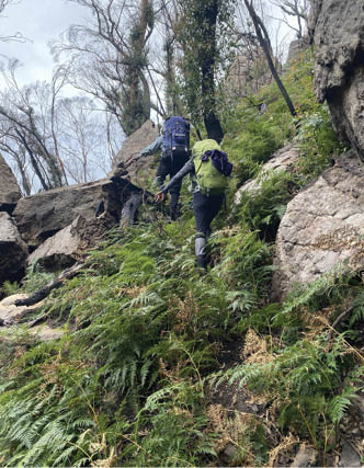
Rob and Helen leading the way to the ridge downClay O'Brien
Sundews (Drosera) on the ash-filled plateauxClay O'Brien
8 | BWA December 2020

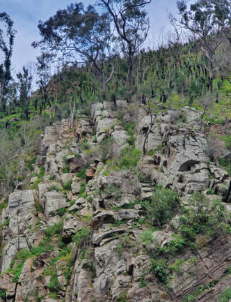
Coming through the pass, we saw a lot of fire damage with split boulders and many new burnt logs across the path. We headed to our right to gain the top of the ridge before the descent and there was no trace of the old pad which guided you there.
As usual the descent to the creek was steep but this time there was the added danger of not being able to see where your next footfall was going to be. After the fires, there had been a spurt in small green wide-leafed growth covering most of the ground so each step had to be tested for a hole, a log or just nothing. I think it took about 1.5 hours to reach the creek this time. With the first pool providing a place to stop and look around, the whole group were now starting to see why we had come to this area.
The walk down Ettrema Creek always had lots of crossing and wading through pools. There had been a party down before us and they had constructed the strangest "house" of stones just past the junction with Myall Creek. I wondered if they actually used this for a camp, ignoring the now weed-infested original camp site just back at the same junction.
The flood had appeared to have risen quite high in this narrow gorge, for when we finally arrived at the Jones Creek junction camp site, the water had clearly been running freely over this area, some two metres or so above the normal river height. The old camp site was still usable but sites had to be selected carefully. There are very few camp spots on Ettrema Creek and this is usually one of the best, being right beside the stream and under the magnificent rising wall of Thompson’s Cliff. Helen even spotted a bounding wallaby high up on the scree slopes in the burnt out grass trees.
Reflecting timeThe next morning, we decided to wake late and wander up Jones Creek returning before lunch. This tributary to Ettrema Creek, full of beautiful cascades, pools and even a very high waterfall, had been the centre of one of the big fights over the declaration of wilderness, only being settled as late as 1979. There are still well documented mining shafts and relics further up the creek.
After a short stroll you arrive at the first wonderful big pool, which had native orchids, almost in bloom, hanging from a nearby
Copyright: Crown Lands NSW
BWA December 2020 | 9


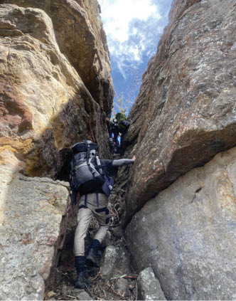
Ascending the first cutting onto Pardon Point Clay O'Brien
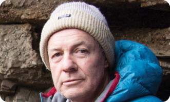
Rob is 67 and is based in Sydney. He has been bushwalking since the age of twelve, when he was dragged up The Castle and into a casual love affair with the bush. For years his stomping grounds were the Budawangs, Blue Mountains and Kanangra but Tasmania and the Snowies have been poking their nose in for a while. He often tries out poor unsuspecting first timers on impossible routes but somehow always makes it back to safety. Well, there was that one time with the helicopter ... For Rob, going bush is where the rejuvenation of the senses and the intimacy with nature always happens.
tree. We decided just to laze around it was so lovely. Josh even dived in but came up with a mouth full of expletives so cold was the water. He says he was just chilling out. Retracing the creek, we returned to the tents, packed and started on the dawdle down to … well, we didn’t know where we could camp again. Who cared anyway as the weather had gone cloudless and warm and Ettrema Creek was just too inviting.
The amble down the creek was glorious and we spent quite some time just being amazed by the water and the steep inclines on both sides. This section is a mixture of boulder skipping interspersed with mandatory wades. Everywhere there was evidence of how the creek must have roared through this defile when full of water.
Reaching the junction of Transportation Spur and Ettrema Creek by mid afternoon, we set up camp, in what was, the only other camp spot in the whole day's walking. Again, we started a fire, cracked open the wine, cheeses and cigars for a relaxing end to the day. Laid out in front of our sandy camp, was another emerald pool sitting under an earth red cliff which was adorned by a set of fig roots stretching metres above to some tree we couldn’t see.
Day outNext day, Transportation Spur was an absolute grind but the hill gives you a break about half way up when the slope becomes gentle and the soil stops slipping from under your boots. Going up this spur was a lot easier than coming down from Jingles Pass in terms of visibility of the ground in front of you. The final climb up to Pardon Point is a little tricky and requires some initial scrambling to take you to quite a narrow ledge but beyond that the final slot is easy, although now filled with a tree requiring some pack passing. At the top, we saw our third soaring wedge tail eagle as we took time to rest before the last section.
The trip back to the car was a wonderful meandering stroll around the low edges of the high plateau. Here we were very glad to have had the services of the fire for the scrub was thin and easily navigated. And this time, because of the earlier rain, there was so much water just seeping out of the soil and so all the normally dry streams were actually flowing with lovely clear and cold water. What a surprise.
The area is always spectacular, still one of the treasures of Morton National Park.

10 | BWA December 2020