

The Freycinet Circuit is a rewarding circular hike that combines picturesque bays, turquoise water and majestic views of the Tasmanian coast.
Reaching Cooks Beach at the end of day 1All pictures by Oliver Descoeudres

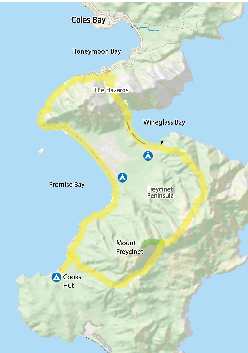
Freycinet Circuit
Oliver Descoeudres

20 | BWA February 2021
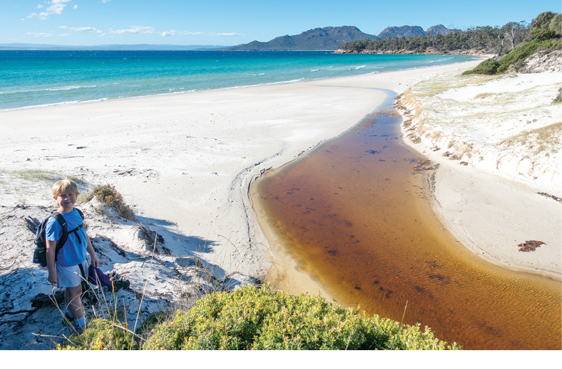
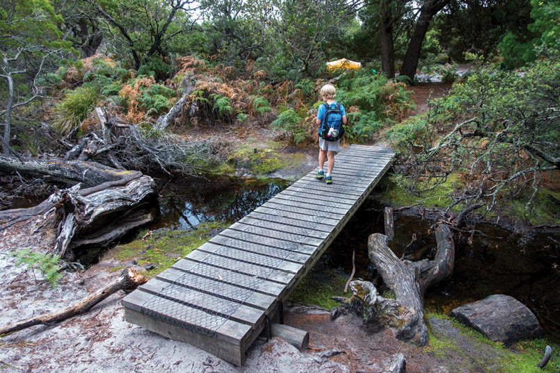
Luke on Cooks Beach
This circuit of Freycinet Peninsula, one of Tasmania’s “Great Bushwalks”, has been on my to do list for a long time. It was originally intended as a long one-day hike, but with my eight-year son Luke showing increasing enthusiasm for hiking and camping it became a two night three day adventure. It’s been many years since I’ve walked with a 20 kilogram pack and the first time Luke’s been on an overnight walk. So this could be a great experience … or the chance to see how effective my emergency beacon is!
We arrived in Launceston the evening before our walk and stayed with a Taswegian friend overnight, so we can make a relatively early start the following day for the 2.5 hour drive to Coles Bay. There’s time for an egg and bacon roll before we hit the track – the last palatable food for the next 48 hours.
Day 1 - Wineglass Bay to Cooks Beach15.3 kilometres, 205 metres climbingAt 11 am we’re on the track from Wineglass Bay car park to Hazards Beach. It’s a slow start, with a friendly wallaby posing for photos at the trackhead. Despite signs saying “don’t feed the wildlife”, this wallaby was very tame and was obviously used to receiving food from tourists. At least it had been fed fruit, and not bread which is bad for them. I was happy it was a friendly one; the
signs along the road to Freycinet were rather ominous and warned of kangaroos that would flip your vehicle with a single paw. It’s not surprising that international visitors are scared of our wildlife!
The first five kilometres were relatively flat, with the track following the coast from the car park to Hazards Beach, said to be named after local whaler, African-American Captain Richard Hazard. It’s pleasant walking, despite being a warm day and carrying a heavy pack, which I’m not used to. There are views out to the west over Promise Bay towards Swansea and the Eastern Tiers.
After about 1.5 hours we’ve almost reached Hazards Beach, and just before we get there we spotted an idyllic bay. Across the (almost warm) turquoise water is Mount Freycinet and Mount Graham, which we will climb tomorrow. Unlike the exposed beach, this spot had plenty of shade and another friendly wallaby. We stopped here for lunch and a swim.
Reluctantly, we left the bay around 2:30 pm, continuing our walk along Hazards Beach. The beach doesn’t disappoint either: we could easily have spent a few hours lingering here, except that we have a campsite to get to.
BWA February 2021 | 21

Descending to Wineglass Bay from Mount Graham
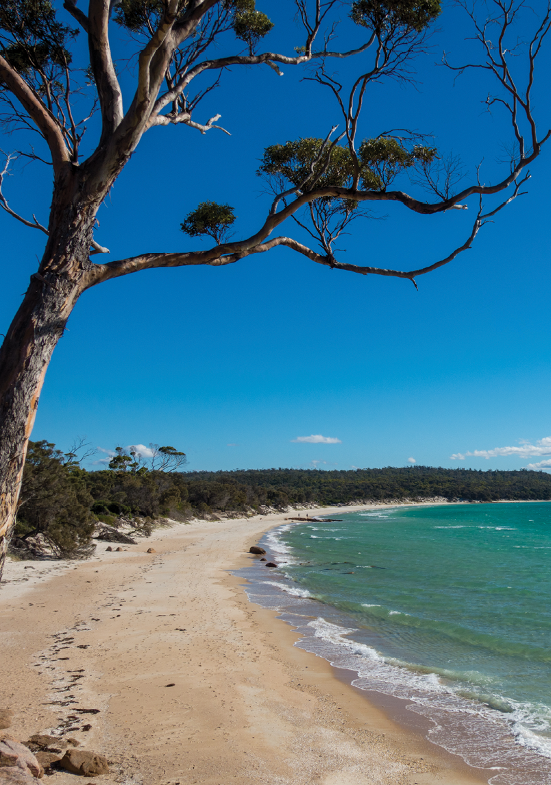
The campsite at the end of the beach was shaded and fairly empty. From here the track followed the coast through low scrub and casuarina trees. While there was some shade, this section of track felt much longer than the four kilometres that it is. We were glad to reach Cooks Beach.
A short walk along Cooks Beach brought us to our camp site. We’ve covered about 15 kilometres, but it has been easy walking. We set up camp a stone’s throw from the ocean, on a small hill just before the entrance to the official campground. There’s water from a tank at Cooks Hut a stroll away, where we chatted to the friendly park volunteers before enjoying a hot chocolate and tea as the sun sets. Apart from my lamentable attempt at cooking sausages on my camp stove, it was a fantastic day.
Day 2 - Cooks Beach, Mount Freycinet, Wineglass Bay15 kilometres, 930 metres climbingWe woke early the next day. To be specific, Luke woke up early and told me I need to get up. I’d have been happy to snooze another couple of hours. We were underway around 7 am, heading back along Cooks Beach to the turn-off up to Mount Freycinet and Mount Graham. Today will be a big day.
From the northern end of Cooks Beach, the track ascends steadily up to and then along the East Freycinet saddle, gaining about 375 metres over 5 kilometres. It’s tough going after a very flat first day and carrying a heavy pack, but we’re walking through dry sclerophyll forest and in shade. It takes us just over two hours to reach the side-track to Mount Freycinet. I felt slightly bad telling Luke that climbing the highest peak in Freycinet National Park is not optional, and we leave our packs at the bottom.
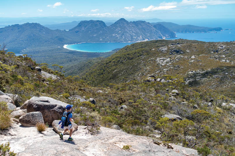
The climb is steep: only 750 metres in distance, but climbing from 375 metres up to the top at 620 metres. There are cairns and orange markers designating the rough track that goes directly up the side of the mountain, with some boulder scrambling at the top. As you approach the summit the views towards Wineglass Bay suggest it’s worth the effort. Luke doesn’t share my opinion. I am currently the Worst Dad in the World.
The view from the top is incredible, although I am not yet forgiven. You can see the main track continuing up over Mount Graham to the north-east. Directly north is a magnificent vista that takes in Hazards Beach and Wineglass Bay, with Hazards Lagoon in the
BWA February 2021 | 23

Arriving at Wineglass Bay campsite at the end of day 2
middle and The Hazards in the background. If you’re doing the Freycinet Peninsula circuit, it’s worth making the effort.
The descent is much quicker. We re-shoulder our packs at the bottom, and start our second ascent, up Mount Graham, 579 metres. We are now in full sun as the track climbs steadily through low heath to our second summit of the day.
Mount Graham is not really a peak – there’s a 100 metre distance pad up to the “summit” from the main track, with views of Mount Freycinet to the south and Wineglass Bay to the north. The views are not as dramatic as Mount Freycinet (which is more a collection of large boulders), but being a “flat” peak you get uninterrupted 360 degree views. Strong winds and some cool mist suggests how quickly the Tasmanian weather can change.
From here the track descends to Wineglass Bay, but remains exposed and it’s another section that feels much longer than it really is. Wineglass Bay still looks far away …
I’m unsure whether there is water at Wineglass Bay, so I’m hoping that we can replenish our water supplies on the way
down. We find a few unappealing, brackish streams before eventually striking a clear stream that crosses the track, Graham Creek. and we refill our three 1.5 litre water bottles. I explained to Luke that, worst case, we could suck the nectar out of Banksia flowers (although most were pretty dry).
Finally, we reach our camp for the second night, after 16 kilometres and almost 1000 metres of climbing. Wineglass Bay is rated one of the best beaches in the world by Traveller.com, UK Telegraph and Lonely Planet and other publications, and it is just spectacular. Clear, blue water and white sand with the peaks of The Hazards forming the background.
The only downside is the number of mosquitoes. The large campground, which is right on the water, is not full despite it being a summer weekend. But as all the premium waterfront plots are taken, we find a nice secluded camp site toward the back of the campground. Big mistake. I feel as we are the guests of honour at the Tasmanian National Mosquito Conference. I’ve never seen so many mozzies. We quickly cook our dinner (another culinary miss, with Luke
24 | BWA February 2021
Oliver lives in Sydney with his family, and drags his two children on bushwalks as often as he can. Working full time in the information technology industry during the week, he tries to get into the bush every weekend and has been hiking in Australia and overseas for almost forty years. He is also a Cub Scout leader in Sydney’s north region, and a keen photographer.
declaring my expensive Back Country Honey Soy Chicken packet a bunch of inedible vegetables), watch the sun set and climb into our tents. Despite this, we sleep well and are ready for the final hike out the next morning.
Day 3 - Wineglass Bay, Coles Bay5.2 kilometres, 225 metres climbingAnother early-ish (7:30 am) start – we are both ready for an egg and bacon roll and a cold drink at Coles Bay, after our last few meals … It should be pretty easy as we’re walking around Wineglass Bay along the beach, although the sand is soft and we can feel our muscles! Wineglass Bay looks pretty impressive from this angle too, this time with Mount Freycinet and Mount Graham in the background.
The track ascends from the north end of Wineglass Bay. Being a popular day walk, the track is now of a considerably higher standard, but we’ve got a 200 metre climb up to the Wineglass Bay lookout. For the first time in three days we start seeing a lot more people.
It’s not a bad view over Wineglass Bay … but we’ve been spoilt by the last two days and the weather is a bit overcast for the first time, although it soon clears. There are many people here, with the lookout rated as one of the “most photogenic destinations” in the world, according to Traveller.
It’s now all downhill for the last two or so kilometres, on a well-graded track that feels more like a highway than a track after last two days. We’re welcomed by another friendly wallaby, as we make our way back to the car park, and our well-earned egg and bacon roll. It’s been exactly 40 kilometre in 48 hours. We’ve both had a great time on our first overnight hike, and thinking about where we might go next …
Remarkably, after a bacon and egg roll I’ve been promoted from “Worst Dad in the World”, and Luke thinks that he might come on another bushwalk with me one day. Two years later, we complete an 80 kilometre walk around Maria Island – and the map of our Freycinet bushwalk takes pride of place on Luke’s bedroom wall.
Lessons and suggestionsIt’s been many years since I’ve done an overnight walk, and we’ve done pretty well with our preparation and gear. Next time, I’ll definitely be packing insect repellent. Some light-weight thongs or slippers would have been helpful around camp. And you can never bring too much wine.
If you’re not up for overnight camping, there are a few companies that offer Freycinet trips, often using boats to avoid sections of hiking and including accommodation in a lodge near Coles Bay.
Resources
Location Starts at the Wineglass Bay carpark, near Coles Bay. About 2.5 hours from Hobart or Launceston airports.
Distance 40 kilometre circuit, 1180 metres total ascent, 2-3 days.
Grade Moderate
Season/s All year round
Map TasMap Frecyinet National Park 1:50,000
GPS route AllTrails map with GPX download option
Top Walks in Tasmania (Melanie Ball), Walk 25, Amazon US / AU
Tasmanian Parks and Wildlife Freycinet Peninsula Circuit overview
For more walk ideas, see Hiking World.


BWA February 2021 | 25