


The mid-December 2019 plan ...
Start at the Upper Howqua camp ground.Head up Helicopter Spur.Night 1 - Camp at King Billy.Traverse the AAWT across Mount Magdala.Head across Mount Howitt.Head down Stanleys Name Spur (aka SNS).Night 2 - Camp near the water source on SNS.Head down SNS and then down Queens Spur Track to the Upper Howqua camp ground.All up, 26 kilometres over three days.
Ah, yes, it looked so good on the map, then in the pub, as we mulled over a beer. The Bonnie Doon pub, a beaut eating place as we headed up to Mansfield, then the Upper Howqua camping ground for the night.
Rock band 2All pictures by Nick Bean

Helicopter Spur, the Gentle Bastard of a ClimbNick Bean

6 | BWA February 2021


Track markers came in all shapes, sizes and types

At the top of the climb
Leaving the Bonnie Doon pub, it was a two hour drive to the first night's camp at the Upper Howqua Camp Ground. It was a reasonable dirt road for 2WD, and we took our time, being aware of wildlife. Just before dusk, we headed down the final dirt road, Bindaree Road. Arriving in fading light at a near empty ground, the tent was set up, mattresses were inflated, sleeping bags were set, and there was one last read through the next day’s hiking notes.
Day 1 - Upper Howqua camp ground to King Billy - 6.5 kilometres, hard walking and rock scramblingThe next day, a lucky Friday thirteenth, would see us up and moving just after 9 am. A few other campers had arrived at the camping ground, but it was a quiet start to a three day hike.
The first two kilometres we knew well, as we had assisted Bushwalking Victoria with a track clearing weekend in late November 2019. A moderate climb along an old logging track saw us reach the left turn towards the spur in 40 minutes. At this point, we noticed the Bird Orchid in flower. It was right next to the track, and easy to step on accidentally.
We went east, climbing through open scrub on a track that was easy to find as we simply had to keep to the top of the spur. A few fallen trees slowed our climb as we headed for our first challenge, the lowest of three rocky cliffs.
Approaching the first rocky band, we initially headed to the right of the spur, then, at the base of the cliff, the track swung to the left. Following a foot pad below the cliff, we found an easy route up the cliff.
The first rocky band wasn't too hard (from memory). The second was a little more involved. While we didn't need ropes going up, I suspect you would need them coming down. Or, just throw the packs down, as some folk were doing! Not a favourite idea of mine.
In the end, brute force and no ropes were required to climb the cliff. As a distraction, the amount of wild flowers in bloom was amazing. The track is fairly clear and easy to follow.
Rock band three was fairly easy. Finally, at the top of the climb, 740 metres above the start, we had a gentle rolling slope, with a beaut view looking back to the valley. Yes, a little weary, but we made it up the spur! Would do it again ... one day ...
Once off the climb, the track made its way to a dirt road, which passed Picture Point, then merged with Bluff Track. Easy walking.
“A few fallen trees slowed our climb as we headed for our first challenge ...
BWA February 2021 | 7

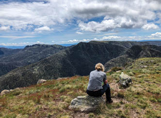
Carolyn takes a breather on Mount Magdala, Howitt and the Crosscut Saw in the background

Hells Window, as we descend Mount Magdala. Mt Buller in the distance
The first night's camp site had been mentioned to me by a Parks Victoria Ranger. It was about 250 metres off the main track, heading east, a beaut flat, green area to pitch a tent. But the issue with lots of black ant nests kept us searching. Stamp your foot on the ground, and if ants appear in 10 seconds, try elsewhere. Water was found about 200 metres to the north-east at a small creek, part of the King Billy Creek. It wasn't fast flowing but it was enough to fill up and cook with. This was a peaceful location. The rest of the crowd (around 5-6 4WDs) had camped back near the road.
Day 2 - King Billy, Howitt to Stanleys Name Spur - 10.4 kilometres Easy walking, up and downThe walk from King Billy to Mount Magdala is a little up and down, not a lot, but enough to raise a sweat, with stunning views as we followed the top of the cliffs. While Mac Springs is nearby, there were very few folks around. The biggest group we saw were 5-6 deer hunters. I wasn't really comfortable with
people shooting around these parts, but I suspect, the number of rangers to manage this sort of thing are very low.
We stopped for lunch below Mount Magdala, a great camp site, on a saddle, dotted with large old snow gums. This is near the path that leads to Hellfire Creek, about 400 metres along a well trodden path. Initially, as you head down the track, you wonder where the creek could be. It seems way off. But as you traverse around the slope, its there, with that beaut, water trickling sound.
“Stamp your foot on the ground, and if ants appear in 10 seconds, try elsewhere.
8 | BWA February 2021


Lower reaches of the Queens Spur Track, as it merges with the Howqua River
The start of the descent down Stanleys Name Spur intersects with the Crosscut Saw track. The first kilometre down to the camp site is a little rocky and challenging, but worth it. Initially, the descent starts off well, the track is clear, but soon it becomes an undefined scramble. The approach is to simply follow the ridge and the odd rock cairn. Plus the scramble marks.
The second campsite was on the small plateau about a kilometre down from the start of the descent. Around 100 metres away was a beautiful flowing stream, the headwaters of the King River. There was not a lot of choice for a tent site, but we arrived at around threeish and had the place to ourselves. A couple of hours later, a group of young guys arrived, from the Upper Howqua camping area. In my view this was a bit of a long slog, up Queens Spur Track, then Stanleys Name Spur. We were heading in the other direction, tomorrow.
Day 3 - Stanleys Name Spur back to the car (at Upper Howqua camp ground) - 9.4 kilometres Easy walking, mostly downhillThe weather was perfect. Having breakfast and packing up, we were walking by 8:30 am. I was glad we stopped here as its been on my list to check out for a number of years. The water source, the views, just great. The track, for the next 1.5 kilometres, down to the start of the Queens Spur track is easy to follow. Mostly a ridge track, keeping to the highest point. A few yellow markers reassure
the walker that they are heading in the right direction. A fair number of fallen trees slowed our progress.
The only "tricky" navigation bit is the last kilometres before the intersection of Stanleys Name Spur track and Queens Spur track. The SNS track heads around an outcrop of red rocks, then heads due west, through some knee/waist high growth, then through a wall of understorey. The track through this waist high scrub is easy to follow. The understorey can be a little difficult as deer have made tracks through this section, which is a little misleading. Fortunately, some pink flagging tape marks the entrance. Our first attempt a few years back didn't have this tape and it took a few goes to work out where the start was. Once through this section, probably 500 metres, it opens up to a grassy meadow. Head down this grassy section to a saddle,

The creek near Stanleys Name Spur track
“A fair number of fallen trees slowed our progress.
“The understorey can be a little difficult as deer have made tracks through this section, which is a little misleading.
BWA February 2021 | 9
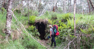
Old fire bunker, near the intersection of Queens Spur Track and Stanleys Name Spur
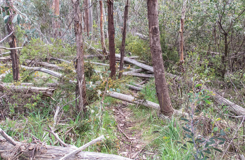


Stanleys Name Spur Track, a few fallen trees to deal with
Nick is from Melbourne and has spent most of his working life in IT. He has been bushwalking for 40 years, trekking in mountainous parts of Australia, Chile and Argentina. Of late he has gone on multi-day walks, such as the AAWT. A passion in photography has meant there are times when camera gear almost outweighs essential items. Carolyn is from Manjimup, Western Australia, and has spent her working life nursing. Between nursing stints, she travelled, walked and cycled around the globe. Most memorable are cycling large parts of Australia, Tasmania and England, trekking in Nepal, and six months In Africa.
where the Queens Spur track appears to the left (the well trampled foot pad is the giveaway). At this intersection, an old track heads west over Mount Thorn, north, along the very overgrown section of the Queens Spur Track towards Mount Buggery, or south, back to the Upper Howqua camp ground.
On the lower sections of Queens Spur Track, the native fernery display is magic. Such a lush green environment. On many other walks we have done here, we would head up Howitt Spur, then back down Stanleys Name Spur or Queens Spur, so it was a great adventure, doing Helicopter Spur, that gentle bastard of a climb.
For more pictures see Dirt tracks wandering.

10 | BWA February 2021