

A Short Walk Through the Chewings
Text and photosRob Wildman
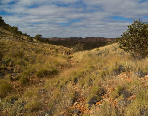
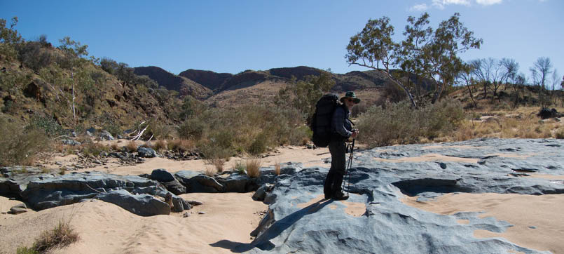
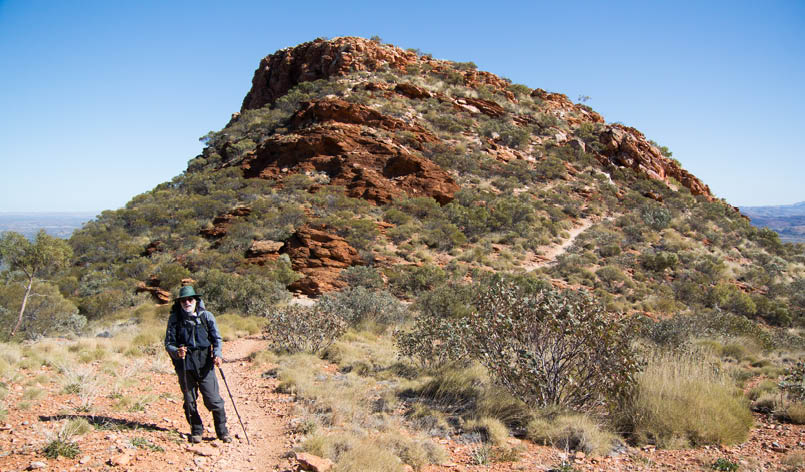
Looking west from Hill Top on the Larapinta towards Rocky Bar Gap
A year ago, my friend Frank mused about driving to Central Australia as he’d never been there, and having just retired, thought it would be something to do. Nice idea but when Google maps came back with a driving time of 26 hours to Alice Springs, the whole kernel of the trip was evolving by the minute. Okay, so now we would fly and then do a walk. Larapinta Trail? Why not?

14 | Bushwalk October 2022
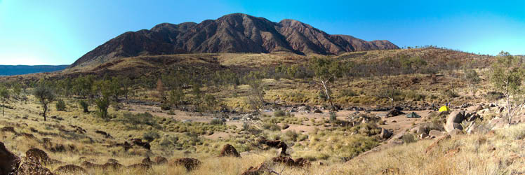
Looking back towards the Heavitree Range
The more we researched, the more we kept seeing this Namatjira-like mountain range in the background; the Chewings. Named after a very energetic South Australian who explored this whole area in the 1860s (for how it could make money, of course), the Chewings also had the second highest peak in the area, Mount Giles, and some attractive ups and downs. Adding in two other walkers, we had the final package: a 12 day walk broken into eight days off-track and then four on the Larapinta.
The LarapintaThe Larapinta Trail itself stretches from just north of Alice to Mount Sonder, some 150 kilometres almost directly west of the town. Originating in the 1980s and 1990s, it cobbled together a whole series of smaller trails in order to become one of the premier walking trails in the world, continually attracting walkers/hikers/trampers from all around the world. The national park which encompasses both the Larapinta Trail and the one mountain range to its north, the Chewings, is the Tjoritja National Park or, and this is much less evocative, the West MacDonnell Ranges National Park, which is jointly managed by the government and the Traditional Owners.
There is a huge local industry associated with the support of walkers along this trail, and this includes cafes, transport to and from the trailheads, private tourist facilities like campgrounds and accommodation and, of course, the Tjoritja National Park machinery which ensures that there is always water available and adequate infrastructure for walker comfort.
The ChewingsWe had finally decided to do an eight day walk in the Chewings first and then follow this up with four days on the Larapinta. I was interested to see what the difference would be between having to deal with untracked open country and following a set trail with possibly many walkers. Would it make that much difference given we were walking through much the same country, climbing the same hills?
While the plan was to start our walk from Hugh Gorge, the 4WD track into this point had been washed away in the January rains. So, under an enormous sky and a crisp, cool morning, we found ourselves overwhelmed by the beauty of our new starting point, Ellery Big Hole. The colours of the rock walls contrasting with the chalk white of the trunks of the gums
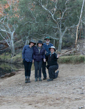
The start at Ellery Creek Big Hole: Helen, Michelle, Frank and Rob
15
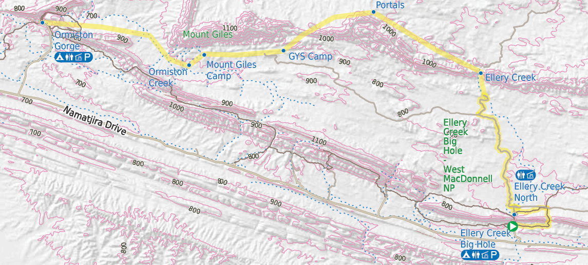
Map of the walk
0 km 2 3 4 km

Start of the walk
Picnic shelter
Campsite
Toilet
Parking


Road, four-wheel drive track, walking track (treed)
Main track, side trip, alternate route
Cliff, major contour line, minor contour line (50 metre interval)
Lake, river, waterfall or creek


This map is © Bushwalk.com and is created using data © OpenStreetMap contributors

16 | Bushwalk October 2022
clinging to the cliffs was everything we had read about. All of this reflecting in a deep pool which passed through the gap in the range. We all goofed about taking photos. Philippo, our driver, expressed optimism that we would see him in twelve days at the other end of the range. I wasn’t so positive.
The startThe early section, our breaking-in part, was to take the Larapinta Trail through the next dry gap in the range and head around to Ellery Creek North, the trailhead for sections 6 and 7. Crossing through the range, we saw the magnificent Chewings dead ahead across the valley, some fourteen kilometres away. Arriving at the trailhead early, we decided to start the trek across Alice Valley. The day was bright and clear, there were some pools remaining in Ellery Creek and no flies, all leading us to load up with several litres of water and head down the old cattle track which cuts across the valley.
This was pleasant walking, even with the extra water and eight days of food. By mid-afternoon we reached a dry sandy creek bed and made camp. Time to sample the delights of our first night in the middle of nowhere. Keeping hands and feet warm was a challenge as the cool evening crept over us and the sun quietly dropped below the western mountains, leaving us with the first
of many wonderful, fiery sunsets. The light at this time is beguiling, almost like a blanket, making the harsh rocky outcrops soft and the velvet grasses of the plains appear smooth.
We were forced into bed soon enough but occasionally we crept out to watch the show that was going on above us. The milky way seemed to have been brush painted on, it was so intense.
We tried to imagine how this land had provided for the Arrernte people when we could only see its naked harshness. To survive here, people must have had strong connections and based their societies on sharing everything. Modern society doesn’t come close.
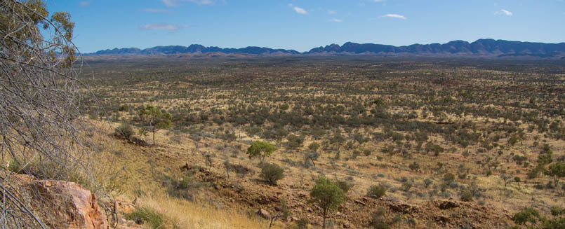
Across the Alice Valley towards the Chewings
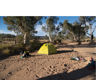
First night camp on an unnamed creek midway through Alice Valley
17
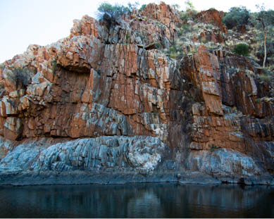
Ellery CreekThe road across the valley swung away to the west after the Cumming stock yard, a relic of what this country was used for prior to its declaration as a national park. We pushed through open country until we descended the banks of Ellery Creek close to the point where it dramatically cuts through the Chewings range. The creek was, as with most of these dry rivers, very sandy and, to give us some relief, we searched out patches of hard sand and rock. The base rock layer, usually coloured a light blue, appeared occasionally and nearly always contained some remnant pools from the rains in January.
Following the creek through the first break in the range, we found the glistening big pools and sandy beaches which became camp two. Ancient rocks, split into thousands of cracks and splashed with reds, yellows, greys and blue surrounded us making us somehow feel comfortable and safe. A couple of rock wallabies flitted across the two pools just as evening lowered around us.
In the first few days of the walk, we never learnt to deal with a gusty wind which seemed to come from many directions at once. We kept telling ourselves that it was because of the wind that we were not being plagued
by flies but that gave us little consolation in dealing with the sand being blown into the tents and, at one point, lifting one of the tents and sending it in cartwheels through the rough vegetation near the walls, ripping great holes in the fly.
Ellery Creek amazingly passes through the Chewings via a series of big loops, passing a well named spot called Fish Hole, which when we saw it, had plenty of water, although one suspects that more often than not there isn’t any water or fish to speak of. It then pushes its way out through the northern wall of the range. At this point, we broke off the main stream and headed up a side creek aiming to breach the top of the ridge and then head along the side of the range till we came to Portals Canyon. The route up the creek soon narrowed and became more ominous with the cliffs starting to tower overhead. We then met what we thought was the end of the road; the way forward involved two steep
Frank on blue rocks in Ellery Creek

"
... lifting one of the tents and sending it in cartwheels through the rough vegetation near the walls ...


18 | Bushwalk October 2022
sided slopes and a very deep, very cold pool in the middle. We were halfway through the third day’s walk and there was really no going back. We inched our way up the near vertical side, holding on magnetically to the patchy footholds and handholds. The higher we got the more menacing the dark pool appeared but a few expletives later and we were all safely through.
A superb small waterfall was next but nature had provided an easy path around and with our enthusiasm growing we climbed the last slope to the top of the ridge.
The valley ahead appeared very graceful and we were relieved at the thought of some easier walking for a while. Well, that lasted about one hundred metres before we were back into the rocks. For the next few hours, we dragged our feet over ridges followed by creek beds, some of which were deeply incised into the hill. We started seeing more birds of prey and at one point, just in front of us, stood a huge grey kangaroo. Flocks of tiny finches sprang unexpectedly from equally small trees giving us all an instant thrill.
Broken wall at Ellery Creek camp site
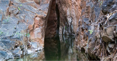
Portals Canyon We kept thinking we were at Portals Canyon on a number of occasions and the disappointment was palpable when we realised we had even more ridges and creeks to cross. At almost five in the evening, very tired and now thirsty, we spotted another human; a fellow walker obviously camped at the place we were heading for. It seemed to take forever to get there. At five thirty, tired, scratched and depleted, we bulldozed our tent sites in some very rocky, but flat, ground.
Portals Canyon is a very indistinct crack in the mountain. There is a trickle of a stream lazing through rock pools till it spills onto the sandy floor of the valley where it spreads and fosters
the growth of a small forest for some distance. But head back upstream and a magnificent walled canyon leads back into the bowels of the range. One member of the other group told me he swam through there ten years ago and almost ended up with hypothermia; it’s so cold. He said this, I think, as a kind of challenge to us mere weaklings and there’s no prizes for guessing what we didn’t do.
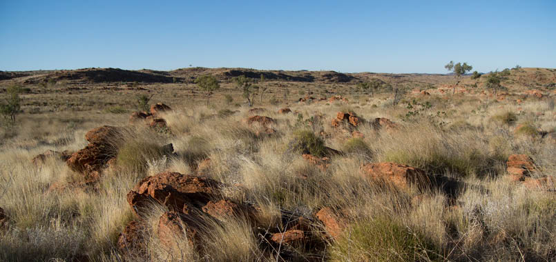
From the nearby hills it’s possible, like most places in this area, to see far into the northern section of the park. The yellow carpet just seems to go on and on, rolling gently till it bumps into a distant blue peak or another fold in the earth’s crust.
Passing through the range at Fish Hole, this time with water
19
Country to the north of Portals Canyon
Rest day and Giles Springs YardAfter a rest day, which is so worthwhile on a walk like this, we were ready to do the long plains walk to what’s termed the “low point in the range” where it is possible to cross back to the southern side of the range. The other group also decided on the same route, passing through bursts of beautiful red, yellow and purple wildflowers. We kept crossing their paths until we all ended up in the dry creek canyon just below the low point. Creeping back into the range, this creek revealed some shaded pools, some at creek level and others in a cascade which fell from the top of the range. I could imagine the water tumbling through each of these pools and rushing through the creek during a heavy storm.
We now needed to climb, chest to the wall, extending our spider fingers and clamber up out of the canyon. This is not inherently dangerous but with a large pack disturbing
the balance, it scared all of us to some extent. Once on top the view rewarded our efforts. We looked back across the valley and could clearly see the dramatic gash in the Heavitree Range which formed the Ellery Creek Big Hole, where we had started five days ago. There aren’t many places you can walk where you see as far as this; the sense of space overwhelms and the blue dome overhead accentuates this feeling, squeezing the horizons into the flat earth.
The proposed route to our night camp was to slide down the other side, then ease ourselves over a rise and down to the dry creek on the other side before it entered a wonderful long canyon. We saw a flat creek swinging off to the right, which, according to the map, joined up with the main creek on the other side of the hill. We took it. With misgivings. Very soon the easy sandy bottom ended abruptly at a dry waterfall. Detour number one. Soon we met the second waterfall and scrambled uneasily around the side of this, not without some choice language and tears. The journey from here to the camp was one of gentle rock hopping down a canyon which changed colour at every bend, and towered over us, the walls reflecting streaks of late afternoon sun.
"
We now needed to climb, chest to the wall, extending our spider fingers and clamber up out of the canyon.
20 | Bushwalk October 2022
This camp, Giles Springs Yard, is on a permanent creek which, given the earlier rains in the year, still had lovely clear pools of cold, fresh water. That night, after we’d made conversation with a cheeky small marsupial mouse who was cleaning up dropped food from around our feet, we reckoned the temperature dropped to minus eight degrees. The morning, as you would expect, was cold but with the sun bouncing over the mountain we were thawing quickly and contemplating how we would use the day.
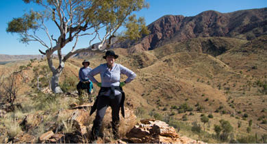
Meeting friendsSo easy – another rest day! A nearby small hill we dubbed Mount Tit, which looked just like Didthul (or Pigeon House Mountain near Milton on the NSW south coast), rose
just behind the camp so we scrambled to the top to view the country buttressing the range. It was an ancient landscape with small valleys and bumps for hills in between; again appearing much smoother than it really was underneath. Having been told about the source of the water further up the mountain, we spent a few hours just milling around the deep pool which was perched at the edge of the mountain. The sun struck the water in sharp laser like beams showing us its mass of colours from obsidian to aqua to teal. As always, there was a signature white gum starkly contrasting with the black pool below it. We could see there would have been other pools above this one but we were content to just sit and absorb this rare site, amazed at seeing sundews (Drosera) around its edges.
Helen and Michelle on Mount Tit with the Chewings Range looking west towards Mount Giles

That night, another party of walkers pulled in to share our camp. Within minutes, I recognised the group from a walk I did in 2020 on the south western tip of Tasmania and of course all the memories of that time were rekindled and raked though. We tried to calculate the odds of this but, of course, with both groups exploring remote parts of Australia, it’s hard to see the meeting not happening at some time.
Ormiston Creek and Mount GilesAnother very cold night and crisp morning found us up and out, heading for the next waterhole along the range; the spring below Mount Giles, the tallest mountain in this range. The valley we followed was just wonderful and rewarded us with a rare sighting of a wild
dingo. When we arrived early at the spring, the thought of camping off the mountain and down in the sands of Ormiston Creek was compelling so we loaded up with our overnight supply of water, about 4-5 litres each, and stumbled down a ridge to the dry creek bed, about two kilometres from the range.
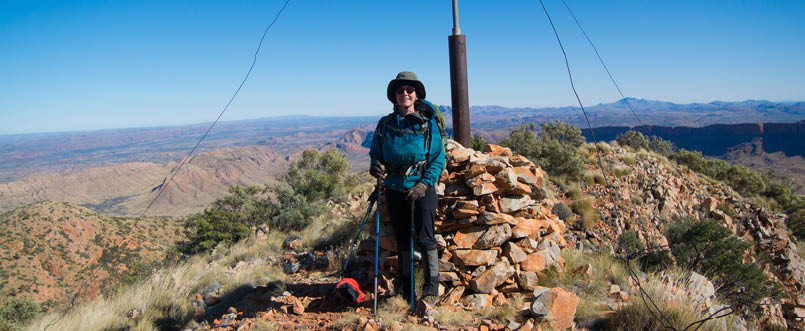
The prospect of climbing Mount Giles was always going to draw us back and, at eight the next morning, two of us slipped out of the camp and retraced our steps to the base of the mountain. We had been looking at the ascent ridge the previous day and wondered if the climb was possible as every angle looked covered by shiny, slippery rock cliffs. Now we faced finding a way and surprisingly, each
Portals Canyon
21
new awkward looking section above us was avoided by some neat groove in the rock. We couldn’t imagine carrying packs to the top, as we knew the first walking group had done several days before. And then they camped at the top in a howling gale – not appealing.
We were amused, on reaching the top, at the ingenuity of the surveyors who had placed an empty, 44-gallon drum on top of a tall steel pole to serve as the trig station for sightings. But then, taking our time and looking around, we saw the magnificence of this country. Way into the western distance we could see the caterpillar range at the back of Glen Helen Gorge with its characteristic coloured stripes. To the north west stood the dark walls of the Ormiston Pound and Bowmans Gorge and to our south lay the string of hills upon which snaked the Larapinta Trail.
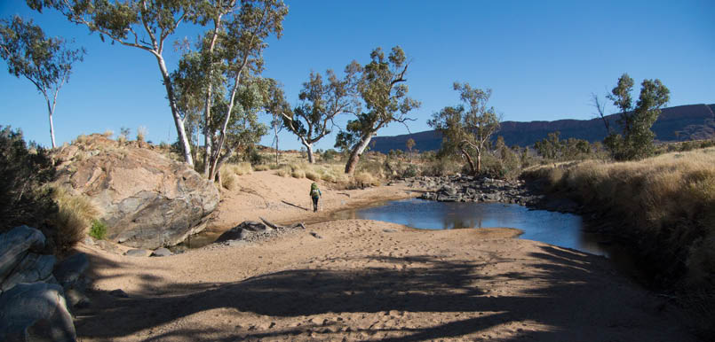
Journey's endLast day! We had planned to head down Ormiston Creek until it met the route, not a trail, which ran from Mount Giles to Ormiston Gorge. All the way down the creek we kept bumping into small remaining water holes which had dying fish. We found out later that these would have filled the creek during the heavy rains, and then die off as the water recedes. Branching off from the creek and heading west, we could now make out the undeniable shape known as The Elephant.
This stayed with us for the next few hours as we, again, were faced with ups and downs of jagged streams which crossed our path, leaving sometimes deep incisions in our way. And did I tell you about the rocks? No walking in this country is easy with the toll placed mostly on one’s trusty boots. Mine had already started to come apart several days before and were now being held together with tent repair tape and some very strong Elastoplast. Sadly, I would consign them to the bin on returning to Sydney.
We reached the tourist track which loops around Ormiston Gorge at around two, totally surprising a group of day walkers, who couldn’t understand where the hell we had come from, certainly in the state we were in. One of our group, Frank, had decided that the cafe at the Gorge served hamburgers and as well, the kitchen closed early. With the absolute desire of a gold digger, he turned onto the track and fled up and over the hill. But it was all too much – just before the cafe he collapsed, desperately calling out ‘get me a hamburger Wildman’. Of course, as I moved unwaveringly on, I was not going to spoil the thought of such a beautiful place by indulging in city, fat-inducing, take-away food. So I bought a focaccia instead, complete with anchovies, salami and mozzarella. What did I say about remote walking?
Helen on Mount Giles with the sheer walls of Ormiston Poundin the middle distance, and Mount Ziel on the skyline
22 | Bushwalk October 2022
We stayed at Ormiston, collected our food container with the next four days’ supply of meals and nick nacks and then cruised on down the trail over the next few days to Redbank Gorge, the end of the Larapinta. We tried to climb the second highest peak, Mount Sonder, but got to within one hundred metres of the top and piked out as the wind was screaming. But what did we care? We’d already had an experience on Giles which we would probably never repeat, and never forget.
So to that question of walking on the set trail or ploughing our own way through open country; in the end I have to say that while the Larapinta is wonderful for information –
Pool on Ormiston Creek en route to the Gorge
milestones, data on the track, designated camping spots – and makes the country accessible to singles, both male and female, it just doesn’t have that edge, that elemental risk factor in not knowing where you are going to go and where you will end up. We also saw much more wildlife on the off-track portion of the walk as well as more wild flowers. In the end it is a much bigger gamble walking off track in this area and requires much, much more planning and preparation. But if this is done, the rewards are much greater – it’s just wild and exciting!
Practical Notes on Walking in the ChewingsMapsThere is a 1:100,000 set of two maps which covers the Larapinta Trail from end to end and we used this for the section from just west of Ellery Creek in the Chewings to Ormiston Gorge. The Department of Defence has 1:50,000 maps of the area closer to Alice Springs and I was able to download these free and load them up into my computer mapping software. But, to be honest, the 1:100,000 maps are quite okay for this country even though they are nowhere near as clear as normal 1:25,000 topographics.
"
... it just doesn’t have that edge, that elemental risk factor in not knowing where you are going ...

23
GuideGiven I didn’t know a thing about the Chewings before we started, I relied on the brief notes supplied by John Chapman on his website. A big thank you to John for his help. Once you started getting used to this country and what was possible or not possible, you can often venture a lot further than John’s notes suggest. The other groups we met had been to the area on previous occasions and knew of gorges, canyons and safe routes down off mountains which are not marked on the maps at all. In fact, there is virtually nothing marked on the West MacDonnell Ranges maps and it would be essential to
at least have knowledge of the permanent waterholes if you want to walk here. There is no substitute for research on this area.
Essential equipmentIt gets cold during the walking season, as well as hot. You will need a good tent and it doesn’t matter if its free-standing or not. Good boots are essential as this country will tear them apart. Fly nets, which we didn’t use, would be important during normal years. We took walking poles and they are recommended here. Carry water containers (like Platypus bottles) for when you need to camp away from water. Layered clothing is important, ensuring that you carry enough for the cold including headgear and gloves.
MealsThere were four of us and one of us prepared all the food for all our dinners. Most of the meals weighed around 550 g for four people with the heaviest being 720 g. We used a

Looking back down the Larapinta near Ormiston Gorge
"
... there is virtually nothing marked on the West MacDonnell Ranges maps ...
24 | Bushwalk October 2022
combination of dehydrated food and vacuum sealed ingredients. We had a lot of variety from curries, to laksa, to noodles to pasta and some Chinese dishes; all interesting and nutritious. It is worth taking the time to
prepare good meals that you can cook over the camp cooker in a short amount of time. In our case we were preparing meals 6-12 months in advance.
Frank on the Larapinta between Finke River and Rocky Bar Gap
Our camp on Ormiston Creek with Mount Giles in the background

25