

The Royal NP is a coastal park that sits on the southern end of Sydney. It became “National Park” in 1879, and is generally recognised as the world’s second oldest national park after Yellowstone in the USA. In 1955 it was re-named to Royal NP after the Queen Elizabeth II passed through the area on her 1954 visit.
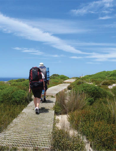
The Coast Track is the park’s most famous track and is a great way to explore a variety of bushland along the coast. The walk follows the coast, heading south exploring beaches, rock pools and amazing views out to the ocean all the way from Bundeena to Otford. At the southern end of this walk you pass through a series of depression-era villages which add a very unique vibe to this walk.
Grade: 4/6 HardTime: Two days (although it can be done in one day if you have a solid pace)Distance: 27.4 kilometres one wayAscent / descent: 1350 metres ascent / 1240 metres descentConditions: Mostly exposed to sun, wind and rainTransport: • To the start: Catch a train to Cronulla then ferry to Bundeena. The small ferry run about every hour. • Back home: There is a train station at Otford, rains about every hour back to Sydney. • If you drive there parking is free at each end of the walk, but there is a park entry fee for Royal NP for the Bundeena end.GPS of start: -34.0827, 151.1511GPS of end: -34.2108, 151.0056
THE COAST TRACKRoyal National Park - Track notes
Matt McClelland (aka Wildwalks)

12 | BWA December 2013


0 km From Bundeena Ferry, on Brighton St, turn left into Loftus St, walk past Mary St and turn right into Bour-nemouth St. Turn left into Scarbourough St and take the first right into Beach-comber Av. Stay on Beach-comber Av until reaching the entry into the Royal National Park, marked by several large information signs.
Bundeena
Bundeena is a small township at the northern end of Royal National Park and the southern side of the entrance to Port Hacking. The town can be accessed by car or ferry. There are a few B&Bs and other accommodation options and a number of cafes to choose from. Bundeena has a mixed atmosphere, partly a beach holiday community but also home to some perma-nent residents. There are two main beaches - Hordens Beach to the west and Jibbon Beach to the east. Both are nice beaches inside Port Hacking.
1.6 km Continue straight from the end of Beachcomber Av, walking around the locked gate, following the Coast Walk sign along the wide manage-ment trail. After about 50 metres, you pass a track (on the left) and continue until coming to an intersection with a wider sandy trail Continue straight follow the asphalt management trail heading towards the green signposts nearby, where you come to the signposted intersection of the Coast Track.
1.8 km Turn left following the Coast Track signpost along the wide, sandy bush track as it winds through the short, thick scrub for almost 700m before arriving at the coast, where there are great views across the South Pacific Ocean.
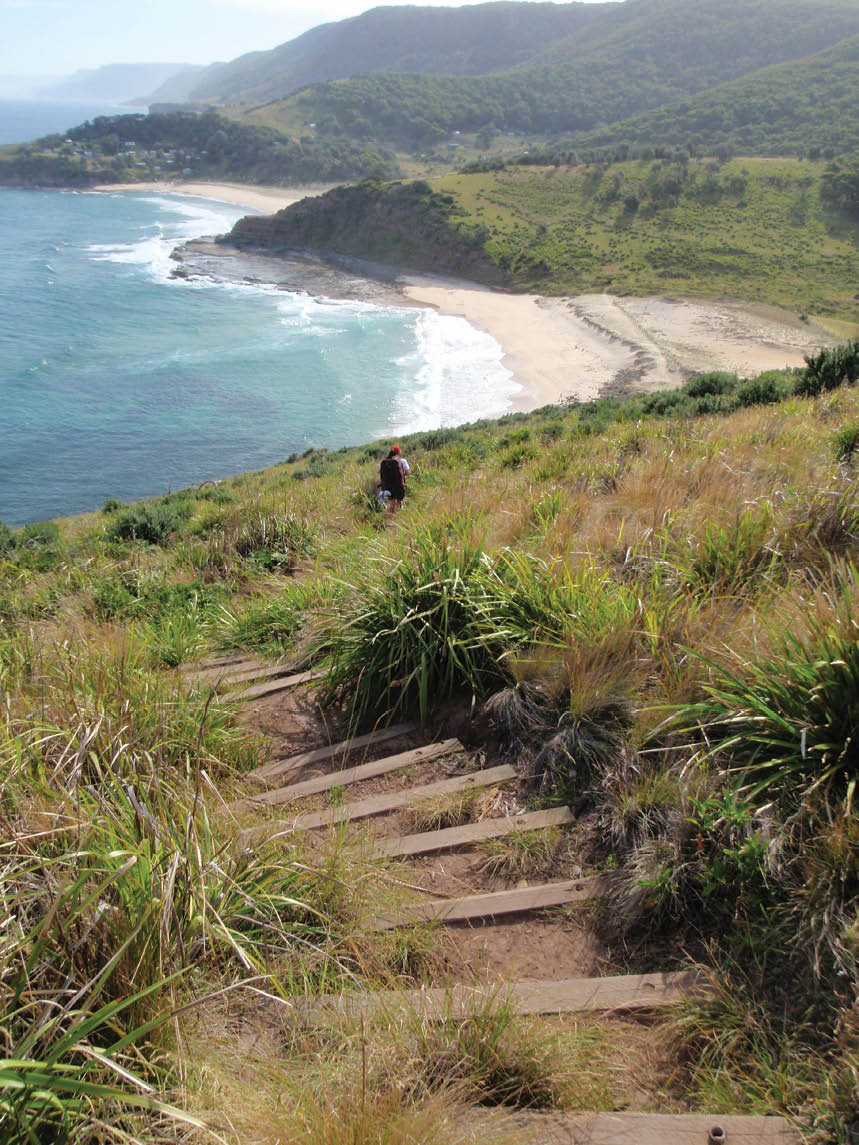
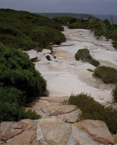
2.4 km Turn right, following the bush track winding south along the coast line, keeping the ocean to the left as you wind in and out of scrub and across several rock surfaces. On a few occasions, the track will split into two and meet up again a short while later - just stick to the track closer to the coast. Follow the track markers until coming to a large gully, where it winds to the bottom via some steep rock steps. Once at the bottom, the track cross the small stream at the wooden bridge and continue up the other side of the gully, climbing up the wooden steps and the hardened path to the top. From the top of the gully, the track continue along the path heading through the high heath for about 1.5 kilometres, until coming to an intersection with a management trail. This intersection is marked by a signpost saying Coast Walk. Veer left, as the track winds down the 450 metres long hill to the end of Marley Beach, where you come to a large green information sign. Continue straight along the beach until coming to the rock-shelf at the far end. Marley Beach is very beautiful and, on a warm day, it would be a great spot to wet the toes. On the rockshelf at the end of the beach, there are some shady spots.
6.3 km Veer left walking up and along the rock-shelf to following the coast as the bush track weaves in and out of the short heath for a short while. After about 200m the track comes to an intersection with an unmarked bush track (on the right). Veer left and keep walking with the ocean and the cliffs to the left. The track winds down the hill for a while before coming to the end of Little Marley Beach.
Little Marley Beach
Little Marley Beach, Royal Nation-al Park, is a yellow sand beach, approximately 140 metres long. The narrow beach faces north-east and has a rock platform at either end. The beach is not patrolled and has no other services.
BWA December 2013 | 13


7 km Continue straight From Little Marley Beach, following the coast across the beach, keeping the ocean to the left as you climb up the sign-posted track at the end to the clifftop. From here, the track follows the coast line for a short period be-fore passing over a bunch of short metal walkways. The track continue through the health, with short periods where you come back onto the rockshelf above the cliff, until the track changes to purely being a clear track through the high scrub, as it winds along to the sign-posted intersection. Veer left as you walk along this track, heading down the long hill through the tall health for about 700m down through some rocks, as it approaches the small swimming hole made by the dam in Wattamolla Creek.
Wattamolla Dam
Wattamolla pool (or dam), Royal National Park, is a small water hole on Wattamolla Creek, above the lagoon. The pool is on the Coast Track near Wattamolla picnic area and offers a quiet spot for a dip and a rest. The pool is formed by a small, constructed sand-stone dam and fed by a small waterfall above.
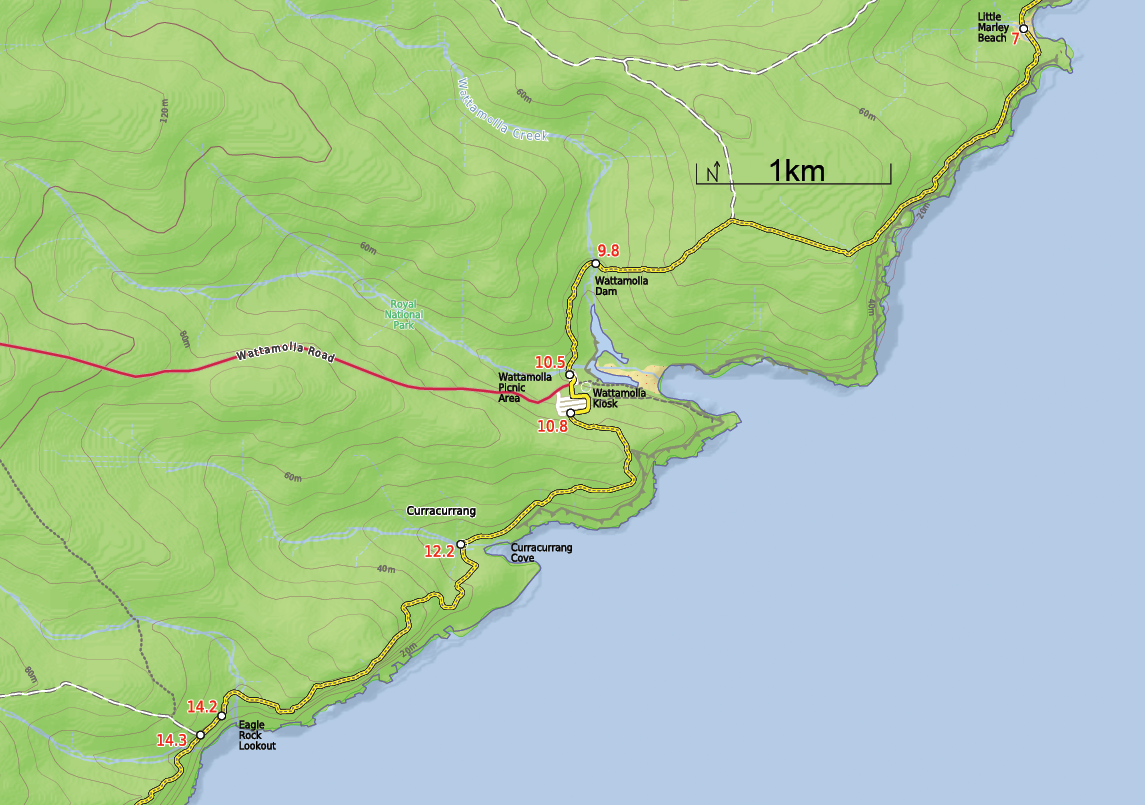
9.8 km Continue straight crossing the creek (which may become impassable after heavy or prolonged rain), to walk about 600 m along the clear track as it leads back into the tall scrub and heads down the long hill until crossing the wide, shallow creek. On the other side of the creek you will find the Wattamolla Picnic Ground and car park.
10.8 km Turn left to follow the management trail climbing up the long hill. walk past two large water towers as it continue along for a while, before coming to a great lookout over the ocean, marked by a sign saying Curracurrang. From the lookout, continue along the cliff edge, keeping the ocean to the left as it follow the bush track. The track winds along the coast to Curracurrang Cove, where there is an intersection with another bush track that head up and away from the ocean.
10.5 km Continue straight From the north-ern end of the picnic ground, walk for about 180 m through the car park and across the grass to the toilet block. Turn right to follow the signs to the Overflow Car Park. At the back of the car park you will find an intersection with a large management trail, with a gate and signpost saying Garrie 5.8 kilometres.
12.2 km Turn left as the track leads you up out of Curracurang Cove and continue all the way up to the top of the large hill, winding through the thick heath across the top and down the other side to Curracurang Creek at the bottom. After crossing the creek, the track follow the bushtrack heading up short hill and along the bushtrack winding through the scrub for a short while before coming to the Eagle Rock lookout at the information signpost, about 2 km from Curracurrang Cove.
Wattamolla Kiosk
The Wattamolla Kiosk in the Wattamolla Picnic Area provides basic supplies for day visitors. The kiosk does not keep strict hours and opens depending on weather and demand. It usually opens on weekends at around 10:30am and closes between 4 and 6pm. You can buy ice-creams, drinks and some hot food. For more information, call Audley Kiosk on (02) 9521 2240.
Wattamolla Picnic Area
Wattamolla Picnic Area is found at the end of Wattamolla Road, about halfway along the coastline of Royal National Park. The area is blessed with a great beach, a lagoon and some wonderful creeks and rocks to explore. The small beach faces west and is tucked away in a deep bay. The lagoon sits behind the beach and is lined with sand on one side, and cliffs and rocks on the other shore. The picnic area has large open grassy areas, with some shade provided by trees and some picnic shelters. There is a small kiosk, toilets, electric BBQs and two car parks. There is water here, but needs to be treated before drinking. There is a gate on the road that is locked at night, the gate is open from 7am to 8:30pm.
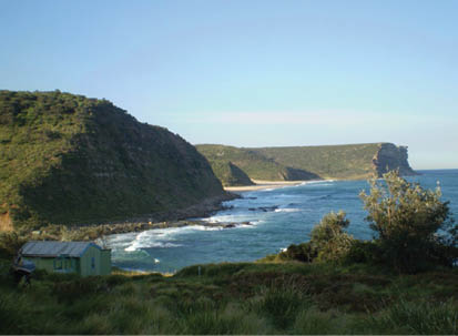
Curracurrang Cove
Curracurrang Cove is a small cove about one kilometre SW of Wattamolla, on the coast of the Royal National Park. The cove faces east and is where Curracurrang Creek meets the ocean. The creek, the cove and the surrounding rocks provide great scenery, making this a relaxing place to stop and enjoy. There is evidence that Aboriginal people lived in this cove. There are a few middens in the area, some rock shelters and Curracurrang creek provides a near-per-manent water supply. The cove was first occupied 7500 years ago and was used as a regular campsite by the Dharawal people.
Eagle Rock Lookout
Eagle Rock lookout is an informal lookout marked by an information sign on the Coast track in the Royal National Park. The lookout is about halfway between Garie Beach and Wattamolla. Eagle rock is a piece of the cliff line that looks amazingly like the head of an eagle, with the eye and all. The lookout is about 150 metres west of the Eagle Rock on the other side of Carracurrong Creek. Eagle Rock is often used as an icon for the Royal National Park. Carracur-rong Creek also forms a waterfall into the ocean nearby.
14 | BWA December 2013
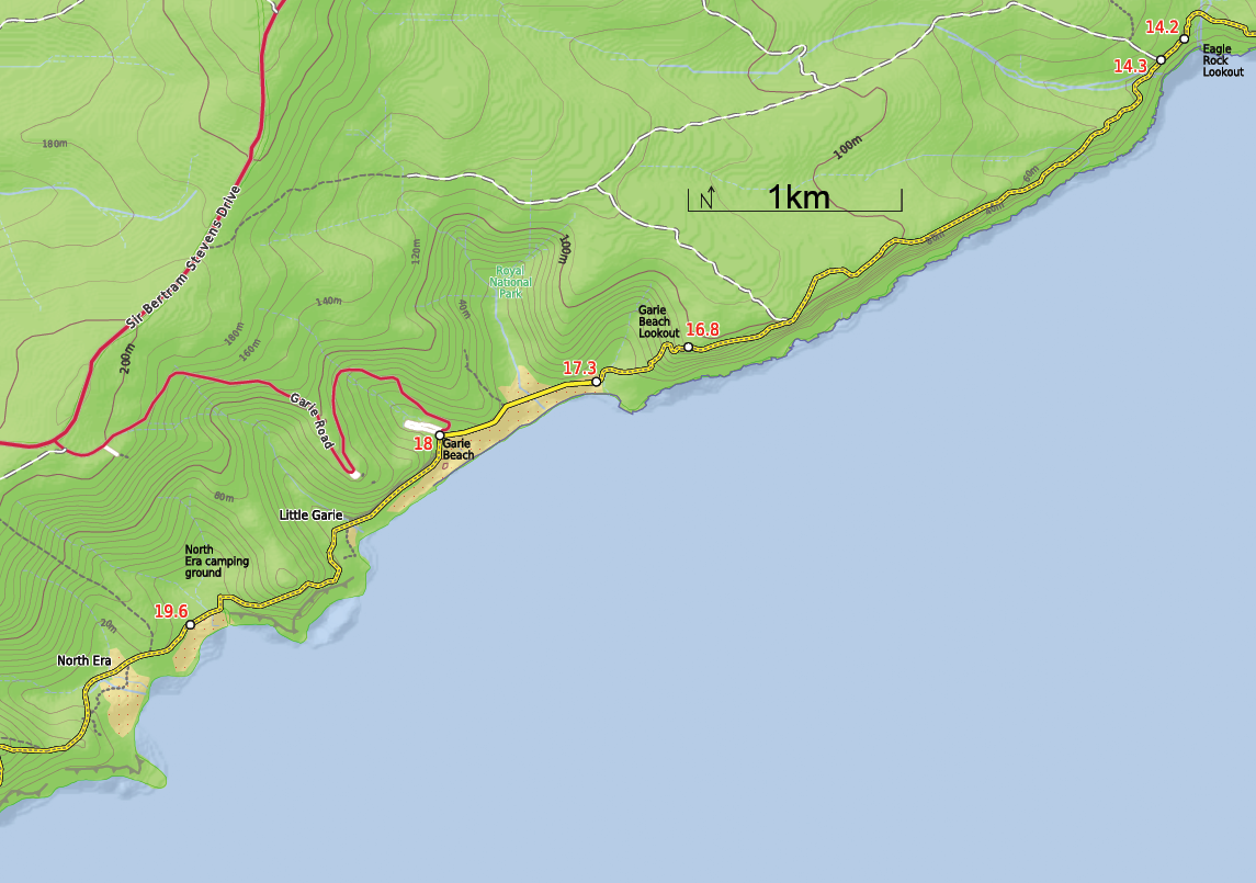


14.2 km Continue straight, keeping the ocean to your left as the track leads through the heath for about 150 m to intersection at the end of a management trail
14.3 km Continue straight walking along the track and the rockshelf, keeping the ocean on the left. For the next 2 km track leads through the scrub and acroos more sections of metal walkways untill coming to an intersection with another track (on your right). Continue straight follow the track around the left-hand side of the Curra Moors car park sign, following the cliffs tops. After several hundred metres of high scrub, the track emerges out into the opening which has fantastic views of Garie Beach and the hills to the south.
Garie Beach Lookout
Garie Beach Lookout is an unofficial lookout on the hill at the eastern end of Garie Beach. The lookout has no facilities and is simply a spot on the Coast track. The lookout provides great views looking southwest along the coast along Garie Beach, Royal National Park and down to Wollongong.
16.8 km Continue straight along the track as it leads for 500 m to Garie Beach, winding down the long hill, descending the steep rock and wooden steps to the bottom of the hill where continue through the grassy clearing to the end of the beach.
17.3 km Walk along the beach for about 650 m to find the Garie Beach car park on your right. About half way across this beach walk you pass a track (on your right) that once lead up to a youth hostel that burnt to the ground at the end of 2010, shame it was a great place to overnight.
Garie Beach
Garie Beach, Royal National Park, is a large, south-east facing, yellow sand beach. The beach is backed by steep headlands and gullies. There is a large car park at the end of Garie Road for access to the beach. Garie Beach is popular for surfing, patrolled 9am-5pm from December to January. Facilities include toilets, kiosk, picnic ta-bles, cold showers and Surf Life Saving Club. The water from the shower should be treated before drinking, this water comes from a tank should not be relied on.
18 km From the Garie Beach car park, follow the sign to North Era, walking along the beach whilst keep-ing the ocean to your left. This track soon follows the base of the large grassy hill between the rocks and the ocean, to the Little Garie cabins and up past the Little Garie Community Hall. Continue straight past the hall heading steeply up the hill, with a series of wooden steps. From the top of the ridge, the track now leads down the other side to wind down into the clearing and the signposted North Era Bush Campground.
North Era camping ground
North Era camping ground, Royal National Park, is a large dune area situated directly behind North Era Beach. This camping spot is popular with surfers, and it also has a toilet and a cleared area to pitch your tent. A maximum of 36 people (12 sites) can camp here, so there is plenty of room for everyone. Open fires are not permitted, you can carry a fuel stove for cooking. A camp-ing permit is required from NPWS before arriving (Phone:(02) 9542 068). Water is often available from the creek (treat before drinking), If dry you can walk to Garie Beach for water, although the water here may also be dried up, during a dry period it is best to carry all your water with you.
BWA December 2013 | 15
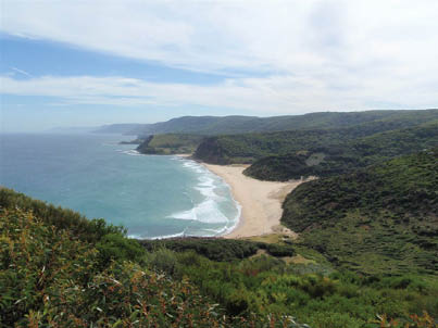

Looking down on Marley Beach from Marley Head
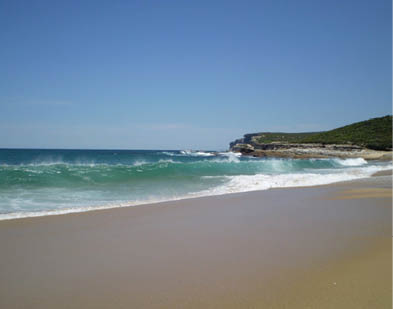
The surf at Marley Beach
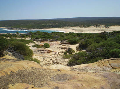
Looking north back along the beaches
Looking at Garie Beach and the coast from the north
The cliffs from the southern headland of Marley Beach
Climbing up to the southern headland of Marley Beach
16 | BWA December 2013
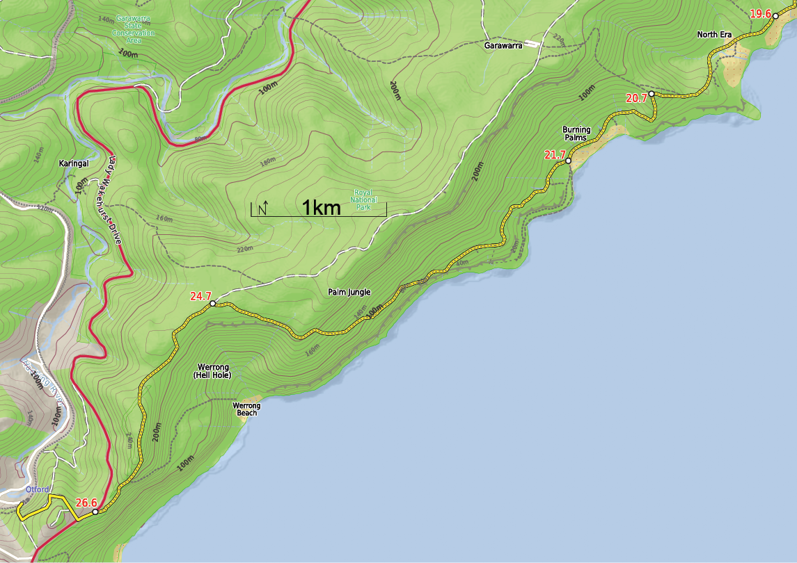


19.6 km After a relaxing night Continue straight walking up the grassy hill, keeping the ocean to the left. After about 200m, just before the buildings, you come to an intersection with a track (on your right). Continue straight over the ridge and down the hill as the track winds down between the cabins to the beach at the bottom. Walk around the back of the beach then up between the houses to the large clearing before the top of the hill. Here, comes to an intersection with two rough bush tracks towards the top of the hill. Continue straight walk up the hill and through the ferns, heading up and away from the cabins but still keeping the sea to your left. Continue to a large Coast Track sign.
20.7 km Turn left follow the sign to Burning Palms along the track, winding down the side of the hill, past the cabins, then at the bottom the track joins onto a metal walkway that soon changes to a narrow bush track. Walk behind Burning Palms Beach until coming to a sign saying Otford via Palm Jungle. (If time and ocean conditions allow check out the side trip to Figure Eight pools on the rock shelf shelf south of burning palms beach).
21.7 km Veer right near the rangers hut, following the Otford sign-post along the clear track up and along the coast. After walking for nearly 900m through grasslands, you come to a very faint intersection just before the dense palm jungle. Continue straight following the track heading up into the palm jungle. After entering the jungle, the track is quite clear but in some places there are obstacles, such as fallen trees and branches. The track continue for about 2km heading inland and climbing steeply up to the top of the large hill. At the top, the track flattens out and head towards the ocean, to arrive at an intersection with a management trail. At this point there are several signposts pointing towards Otford and Carawarra Farm.
24.7 km Turn left to follow the Otford arrow down the management trail, as it winds through the bush till it narrows into a track. From here, the track leads you along through a beautiful section of ferns, then gradually leads you down until reaching an intersection marked with a signpost for Werrong Beach. Continue straight follow the main track, winding down the hill for a short while before coming to the fenced edge of the cliffs. Continue along the track as it winds down the hill leading away from the view then down some wooden stairs to a car park signposted as Otford Lookout.
26.6 km Veer left following the Otford Station sign along Lady Wakehurst Drive to soon meet Fanshawe Road. Turn right onto Fanshawe Road and walk down the long hill to the intersection of Station St. At the intersection, turn left and continue along the road, passing intersection to the T-intersection of the next dirt road. Continue down the hill following the Otford Station signs down the steep concrete path, and down the steps to the station. -- Well done :)
Tips:
Make an early start for day two, it is bigger than it appears.
Finding fresh water can be an issue in summer. If in doubt carry enough for your needs, or leave a water cache at Garie Beach.
BWA December 2013 | 17