,_and_poached-egg_daisies_(white).jpg)

The vegetation growing in spring along the walking trail by the wetland - pigfaces (pink), and poached-egg daisies (white); Banrock Station
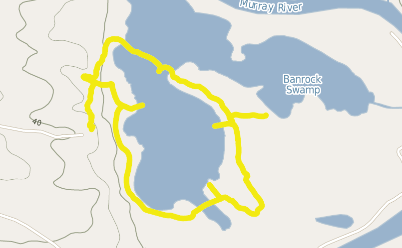
Distance 9 kilometres including side-tripsWalking time About two hours, or a more leisurely three hoursRegion Riverland, South Australia, near the Murray RiverStarts Banrock Station Wine and Wetland Centre carparkWaypoints Wine and Wetland Centre, Shelduck Hide, Chat Hide, Swamphen Hide, Sandpiper Hide, Black Swan HideWalk April 2014

Banrock Station Lagoon WalkChris Jones

36 | BWA October 2015
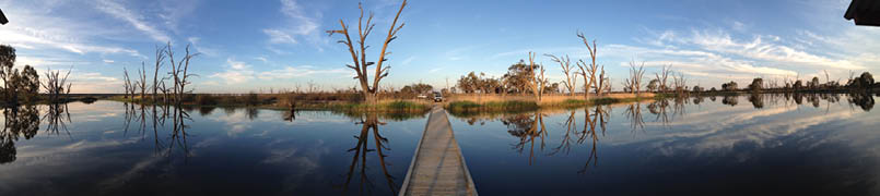
Reflections from the boardwalkBanrock Station
Wine tasting, bird watching, boardwalks through swamps, and floodplain walking – Banrock Station has something for nearly everyone. The walking trail is one of the 40 Great South Australian Short Walks.
Bird watchers will enjoy the number one bird diversity site in South Australia. With the lagoon filling, you are likely to see lots of species including the Australian Shelduck, Pacific Black Duck, Black Swan, spoonbills, several species of herons and cormorants, and even some rare species like the Musk Duck or the Blue-billed Duck. The rare Regent Parrot can be seen flying above the vineyard and Black Box woodlands that fringes the walking trail.
The walk is on access tracks, paths, and boardwalks with mostly easy gradients and is fairly flat. Surfaces are dirt, sand and wooden boardwalks. The walk can be completed in two hours, but allow three to spend time in the hides and enjoy the scenery.
Banrock Station is 212 kilometres from Adelaide. Drive north and east along the Sturt Highway (State route 20) towards the Riverland. Cross the Murray River at Blanchetown, and pass the
turnoffs to central Waikerie. Drive another 29 kilometres. There’s a sign to Banrock Station on the way, and one on the left turn onto Holmes Road.
If approaching from Renmark/Berri/Bamera, there’s a large sign just before Cobdogla showing time and distance. From where the Loxton Road meets the Sturt Highway outside Kingston-On-Murray, drive 5.4 kilometres north-west to the sign-posted right turn at Holmes Road.
Drive along Holmes Road for 150 metres before turning left into Banrock Road. Enter the property (marked with two rammed earth pillars) and continue 1.5 kilometres to the carpark. Go into the Wine and Wetland Centre where you can get a meal and some bottles of the local drop. There are fine views over some of the vineyards and the lagoon.
You need to sign in to walk on the estate, and indicate if you intend to go on a short walk to some of the hides or a long one around the lagoon, described below. Walks are not allowed on days above 35°C and/or CFS classified extreme fire danger days. There is a gold coin donation box.
The lagoon sights will vary depending on the water level, which is artificially controlled. The level varies from empty to full to simulate
BoardwalkCredit to Banrock Station
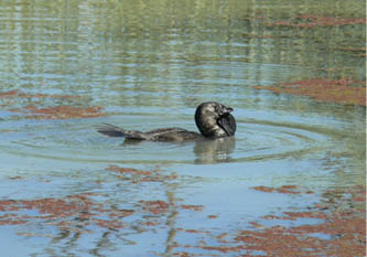
Male Musk DuckCredit to Banrock Station
“Bird watchers will enjoy the number one bird diversity site in South Australia
BWA October 2015 | 37
Banrock Station Floodplain by Chris Jones
natural flooding, encouraging growth of native plants including river red gums, controlling the numbers of introduced fish (including European Carp), and encouraging native animal breeding. Major natural floods submerge the whole area, including the paths.
From the main building, descend the path down the slope past a field of vines. After a short distance you will pass by an enclosure
where one of the Australia’s rarest plants, the Spiny Daisy, has been reintroduced. The daisy was discovered by the Burke and Wills expedition and was thought to be extinct for 80 years! Then you go through a gate in a perimeter fence that keeps out feral animals. You can then go down a fairly direct route to the floodplain, or left along some gullies that come back towards the lagoon. Exit the last gully, going left on one of the paths. This continues to an access trail for a short while, and then turn off towards the lagoon.
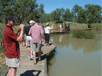
The path then turns into a boardwalk over the lagoon area for about 500 metres with four minor bends along the way. The first section is fairly open, with surface water plants and some open water sections on either side. Reeds then build up, along with water tolerant trees. Shortly before the end of the boardwalk there’s a short track to the Shelduck Hide. This looks out onto the open lagoon, and plenty of birds can be seen from here, including those mentioned above.
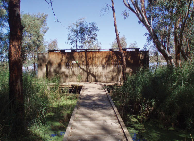
Approaching Shelduck HideChris Jones

BanrockCredit to Banrock Station
“... one of the Australia’s rarest plant, the Spiny Daisy...
38 | BWA October 2015
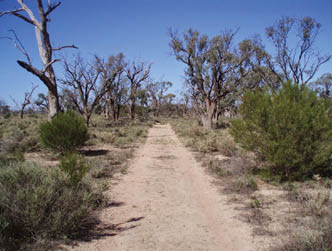
The boardwalk ends shortly after the this, and the path continues at a gate into the flood-plain zone. This is generally drier and with less vegetation than the lush wetland zone. A pole indicates flood levels of the recorded floods, with the highest flood (in 1956) being metres above my head. After 400 metres or so, a 300 metre track leads left to the Chat Hide, which looks out to another lagoon. The water level here was fairly low when I visited, but it was enough for a flock of ducks. A short track leads to the Swamphen Hide with views over the main lagoon.
The path then drops a little to the river zone. While the river is still not visible from here, there are some inlet pipes at the start of the zone. The path here turns down the other side of the lagoon. After a short distance there’s a track to the Sandpiper Hide. After this there’s an open section of water with another boardwalk, which goes for about 200 metres.
The path then climbs slightly and goes closer to the fence in another floodplain zone. This goes for about 500 metres until it comes to the vineyard section, part of which is on the other side of the fence. After another 300 metres the path passes through another
gate. Shortly after this there’s a track to the Black Swan hide. After this, walk another 200 metres to the path returning to the Wine and Wetland centre.
Alternative walks
People wanting a shorter walk can go along the main boardwalk to the Shelduck Hide. Bird watchers could spend quite some time there. A walk to the Black Swan Hide is also worthwhile, but misses the interesting plant and bird life along the boardwalk.
During the dry bed phase (every two years), a dry bed walk is proposed to visitors, giving them another perspective of the place and the opportunity to discover what is happening to the wildlife of the wetland when water recedes and the importance of the dry phase in the ecosystem functioning. This one kilometre dry bed walk from Shelduck Hide to Black Swan Hide follows an easy well-marked trail with interpretative signage along the way.
The assistance of Dr. Christophe Tourenq, Wetland Manager, Banrock Station in the preparation of this article is gratefully acknowledged.
Banrock Station Lagoon Walk map
Banrock Station Wine and Wetland Centre

Black Swan Hide
Sandpiper Hide
Swamphen Hide
Chat Hide
Shelduck Hide


BWA October 2015 | 39