
Butlers TrackRichard Appleton

Following the disastrous 2009 bushfires in the region, which devastated so much of the country around the Strzelecki Ranges and affected so many people in the area, some local people applied for Bushfire Recovery funding to construct a new track.

The Grand Strzelecki Track
Michael Haynes

32 | BWA February 2017
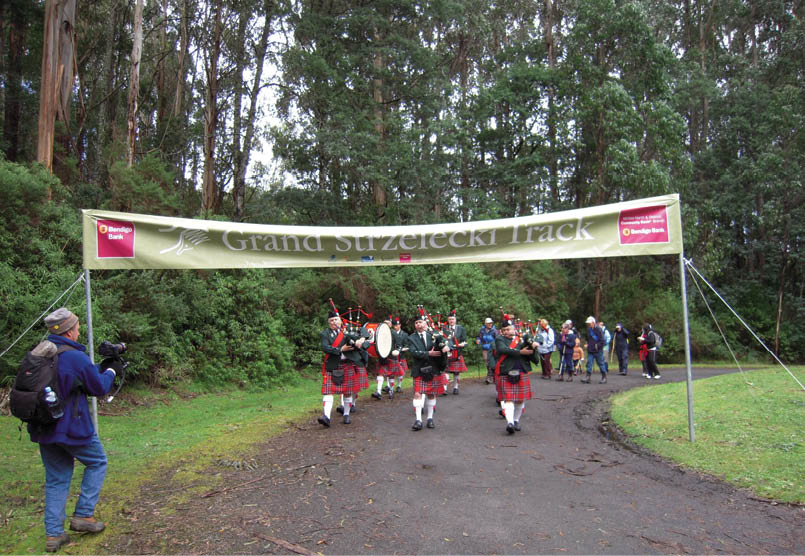
Their aims in creating the track were to provide a boost to the local economy, to add to the sense of community in the locality and to provide a lasting legacy of access to a beautiful, and often under-visited or unknown part of the state. They were successful in their application, and with funding also being provided by other generous sponsors, construction of the track began. This track was the combined brainchild of two groups of visionary local people. One concept was to have three loop trails, centred on and radiating out from the Tarra Bulga National Park. The other was to create a track joining the Morwell National Park in Churchill with Tarra Bulga National Park in Balook. It was to be called the Grand Strzelecki Track (GST), and a committee was formed to oversee its construction.
In 2011 my club was approached by this committee, seeking the input and assistance of bushwalkers. I attended some meetings to represent the club and subsequently joined the GST committee.
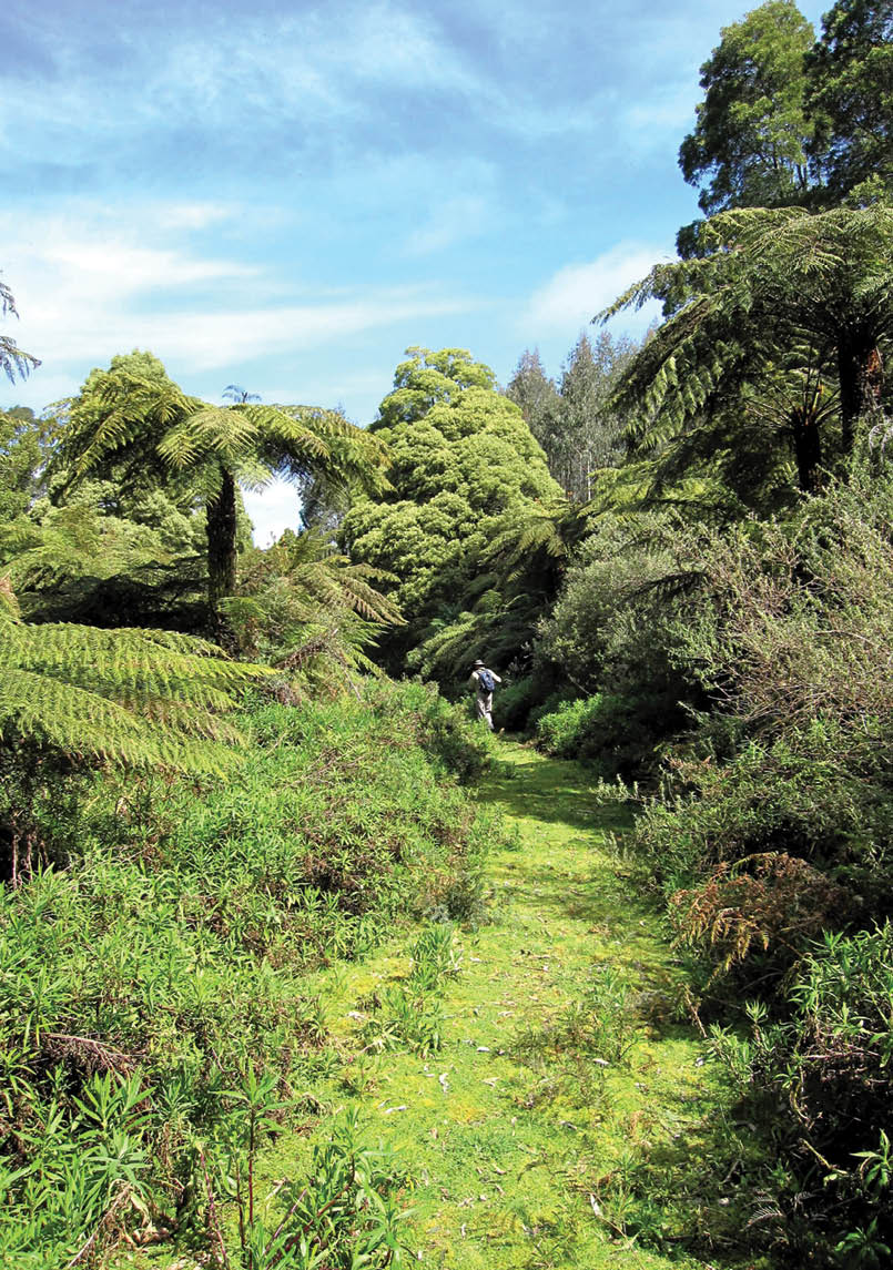
The GST is unusual in that its route includes two national parks and has a great part of its length on private land which is controlled by Hancock Victoria Plantations (HVP). Lengthy discussions took place before permission was granted by HVP for the track to be constructed on their land, but once agreement had been reached they were very generous in assisting us in many ways and in allowing us to route sections of the track over some of their logging access tracks. Where practicable the GST has utilised “Cores and Links” on HVP property, where the company has undertaken to maintain natural bush corridors as access for migrating wildlife. Parks Victoria also permitted us to route some of the GST along sections of their existing tracks, and to put up signs along the way.
The GST is 110 kilometres long, but it lends itself to shorter walks of one or two days, although it is worth doing in one go if time permits, which was how I tackled it as a
Grand Strzelecki Track opening day at Balook, May 2012Richard Appleton
“... its route includes two national parks and has a great part of its length on private land ...
“The route follows Billys Creek upstream through a valley with steep sides, crossing the creek 57 times.
BWA February 2017 | 33
.jpg)
club walk over an extended Melbourne Cup weekend in 2012, although I have also walked most sections several times as shorter walks. As we intended to camp we carried full packs for the first two days. We began at Morwell National Park off Junction Road in Churchill. The first part is very easy, winding along beside Billys Creek until a small weir is reached. Then starts the most challenging section of the GST. The route follows Billys Creek upstream through a valley with steep sides, crossing the creek 57 times. During a dry summer many of the crossings can be accomplished with dry feet if one is nimble, but in wetter times it is necessary to simply
wear old boots or the like and just wade across. A walking pole or two for balance can be very helpful here. The picturesque Billys Creek Falls makes a good lunch spot.
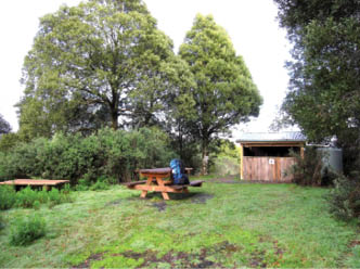
From here the track climbs more steeply, and the lush vegetation becomes even denser. One needs to look carefully for the posts with triangular yellow markers featuring Eric the Echidna to stay on the track. When the track leaves the creek it crosses Road 4 and climbs steadily until reaching the GST camping ground at Jumbuk – a distance of only 13.1 kilometres but taking seven hours or longer to walk! This camp site is only accessible by walkers, and is in a delightful bush setting. It has water, a lovely airy toilet, a cooking shelter with space to pitch two tents under a roof if desired, and a picnic table with seating.
Billys Creek Falls Darryl Whitaker
“... we were woken by bird calls, particularly obvious being two lyrebirds ...
34 | BWA February 2017


After a quiet night we were woken by bird calls, particularly obvious being two lyrebirds giving us their full repertoire of calls. Back on the track we walked through a beautiful fern gully, then traversed a eucalypt seed orchard before joining a quiet 4WD road and passing through 2009 fire regrowth areas until reaching Traralgon Creek. This was the only creek we needed to cross today, so at the stony ford we removed our boots. An easy walk then took us down 4WD roads to a junction with Grand Ridge Road. Here was
our second camp site, at Pattison Rest Area. This is a smaller site, with less facilities – just a toilet, water and a small shelter – but quiet and peaceful. We had walked 13.8 kilometres but this section only needed about four hours.
Over the next three days we walked each of the loops centred on Balook and the Tarra Bulga NP, but because we returned to Balook each night we only carried day packs. We camped at the old Balook school and camp site, but this is now overgrown, although the GST Committee is trying to obtain its use as a joint community and GST site where walkers could camp. Camping is currently available by arrangement in the Balook Guest House grounds, or one can stay in luxury at the guest house itself! The three loop walks are fairly long, so if time is no object each could be done over two days.
Probably the most popular section of the GST is the Mount Tassie Loop. This is 18.3 kilometres and takes about 6.5 hours. It incorporates the Duff Sawmill Heritage Trail, a 3.8 kilometre section which reflects the story of an early timber harvesting settlement, but
Signboard near the start of the Mount Tassie loopRichard Appleton
Jumbuk Rest AreaRichard Appleton
BWA February 2017 | 35
also includes remnant old growth eucalypts, some regenerating rainforest and a beautiful Blackwood forest. The track then climbs to the top of Mount Tassie, where we passed two telecommunications towers before reaching a picnic area. There's a cairn here in remembrance of the bushfires, with panoramic views of the Latrobe Valley and the Strzelecki Ranges. The return track follows some 4WD roads and some newly constructed walking tracks, passing the Forget-Me-Not Falls and the Morningside Grange Homestead site, where camping is permitted, but no facilities are provided. Alternatively, it is only a couple of kilometres from here back to Balook.
The Tarra Valley loop is longer, nearly 23 kilometres. It passes through some spectacular bush before the track divides. For those choosing to break their walk, it is a quick 2.5 kilometres south to the Tarra Valley Caravan Park. Otherwise a turn to the
west (right) takes us past two small waterfalls to join the Tarra Valley Road near what was once the separate national park of Tarra Valley. Here there are toilets, picnic shelters and a short walking path to Cyathea Falls. The track then follows the Great Forest Walk around to cross Grand Ridge Road and wind our way back to Balook.
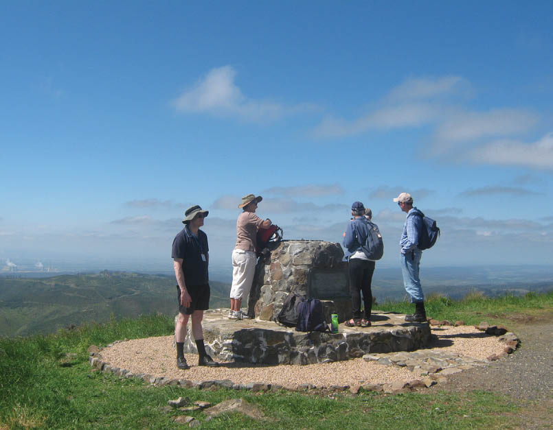
Mount Tassie Rotary cairn overlooking the Latrobe ValleyRichard Appleton

Mossy boulder on Tarra Valley Link TrackSharon Williams
36 | BWA February 2017


Corrigans suspension bridge, Tarra Bulga National ParkSteb Fisher
The longest loop, at 25 kilometre, is Macks Creek, incorporating Wild Cherry Track, and it has four creek crossings where you will probably get wet feet. Camping is available about halfway around at Macks Creek Hall, although there are no facilities here unless the hall itself is hired (see the GST website). The walk back to Balook (when looping clockwise) treats us to some great views out towards the coast, which can be seen on a clear day.
The GST is the chosen venue each year for the Duncan’s Run 100 ultra-running event, comprising runs of 6, 28, 50 and 100 kilometres. The sections chosen by organisers vary from year to year, so runners have a new challenge each time.
The GST has just celebrated the launch of the second edition of their map set, comprising five detailed maps and an overview of the entire track. The maps are available for purchase online, as are some designed for downloading to electronic devices. I would strongly advise anyone thinking of walking the track to obtain copies of the maps before setting out. The Strzelecki Ranges are not particularly high, but snow is recorded each winter, and weather conditions can change quickly, so going prepared with suitable clothing and other gear is very necessary. The GST
is a grade four track, which means it has some challenging sections and walkers are expected to be able to navigate from a map and to be self-sufficient and well-equipped. Letting someone know in writing of your plans before you leave is very advisable.
If any readers are interested, the GST would always welcome more members to their Friends group, and new Committee members are eagerly sought. Contact can be made through the website grandstrzeleckitrack.org.au
Trail postSteb Fisher


BWA February 2017 | 37