
Six years ago I walked the South Coast and Port Davey Tracks, Cockle Creek to Scotts Peak Dam. On the last day I saw the Western Arthur Ranges shining in all its glory under a light dusting of snow. Wow, what a sight that was, a jagged mountain range with all the glacial lakes carved out by the last ice age, it has to be impressive up there. Since then I have been dreaming of a way to return. I so wanted to explore this range - just think of the views to be had. I only had to find some friends that wanted to do this walk with me as it is a tough one.
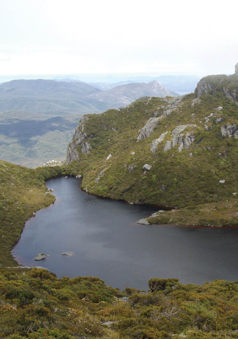
Lake CygnusPaul Every

The Western Arthurs Tasmania With the Warties
Sonya Muhlsimmer

6 | BWA April 2017

Well, it took a while but I got there. I got a team together and we will be known as “The Warties”. Thanks Paul. Great name, it has a real ring to it ... The Warties are Paul, Martin, Chris, Maj-Britt and me, Sonya. Flights were booked and everything else was organised. I even put in an order for the weather to be kind to us so at least we could complete the traverse, as the Western Arthurs are known for violent weather. Just have to wish for the best. Okay, off we go.
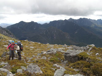
Day 1: Scotts Peak Dam to Junction Creek8.4 kilometres, 4 hoursThe Tasmanian Wilderness Experience bus company picked us up from Hobart airport, and after stopping in New Norfolk for coffee and last minute shopping, we arrived at Scotts Peak Dam around noon. After repacking and some snacks, walking began around 12.40pm. It was a perfect day, the sun was out, the views to the range were fantastic, spirits were high and we were all very excited. It was a relatively easy day's walking, apart from the 23 kilogram pack on my back and walking through the bog ... However, the bog was not that bad compared to when I was here last, but let’s see what it will be like on the way back as it is all weather dependant. We had a few breaks, taking in the sights. This was not
going to be a trip where we rush to camp; this walk was going to be enjoying the sights and sounds of the area. Oh, and waiting for me to get up the hills ... Camp for the night was at Junction Creek, and as we were getting our bearings, looking at the map the sun set over the Western Arthurs. Oh wow, what a beautiful sight. The anticipation is rising. But, let’s hope for good weather for the rest of the trip. Tonight’s dinner is spaghetti bolognaise.
Day 2: Junction Creek to Lake Cygnus7.3 kilometres, 7.5 hoursThe South West teased us on our first day with the perfect weather. It started drizzling during the night, we woke up to rain, and it drizzled and rained most of the day. We set off in the rain and walked along the buttongrass plains till we reached the bottom of Alpha Moraine. Martin's back was playing up and he decided it was best for him not to continue so he turned back. So after saying our farewells we started walking up Alpha Moraine. We trudged up, up, and up little further. We had a break in a cave and the clouds parted just enough so we could get a glimpse of the surrounds, a majestic sight
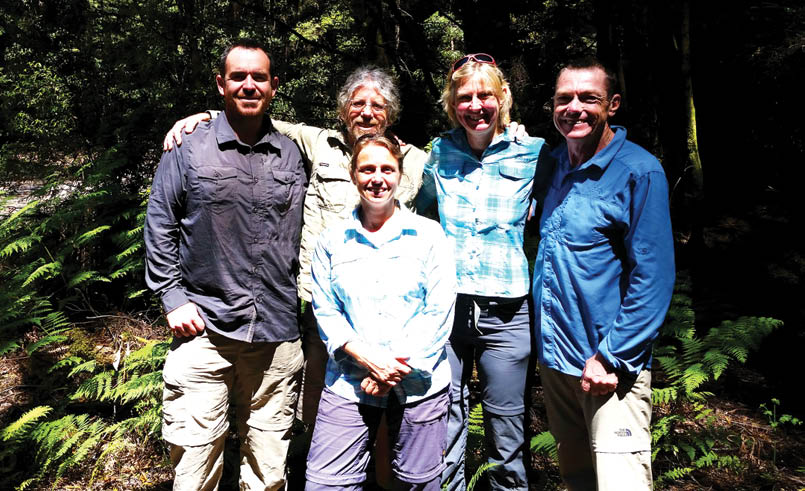
The Warties - left to right Martin Kirk, Paul Every, Maj-Britt Engelhardt, Chris Riley and me, Sonya, in front
“I even put in an order for the weather to be kind to us ...
BWA April 2017 | 7

between the cloud breaks. Then I realised that my camera had fallen out of my jacket. It was found in a pool of water under a waterfall, so no more photos from me on this trip. What I found more annoying is that now I have to carry this dead weight for the whole trip.
After lunch we went onwards and upwards, scrambling over rocks to a saddle. The climb was 688 metres over two kilometres distance, steep. At the top the walking was a bit easier, phew. The track continued to a rocky outcrop, Mount Hesperus, and a little bit further the mist dissipated, with Lake Fortuna appearing. Also, on the other side of the ridge you could just see Lake Pluto, with the track continuing to another rocky outcrop Capella Crags. It was misty with a bit of drizzle but the rock formations looked quite dramatic peeking in and out of the clouds, so surreal. So far the track was easy to follow.
In less than a kilometre we were looking down a gully onto the welcoming sight of Lake Cygnus, home for the night. This camp site had a large platform that fits about six or so tents and a few smaller platforms, and one of those fancy toilets that you screw
the cap off, flip the lid down to sit on, then screw the lid back on when finished. It was not the nicest thing to use but it avoids a major problem. After squeezing our tents onto the main platform among other walkers, we were off to explore the area. The drizzle had stopped, the clouds had parted and a pristine lake with a rocky rim was in front of us, absolutely spectacular. On the bay there were quite a lot of different flowers and plants compacted in such a small area and all the shrubs looked twisted and beaten by the harsh climate. But more importantly there was a competition: who could skim a rock the furthest. Back at camp, another walker said a high pressure system was coming through, which means good weather is on its way, let’s hope ... Lamb ragout for dinner.
Day 3: Lake Cygnus to Lake Oberon4.2 kilometres, 7 hoursThere was a bit of cloud in the morning but no rain, a bonus. I was wondering if this was the high in the weather we were expecting. The track started up a steep hill out of the campsite, and the views were spectacular. Looking out over Lake Cygnus you could see for miles south-west over the dam. The
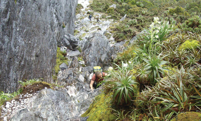
Scrambling out of Lake Oberon, en route to Mt OrionPaul Every
“The climb was 688 metres over two kilometres distance, steep.
“... there was a competition: who could skim a rock the furthest.
8 | BWA April 2017
.jpg)
clouds were parting, with a few stops to take photos, well not me - I just enjoyed the view ... The track was still easy to follow and easy walking but under Mount Hayes the track descended a steep gully with a bit of scrambling. At this section there were a few clouds about and the rock formations looked absolutely mystical again, peeking in and out of the clouds, and scrambling down in the cloud made it even feel more mystical. It was pretty special up there, such a wild and dramatic place. With or without the cloud, every minute the views and surroundings were immense. From here the track went down to a saddle, then small ups and downs and sidling along, pretty straightforward. A morning tea break was declared to check out the views on the ridge on either side as we thought we should see Lake Ceres from here. However, after looking at the map we discovered that we were looking down the wrong gully.
Just looking down these gullies and as far as we could see, the weather and views were spectacular. After our break the track continued up then down and then it sidled around Procyon Peak, oh wow, the views here, the rock formations really take your breath away. Another quick break was declared with the views down to Lake Ceres. Square Lake was less than one kilometre away, and was declared a swim and lunch break. Seems like every set destination is only one kilometre away, but it’s a matter of what is involved to get there that makes this walk tricky!
At Square Lake, Paul and Maj-Britt had a swim and Chris and I enjoyed sitting on a rock in the sun. It was a good, long break. Also, we were building up the stamina to walk up a really steep spur then down a really steep gully into Lake Oberon. The last leg of today’s walk, only about one kilometre as the crow flies, is going to be tough. At the top of the spur on the saddle between Mount Orion and Mount Sirius the clouds came in and Square Lake disappeared, with the track descending a very rough and steep gully. There was some rock climbing and tricky scrambling getting down. But half way down the clouds parted and there it was, Lake Oberon in our sights. This tough little steep gully is absolutely beautiful with the amazing array of plants and rock formations; the views make it all worthwhile. It felt like there should be some Pterosaurs flying around or dinosaurs roaming the fields in the distance, it really felt like something out of this world. The camp site and toilet was hidden in the shrubs and there were a few smaller platforms available. Dumplings for dinner.
Day 4: Lake Oberon, declared rest dayThis was a rest day. After the walk so far it was nice just to relax a bit and take in the atmosphere of this beautiful place. The next two days are the toughest and most challenging part of this walk so a fresh mind and rested body would not go astray. Lake Oberon is the place where some bushwalkers turn back. The scramble down makes some
Lake OberonChris Riley
“... after looking at the map we discovered that we were looking down the wrong gully.
“It felt like there should be some Pterosaurs flying around or dinosaurs roaming the fields in the distance ...
BWA April 2017 | 9


In the cloud at the top of Mt OrionNicholas Hall
people lose a bit of confidence as they know it only gets tougher from here. It sure does ... Or the weather sets in for the worse and it would be too dangerous to continue as there are many more climbs and scrambles to come.
This day was also used as a reconnaissance trip and to take photos of the surrounding views as we would not have time or the energy to take photos scrambling up and down Mount Pegasus and Mount Capricorn. Mount Pegasus looked like a steep climb. We knew there was a scramble at the bottom with a pack haul through a hole in boulders, and that was just the start of the day. During the recce trip, a small tarn was found and the views were as far as the eye could see, over to Scotts Peak Dam (or SW coast) and yonder. Chris commented that you could probably see about 20 percent of Tasmania; he was probably right. Back at camp we had swims, played card games, ate lots of food, drank lots of tea and relaxed. It was not a bad spot at all for a rest day. Laksa for dinner tonight.
Day 5: New Years Eve, wet weather dayDuring the night there was a lot of rain. The alarm was set for 6am but when I looked out of the tent the visibility was, well, non-existent. After discussions, we decided that if the fog cleared by 10am we walk, and if not we stay: it was a hard day and we did not want to risk being caught in bad weather. Visibility was also an important factor in the next leg of the walk. John Chapman’s track notes said: “At times the route is dangerous,
being poised above high cliffs, and it requires many climbs up and down steep gullies. It is advisable to have reasonable weather before leaving Lake Oberon”.
At 10am visibility was nil, and with showers about it meant another day at Lake Oberon. Most of the day was spent in the tents, however in the early afternoon the clouds parted, somewhat, and we took advantage of this break in the weather to climb Mount Orion with Nicolas and a few other walkers. The climb out of Lake Oberon didn’t seem as intimidating, especially without a heavy pack. As we walked up to the summit the clouds reappeared and engulfed us. But on the top the clouds parted just enough that we could see Square Lake.
Back at the tent I started preparing snacks for our New Year's Eve celebration. We feasted on a spread of falafels, hummus, olives, sun dried tomatoes, cheese, biscuits, salami, jerky and red wine then ended with some freeze dried strawberries, dried mangos, ginger nut biscuits, protein balls, chocolate and Baileys. Gee it was good! Then as the sun set we walked out to our favourite rock above the lake and lit sparkles and sent a wish to Martin, wherever he may be. The clouds parted and we could see so many stars (including the constellation Orion) standing out above the natural amphitheatre with its jagged peaks. Words cannot explain how spectacular this place is. An awesome New Year's Eve was had, definitely one to remember.
“At 10am visibility was nil, and with showers ...
10 | BWA April 2017
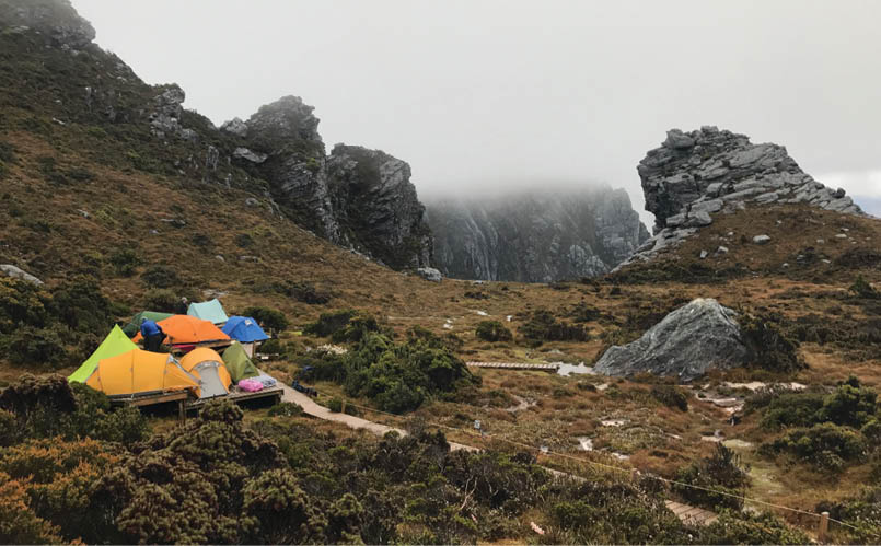

High Moor Nicholas Hall
Day 6: New Years Day, Lake Oberon to High Moor4.3 kilometres, 8.5 hours There was mist in the morning, but off we went, steeply up. I hauled my pack at the first tricky part and then continued up the hill. Near the summit of Mount Pegasus we hauled packs and climbed through the hole, and continued up. Then we went down a steep gully, across steep slopes then down another steep gully, sidling some more slopes. There were clouds about, but I saw a bit of Lake Uranus. Now in front of us was a scramble up to Mount Capricorn, through the drizzle, and only about 1.5 kilometres left for the day.
After the summit there was a down climb and more pack hauling, and then even more steep climbs down through mud only holding onto tree roots and bushes. Interesting manoeuvres when you are short as there were some parts where I could not see, feel or reach anything. Alas, a small cave was found and we had a break. We were all tired, wet and cold at this stage and I was covered in mud. Chris hit his head standing up, he cupped his head, he
was in a lot of pain and there was blood. My first thought was "is he okay?" and "how do we get rescued here on the side of a cliff?" We patched him up, gave him pain killers and luckily he was all right, phew. On we went again down through tree roots, bushes and some more steep muddy scrambles, then up and down and up and down again then up with a few scrambles in between. It felt like the track never ended and I kept thinking this must be like walking into Mordor ... Today’s walk was very long and hard. At camp, other walkers helped get our tents up and put warm cups of soup into our hands. There was an open section for the platform which could fit around eight tents, and further away was the fancy toilet. Chicken soup for dinner.
Day 7: Wet weather dayApparently during the night the temperature dropped to 4ºC, and a resident rat had a ball trying to raid through tents, luckily not mine. Paul woke up with a hole gnawed through the side of his tent and other hikers said they got a visit too. The day did not warm up much either - it was cold and wet and there were no views about. Today was declared a communal tent day, even with the other walkers. We only got out of our tents if necessary. Honey soy and pork noodles for dinner.
“Interesting manoeuvres when you are short as there were some parts where I could not see, feel or reach anything.
BWA April 2017 | 11
.jpg)
Top of Kappa MoraineMaj-Britt Engelhardt
The Western Arthurs behind us nowPaul Every
Day 8: High Moor to Haven Lake3.8 kilometres, 9 hoursWe woke up to mist in the morning and a bit of drizzle. I don’t think this high is coming through in the weather system, but, I guess the Western Arthurs is pretty unpredictable. You just have to take what it gives you, or gloss over photos on the internet. Only a few kilometres today, but, this was the toughest day so far. The track notes say “This route follows a very complex passage through the crags of the Beggary Bumps”. I would say beggary was to kind of a word, however the word I would use to describe this section can’t be posted here ...
The track goes up, down then up again then down again, but sometimes sidling on very steep slopes, literally on the side of a cliff. It was constantly meandering through tree roots, over slippery rocks or down very steep gullies. I lost count at six of the “Bumps” but apparently there are 16. I had to focus on my hands and feet, a lot of concentration; really the day was a blur. The track negotiated through the Tilted Chasm, then up to The Dragon and onwards to Mount Taurus with its many false summits. The rope came in handy for me in many sections, pack hauling and down climbing. This track just goes on and on. It was a cold day with mist and drizzle, we had some views, but not that much. Or was I just concentrating too hard?
Haven Lake was finally reached and lamb casserole was for dinner.
Day 9: Haven Lake to McKays Track 5.4 kilometres, 9.5 hoursToday was our last day on the range. It was filled with relief as we have made it this far without calamity, and melancholy as it is such a majestic place and you just want to keep exploring. The views are immense; they really take your breath away, when you get them ...
There was a bit of cloud about in the morning when we set off. The track leaving Haven Lake was a steep climb to a saddle, then down, then up again.
12 | BWA April 2017
.png)
Promontory Lake in the background, towards Eastern ArthursNicholas Hall
Sonya's two favourite things in life are spending as much time outdoors as possible, and food. From a very early age her father had her out skiing (literally as soon as she could walk), camping, caving, and bushwalking. Sonya is a member of a bushwalking, adventure and canyon group. She has a BSc in Food Science, is also a qualified chef and has written a cook book with lots of nutritional advice designed especially for bushwalking. Her website is xtremegourmet.com.

Once the next saddle was reached, the clouds parted and the sun came out, this must be the high we were waiting for ... Standing on the rocks, and there in all its glory the Western Arthurs were behind us and the next steep descent down to Lake Sirona was in front of us.
This is why we do it, for the views, they were outstanding. The packs came off and we explored this area taking it all in. I think Maj-Britt and I had a teary moment together. Paul stood on a rock looking back at the Beggary Bumps yelling out expletives and Chris was gobsmacked by the views. I would say we were all a bit emotional, and very tired at this moment. The photos don’t do it justice; you have to experience it for yourself.
After the down climb to Lake Sirona our last rock scramble up was over Mount Scorpio which was easy to negotiate with all the cairns. There at the top we had another break looking down at Lake Juno, then another long break at the top of Kappa Moraine. Kappa Moraine descends 200 metres over 300 metres distance, in other words it is steep, and here we did our last scramble down.
Halfway down the moraine we took the shortcut track which reduces the distance to the McKays Track by five kilometres. I don’t think it reduced the time by much, just the distance. The track dropped off after a while but it was not too hard to negotiate with a map, compass and GPS. Camp for the night was on the McKays Track in a soft and mossy forest and gnocchi was for dinner. It was our last night out.
Day 10: Two Mile Creek to Scotts Peak Dam12 kilometres approximate, 6.5 hoursApart from a bit of bog the track out was easy going. Maj-Britt ended up in a bog up to her thigh, and she is pretty tall. She was in feet first. We reached Scotts Peak Dam around 2.30pm with the bus waiting for us and it took us to our accommodation for the night (which is called Base Camp, situated in Glenfern managed by Tasmanian Wilderness Experience). Guess who was there? Martin! What a happy sight to see him again, and The Warties were reunited, a very happy ending. The next day we travelled back into Hobart.
CommentsA huge thank you to Nicholas, Chris, Paul and Maj-Britt for the use of your photos. This was a tough walk, not for the faint hearted but ever so rewarding. The track was easy to find most of the way, but there were a few sections where you have to stop, look around and think about where you're going. I nearly went down a very steep gully as I thought I saw a cairn and it looked like a track, it was a track to nowhere, I nearly got stuck. There are also many false summits. Be warned, there is a fair bit of rock climbing and scrambling involved. However, I feel quite content that I completed this walk. One day, I am sure I will return. Perhaps the Eastern Arthurs next?


“... and there in all its glory the Western Arthurs ...

BWA April 2017 | 13