
Peeking out the window of our room at the Swagman Rest, the Alice, I saw dawn’s first light glowing on the ranges behind us. I had a glimpse of the vivid colours of Central Australia. The Larapinta Trail awaited. Tingling excitement and nerves. Fifteen days of walking through the arid heart, where water is a precious commodity and getting lost is not good.
Simpsons Gap

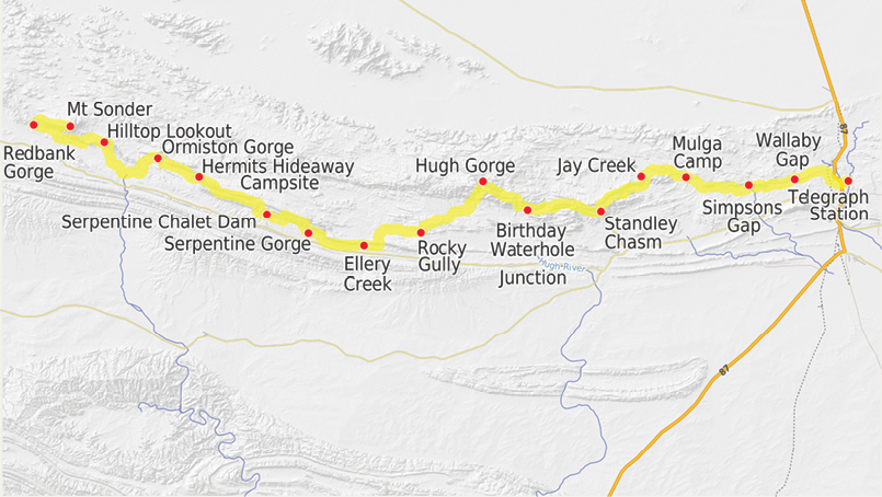
The Larapinta Trail
Gary O'Connor

14 | BWA October 2017
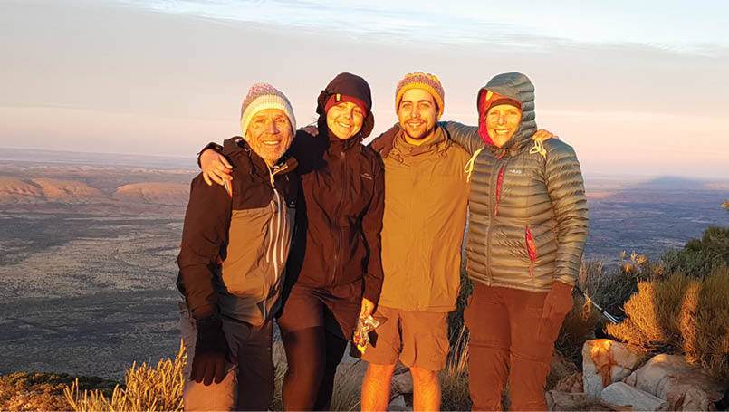

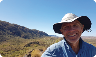
Gary, Shoshannah, Sheamus and Sue at sunrise on Mount Sonder
Soon enough, our trek began at the Alice Springs Telegraph Station. The four of us headed off into a warm afternoon along a flat grassy trail towards the sun. Around and before us were the ranges that would be our home for two weeks. Majestically coloured, enveloped in mystery and timelessness.
We ascended Euro Ridge, steeply tilted beds of rock levered upwards more than a billion years ago. As we rose the vista of the surrounding ranges was revealed and the desert winds blew in our faces. As if to accentuate the spirit of the adventure, in our vision a brown kite surfed the unseen waves of air cascading up and over the ridge. What a sight, what an introduction to Larapinta.
The preparationWalking Larapinta was not done on a whim. We had heard about it through friends and on the radio. So we researched it and thought, this will be tough but it sounds like it’s worth the time and effort.
The “we/our/us” in this story is my wife Sue, our youngest children Shoshannah and Sheamus and me (Gary). We all have some walking experience with packs and enjoy the rough adventure of hiking. Sue and I feel very lucky that Shoshannah and Sheamus, who are young adults, have taken a liking to bushwalking and do not mind walking with us.
Our time-frame for the walk was set at 15 days because of leave constraints for some (not for me!). So 14 nights meant 56 dehydrated meals, which took a while to prepare. The menu was somewhat varied:
Makhanawahla
British raj beef curry
Vege pasta
Spaghetti bolognese
Vege couscous
Chickpea vege rice
Barley risotto
Vege risotto
Stir fry
This is a total of 7.6 kilograms. Add to this about 25 kilograms for breakfast, lunch and snacks (which includes a few kilograms of chocolate and cheese). 32.6 kilograms of food for the four of us.
An important feature of the trail is the food drops where walkers can store food for the forthcoming sections, so reducing the initial weight carried. Food drops can also have a treat or two. We went for a bottle of red at each of the three drops along with some Jatz, cheese and shapes. That's living.
Alice Wanderers did our food drops and picked us up at the end. It all went to plan so a big thanks to Alice Wanderers.
“... this will be tough but it sounds like it’s worth the time and effort.
BWA October 2017 | 15
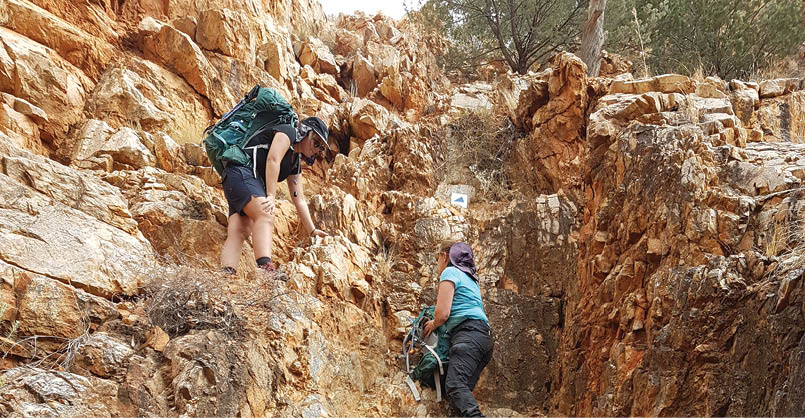

Scrambling to Standley Chasm at Cycad CreekSheamus O'Connor
Physically we prepared ourselves with local walks carrying weighted backpacks. So we were okay without being super-fit.
As we are dedicated athletes, our final preparations were intensive. Our flight to the Alice was via Adelaide with a three hour stopover; there are no direct flights from Brisbane to the Alice on week days. This gave us the opportunity to go to the City Markets and enjoy breakfast, followed by a stroll and a beer. Off to the Alice where once again we continued the fitness build up with some beers there too. We felt ready for the adventure.
Off we goWe started after lunch on Saturday 24 June 2017, when Shoshannah arrived on her flight from Brisbane. Our track was east to west (a lot of people go the other way) and, after a little trouble finding the actual track, we tramped off at 1.45pm. After a little over four hours walking, we arrived in camp at Wallaby Gap as the light faded. This was a busy camp with nine tents in total, including ours. We were a bit surprised at the numbers walking this lonely desert track.
Two other walkers arrived at about the same time as us and, as luck would have it, we shared the trail with them from Wallaby Gap. While we didn’t introduce ourselves at the first camp, being somewhat insular at this stage, we did later. Dean and Mick are their names.
I should explain our routine on entering camp. Tents would be pitched (they are amazingly easy to pitch these days), the Jetboil lighted to boil water for the food rehydration, which took about 30 minutes for firmer food pieces, such as carrot, potato and pasta, to soften. A nice cup of tea or coffee and some rich fruit cake, my Mum’s recipe. The fruit cake had been soaked in Grand Marnier for preservation purposes. Do we sound like alcoholics?
The rehydrated dinner would then be heated up to a simmer, adding water as necessary to provide a moist texture and delicious sauce. This would take about five minutes or so and then we would devour it promptly. There would be some miserly discussion about the distribution of cheese. Cheese proved to be a precious and treasured commodity on the walk, a cause of a number of family arguments.
“That’s a big slice!” “How come Dad gets three slices!” “We’re going to run out!”
Some chocolate, a clean of the teeth and bed, or should I say into the tent and slumber on light-weight mattresses.
I forgot to mention something very important, our showering – there was none apart from that oasis Ormiston Gorge, which will get
“Sue’s fear of heights surfaced high up on the ridges ...
16 | BWA October 2017
Day
Camped at
Km
Time
1
Telegraph Station to Wallaby Gap
14
3:45
2
Mulga Camp
30
7:15
3
Jay Creek
10
2:30
4
Standley Chasm
15
5:45
5
Birthday Waterhole Junction
18
6:00
6
Hugh Gorge
15
6:30
7
Rocky Gully
15
4:00
8
Ellery Creek
15
4:00
9
Serpentine Gorge
14
4:45
10
Serpentine Chalet Dam
15
4:45
11
Hermits Hideaway
15
5:30
12
Ormiston Gorge
12
3:30
13
Hilltop Lookout
19
4:45
14
Redbank Gorge
16
4:15
15
Mt Sonder
14
4:45
Itinerary


0
100km
75
50
25
a special mention later, and at Standley Chasm. Water is at a premium in the desert so a very basic wipe down with a damp cloth was the best to be done apart from swimming in a gorge. Then change into the cleaner set of clothes.
We took with us only two sets of clothes, a walking set and a night-time set. As you can imagine the walking set gained a life and personality of its own during two weeks of fairly hard walking, some more “outgoing” than others. (I am expecting to be interviewed by the NT Parks Department for allegedly killing a tree by hanging my jocks out to air on one of the branches.) As you can imagine, the “cleaner set”, while remaining technically that, would not be described as smelling like roses at the end.
Now I’m not going to bore you further with a step by step description of the walk but for those considering hiking the trail, I have put some detail of times and distances at the end.
So let me tell you a few tales.
The cathedral effectI have to jump in straight away and tell you this is the most stunning countryside. Your vision is taken up by spectacular views on all sides. The ranges of the West McDonnell Ranges, chiefly the Chewings and Heavitree
Ranges, are made up of jagged rocks formed from ancient sea beds. The colours and intensity vary throughout the day, changing the “feel” of the landscape quite dramatically, and mysteriously transforming the feelings of the viewer.
BWA October 2017 | 17

Within this harsh landscape a variety of plant life prospered. The spinifex appeared like soft light green cushions from the distance. Ghost gums stood out in the red landscape, white trunked with vivid green leaves. The crevices and narrow gullies in the rocks were vibrant green, very often with ancient cycads.
And just when you thought that you had seen all the spectacular sites possible, a walk into a gorge or a gap would envelop you in majesty. The nearest to the feelings I have had is that of walking into the great cathedrals of France, like Notre Dame and Amiens, so I have called it the "cathedral effect". I shall try and describe it by one example although there were many.
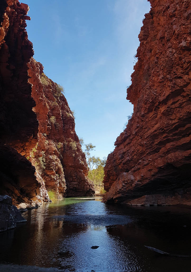
On day nine we arrived at Serpentine Gorge. After settling in we strolled up to the gorge in late afternoon. Turning a corner, the gorge stood in front of us. Red rock walls towered above the sandy base on which we stood and reflected in the water of the gorge. All
conversations stopped and the silence and grandeur of the scene enveloped us. Peace and tranquillity. As if to emphasise the scene and its ancient creation, the power and mystery of nature was evident in the rock walls, once great sea beds rendered vertical by some unimaginable tectonic force. And there, on the face of the rock, a “window” into that time, the preserved imprint of ripples on a sandy shore.
As with Notre Dame we walked up a ridge onto the “roof” of this cathedral gorge. On top there were not gargoyles or bells, but a view of the gorge as it went for several kilometres. Majestic.
We were able to swim at quite a number of these gorges and gaps. Now the water temperature was low, and some fish had died
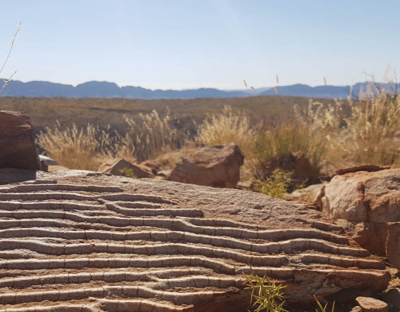
Ripples of the past, Heavitree Range, near Eagle Landing, an inland sea from about 900 million years ago Sheamus O'Connor
“All conversations stopped and the silence and grandeur of the scene enveloped us.
18 | BWA October 2017


because of protozoa (a natural process at this time of year) but we were pretty sweaty and only twice had the opportunity to shower along the way. So a swim was good. The water was bracing, I don’t know what the water temperature was but it was cold.
The fallsThis is not to be confused with waterfalls; there were none.
The trail has a reputation as being very rocky. It is in many parts and the potential for falling with ghastly outcomes is evident on the high ridges like Razorback or coming down from those ridges such as from Brinkley Bluff. Care is needed, and, in Sue’s case, a big shot of rum. Unfortunately we had not brought rum. Sue’s fear of heights surfaced high up on the ridges or on any rock climbs.
But these turned out to not be the most dangerous places. Shoshannah was the first to fall, coming down a set of rock stairs. A momentary lapse in concentration and over she goes, getting a big dark purple clam shaped bruise on the leg. She fell again later with less serious bruising.
Not to be outdone, Sue went one better. We were walking along a flat track across a plain littered with quite sharp rocks. I looked up and saw the World Expedition group (more about this wonderful group later) reaching the top of a saddle about a kilometre away. I said “Sue, look there’s World Expeditions.”
Sue looked up and went down hard. She had tripped on a rock hiding on the edge of the path, falling onto a set of hard pointy rocks on the edge of the path. Immediately her upper arm swelled up and her wrist bled. Sue was in pain and I thought there may be a breakage.
Fortunately not, although a very nasty bruise appeared on her arm. This bruise caused me all sorts of grief. Not only had I caused the accident by telling her to look up (Sue
takes no responsibility for not looking where she was going) but people we met would say, “That’s a nasty bruise! How did you get that?” followed up with a judgemental look at me.
Sue would fall again, once more a trip on a rock hiding on the edge of the path this time knocking her head. Fortunately I was blameless and the head knock was not too bad.
Vision splendidThe trail was designed to show off the landscape of this remote area. As a consequence the trail winds up and over hills and ranges so that the hiker, although tired from the climbing, is rewarded with tremendous views, looking forward and backwards, left and right along the path. The views are stunning.
Sheamus and Shoshannah at Counts Point looking west to Mount Sonder,Gary O'Connor

Euro RidgeSheamus O'Connor
BWA October 2017 | 19
After Euro Ridge, the first couple of days were relatively flat and quite unseasonally warm, in the high twenties. We could not imagine what it would be like to be out on the trail in summer.
Our first experience of the high views was at Pravda Spur and Lorettas Lookout, at least Sheamus and me. Sue was dwelling on her paranoia of heights at this early stage and so took the alternative low route with Shoshannah. Sheamus and I drank in the views of the Chewings Range. The range was formed over a billion years ago when some ancient seabed was squeezed and pushed up.
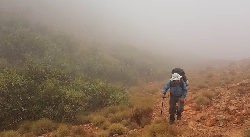
Most walkers would next comment on Brinkley Bluff, a much vaunted sunrise and sunset spot. Not so for us. Low cloud had settled on the 1200 metre high ridge and made visibility close to about 30 metres. This was good news for Sue who was unable to see the deep chasms around us or imagine tumbling clumsily down them.
The mist gave us the opportunity to notice the clever survival techniques of the little trees on the ridge. They capture the moisture of the mist in their leaves which then falls in drops on the soil surrounding their roots.
Sue’s relaxing blinkered walks along the ridge lines did not last. The next day the weather cleared and the trail once again headed
up onto the Chewings Range (we had descended some 380 metres the day before) and Razorback Ridge. The name says it all. To Sue it was an impossibly narrow path of jagged rocks waiting to trip her and send her plummeting to certain disfiguring death, on either side. She managed somehow and even was able to look up from the perilous depths to admire the stunning view of Hughs Gorge in the distance.
On we went. The day we ascended to Counts Point on the Heavitree Range was picture perfect, views for kilometres in every direction. Similarly, the steep climb up from Waterfall Gorge had the reward of a spectacular view of Mount Giles and Mount Sonder.
Gary on a misty hike up to Brinkley BluffSheamus O'Connor

Mount Sonder at sunset from Hilltop LookoutGary O'Connor
20 | BWA October 2017
Another highlight was relaxing by the waterhole at Davenport Creek. We arrived at about 1pm on a warm day and immediately stopped when we saw it.
Our last ascent was Mount Sonder with an elevation gain of over 700 metres in the dark. We rose early to climb Sonder for sunrise. With head torches shinning brightly we set off at 4am for a two and half hour walk. It was near a full moon, which shines brightly in the desert, casting the shadows of the mountains onto the landscape. This morning we were also lucky enough to see the moon set, golden like the sun into the desert beyond.
Our head torches cast the shadows of the jagged rocks, illuminating images in the mind of sheer cliff faces beneath the shadows. A wrong turn and it's a funeral. The light of day on the descent showed a much less threatening path. Sue nervously continued in the dark.
We reached the top after moon-set, as the sky just started to turn from star-punctured black to a hint of star bejewelled blue. The night sky had been a brilliant part of our hike, with the Dark Emu clearly visible in the Milky Way on many nights.
At the top were some people from World Expeditions that we had become quite friendly with along the way (and who I blame for making Sue trip). Eight walkers,
carrying day packs, left Alice Springs with their guides Alice and Ed. Six of the walkers finished the full walk, including a 31 kilometre day that started and finished in the dark. World Expeditions provide a fully supported end-to-end walk which includes World Expeditions’ own separate camp sites and delicious guide-cooked food every night. They walked the whole way and loved it. Alice and Ed were lovely and, as it turns out, were brother and sister. We had many a chat with the World Expeditions crew, sharing our experiences and the joy of the trail. They also shared some of their food with us when they had excess. That was much appreciated.
_photo_by_Gary.jpg)
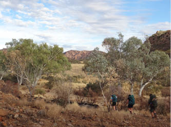
The family at twilight, Jay Creek
Sue, Shoshannah and Sheamus leaving Spring GapGary O'Connor
“The night sky had been a brilliant part of our hike ...
BWA October 2017 | 21
“... one of the really pleasant surprises of the hike was the friends we made.
“A few people along the way had said to Sue and I that we were lucky that our adult children wanted to walk with us. We are. That says it all.

I’ll just divert a bit and advise that one of the really pleasant surprises of the hike was the friends we made. I imagined a rather lonely walk in this remote part of Australia with only a few other walkers along the trail. In fact it was reasonably busy, with a few camps having over 10 people camping. Serpentine Gorge had about 20 people including a French group, some avid walkers from Victoria that had escaped the cold wet winter and a couple of adventurous young women who wore hats with “surf rescue” written on them. They made a pastime of swimming up gorges to find the more inaccessible ones. They carried a ukulele and sang us to sleep.
We were lucky to make special friends of a number of people that we shared the track with. Jonas and Jasmine, the Cairns couple, Stuart and Alex, the Perth couple, Dean, the medical student from Melbourne and Mick the creative artist from Melbourne. It was nice to sit down at the end of the day and talk about the day past and things in general. It was something special.
As we all know, when humans get together and start talking, they can’t help but gossip. And so various trail gossip tales gained lives
of their own. For example the nude hiker who was travelling with a journalist and the lady hiking with a porter (or slave). One of my favourites (apart from the nude hiker) was the reported mouse and cow plague at Jay Creek. A mother and daughter party told us that Jay Creek, our next stop, was overrun with mice and cows. We decided to sleep on the shelter platform at Jay Creek, probably to limit the risk of being trampled by the impending cattle stampede. Sue insisted on me pitching the tent on the platform to stop the mice from nibbling her appendages. As a further level of security Sue positioned my sleeping mat beside the tent so that the pestilence would start on me first. It worked by some means or other, we only saw one mouse and no cows; perhaps my vile body odour caused them to up and leave.
Another favourite was Ormiston Gorge. Like the incessant beat of native drums the story of the gorge and its fabulous food drove us on. From camp to camp, as we rehydrated our food, we heard rumours of steak sandwiches, vegetable lasagne, unbelievable
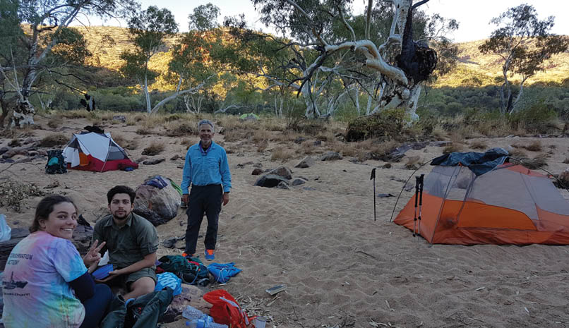
Shoshannah, Sheamus and Gary at the last camp, Redbank Gorge Sue O'Connor
22 | BWA October 2017
Gary lives in Brisbane, Queensland. Gary and Sue have three children, all grown-up, with only one still at home. Their oldest lives in the United Kingdom, so he missed out on the Larapinta trail. The family shares a passion for the outdoors and exercise including bushwalking, running and skiing. The last full family holiday was a wonderful skiing trip to Nozawa Onsen in Japan. Gary is retired and finds there still is not enough time to do all the things they would love to do.

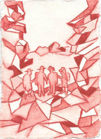
The Family Painting by Mick Douglas, 2017, Larapinta
biscuits and slices. And showers! And chairs and tables! We reached this nirvana in the desert and were very satisfied as we gorged ourselves on all these delights, sat in comfy chairs and smiled. Serenity now.
Back to Mount Sonder. A beautiful sunrise greeted us all on a chilly morning. The shadow of Mount Sonder behind us in the west like some ancient pyramid. All on the mountain top felt the warmth of the new day and the joy of the Larapinta Trail.
The FamilyI hadn’t thought of us unusual when we set out but apparently we were. We became known as the Family walking the trail. Apparently people would mention us, “has the Family been through?” On Mount Sonder a few of the World Expeditions team took pictures of us!
A few people along the way had said to Sue and I that we were lucky that our adult children wanted to walk with us. We are. That says it all.
ResourcesOur Larapinta blog has details of the trip.
We used the book Larapinta Trail by John and Monica Chapman to guide us on the trail. The maps were handy. It is worth noting that the trail is well marked and easy to follow, thanks to Northern Territory Parks and Wildlife and the volunteers who help with track maintenance. More information regarding the book is available on John Chapman’s website.
The Northern Territory Parks and Wildlife website has good information on the trail. A number of walkers found the PWS maps to be very useful. They may be purchased with the information pack through the website.
The Larapinta Trail website is very useful. For us the general information was great and the information on food drops and transfers helped greatly with the planning.
As noted above, Alice Wanderers did a great job with our food drops and transfers.
And finally for those who would like to enjoy the wonders of the trail without lugging a heavy backpack, we found Alice and Ed of World Expeditions to be top people.


BWA October 2017 | 23