


My partner and I are took an extended overseas trip, and tried to fit in as much walking as possible, from Patagonia to Nepal and various places in between!
Descent to Laguna Los GuanacosAll pictures by Alexander Willows

Los Dientes Circuit, Southern Chile
Alexander Willows

22 | BWA February 2019


Traversing the mountainside, views of Los Dientes
The Los Dientes de Navarino (The Teeth of Navarino) are located on Isla Navarino, located in the extreme south of Chile on the southern side of the Beagle Channel. The circuit is about 50 kilometres sans sidetrips and is described in various places on the net and in books. Some people name it the most southerly major walk in the world, located as it is at around 56 degrees south. For anyone who has done much walking in Tasmania, it is a comfortable combination of fagus, cushion plant and occasional mud, mixed with some very non-Tasmanian elements. There is a fantastic guide booklet produced by the Chilean government with more than enough information (including regular compass bearings!) to make the walk safely. Somewhat ironically, it is widely available in Punta Arenas, but almost impossible to find in Puerto Williams. We borrowed a copy from a local tour operator, which we had to return once back in town. The local tourist information office presumably would have them available, if the lady running it had not run off with a foreign sailor some time ago, yet to be replaced it seems! Certainly wasn't open while we were there anyway.
As do many, we took a boat from nearby Ushuaia, in Argentina, to Isla Navarino. We used Onashaga Expeditions, and the trip cost us US$120 each, if I recall correctly. It involves a 30 minute or so boat crossing and a significantly longer bus ride to the main settlement of Puerto Williams, population about 1800. There were plenty of operators offering the trip from the waterfront of Ushuaia, with slightly varying prices. One can also take a ferry from Punta Arenas (32 hours on the boat, very scenic, much more expensive) or fly from Punta Arenas (cheaper than the ferry, availability varies depending on the day of the week).
We left for the walk the day after arriving in Puerto Williams after stocking up (I recommend Simon y Simon supermarket) and registering with the local police. It's a road walk out of town at first until arriving at a set of waterfalls, where the real track begins. An extended ascent follows to Cerro Bandero (Flag Mountain), a hill visible from
“Some people name it the most southerly major walk in the world ...
BWA February 2019 | 23


Heading along the ridge on our short detour, Paso Australia in the sun
Puerto Williams with - surprise, surprise - a large Chilean flag. Not sure I've ever seen a country so seemingly patriotic ... Chilean flags are everywhere here!
After reaching the flag, one makes a slow ascent across very open, flat ground, before reaching an undulating traverse along the mountainside with beautiful views. There is a steep drop at times, and some slightly loose bits, but certainly nothing of real concern. Many photos later, we arrived at our first campsite at Laguna del Salto, a beautiful spot with space for 5-6 tents in various locales around the lake shore. We were joined by three other tents - one of which contained a fellow from California whom we had adopted on the boat ride from Ushuaia and became fast friends with.
A still night by the Laguna saw us with a tent dripping with condensation the following morning - such is life! After allowing it to dry for a little while, we packed up and headed around the edge of the lake, up past the waterfall and into a lovely little valley which led us up onto some barren scree slopes under impressively sharp looking peaks. We made a quick detour along one of the ridges
here for views back over the campsite and the Beagle Channel (well worth it) before continuing on to Paso Australia. Not really much of a pass to speak of, it's just a bit of a saddle reached before descending to traverse above Laguna Paso. After making it around the corner past the laguna, we arrived at a track junction, with the option to continue along the circuit or to head to Lago Windhond, a little further south. We chose the sidetrip, which looked great in all the other reports, and came highly recommended for views, particularly from the summit of Monte Bettinelli. Which of course was where we had our worst weather of the trip, an hour or so of gusty wind and driving, cold rain. Such is life, I suppose. A pleasant descent over open scree past Laguna Bettinelli, followed by a steep-at-times descent through some lovely forest, a quick river crossing on some fallen logs and a seemingly interminable stroll across a cushion plant meadow had us arriving at Cabana Charles, near the shores of Lago Windhond. A long day, but beautiful.
“We chose the sidetrip, which looked great in all the other reports ...
24 | BWA February 2019


Heading back to the circuit from Lago Windhond
The following day we made a daytrip down to Bahia Windhond (Windhond Bay), with great views down to Cabo de Hornos (Cape Horn). Pretty simple sidetrip - find the eastern shore of the lake and follow it until reaching a cairned pad heading south-east, which fades in and out but leads you generally towards a river crossing, and eventually the bay. Took us about 3.5 hours each way, if I recall correctly. There is a pad in the forest at the start when coming from Cabana Charles, but we found it better to just walk on the beach - much more open, way fewer downed trees.
The next day had us headed back up over Monte Bettinelli (with clouds obscuring much of the view, of course) to rejoin the circuit, followed by some pleasant walking around some lovely lakes before eventually arriving at camp at Laguna Escondida (Hidden Lake). We passed a number of areas this day where the destruction caused by beavers was very evident, with lots of deads trees and flooded basins. Beavers were introduced some time ago in an effort
to create a fur trade, but whilst that effort was not successful, the beavers certainly were. Their influence is obvious throughout much of the walk. Don't worry though, you can get your own back on them - have a go at a beaver pizza at the local pizzeria in Puerto Williams. Sadly, it was sold out when we were there, and the beaver hunter was apparently away, or sick, or for whatever reason not busy catching beavers!
We had a pretty windy night and interrupted sleep at Laguna Escondida, but it was still a beautiful campsite. It was made even better when we were given an extra lunch by a
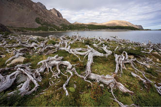
Dead trees by Laguna Los Dientes
“... the destruction caused by beavers was very evident ...
BWA February 2019 | 25

Cerro Clem and friends
not-as-hungry-as-he-thought German fellow. Score! Apparently Aconcagua had given me a serious case of the hiker munchies, and I was making a habit of waking up in the middle of the night to scoff half of the following days' worth of nuts. This, added to the constant complaints about being hungry, did not seem to be endearing me to my walking companions. Needless to say, we took more food on the next walk.
From Laguna Escondida, we headed to just past Laguna Los Guanacos (Lake of the Male Guanacos, not to be confused with Laguna Las Guanacos, Lake of the Female Guanacos). Leaving the lake, we made our undulating way through various bits of forest and an open grassy valley before eventually ascending to Paso Ventarron (Gale Pass), which thankfully didn't quite live up its name. A descending traverse with stunning views to the west was followed by an equally stunning walk amongst various lakes and tarns, eventually leading to lunch somewhere near the shore of Laguna Martillo, under the watch of the fantastic Cerro Clem. This mountain was named for Clem Lindenmayer, the Australian fellow who apparently first walked or proposed this circuit, back in the late
1990s or early 2000s as I understand it. Onya Clem! After lunching here, we made our way through the beautiful valley to the beginning of the ascent to Paso Virginia, our last pass and the highest point on the normal circuit (Monte Bettinelli is slightly higher). It was a little muddy, and the track a little hard to find at times, but after a steady plod we made it to the top, to be met by fantastic views back across the valley, and eventually to fantastic views across the Lagunas Guanacos and the Beagle Channel. Fantastic views were certainly a recurring theme of this walk! And I'm sure the weather is always like this, too.

View back towards the valley while nearing the top of Paso Virginia. Cerro Clem and his cirque of friends.
26 | BWA February 2019


Descent to Laguna del Salto - steep and rocky, with some loose slippery gravel in a few spots
After spending the night at some nice sheltered sites in the forest beyond Los Guanacos, we trundled on down to the road the next morning and managed to score a lift back into town. Sans hitch, it's a 2 hour or so walk back along the road to Puerto Williams, passing an abandoned cannery fairly early on.
All in all, five nights and six days of great, varied walking, lovely scenery, good company and fantastic weather. Definitely one to put on the list for anybody thinking of heading to this area. I thought it was a better walk than Torres del Paine, and certainly far less crowded. The local police (Carabineros) said they get around 1000 people/year, plus or minus. For better or worse, this number
will likely increase, as apparently the Chilean government is pushing this walk as an alternative to Torres del Paine in an effort to reduce the overcrowding issues there. Given the remoteness and access issues, I don't see it ever really taking off to that scale, but I certainly see it becoming more busy. One can only help that sufficient track work and infrastructure come with the increase in numbers.
Anyhow, congratulations if you made it to the end, and thanks for reading. After Isla Navarino, we took the 32 hour ferry to Punta Arenas (well worth the trip, though apparently better in the other direction) and then headed on to Torres del Paine.


BWA February 2019 | 27