
Day 1 - Simpsons Gap
Larapinta Trail
Text and photosSonya Muhlsimmer
I would like to start by paying respect to the traditional owners and custodians of the Central and Western Arrernte Country.

18 | Bushwalk October 2023
L rapinta is named after the traditional custodian’s name for the Finke River. This river is thought to be the world’s oldest river, following the same course for over 350 million years, in the land of the Arrernte People. The Arrernte have generously allowed walkers to pass through some sacred sites, and the walk also follows some Dreamtime song lines. Arrernte mythology focuses on the landscape. Altijira is the creator being of the Inapertwa, the ancestral creatures that formed into humans and all living creatures.
In July 2023 my friend Elsje and I spent 16 days walking in the MacDonnell Ranges, Northern Territory, completing the Larapinta Trail, 231 kilometres, plus 27 kilometres
of side trips. The walk starts at Telegraph Station, just a few kilometres outside Alice Springs and ends at Redbank Gorge where you climb the fourth highest mountain in the NT, Mount Sonder, 1380 metres high. The trail passes through some amazing countryside, crossing over open desert plains, rocky creek beds, high rocky ridges and through some pretty spectacular gorges.
There are twelve sections of the Larapinta Trail and at each trail head there is a shelter, some of which have a solar charger but not to be relied upon, water tanks, pit toilets and campsites maintained by the NT Parks. There are costs involved in walking the trail end to end such as walking, camping and park fees in which all revenue raised will help manage the park's camp sites.
"
The outback is a magical place that will get under your skin.


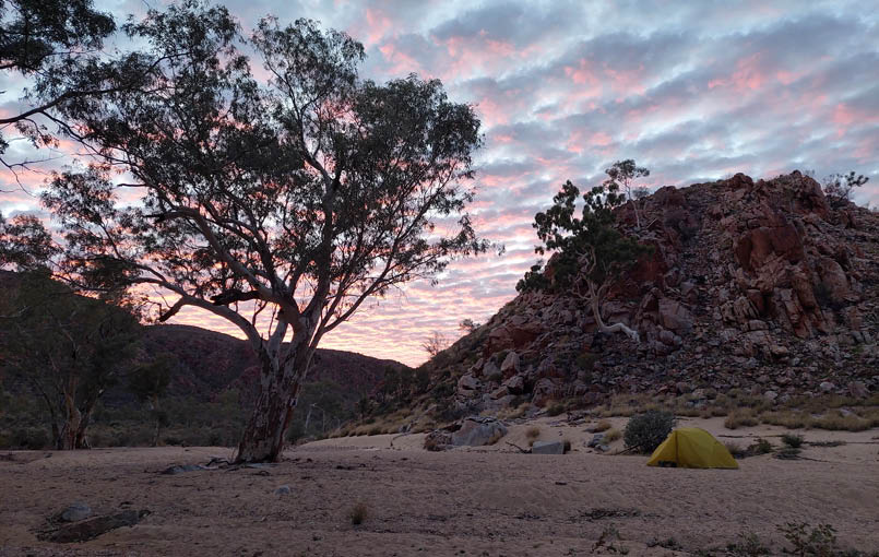
Day 2 - Arenge View with Elsje. Lunch spot

"
This river is thought to be the world’s oldest river, following the same course for over 350 million years, in the land of the Arrernte People.

19
Also there are the food drops, pick up or drop off that you have to organise. You can complete the walk self-supported which we did, or you can go with a guided tour. Also, you don’t have to do the whole walk, doing as much or as little as you like, but I recommend doing the whole walk to experience the true variety of what the desert, and the walk has to offer. There are many other areas to camp along the way, and you don’t need to make the trail head each day. It is not a technical walk, there is a well-marked trail but it is rocky in many areas and there are some large hills to walk up too, it is just the kilometres, oh and
the rocks that make it difficult. It is well worth it and I suggest to take your time and factor in some rest days. The outback is a magical place that will get under your skin. This is the third time I have been in the outback and I dare say, it won’t be my last.
Day
Section
Details
Distance km
Time
Elevation (max and min)
Grade
1
1
Alice Springs to Simpsons Gap
23.8
9 h
777577
Medium
2
2
Simpson Gap to Jay Creek
25.1
9 h 40 m
812606
Medium
3
3
Jay Creek to Standley Chasm
13.6
8 h 10 m
958716
Very hard
4
Rest day
5
4
Standley Creek to Birthday Junction
17.9
9 h 20 m
1195693
Very hard
6
5
Birthday Junction to Hugh Gorge
16
9 h 35 m
789733
Very hard
7
6
Hugh Gorge to Ellery Creek North
31.2
9 h 50 m
871666
Medium
8
7
Ellery Creek North to Serpentine Campsite
13.8
4 h 5 m
762658
Medium
9
Rest day
10
8
Serpentine Campsite to Serpentine Chalet Dam
13.4
6 h 56 m
1142726
Hard
11
9
Serpentine Chalet Dam to Ormiston Gorge
28.6
11 h 50 m
1073650
Hard
12
Rest day, Ormiston Pound
9.4
3 h 25 m
13
10
Ormiston Gorge to Finke River. We did 19.1 km and camped at Hilltop Lookout
9.1
7 h 20 m
996629
Medium
14
11
Finke River to Redbank Gorge. Starting at Hilltop Lookout we did 15.8 km.
26
5 h 10 m
992662
Medium
15
12
Mount Sonder day trip
15.8
7 h
1344670
Hard
16
Pick up, to Alice Springs
"
It is not a technical walk, there is a well-marked trail ...
20 | Bushwalk October 2023
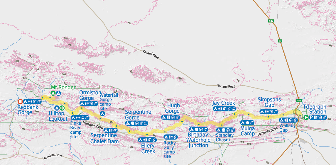

Bushwalk.com notes and maps on webpage, GPX and PDF
This map is © Bushwalk.com and is created using data © OpenStreetMap contributors
Larapinta Trail


0 km 10 20 30 km

Road, four-wheel drive track, walking track (treed)
Main track, side trip, alternative route
Cliff, major contour line, minor contour line (100 metre interval)
Lake, river, waterfall or creek


Shelter
Campsite
Hut
Toilet
Drinking water


Parking
Start of the walk
Mountain top
View
End of the walk


21
Day 1: Alice Springs Telegraph Station to Simpsons Gap After leaving the creature comforts of the motel, the taxi dropped us off at Telegraph Station around 7.30 am where the walk officially begins. Telegraph Station is one of the original sites of European settlement and was established in 1872. It is an interesting tourist destination if you have time. However, onwards we go and in no time we reach Euro Ridge. This ridge provides sweeping views back to Alice Springs and the highest points of this ridge represents the head and back of the Euro ancestor. This spirit created the water holes around Alice Springs while digging for water. Wallaby Gap was reached around lunch time and provides a perfect spot to stop with a shelter, appropriately named as I saw a wallaby. Coming down the hill to the camp spot a little willy wagtail bird was following me; he even came and sat on my pack for a free ride for a bit and tried to share my lunch with me at the shelter. After lunch it was onto Simpsons Gap, or Rrengetyirpe as
it is known. This is a sacred site and I can’t quite name the feeling I had when I sat next to the waterhole, but it had the most peaceful feeling to it, a stunning and magical place. Back at the walker’s campsite, two solo walkers Gina and Darryl were there. It was funny as during the trip we ran into these two quite a lot. Apparently late at night there was a lot of noise coming from the carpark, which was a few hundred metres from the walker’s campsite, however I did not hear a thing.
Day 2: Simpsons Gap to Jay CreekSection two is mostly flat with a few points of interest such as Bond Gap, Arenge View and then Spring Gap. Also this section is the home of some brushtail possum colonies which is

"
This is a sacred site and I can’t quite name the feeling ...

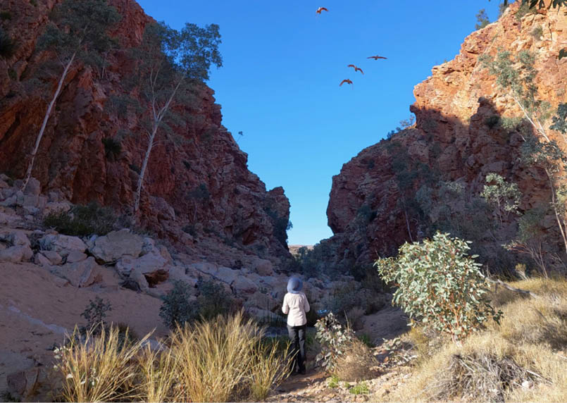
Day 3 - Looking back at the Chewings Ranges
22 | Bushwalk October 2023
quite rare in this part of Central Australia. The waterholes had water after all the rain from a week prior and made a stunning sight. Bond Gap is a permanent waterhole but Spring Gap is not so it was good to see it with water in it. Lunch was called around Arenge View, which is not far before Mulga campground, oh what a view we had. Onwards we walked until Jay Creek.
Day 3: Jay Creek to Standley Chasm Today was a lot harder that the first two days. It is the steepest, roughest and most rugged section of the trail through the Chewings Ranges. The guide book tells me Jay Creek to Millers Flat climbs up to 210 metres with a descent of 140 metres. Starting at Jay Creek, a sandy creek that leads to a permanent waterhole known as Fish Hole. In the Dreamtime a serpent found this passage, it is a sacred site. Past Fish Hole the track follows a rocky creek up the gorge, then climbs a spur, then descends then climbs
up into a saddle then descends into the next rocky creek. Then the track rises to a saddle then down into the next rocky creek until the track finally reaches Millers Flat. There was scrambling involved in some areas and it was unrelentingly rocky. From Millers Flat to Standley Chasm, this part of track rises with an ascent of 180 metres and a descent of 230 metres, here we go again.
After lunch at Millers Flat the track again meanders up and down over a saddle and down the rocky creek through to Fig Spring with more scrambling involved. Just when you thought you have had enough scrambling the
"
It is the steepest, roughest and most rugged section of the trail through the Chewings Ranges.


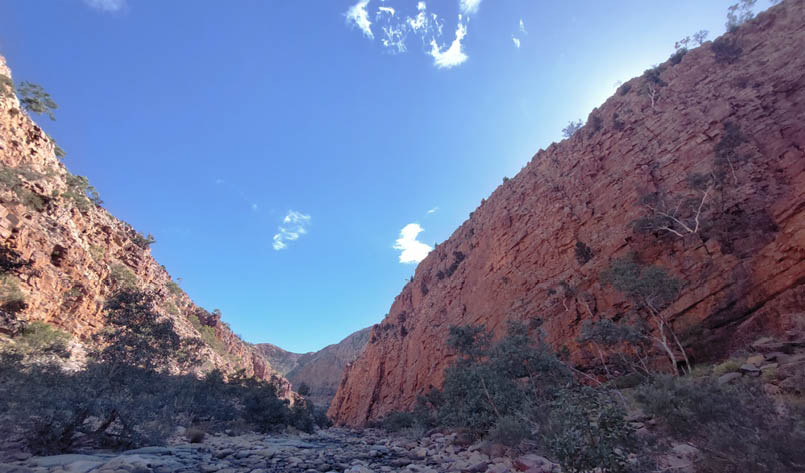
Day 4 - Standley Chasm
23
track seemed to disappear, I thought I had lost the track at some point but no it was more scrambling a few metres up the left side of a water hole, along another rocky creek bed and then a steep climb up a dry waterfall around 10 or so metres high, it was challenging. Once out of the gorge the track opens up and climbs to a saddle. You guessed it, then back down into the gully and back up a spur. This is now a lookout point near Standley Chasm. The GPS tells me we are not far from Standley Chasm, about 1.5 kilometers, but that is the way the crow flies. The track goes steeply down, then steeply up then steeply down again. By this time, we were totally exhausted, and completely over it but we finally reach Standley Chasm and set up camp. The next day is a rest day, thankfully. There are showers, a washing machine, a café and our first food drop at this camp site so a little bit of luxury with a real coffee, oh and a cider and yummy snacks too. Guess who we saw here, Gina and Darryl.
Day 4: Rest dayA rest was definitely needed today so it was taking it easy in the morning, indulging in a shower, real coffee at the café, doing some clothes washing, cooking pancakes, eating snacks and walking to Standley Chasm, which is all flat ground and only a short walk away. Gina had a rest day with us but Daryl continued on to the next campsite along the way. Standley Chasm, or Angkerle Atwatye, the Gap of Water as it is known, is an important cultural site for women and the area is privately owned by the local community members.
The chasm itself is 80 metres tall and around three metres wide at the narrowest point. There was a pool full of water through the chasm so unless you swim, you couldn’t get past. The walls in the chasm change colour depending on where the sun is and around
noon the walls light up to the most amazing red colour. It is spectacular to see, but a very busy place at that time. It was nice to visit the chasm again in the afternoon after all the tourists left.
Day 5: Standley Chasm to Birthday Junction Section four is graded very hard due the ascent and descent. Brinkley Bluff is one of the highest summits on the trail at 1209 metres with many false summits, and coming down near Reveal Saddle it is very rocky and steep. The walk starts just out from the entrance to Standley Chasm walking down a rocky creek bed, then the track continues to rise to the numerous saddles and follows narrow spurs then passing a few knolls up to the summit.
The views are amazing up here and Brinkley Bluff is a great spot for lunch, again the track is a very steep, zig zag descent. After a while, the track starts getting easy all the way to Birthday Junction, it was a real pleasant flat part of the trail. To see the waterholes you have to walk about 900 metres away from the shelter, passing smaller waterholes along the way. The first waterhole makes a fabulous camp spot for the night, you guessed it, Gina and Darryl were here too.
Day 6: Birthday Junction to Hugh GorgeSection five gets talked a lot and Hugh Gorge is a real highlight of the trip, and I must say it was spectacular. There is also a swim through cold water. The length of the swim and the depth depends on how much rain the desert has had. I packed a dry sack for the pack just for this section. Not too long after leaving the junction the rock scrambling through Spencer Gorge begins. It is not a long gorge, just over a kilometre but the amount of boulders you have to navigate will slow you down. However, the different plant species growing and the
"
... an important cultural site for women and the area is privately owned by the local community members.

"
To see the waterholes you have to walk about 900 metres away from the shelter, passing smaller waterholes along the way.
24 | Bushwalk October 2023
rock formations it is worth a slower walk to take it all in. Once out of the gorge it is a climb to Razorback Ridge, this is an impressive, thin ridge line with amazing views which does involve a little scrambling. The track descends into the gully, cross Fringe Lilly creek and soon the track gets to the Hugh Gorge junction. We finally reach the water so we scramble on the right side for as far as we can, take off our packs and investigate. Gina was walking with us and there were also two other people we have met previously, John and Peter, a father and son duo. On the bank, after the swim there were two other people, Amy and Hien who we have met before and they instructed us on what to do. Amy waded through the water to the boulder, Gina lowered her pack off the boulder, Amy grabbed the pack and walked to the bank. Gina then jumped into the water to swim around the boulder, it is only about a two metre swim and then once around the boulder, the water
is waist deep. I am waiting on the boulder for Gina to take my pack, I jump in and swim then go to the other side of the boulder to get Elsje’s pack and so on. It was easy with the few of us. From here it was not long to the camp site.
Day 7: Hugh Gorge to Ellery Creek NorthOnce out of the gorge, the landscape opens up with less scrub and wide open plains, looking back to the Hugh Gorge, at Hugh View was impressive. However, in one part, a recent fire has cleared a lot of the shrub and all that was left was red dirt, rocks and burnt shrubs, it was quite surreal as in a sense this is what you expect the desert to really look like. It was hard as there was no shade and full sun so the walking was tiring. Passing through Rocky Gully was just that, a rocky gully, but it did have a little bit of water in the creek. Ellery Creek North was reached and our legs were sore and we were tired. It was good to get to camp.
Day 6 - Camp at Birthday Junction Waterholes
25
Day 8: Ellery Creek North to Serpentine Gorge After packing up camp, it was down to Ellery Creek to check out the gorge and oh my it was gorgeous. Oh and the birds that were around in this campground, in the creek and in the gorge, there were so many. We saw Galahs, Black cockatoos, a Falcon and Budgerigars too, such a special place full of life. On the way we stop to look back at Ellery Creek at the lookout, which is on the top of a
hill. The scenery is really something out here, I am in awe. A little while later Spring Gap was reached and a small scramble is required then it was not long to our next campsite. Another food drop is waiting for us here with some yummy snacks and a small bottle of cider.
Day 9: Rest day It was good to sleep in a bit and not have to pack up camp. Today is just about relaxing, walking to the gorge, up to the lookout to see down into the gorge and that’s it. Serpentine Gorge, Ulpma as it is known, is a permanent waterhole and is a refuge for rare plants and lots of animals. The Dreamtime story is of the Carpet Snake, the story can only be told to an initiated Aboriginal man. Swimming is forbidden. Gina and her dad Monty turned up tonight. Monty started the walk at Ellery Creek South and will be completing the walk.
"
The Dreamtime story is of the Carpet Snake, the story can only be told to an initiated Aboriginal man.
Day 8 - Ellery Creek North
26 | Bushwalk October 2023
Day 10: Serpentine Gorge to Serpentine Chalet DamDoing the walk east to west is a great way to build up to climbing Mount Sonder as from certain vantage points, such as Counts Point you can see it in the distance and at each vantage point from here in the Mountain gets bigger and bigger and the excitement grows to climb it. Counts Point is well worth the side trip and a great spot for lunch, it has majestic views. On the top of the ridge there are numerous stones that show erosion marks of ancient sea beds, it was quite interesting to see. Down past Lomandra gully there was another section that was burnt out. However, according to the guide book, this is common for this area and why the trees are fairly small in this area. Once at the camp site and after a bit of a rest it was down to see the remnants of the Serpentine Chalet Dam. The dam was built in 1960 to open the area up to tourism, however the chalet was only operational for a few years due to lack of business and lack of water. All that remains here is the cement wall of the dam. I took my shoes off and walked into the water for a swim, I only got as far as my knees as the water was too cold.
Day 11: Serpentine Chalet Dam to Ormiston GorgeToday was very long, perhaps too long. However, the highlight for me was walking through the Inarlanga Pass. This rough pass marks the boundary between two different tribes. Custodians of the Ochre Pits do not go through the pass unless given permission or invited to attend ceremonies at Giles Springs.
The landscape was different on either side of the pass and walking through it had such a special, spiritual if I can say feeling and I could not help but wonder about the men that used to walk here, how they would have felt passing through this area. What a powerful feeling this area had on me. Then there is the scenery, it took my breath away seeing ancient cycads and river red gums dwarfed by the vertical bands of red rock.

"
Custodians of the Ochre Pits do not go through the pass unless given permission or invited ...

Day 10 - Counts Point with Mount Sonder on the left skyline
27
Day 12: Rest day. Ormiston Pound return Ormiston campsite has a shower, café and a food drop, and today is a rest day. After a long hot shower, a real coffee and brunch at the cafe, it was off to explore the Pound walk. At least there was no pack to carry. Ormiston Gorge is a sacred site and a permanent waterhole and the walk through the gorge takes about three hours and involves a deep wade. The track starts climbing around the range for some absolute amazing views then the track follows down into the pound with some towering red rock walls, it is a loop walk. After you start walking through the gorge you come to the waterhole, which was around 15 metres wide but can vary in width or depth at any time of the year. The water was so cold, I had to climb out on some rocks half way to get some feeling back in my feet. From here it was only about 30 minutes back to camp, for a long hot shower and a cider. In the afternoon it was down to the waterhole, not for a swim but to take in the stunning sights of this gorge.
Day 13: Ormiston Gorge to Finke RiverThis is the shortest section, but you could add on a side trip to Glen Helen from here if you wanted to camp at Finke Creek. However, our plan was to walk a few more kilometres, camp at Hilltop Lookout as this will reduce the kilometres the next day. The Finke River is one of the four main rivers of the Lake Eyre Basin, the river contains some of the largest permanent waterholes in Central Australia. It’s Arrernte name comes from Lhere Pirnte, taken as Larapinta, which means salty river. It is thought to be the world’s oldest river following the same course for around 340 million years and the Finke was formed when the rainbow serpent thrust north from Lake Eyre. It was absolutely beautiful and such a special place.
"
The huge bright red walls are something of a must to see ...
Day 12 - Ormiston Pound walk
"
It’s Arrernte name comes from Lhere Pirnte, taken as Larapinta, which means salty river.

28 | Bushwalk October 2023
Section 11: Finke River to Hilltop Lookout Along this section the views over to Mount Sonder gets better and better and camping at Hilltop Lookout was the highlight campsite of the trip for me. The sunset and the sunrise made carrying that extra water up a hill well worth to reach a height of 1010 metres. Watching the colours change over Mount Sonder at sunrise was spectacular, the Mountain changed into so many different shades of red with the changing sun, it was a real highlight.
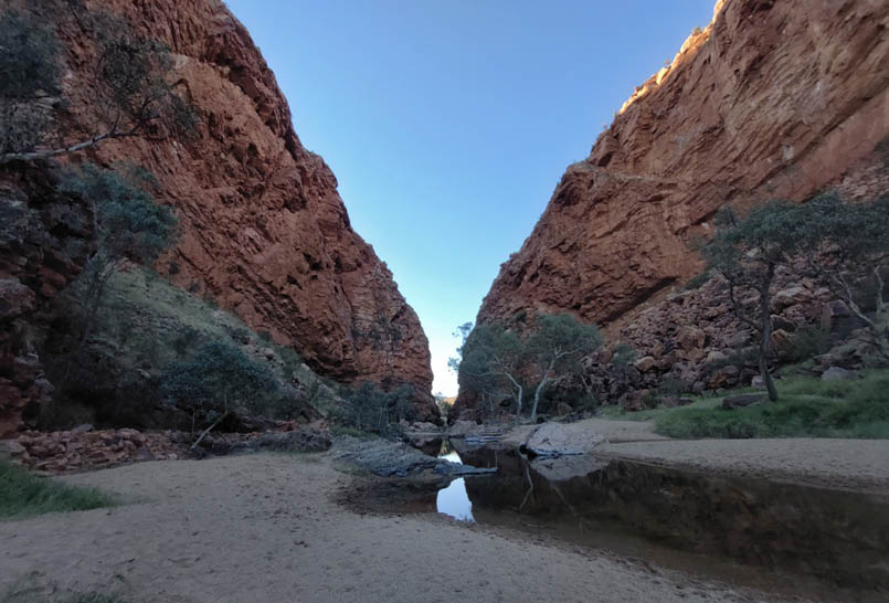
Day 14: Hilltop to Redbank Gorge After packing up camp, it was down the hill and through Rocky Bar Gap. Soon after the track follows the base of Mount Sonder and into the Redbank Gorge campsite. After a bit of a rest it was time to explore Redbank Gorge, known as Yarretyeke, a sacred site. Again there is a lot of scrambling involved to get to the gorge and the main swimming hole. The huge bright red walls are something of
a must to see and the water is very cold too, but hard to resist. Depending on the level of water you can swim a long way through the gorge. When I was here about twelve or so years ago I could do that, but the water level did not permit me this time. The cliffs seem to get narrower as you swim through and when you look up the cliffs seem to glisten, like little diamonds sticking out of the rock and sparkling in the light and the rocky red cliffs are just breath taking. It is truly something special here and that strong, powerful, somewhat peaceful feeling that comes over you is such an experience to feel. I can somewhat understand the meaning of having a connection to country.
"
... that strong, powerful, somewhat peaceful feeling that comes over you is such an experience to feel.
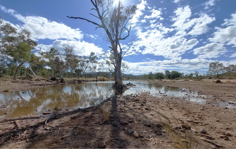
Day 13 - Finke River
29
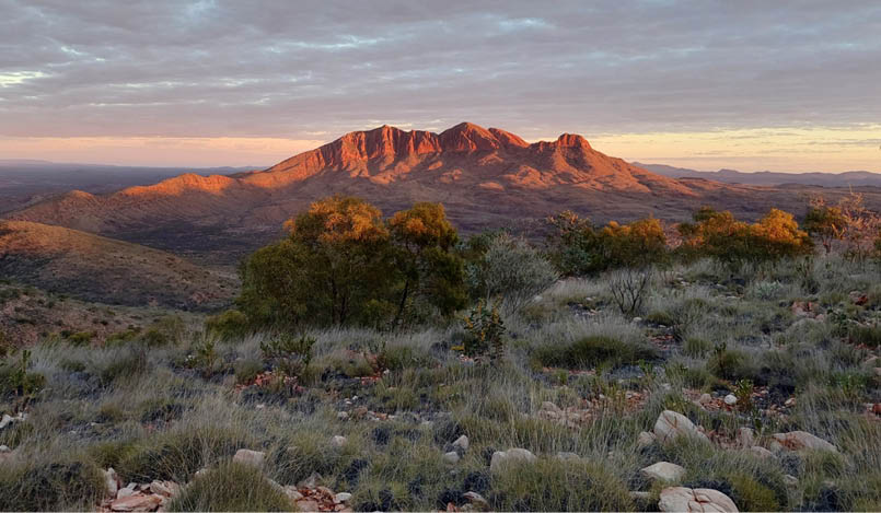
Day 15: Mount Sonder return Mount Sonder, known as Rutjupma, is called as the pregnant lady due to its shape. It has many tracks of the Dreamtime ancestors from Western Aranda people. This is the story of Mount Sonder from the information board, prior to climbing. A man/Euro (Hill Kangaroo) dreaming. The central figure was originally a man who came from the sand plains 300 kilometres to the west. On the way to Rutjupma the man, now turned into a euro, passed a collection of rocks. There a party of men looked up and saw him. From earth to sky, these men are touching that connection says the custodians.
It was a 3.30 am start today to watch the sunrise from the summit and it was so worth it. After returning to camp and having a rest I went back up to Redbank Gorge and found myself a small waterhole to swim in. It was cold but so refreshing. It was a fitting end to the trip.
Day 16: pick up, home and summary The pick-up van is scheduled for 10.30 am and Gina, Monty, Else and I headed back into Alice Springs. I got in contact with a friend of mine, Girija, who has been living in Alice Springs for the last year, so after a bit of a rest we all meet in town to have dinner. The next day I flew home and back to reality. What an amazing and stunning trek this is. The colours and variety of scenery of the desert are just beautiful. If you are thinking about doing this walk, stop thinking about it and do it.
Day 14 - Mount Sonder at sunrise from Hilltop Lookout
"
What an amazing and stunning trek this is.

"
Mount Sonder, known as Rutjupma, is called as the pregnant lady due to its shape.
30 | Bushwalk October 2023

Day 15 - Redbank Gorge. Yes you can swim through that gap
ResourcesYou can find more information about the Larapinta Trail on the official website or the national parks page. For more information about transportation contact Outback Elie tours, Larapinta Trail Trek Support or Trek support. Check the park's website about park pass fees and always book campsites before you go.
CostsThe walking fee is $25 per person per night up to a maximum of $125 per person, so after five nights the fee does not increase. Pay at Park bookings.
Most campsites have camping fees of $10 per night, except Standley Chasm which is $18.50. Pay at Park bookings except for Standley Chasm and Ormiston Gorge where you pay there at the kiosk.
Park fee NT Open Pass (valid 12 months) is $60.00, get this through Park bookings.
Food drop fee and retrieval fee per drop or pick up is $65, Locker key is $70 including a $50 deposit via Outback Elie tours or whoever you decide to travel with.
Pick up fee is $210 from Redbank Gorge to Alice Springs with Outback Elie tours or whoever you decide to travel with.
31