
After numerous aborted attempts I finally got around to doing the Fortress – Mt Thackeray circuit in a less visited corner of the Grampians. I tend to avoid the Grampians in summer as there’s not much water, it can be very hot and dry and somewhat fire prone. So June seemed like a good time to visit, especially with a dry and sunny forecast.

FortressMt Thackeray Circuit, GrampiansDrew Echberg aka Drew

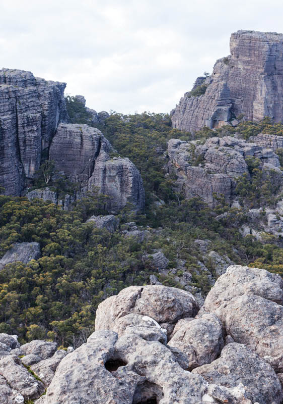
The FortressAll photos by Drew Echberg
44 | BWA February 2016
We drove up on Friday night and camped at near Buandik, about four hours from Melbourne via Dunkeld. There are a number of spots south of Buandik. You can camp at Buandik and pay $34 for the luxury of some grass, a toilet, a tap, a fire pit and a table to have your brekky at. And lots of grazing roos and wallabies.
On Saturday our starting point was at Deep Creek, which has plenty of flat ground for camping and a creek that may be unreliable in summer. Given that it’s meant to be a three day walk (and with the days at their shortest in mid-June), we thought we shouldn’t stuff around too much. We were walking by 8.45 am, early for us: early starts are not our forte. I’d read that Manja Shelter to Western Cave would take 3-4 hours, and another 4-5 hours to Mount Thackeray Camp, so we were expecting a 7 or 8 hour today even though we’d taken a couple of kilometres off by starting at Deep Creek.
After 90 minutes or so and a fairly steep climb we’d reached a spot just off the side of the track (a little scramble) with great views towards The Fortress, across the plains and with Mt Thackeray also visible. After less than two hours walking from the start we were at Western Cave. The creek was flowing nicely and there was a pretty waterfall. The next section of walking to Eastern Cave was really nice, with lots of rock formations, cliffs, some good views, a really huge weird earthworm and lots of bright orange fungus things.
Another half hour or so (including a rest to admire the views) brought us to Eastern Cave. There were better camping caves here than Western Cave, but a steep couple
of hundred metres of descent to get water, probably not flowing in summer or early autumn. Much to our disappointment we found that after descending from the Eastern Cave site we were walking on a road. I hadn’t looked that carefully at the map or notes and thought it was only the second day that involved road walking. It wasn’t the most exciting walking for the rest of the day, especially with the fire-damaged nature of the bush. But it was quick. We stopped for lunch along the way and arrived at Mt Thackeray campsite around 2.15 pm after collecting water at a creek that crossed the road a few hundred metres before the campsite. We must have eaten our Weet Bix that morning as it only took us around 5 hours instead of the expected 7 or 8.
The campsite was more or less a car camping spot, but thankfully no cars or other people were there. After setting up our tents and having a cup of tea we headed off for Mt Thackeray summit. With lots of brief stops for photos on the way up this climb took us 45 minutes or so. It was really beautiful country, classic Grampians, with amazing rock formations all over the place. Great views from the top too. Looking towards

Western Cave

Fungus
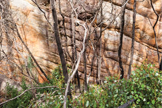
Burnt trees and rock face between Western Cave and Eastern Cave
BWA February 2016 | 45

View from Mt Thackeray south-west to The Fortress
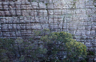
Rock face on the climb up Mt Thackeray
The Fortress across the rocky landscape I thought that surely, with a bit of effort (and budget), a wonderful dedicated walking track could be built that would pass through all those rock formations, rather than forcing people to plod along a road. I thought maybe the new Grampians Peaks Trail will remedy this. Later I found out that it won’t. Unfortunately the Peaks Trail bypasses this beautiful area.
We returned to camp and enjoyed a pleasant evening. Another pair of walkers arrived, making their rather heavy dinner with an enormous broccoli, a tin of coconut milk, glass jars of spices and various other heavy
ingredients. Oh well, they got more exercise than us with our dehydrated meal.
Despite being a clear night it was surprisingly mild - I could have left the winter sleeping bag at home! It appears that fires are not allowed. I’m unsure what the logic is. At Buandik there are “official” fire pits every few metres. At Thackeray There was an enormous fire ring filled with ash - clearly plenty of fires have been had there. The Grampians is a tinder box in summer but pretty damp and cold in winter. Maybe a blanket fire ban from November to April would make more sense.
On Sunday we left around 9.30 am. We collected water a few hundred metres down the road, and set a good pace, thinking of visiting wineries on the way home, perhaps. Apart from a few nice views it was pretty boring walking along the road. However, the bush will only get prettier as it continues to recover from fire (unless there’s another one of course). After seven kilometres or so we left the road and descended Hut Creek Track. On Chapman’s map a campsite is marked by the creek at the bottom of the descent, but it has mostly been reclaimed by weeds - it
46 | BWA February 2016

On the descent from Mt Thackeray
Drew Echberg is a Melbourne photographer. He grew up doing the odd bushwalk but over the last few years has become quite obsessed. Drew most often walks in the Victorian alps but has also walked in Patagonia, Nepal, West Africa, Iceland and various other places. Photographically he’s more interested in weird and ugly scenes than conventionally beautiful landscapes, but still lugs his heavy camera with him on most walks. The photos in this article were shot with a Canon 5DMkii with a Canon 35 mm f2 lens. You can see his photos at drewechberg.com
looked like there were more flat, clear spots after crossing the creek. The next section was fairly pleasant, criss-crossing the creek and enjoying the sunshine. Unfortunately though there are lots of weeds around. After a few kilometres we came out on the Buandik road, which we followed for a few hundred metres to get to the Manja Shelter Car Park. We continued on to Manja Shelter, where the rock paintings are very faint and rather underwhelming. The ugly security fence also detracts somewhat from the experience. It’s a shame that the indigenous cultural heritage attracts vandals and the fence is necessary. We had some lunch basking on the rocks and then followed an overgrown track back to our car, finished by about 2 pm.
We walked 29 kilometres in 10 hours including breaks, with 1456 metres of ascent and descent. Not a bad walk but not amazing. Typically for the Grampians, there are some really nice sections but some pretty dull sections of road bashing, made worse
by the fire damage. Unless you’re driving up from Melbourne (or somewhere else far away) and starting on the same day then it’s really only a two day walk. If you camped at Western Cave you could spend a lot of time exploring and rock scrambling in that area. It could be quite fun but potentially a little dangerous. It could also be great fun to go off-track from Mt Thackeray west towards the start, but I’ve got no idea how slow and difficult the going might be - you might end up lost in a maze of rock formations.


“... a wonderful dedicated walking track could be built that would pass through all those rock formations ...
BWA February 2016 | 47