Budawangs at Their Best and Worst
TextRobert Wildman
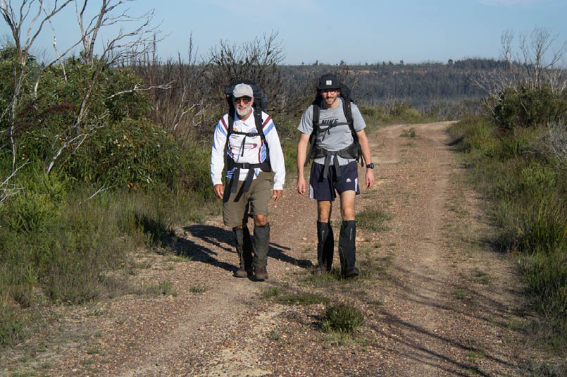
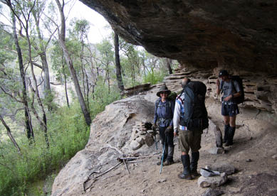
Frank and Josh on the road bash to Newhaven Gap

Walkers: Rob Wildman, Helen Jones, Frank Neri, Josh Neri
11-14 March 2023
The decision to do a four day loop in the Budawangs was not taken lightly.

16 | Bushwalk June 2023
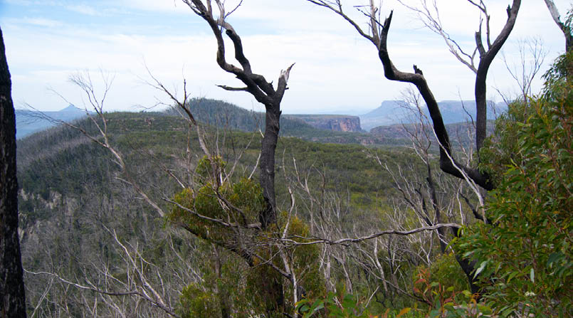
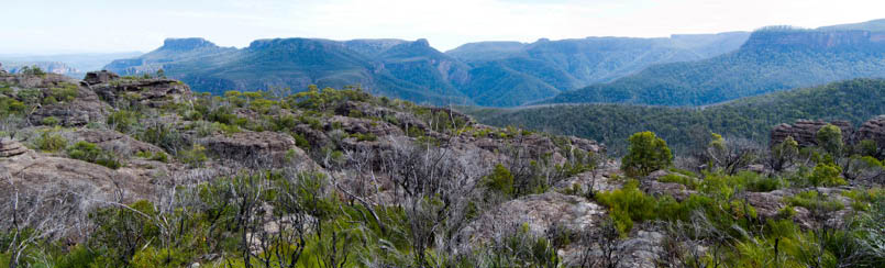
Pigeon House on the left and The Castle on the right from Graeme Mitchell Lookout
Like many other walkers throughout NSW, we had been struggling to deal with the loss of many of the old tracks and finding nothing but uncomfortable conditions since the rains which followed the fires in 2019. For a short time, it was heaven getting into areas, like Ettrema, where the thick scrub was wiped away and we could breeze through areas we very rarely dared to approach.
But with the loss of the canopy in most of the forests came the growth of an amazing list of ground plants and nursery trees, like acacia and quick-growing gums. As well, the growth of vines like hardenburger (that one with the lovely purple flower) and lawyer vine (so aptly named) were now unimpeded in their spread across the forest floor.
So the questions about going back into this wonderful area were about our ability to be able to actually get through. In December of 2021, due to the atrocious scrub we turned back on a walk into the Claydons Creek area after walking just 3 kilometres in three and a half hours. What could we expect this time?
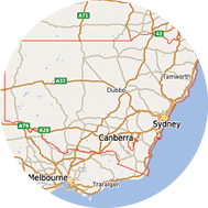
Driving inTo get to this magical place, one has to head south-west from Nowra on the Braidwood Road. After about an hour’s drive, at Sassafras, on top of the range, we turned left onto a very bumpy 2WD track. To our delight, the numerous frustrating gates had been dispensed with and the surface had been tarted up somewhat; it didn’t compare to the boggy, boulder-filled track which took walkers in for many years. From the picnic area at the locked gate 3 kilometres from the main road, it is now a 7 kilometre road bash to Newhaven Gap, which used to be the adopted camping area before the Budawangs Wilderness Area was proclaimed in the Morton National Park. This is where the Folly Point track, which has been maintained by the Coast and Mountain Walkers since 1965 (thanks to them), veers off and follows the ridges for another 8 kilometres to the jumbled, convoluted, but totally fascinating spot called Folly Point at the end of the ridge.
17
Day 1: Sassafras to Folly Point, 16.6 km, 6.3 hoursWe left at around 8.30 am from the car park under a cloudy and humid morning and hit the walking track at around 10.30 am. From what we had read, it would seem the track has had some shepherding into shape for most of the way but may descend into scrub towards the end. Clearly, the track has had work done on it and for the most part was a joy. The regrowth of Australian native grasses, where there had only been banksia, hakea and other unfriendly plants, made this surreal. Page 17 is the view from Graeme Mitchell Lookout on the Folly Point track looking south, with Pigeon House (Didthul) on the left and The Castle on the right. These views are only possible now after fires. We ambled through delightful fields until the rock platform started breaking up and we had arrived at the first night’s camp. Our only companions on this stretch of the walk were some big buzzing march flies which we dubbed the “B52’s”.
Did I mention the baths? Folly Point is unique in that just next to the camp spot runs a small stream which makes its way off the plateau via a series of small waterfalls with very deep pools below them, each of them about two
metres in diameter. They are perfect for the after walk freshen up and in several of them you can immerse yourself completely without touching the bottom.
Day 2: Folly Point to Angel Creek, 10.5 km, 8.25 hoursWith an overcast day and cool conditions, we found that the route to Watson Pass was quite easy to follow and by now there was a better pad showing the way. This pass is one of the best for sheer beauty and exhilaration. Clambering down the iron spikes and into the exit gully, the leaf litter and presence of rock orchids gives this an atmosphere not unlike the Green Room in Monolith Valley. The route down has several sections where pack passing is necessary and an ability to scramble through tight fissures is helpful. Daunting at first, the way is actually quite easy and you drop into a beautiful gully with walls covered in multi-coloured lichen and overhanging ferns.

"
This pass is one of the best for sheer beauty and exhilaration.


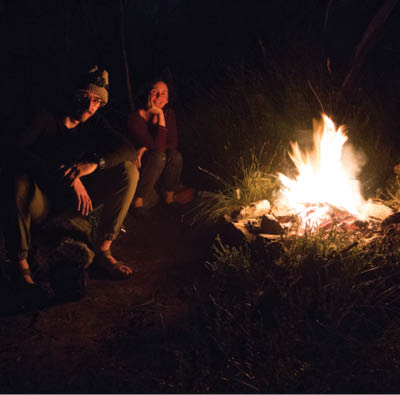
Josh and Helen enjoying the fire at the Folly Point camping area

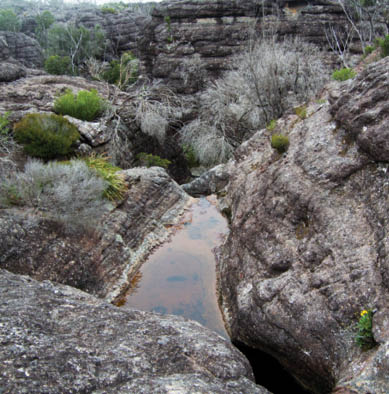
The bathing pool with a view at the end of Folly Point - fabulous after the walk
18 | Bushwalk June 2023


This map is © Bushwalk.com and is created using data © OpenStreetMap contributors
Budawangs
Road, four-wheel drive track, walking track (treed)
Main track, side trip, alternative route
Cliff, major contour line, minor contour line (50 metre interval)
Lake, river, waterfall or creek


0 km 1 2 3 4 5 km

Start of the walk
Campsite
Toilet


19
We followed the gully to the external cliffs and then glued ourselves to the walls in attempting to get to the corner before the drop down. Of course, with very few traces of anyone else having been there, we went too far but decided we would just head down trying to reach the cave in the cliff 500 metres below. While this was a lovely clear spur once, it was now so thick with regrowth and vines that we
hauled out the secateurs and attempted to make a path. About half way down we came across the three large boulders which have been a signature feature of this short spur, surrounded by a clear, leafy patch complete with old cairns guiding the way.
When we reached the cliff above the cave, we saw that what remained of the original
View from Folly Point with The Castle on the left and Hollands Gorge below

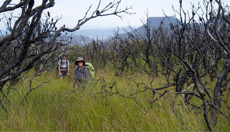
The Folly Point track with new grass growth and better views than before the fires
20 | Bushwalk June 2023
glade that surrounded the stream was totally destroyed by fire and was stark with fallen logs, loose scree and patches of dead scrub.
Dropping into the cave, the Illawong Venture scouts had kindly left an exercise book for fellow walkers to record their adventures. A busy place it was not, having the last entry sometime in 2022. However, some recognition of other bushwalker names gave us some comfort that we weren’t alone.
The task now was to sidle down to where the stream opens up and provides a flat shelf for us to cross to the other side and traverse to the ridge which leads down to Hollands Gorge. Again, where this had a clearly marked track once, nothing was left of this, making crossing the boulder-filled rills which flowed down from the walls above, quite difficult. At least the scrub had eased up.
"
... one of those gems in a sea of difficult country ...
Helen in the exit gully at the base of Watson Pass, on the right
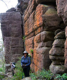
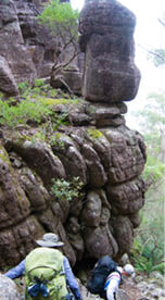
Helen, Frank and Josh in the camping cave half way down from Folly Point to Hollands Gorge

Frank and Helen in the exit gully from Watson Pass
Turning towards the creek we met our old friend; the scrub. Once off the very steep section, it was probably no more than 400 metres distance to the creek and flat ground but vines and downhill didn’t go well, with most of us taking falls. Unexpected falls like this sap confidence quickly, so reaching the creek became a desired necessity to reduce our anxiety about the rest of the trip.
We lunched just next to the old camping spot at the junction of Camping Rock Creek and Hollands Creek leaving this watery dell around 3 pm to head up the gorge.
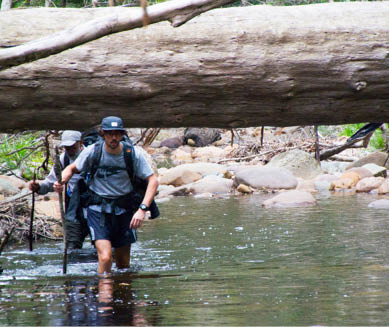
Hollands Gorge is one of those gems in a sea of difficult country that just lets you relax and enjoy the sheer beauty of your surroundings. The creek was up high enough to force us to wade all the way but we weren’t complaining, enjoying the cool clear water swirling around
our ankles, finally arriving at Angel Creek at around 5.15 pm. I had passed through this delightful camp spot twice before on other walks promising myself that one day I would return to actually camp there.
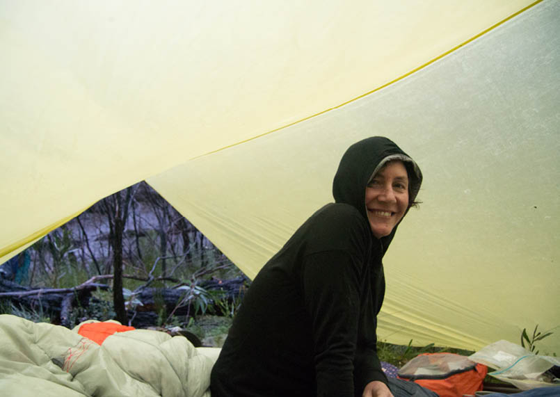
While we couldn’t see the clouds through the foliage, we could feel the humidity close in on us and knew we were in for some rain. We had time to organise ourselves, have dinner, a discussion on the state of the world and a swim in the big pool before tucking into bed. It came about 8 pm and was light but consistent, with a reassuring tap tap on
21
the tarpaulin. In the morning, we realised we hadn’t constructed our wet cover that well the night before so we woke to find everything at the bottom of the shelter had got wet, including our sleeping bags and dry clothes. A good mood starter for what was another big day!
Day 3: Angel Creek to the Sturgiss-Elliott Saddle, 4 km, 7.5 hoursAnd then, a request was shouted from the other tent: “Wildman, I think we should set off the EPIRB!” With the experience of the scrub from yesterday and the prospect of worse today, add a topping of rain, the plea at first seemed reasonable. But we were at the bottom of a very steep valley, none of us was injured and we had enough food even if, in the end, we decided to exit via the same route. The underlying issue was the potential for an injury or getting stuck on a ledge on Sturgiss Mountain. We huddled down, tensely discussed the pros and cons, and emerged not entirely happy but most voting to go on.
Climbing outOvernight the creek had risen by at least five centimetres making the few hundred metres back down the creek to our ascent ridge a lot more dangerous and slippery.
The route up the ridge to Mount Elliott was off track, steep and full of incredibly thick, viney regrowth which meant we were using the secateurs all the time and stopping
while we untangled ourselves. A sense of claustrophobia takes over as you stand amongst the dark mass of bush dwarfing you while waiting for the lead walker to push on. There was some apprehension in the group at this stage as we had no idea where we would find a camp spot in this country. We’d thought we might reach the relative safety of Hidden Valley but that was still a very questionable destination.
Half way to Mount Elliott we reached a set of cliffs straight in front of us barring our route. Luckily, the topography of the hill made it possible to traverse to the left and work our way back up to the ridge a little higher. Above the cliffs lay a flat plateau of burnt banksia and wonderful grasses but this time with a view to kill. Looking to the west we could make out Styles Creek swamp and then all the mounts circling around to The Castle in the distance. On the other side, we could see the cliffs we came past yesterday on Castle Head all the way back to Folly Point.
"
A sense of claustrophobia takes over as you stand amongst the dark mass of bush dwarfing you while waiting for the lead walker to push on.

Angel Creek Pool

22 | Bushwalk June 2023
When the slope kicked up again towards Mount Elliott the regrowth returned and we bashed our way to the cliff edge and lunch under a rock overhang. The rain had restarted an hour before and was now relentless. A can of tuna doesn’t quite do the trick when you are cold and wet with more to come.
We worked our way around the cliff edge, which was of course full of ups and downs with thick growth interspersed with open spaced areas at the foot of the massive cliffs above. Turning the corner of Mount Elliott revealed a fairly flat and grassy section which went all the way under the tsunami-like cliffs above. We even found an open cave which could have served as a camp for the night. Finally, we approached the narrow mouth of the entrance to the saddle between Mount Elliott and Sturgiss Mountain with ominous cliffs closing in all around. The sheer scale of the place filled us with awe. The climb up to the saddle sapped most of our remaining energy until we popped out onto a clear rocky area right in the centre of the saddle. By now it was 4 pm and we couldn’t possibly attempt a crossing of Sturgiss Mountain in the rain and the mist, so camp was made. In the end, despite all having misgivings about our situation, after the gardening was done it was a nice spot. Water was plentiful, given the rain that was streaming off the rock walls. We knew this would not have been the case
if it had not been raining, but another water source existed in the cave we passed on the way to the saddle. Worn out, we each settled into our shelters, scoffed the laksa for dinner and listened to the spats of rain which continued for most of the night. Finding a spot to camp with enough water for the night was a stroke of luck, not to be relied on in other conditions.
We did the sums on our day’s effort: 7.5 hours to walk 4 kilometres! Ouch!
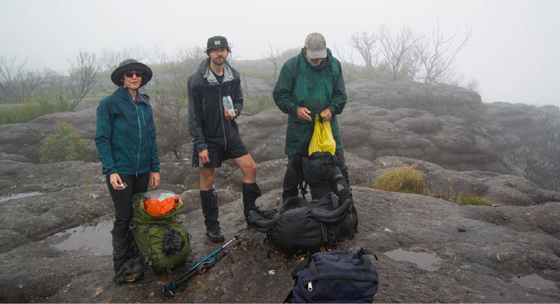
Day 4: Sturgiss-Elliott Saddle to Sassafras, 21 km, 12.5 hoursThis sounds like a cheap novel but it was a bright and sunny morning with the sun striking the walls of Sturgiss Mountain, towering above us to the west. The saddle was really a special place. We knew we had a big day so we were ready and walking by 8.10 am. The first target was to find the “staircase”, a sloping fall of rocks and earth which conveniently leads from just north of the saddle to a point which allows access to the top. But the access is via a scramble of roughly five metres which is quite hard even in the dry. In the time it took to get to this point, the clouds had quickly moved back in and the fog was starting to descend. Using a rope was the only way to get all four of us up with packs, slipping and sliding on the now wet surfaces.
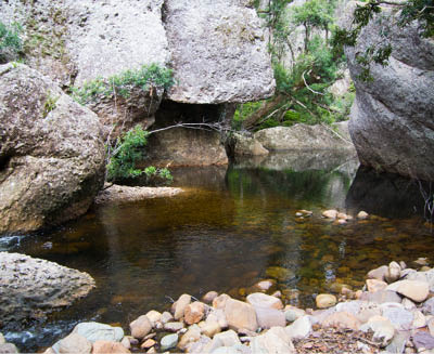
About an hour up Hollands Gorge is this constriction with a beautiful pool in the middle
Josh and Frank wading up Angel Creek just before camp
23
It took us around one and a half hours to reach the top of Sturgiss Mountain.
While Ron Doughton in his guide book Bushwalking in the Budawangs suggests never to walk on Sturgiss Mountain in a fog, we had other ideas – well, we had no choice if we wanted to get out.
On top we spent the first 3-400 metres passing through a belt of thick growth, even though the fires had eliminated the tough
banksias from the mix. Once on the rock platform on top, we got confirmation of a route from a set of cairns which started just as we broke into the open, and followed this spaghetti line across a narrow isthmus and onto the last platform. Picture this: flat rock platforms with long shallow pools of water broken by small patches of black burnt bush, festooned with thousands of intricate spiderwebs loaded with water droplets, and the contrasting yellow of the new grass growth. We were walking in the clouds. Even though we were wet through and cold, we could still garner some excitement for this amazing country.
"
We were walking in the clouds.


Helen under the tarp at the Elliott-Sturgiss saddle camp
"
This sounds like a cheap novel but it was a bright and sunny morning ...

24 | Bushwalk June 2023
The route then went down a gully, which looked like several we had passed already. We descended gently until we met a two metre drop down to a wide ledge beyond which there lay a thirty-nine metre fall to the valley floor. Given the “narrow ledge” description of part of the route in Doughton’s book, we headed off to the right on the ledge as this appeared to be the correct direction. It did go for quite some time broadening into a large expanse and narrowing to a point where crossing the gap above a hole was truly a frightening experience. Is this what Doughton meant when he said you needed a “head for heights”? We bumbled around at this high level, constantly following what looked like possibilities to get down and which all ended in dramatic drops. Defeated, and surrounded by low mist and rain, we considered setting off the EPIRB and waiting for a mythical chopper rescue. “Give me half an hour,” I said and took Josh with me to see if we could find the lost cairns. We went right back to the first contact with the ledge and this time went left. Within seconds there was the magical pointer to the correct way down. This led through staggered ledges down to a final short slide, complete with the old track taking off into the scrub ahead, at last on the valley floor. This slide was more difficult than it first appeared and I suspect this is the spot where Doughton mentions getting assistance from a chain, which is no longer there, perhaps melted during the 2019 fires. We had wasted nearly an hour on top; we knew we couldn’t afford this amount of time but while energy was fast disappearing, resilience, relief and humour were taking over.
The way from here back to Camp Rock was once a quick and enjoyable shady, cool walk. This time however we would take many more hours than we expected. Hidden Valley itself is now full of regrowth and we ploughed our way to the exit which, surprisingly, was much
the same. Even the track was visible and we started zooming along; we made all kinds of fantastic estimations of our arrival time, shower, beer and dinner by maybe 7.30 pm. As soon as we passed the old Hidden Valley camping spot, now unrecognisable, the track descended again into much thicker scrub. We were lucky we had an old GPS track guiding us through this as the scrub just seemed to go on and on. We finally reached the old timber-getters road, recognisable only by the cleared forest floor, not more than five hundred metres from Hidden Valley itself.
We expected again to be able to follow the now well used pad but it took us three attempts to find the right one even then. The track moved us on a slightly downhill route and for the most part, kept going. Every now and then it would just stop, usually because of a fallen tree, and we would be back in the thick of the regrowth again until we dropped out onto the worn path again. When the slope started to descend more sharply, we knew we were finally heading down to the beautiful, fern-filled crossing of Kilpatrick Creek. In better weather this would have been a delight. With the rain back again, we took a minute to have a cool drink and rest before our last section to the road near Camp Rock.
But we weren’t the only ones out with the rain. The creek valley was a haven for leeches and Frank and Josh, who were wearing only shorts, were copping them one after another on their exposed legs. Everyone made friends with them, even Helen, who seemed to only attract them to her stomach. Grimacing, she would lift her top to allow us to rip them off.
Here the path follows the old road much closer as it passes through quite steep gradients and several more creek crossings, by this stage getting deep and dangerous.
"
Within seconds there was the magical pointer to the correct way down.
"
The creek valley was a haven for leeches and Frank and Josh, who were wearing only shorts, were copping them one after another on their exposed legs.
25
The initial sections of this road were generally enjoyable but more and more we found ourselves crawling under fallen trees and losing the track as it passed through thicker scrub. At times, we couldn’t walk more than twenty metres before we stood perplexed in front of yet another massive tree blocking the track.
The next 4 kilometres would probably be the hardest to mentally endure. We were all getting very tired by this stage and when the track just stopped, leaving us bashing through scrub again until we crossed it at some point, the levels of enthusiasm were very low. At one point, poor Josh, who had done so much of the leading, had come to a standstill when the track yet again disappeared, a look of
complete despair washed over his face, and it was only through Helen spying the track behind him were we able to push on. This time we didn’t lose the track and finally at about 5.15 pm we broke out onto the road just before The Vines. We were all freezing as the rain had not let up and our reserves of energy were now at such a point that even walking wasn’t keeping us warm.
So now it was just down the road to the car! Just 13 kilometres down the road. Only more surprises lay in store. The NPWS had decided to repair this old road and from Camp Rock to Newhaven Gap, a distance of about 3 kilometres, we encountered new blue metal which had been laid on the road to assist in the boggy sections. Not little blue metal but boulders – well it seemed like that at the time, making us search out the smoother sections on the sides.
Again, we were fooling ourselves into believing we would make the car by 8 pm at the latest. About half-way back, with about 4 kilometres to go, we discovered that a grader had trimmed the surface. With the rain, which
Helen, Frank and Josh take a break from the fog and rain on top of Mount Sturgiss just before the descent
"
The next 4 kilometres would probably be the hardest to mentally endure.
26 | Bushwalk June 2023
had been falling on and off for more than two days, the road was now starting to look like a World War I trench. As we turned on the head torches, which mainly only showed the rain in front of us, we started slipping off to the side and kept trying to find the driest part with very little success. The last insult was the final hill up to the car; slipping and sliding we arrived at 8.30 pm caked in thick mud. But with the car facing downhill away from the way we wanted to go, our next fear was that, after all this work, we would get bogged with no reception.
Luck was on our side at this point and we were able to turn around. Except for the thick fog across the top of Sassafras Hill, we crept our way safely back to the welcoming bright lights of Nowra.
We had spent inordinate amounts of time and energy to cover what was actually a short distance in the end (like 12.5 hours on the last day alone covering 21 kilometres) and while I know the Budawangs can never be underestimated, this was probably my hardest and riskiest walk in this area ever. It was, in the end, a challenge for all of us. We often questioned whether we could go on or simply turn around but as the conditions got worse and worse, we just had to find the resilience in ourselves to keep moving and just get there whatever it took.
It was the Budawangs at their worst but despite all this, we had seen fabulous country, castle-like cliffs disappearing into the fog above, superb camping spots and serene glades along the creeks. And we learned just that bit more about each other.
In the
News
NSW Great Koala National Park to go aheadThe Great Koala National Park proposed more than a decade ago is now likely to become a reality. The proposed GKNP would connect 175,000 hectares of state forests with existing national parks, creating a nature reserve of more than 300,000 hectares.
Alone winnerGina Chick, the winner of the SBS Alone Australia show reflects on her journey into wild existence.
Around the world for nearly 10 yearsIn October 2013 Thor Pedersen of Denmark set off to go around the world without using any planes. He recently finished his trip and documented it all in his blog Once Upon a Saga.
Platypuses return to Royal National ParkAfter more than 50 year's absence at Royal National Park, platypuses have been re-introduced there by UNSW Sydney scientists.

27