"

Reflections on The Eastern Arthurs
TextBede House
PhotosRob Deed
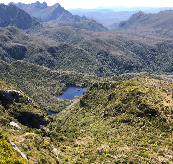
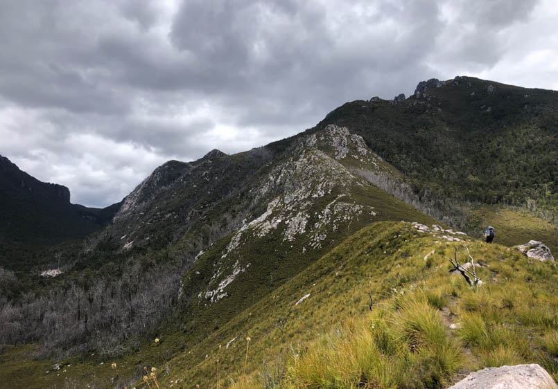
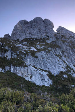
The Dial, The Boiler Plates and Lake Gaston from the top of the Southern Traverse
Walking is an individual thing, and each walker's goals are so personalised that it is impossible to list walks from worst to best. However, it cannot be refuted that few walks garner such respect as the Eastern Arthurs. This is because it is a place that resisted human overrun longer than many peaks in the Himalayas, and almost as long as Everest. It took many intrepid and unique characters to reach the greatest of the Eastern Arthurs crags, Federation Peak, and to traverse the range itself.

4 | Bushwalk June 2023
I am now 18, and I have finished school and am about to embark upon a degree. To complete this pivotal period, I felt it was time to pit myself against this beast, and in particular the jewel of the range, Federation Peak. The plan was simple: traverse the range - Scotts Peak Dam to Farmhouse Creek - and climb Federation.
I enlisted two people. The first was a relative whose title is rather unclear, so I just call him Drew. He is a passionate walker, and good company. The second was my Uncle Rob, with whom I had scaled Mount Anne the previous year.
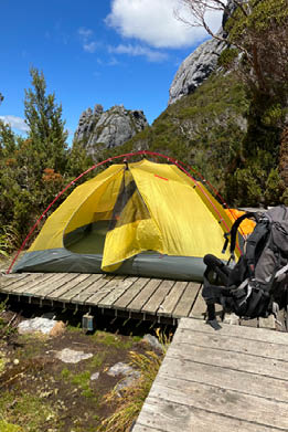
Day 1: Scotts Peak Dam to Cracroft Crossing, 26.7 km, 8.5 hoursI had been religiously watching the weather forecast for days. At first it was really rather bad, but it quickly became clear that it was all a hoax, and the weather was actually going to be rather good, with a prediction of a little rain on the third and the fourth days, but very sunny after that.
I talked often with the team, and everyone was ready to go on the morning of 3 January 2023. We left early from The Huon Valley in light drizzle, and picked up Drew from the St Ives in Hobart, arriving at the dam at 9 am.
It was a slow start. We chatted, holding off saddling packs for as long as possible. The loads weren’t getting any lighter, and it was three grimacing men that signed the log book at the start of the track proper and made their way over the first, wooded, knoll. We made swift progress initially, but it was no more than five minutes before we met our first person, an education ranger.
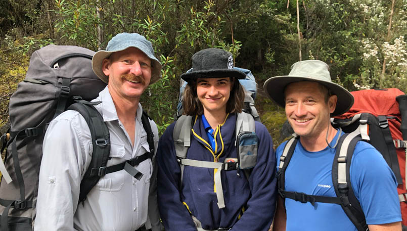
Uncle Rob, Bede and Drew
"
The plan was simple: traverse the range - Scotts Peak Dam to Farmhouse Creek - and climb Federation.


5
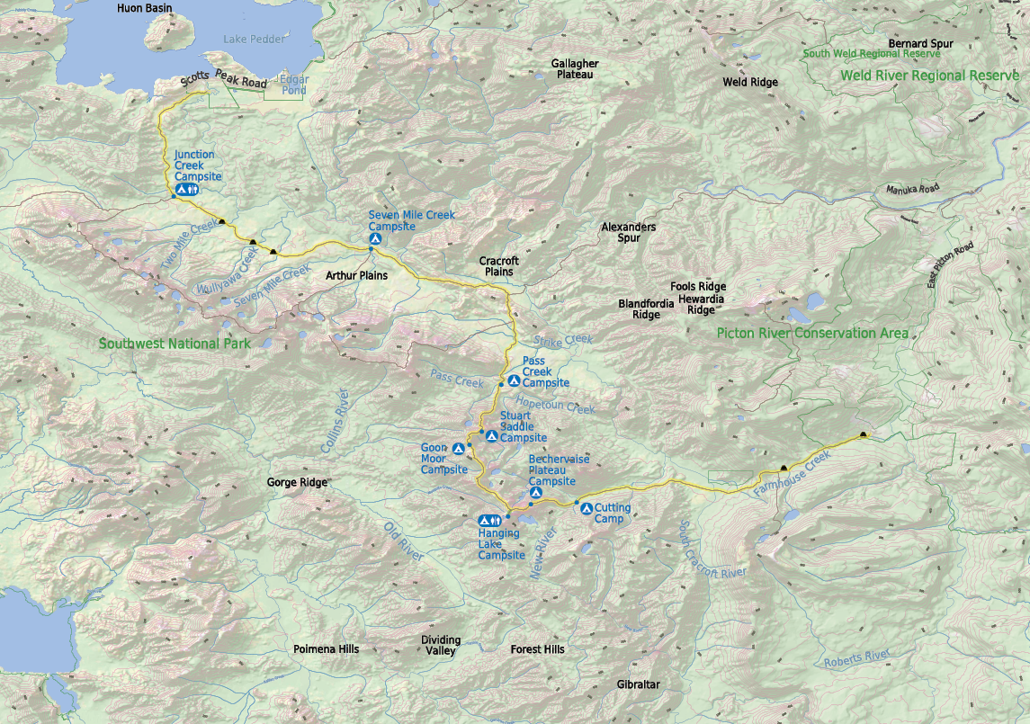


Campsite
Toilet
Start of the walk


Bushwalk.com notes and maps on webpage, GPX and PDF
This map is © Bushwalk.com and is created using data © OpenStreetMap contributors
Road, four-wheel drive track, walking track (treed)
Main track, side trip, alternative route
Cliff, major contour line, minor contour line (50 metre interval)
Lake, river, waterfall or creek


Eastern Arthur Range Traverse


0 5 10 km


6 | Bushwalk June 2023
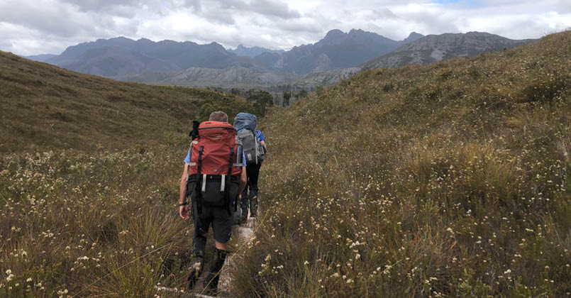
The forest continued unabated, until suddenly we came out onto an open buttongrass plain dotted with small, grassy knolls. This is a plain like few that I have ever seen, deeply rutted with small soaks rather than being merely a flat expanse. My grandfather left us and wished us good luck. We were now in the thick of it, and there was no turning back. We crossed the small plain over a two kilometre stretch of board walk alternating with loose gravel until we plunged once more into a thick enclave of trees. What followed was a mottled affair as we moved through thickening and thinning scrub and forest with many small creek crossings.
Up to this point we had neither gained nor lost significant altitude but finally we began to descend until we reached Junction Creek. The time was 11 am and we were ready for a cup of tea. It was here that we had the first of a number of unsettling encounters. A large group appeared and after a little chat we mentioned we were off to Feders where they too were going. “You going to climb it?” he asked. “That’s the plan.” “Cool, I climbed it once, but I’m too scared now.” Tea was silent after that until we decided to be on our way.
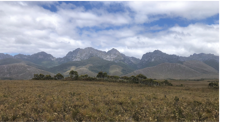
The next stretch was the long Arthur Plains. It was a continuation of the plain walking we had already done, except for the fact that you were accompanied by wonderful views of the Western Arthurs and that the amount of forest encountered significantly reduced.
The sun had come out now, if only for a minute, and the plains had heated up to a balmy 17 degrees. We sweated our way through and were relieved as it began to cloud over a little and abate the full force of the sun. We crossed many small creeks and trudged through much mud and knee-high scrub as we made our way toward the mighty Razorback which could be seen off in the distance.
It was about an hour and a half after leaving Junction Creek that we met a rather enthusiastic young rover. He told us that he had come off the Western Arthurs at Moraine K and was heading back to Scotts Peak, and when we mentioned we were headed for Federation he said, “Oh yeah, I have been eyeing it off the whole walk. It just wants to be climbed. It’s just been there, this big sexy mountain.” A big sexy mountain indeed; I will never think of it any differently.
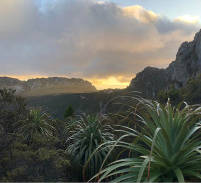
The Western Arthurs from The Arthur Plains

7
We crossed more creeks and plains, heading east until we hit Seven Mile Creek where we stopped for a late lunch at 3 pm. Here we debated as to whether to continue or to make camp, as I had travelled the next section the previous November and it had taken four hours. We decided that if we walked hard we could make it by 6 pm.
The track headed along the plains a little further before scaling The Razorback, an open ridge separating the Cracroft and Arthur plains. We reached the top after 90 minutes and stopped briefly to take in the view. The wind had picked up and the clouds were lower in the sky. The outlook was altogether bleak. We quickly saddled packs again and made our way down the slow descent which runs along the flank of the Razorback ridge to the junction with the Huon Track. Here, it began to rain so that the last 200 metres were in light drizzle, which went unabated until we were in bed. We had Burritos (except for Drew who had a dehyd), a G and T each and decided on a leisurely start the next morning.
Day 2: Cracroft Crossing to Stuart Saddle, 10 km 8.5 hoursDay two dawned overcast but dry, but we still made a late start, around 9 am. The weather improved as we mounted the Razorback further east and got our first view of Federation Peak at the low saddle.
The descent and then the long amble parallel to Strike Creek was difficult as disuse of the track by walkers and confusion from numerous faint animal pads impeded progress, so that it was a frustrated party that finally found the track on the opposite bank later than expected. The track improved quickly, however, as we made our way to Cerberus Hill and found some delightful duckboard as we contoured around it into the valley of Pass Creek where we lunched in the hot sun, all the mountains staring down up on our exposed position.
The openness of the country was exciting, as one could see virtually all the way down the Pass Creek valley and all the way up it, as well as being able to spy the tall peaks around us, West Portal and the Boiler Plates being most prominent.
The Eastern Arthurs from The Razorback
8 | Bushwalk June 2023
Goon Moor and The Needles from Stuart Saddle
Luckmans Lead
We could also see the steep climb that is Luckmans Lead, so we had a long lunch, hoping we would be suddenly transported to the top. Alas, that never happened and we eventually packed up and made our way along more duckboards up along the left stem of Pass Creek. It was at the end of this narrow valley that we had another unnerving experience.
Two walkers were making their way off Luckmans Lead, and we met them here. After some pleasantries, I asked them if they climbed the peak. “We got up there and we were really tired and we were just like nah,” was the man's response. “It’s really scary around there,” was the woman's. More votes of confidence.
9
We continued along the duckboard towards the imposing ridge that was Luckmans Lead until we finally hit it, and began a steep and seemingly endless climb across an open slope. The track was rutted and large white stones were littered across the grass.
It was a slow climb until we finally came to a new weather observation system, which we had a great time procrastinating with. We continued up, finally, and entered thick forest, a particularly painful affair due to the roots and over growth constantly entwining itself in packs, and it was a relief to escape for a drink of water and a biscuit.
We then continued across more semi-open country to the boiler plates, entering a small glade where the Luckmans Lead campsite is, and where we stopped for tea. It was now 4.30 pm, and any hope of making it to Goon Moor was dashed, but we were determined to make it to Stuart Saddle.
The Boiler Plates loomed, and it was an impressive site as we made our way through these large slabs of rock, following a steep and at times mildly exposed route, an exciting but tiring affair. By the time we topped out I was buggered. Making our way around The Dial above the beautiful Lake Leo, shimmering like a jewel, was a slog, but we finally made it, and set up camp in brilliant sunshine, looking up at the impressive face of the western-most needles.
Day 3: Stuart Saddle to Hanging Lake, 7.1 km 9.5 hoursWe had hoped for good weather. We were out of luck. A heavy mist had descended overnight and a light rain was dripping. We lounged in the tent until it lightened a little, and went about breakfast. It clagged in so we lounged some more, before biting the bullet and packing up in the wet, donning heavy rain gear and beginning the tiresome but very exciting route underneath The Needles. We clambered up a boulder-strewn gully to the saddle in the middle of The Needles, and crossed to the other side, being teased by small views to the east as we went.
It was here that the weather showed some signs of fining up, but as we descended under the west side of The Needles, it clagged back in again and even lightly rained, and it was a dreary sight as we came into Goon Moor. Here I filled my water bladder for the first time, but it proved to be unnecessary weight, as 3 litres rather then the 6 would have easily sufficed. Crossing Goon Moor was a tiresome business, the buttongrass pushing back against our feet, and sapping valuable energy.
The climb over a small knoll to the east was rewarding, as by the time we came to the Gables the cloud cover was lifting, revealing the full splendour of the range, and Federation Peak lay in a cloak of mist, peeking through like an enigma.
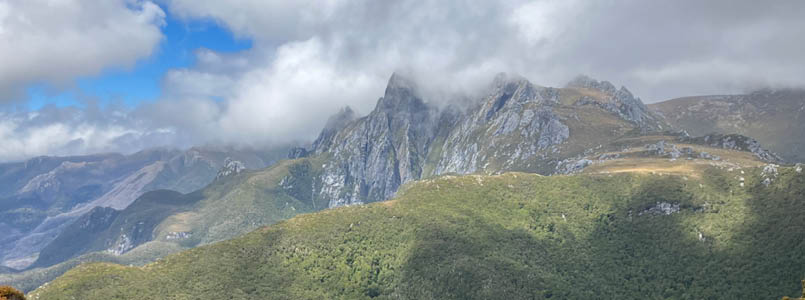
Federation Peak from the saddle with The Gables
10 | Bushwalk June 2023
It was a little after the saddle with The Gables that we had lunch, and the sun came out, drying our wet clothes and warming us up. Looking south there seemed to be no further cloud approaching, and we hoped this would mean a free run to the summit the next day.
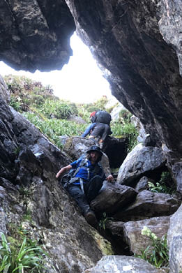
We were now entering one of the more difficult parts of the traverse, the Four Peaks, infamous for its technical climbing, both up and down, and for the slow going of the terrain due to scrub and constant rocky ascents and descents. We made our way over a small knoll, and got our first look at the first of the peaks, a bulbous rock formation like a belly. It all seemed easy enough until suddenly it wasn’t. A near vertical, razor-thin wall barred the way. Climbing over it with a pack was tricky enough, but then came a steep and loose descent down a steep gully.
It was like this for a number of hours, up tenuous ascents and down climbs whose technicality should not be underestimated as we contoured around the western side of the Four Peaks massif, until finally we came out onto easier ground around Thwaites Plateau.
After a slug of water we three weary travellers made the slog up Thwaites Plateau and passed the Devils Thumb, taking a moment
to enjoy the impressive scenery of the lakes below and the Forest Chute. We took this until we made it to the turn off with the Hanging Lake track where we stopped again and joked about a late afternoon ascent of Federation, an idea that was not without its merits.
The short walk to Hanging Lake was quite pleasant. After setting up camp a hot dinner was welcome as we looked out at the view, basking in the good weather, an incredible sight being a small wisp of cloud settling over the summit of Federation and glowing yellow in the dying light.
Day 4: Hanging Lake to Bechervaise Plateau, 2 km 6 hoursD-day dawned cool and clear, the perfect weather for a summit attempt. The pressure was on, and I felt it keenly as we packed up and made our way quickly back to the top of the main ridge. The path we followed was initially without issue, just a steep slope, and then we rounded a hunk of rock, and below was a serious drop. I stopped a moment, contemplating, before continuing on, hoping that was the worst. It wasn’t.
What followed was a thin razorback traversed by a series of climbs and descents poised ominously above steep drops to ledges

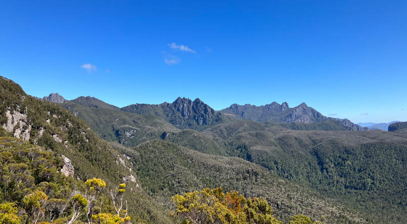
The Eastern Arthurs from the top of Thwaites Plateau
11
below, and below those ledges was seemingly nothing but the forest many hundreds of metres below. According to my uncle, it was looking more and more like Federation Peak.
To say it was an exhilarating experience is one way of putting it; scary was more appropriate.
But finally, we came into a group of tall spires and traversed our way through them and with that the country levelled out except for a brief climb across a steep gully. The country among the spires was impressive, and as we came between the last two, we got our first view of the direct ascent; looking up to where people attempting the most difficult part, coming out across a ledge with many many metres of exposure below.
As we came underneath it I felt much apprehension, but all that could be done was to go or not, and I decided I would at least try. We got together some essentials, and then started up. From the get go it was exposed, and it only got worse as we continued up. We sat down about half way up and marvelled at the steepness and the exposure all around us, it was as if we sat on a small blade amidst nothing. But up we must go and up we did until we came to the fabled ledge.
It was remarkably unmemorable as we made our way up the most exposed section, the infamous groove, and from then on the climb levelled out considerably, and it was a mere walk for the final 100 metres to the summit.
It was a moment I will never forget, to finally stand where I had always wanted to. This moment had been a goal since I was a child, an odd goal, but there we are. We sat around, made calls, procrastinated descending and basked in the joy of the moment. It was my uncle’s second time at the summit, and for Drew it was third time lucky. Thirty minutes later we began the descent, and other than getting a little lost we made it back down unscathed.
The sun was now heavy, and so we found a little shade and made lunch. It was a joyous time to sit and contemplate our victory and to frolic in the warmth. We had come a long way,

"
This moment had been a goal since I was a child, an odd goal, but there we are.

The tent drying at Bechervaise Plateau
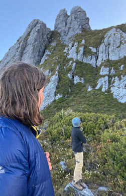
The author and Drew in Chockstone Gully
Looking up at the beginning of the Southern Traverse from Bechervaise Plateau
12 | Bushwalk June 2023
and it had not been for nothing now, as it very well could have been. Another hour passed and we packed up, and decided on a leisurely afternoon.
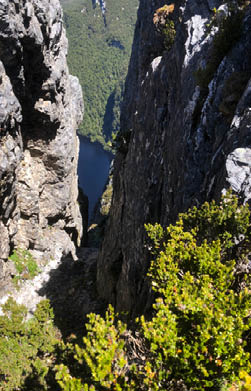
We made our way down Chockstone Gully enthusiastically, and took photos beneath the chockstone which gives it its name, before popping out at the floor of Geeves gully. It was here that we had some navigational trouble. It was clear enough that we made our way up the gully, but the question was whether or not to take the more exposed route.
We made our way up angularly so as to avoid the nasty drop, but quickly came to a dead end. To continue up required traverse across a very technical climb, especially with packs. Having decided that this was not the route we made our way down to the more exposed climb. It was simple enough from there, and we soon found ourselves popping out below the notorious climbing gully, “the original chink in Federation’s armour” according to Kevin Doran. It was on this little platform that I rang my father and told him of our success, much to his delight, and then we descended to Bechervaise where we lulled away the afternoon with cups of tea and tall tales.
Day 5: Bechervaise Plateau to The South Cracroft Campsite, 9.7 km 9.5 hoursWe woke to another perfect day, and set about breakfast and packing up quickly, eager to make the most of the good weather. We left at the usual time of 9.00 am, and made our way down to Lower Bechervaise where we ran into some fast people who had made it to that point in two hours from Cherry Creek. We chatted for a little while and then continued down.
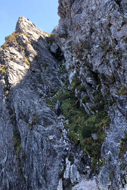
Moss Ridge is infamous for its up and down nature and its erosion, and we found just that. The most difficult section was to the top of the final tooth, where we encountered many steep descents and ascents, many bordering on vertical, and made very little overall downward progress. We sat at the top of the tooth and admired the peak and the ridge we had traversed. You could see everything, and we spent ample time dawdling to take it all in. It had also become hot, and as we descended the next section it got hotter.
The section to Cherry Creek was far steeper, and many trees lay over the track, impeding progress substantially. It was about half-way through this section we reached the Moss
The author and Drew descending to the floor of Geeves Gully
Federation Peak from Bechervaise Plateau
The top of Geeves Gully
13
Camp, a large divot in the ridge that provides ample protection from the weather. Having said that, getting both in and out of it is tricky, with near vertical climbs on both sides.
It was a long slog by the end, and we took a brief break only to be informed that our lunch spot was five minutes further on, but then apparently, according to another walker, it was 20 minutes, so who could tell? Luckily, it was not 20 minutes away, and we settled in at Cherry Creek for a leisurely lunch. In the valley it was hot, and the flies buzzed around us as we ate, trying desperately to take our nutrition from us.
We got back on the track again, following Cherry Creek to its confluence with the
South Cracroft River. It was pleasant walking amongst the tall trees, but eventually we were pulled out into the hot sun on the plains, and sweated until we came to a nice little creek where we dipped our heads in and refreshed.
Some passers by informed us of a helicopter evacuation at the South Cracroft River. A young man had fallen and dislocated his shoulder. His friends passed us, and fell in the creek on the way.
We descended through strange, deep ruts, before the final climb up to the crest range, and our final view of Fedders. The striking thing about this part of the walk was how damaged it was by the recent fires. The damage was terrible, the fauna was only just recovering, and the burnt scar sucked much of the natural beauty one is used to in this area.
We descended into the valley of the South Cracroft River, and staggered the last kilometres across the plains to the campsite, where we found a river choked with dead trees, with barely enough space for a swim.
The Eastern Arthurs from Moss Ridge
"
We descended through strange, deep ruts, before the final climb up to the crest range, and our final view of Fedders.

14 | Bushwalk June 2023
Bede lives in Brisbane, Queensland. He grew up in Tasmania where he got his passion for bushwalking. He likes bushwalking because it's exciting, allowing him to have many great adventures seeing the most beautiful and remote parts of Australia. It also gives him something to have a good chat about after the walk.
"
Day 6: The South Cracroft Campsite to Farmhouse Creek, 9.5 km, 5 hoursToday was a short day across the Picton Saddle and down to The West Picton Road. We had arranged a ride at noon so we left early, around 7 am in anticipation of a five hour walk.
The initial section crossed the plains of the South Cracroft valley. The country was scrubby, but relatively simple to traverse, with no significant foliage across the track. It was tantalising to see the saddle we wished to be in so close.
We soon came under the canopy of dense forest, the temperature dropped and the humidity increased, making for pleasant walking considering the now steepened terrain. We walked fast, discussing films and actors until we stopped for a rest close to the top of the saddle.
We came upon the top shortly, and began the deceptively long walk across it. The track became boggy and indiscernible in places, and it was a great relief to come across the top of Farmhouse Creek where we drank and downed a little scroggin.
It was a gentle walk down Farmhouse Creek. The sun was shining high by that point, and except for one small section the track was easy enough to follow. We met another party in the final moments before coming out onto the West Picton Road. We quickly filled a couple of water bottles and then walked 3 kilometres of the road as a landslide had made it impassable beyond a certain point.
We rounded a bend, a single figure coming towards us, clad in a red cap and a scuffed button shirt. It was my grandfather, the man who had taken us out six days before was here to welcome us home, a fitting, circular end to one of the most memorable weeks of my life.
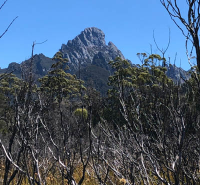
Federation Peak from The South Cracroft Valley

"
It was tantalising to see the saddle we wished to be in so close.

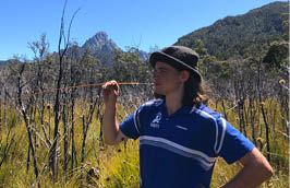
Bede being a dill in The South Cracroft Valley
15