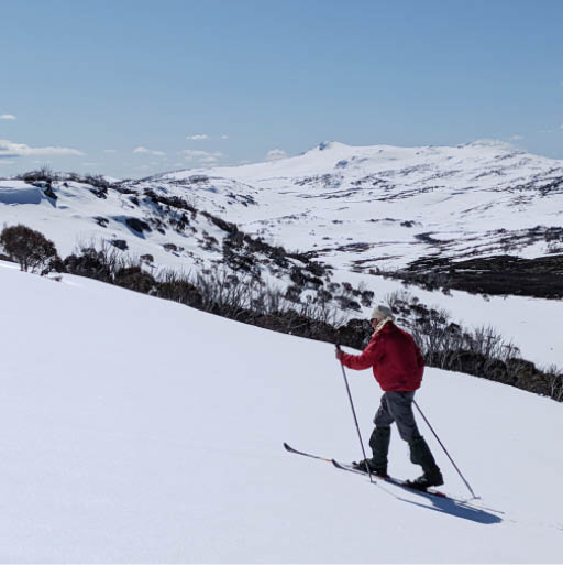
Gordon heading towards Mawsons hut

In the Shadow of Mount “Jugular”
Text and photosTerry Cornall
A wee bit of whimsical hyperbole and poetic licence in the title. Just a smidge.
This is a trip report for four days of alpine touring I did in the Mt Jagungal region of the NSW Snowy Mountains, with ski-buddy Gordon on 11/9/22. Remember 2022, when we still had good snow in September?

12 | Bushwalk February 2024
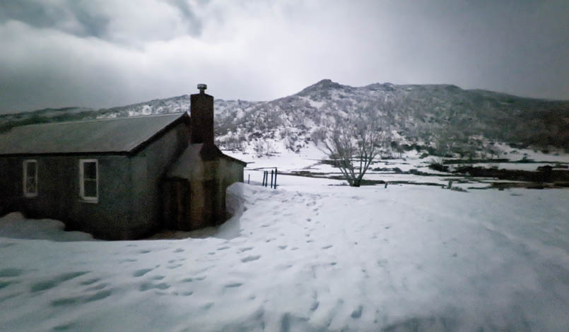
Whites River Hut from the dunny at midnight
We rolled into the Island Bend campsite not far from Guthega Power Station (GPS) on Sunday evening after driving up from Gippsland Victoria. After a lovely mashup of sausages and veggies we hit the sack under Gordon's basecamp pyramid tent. It was a bit breezy and chilly, but I was plenty snug in my Western Mountaineering Antelope GWS alpine bag. Despite being beaten about the head a bit by the flappy tent I got a good sleep, lulled by the rushy sounds of water from the Snow River nearby. The GWS stands for Gore Wind Stopper - although it adds a tiny bit of weight and also makes the bag a bit harder to compress, it adds water repellency and resistance to chilly breezes to an already great big poofy warm bag. Rated to -15° C I'd trust it down to -10° happily.
Day 1: Guthega Power Station to Whites River Hut, 8.2 km, 3 hrsWe rose next morning after sleeping past the alarm, a trend that I am happy to report continued for the entire trip. Packing up and
heading for the Power Station we arrived shortly and then got the trip truly underway. It was a bit grey and dreary, and that continued all day with short bits of sunshine. The snow conditions meant we could don skis only after a short climb out of the Power Station. We skied more or less without having to take them off more than a few times to cross gnarly bits where the snow had turned to dirt or been washed out by small tributaries. We had some navigating fun in the snow flurries and poor visibility, not at all aided by my photochromatic smart glasses, deciding that they should stay blacked out even though the sun was hidden. Cold will do that to them,
"
... not at all aided by my photochromatic smart glasses, deciding that they should stay blacked out even though the sun was hidden.


13

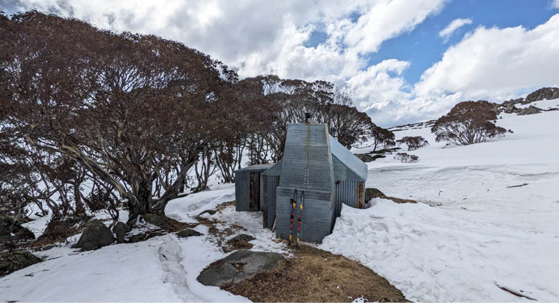
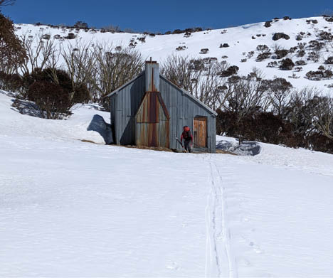
I have found. Eventually I swapped to better-behaved stupid glasses that just stayed clear all the time and then I could read the damn InReach Explorer+ satnav and Fenix 7 watch properly. More by good fortune and Gordon's instincts than my navigation, we did end up on the Horse Camp Aqueduct Track that stayed fairly high above the Munyang River. The only other adventurer about was a young chap with snowshoes who left the Power Station at the same time as we did. He made it all the way to Whites River Hut and met us again on his way back to the car park before we were even halfway to the hut. He was powering along on his snowshoes compared to us old plodders with packs on skis. A wee bit of decision making at the weir that marked the end of the Aqueduct Track, and then we were onto the Schlink Pass Road and a short hop from Whites River Hut. We considered going on to the Schlink Hilton, but decided that enough was enough and it was time for a brew and some sleep. We had the hut to ourselves that night. I took this photo from the dunny in the middle of the night, just lit by moonlight. I was amazed that it came out so well. Good 'ol Google Pixel 5 smartphone.
Day 2: Whites River Hut to Tin Hut, 7 km, 4 hrsOn the next day the weather was fine with a smattering of new snow, and the sunscreen and my buff came out to keep the sun off my head without being too hot. Gordon made do with a triangular bandage tied around his pate which made him look like an escapee from a trauma ward but served the purpose. I still managed to get the tip of my nose and my temples (where the snow goggles didn't quite meet the buff) badly burned. My small beard (grown over the Covid period as a sort of passive-aggressive protest at being locked in) helped shade my face, but I decided it had to go as soon as the trip was over. Somehow it had gotten the smell of garlic flavoured olive oil into it and it was like being followed around by a rancid pizza.
We were originally planning to go to Valentine Hut that day and then on to Mawsons followed by Tin Hut, but Gordon had a fortunate brainwave when we got to the bit just past the Schlink Pass where we could head on up to Mt Gungartan. "Why don't we head for Tin Hut today while the weather is

Terry at Schlink Pass

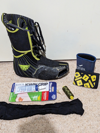
Some beer-holder derived neoprene, some glue and the toe of a stocking and no one has to know I hacked my boot-liner ...

14 | Bushwalk February 2024


This map is © Bushwalk.com and is created using data © OpenStreetMap contributors.

Road, four-wheel drive track, walking track (treed)
Main track, side trip, alternative route
Cliff, major contour line, minor contour line (20 metre interval)
Lake, river, waterfall or creek


Start of the walk
Hut
Campsite
Toilet
Parking
Waterfall
Summit

Jagungal Circuit


0 m 500 1000 1500 m


15
good?" I thought about it. It meant a sharpish climb to begin with but the beautiful weather made it an easy decision. "Let's do it," I cried and we donned skins and headed up. It was pretty easy going on the firm crusty snow, probably easier going up than it would have been coming down. It meant that once the climb was over, the rest of the trip would be downhill and it made for a relaxed tour. I'd recommend going anti-clockwise if you are doing the Tin Hut, Mawsons Hut, Valentine Hut, Schlink Hut circuit like we were.
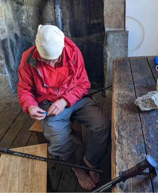
I had taped up my feet that morning, to protect the insides of my arches from rubbing raw by the Dynafit ski boots. It did work to an extent, but I feared I had made the tape too tight on the top of the arch and it was feeling a bit funny. It turned out later that it was actually tearing the skin under the tape there. Sigh. If it isn't one thing it's another with the dang boots. Why, despite being told multiple times that I needed to be able to tour in the damn things and not just go downhill, did the fitter insist that they had to be so tight, and why did I not insist on them actually fitting? I know better now, I suppose. I could also
feel (a pressure that would lose the toenail if it went on) that my efforts to punch out the plastic boots to give my little toe on the right foot some wriggle room, hadn't solved the problem and I resolved to attack the toe with a knife. The toe on the inner lining of the boot that is, not my precious flesh itself. This was a good decision and I didn't regret desecrating the boot liner. It turned out that the outer boot was fine, just the inner was a size too small! I could put a patch over the hole when I got home.
Once over the broad Gungartan Pass, we skied toward the bend where the hut was, trying to work out which patch of trees it was in. I spied its dunny on the far side of a clearing surrounded by trees, and headed straight for it, but was baulked by a cornice that I really didn't want to ski over (marked as avalanche zone on my map ...). So I had to traverse around a bit to where Gordon had found the correct line. We found the star-picket fence that I later worked out we should have been using as a turn reference (looks like I had the retrospective navigation turned on again). Then the hut became barely apparent
Tin Hut

16 | Bushwalk February 2024

Gordon halfway between Tin Hut and Mawsons trying to figure out which bump on the horizon was which
through its screen of snowgums. It would be very difficult to find it in poor visibility, hidden by the trees from the north and west approaches as it is.
Again we had the hut to ourselves and we were only too glad to settle in and have a brew. But it wasn't too long before we got bored and headed out to find some slopes to play on. We ended up climbing back up to the 2000 m line on the ridge to the southwest of the hut, just so we could ski down it. Had to finesse it a bit to avoid the cornices I'd found on my way in, but it worked out nicely. Good snow, though a bit broken in a couple of places where the heath had come through. We invented grassading (a nod to the French term "glissading" here) to describe skiing on grass which was actually easier than walking through the heath. And later, the term "skier ferrata" to describe crossing rusty metal
footbridges on skies (derived from Via Ferrata in the Italian Alps. Youtube is good for my education).
All tuckered out by a great day, I slept well that night and missed the alarm again. Yay!
Day 3: Tin Hut to Mawsons Hut, 5.5 km, 2 hrsThe next day was fine and sunny again, so we headed out down the Valentine Creek Valley for the shortish trek to Mawsons Hut. Possible ideas of going on to do Mt Jagungal were considered. Snow bridges to cross the creek were becoming a wee bit fraught, but not too bad. Another week of this sun would render them much more exciting, I thought. However, we reckoned that getting over Valentine Creek to go onto Jagungal would require wading and we weren't up for that.... too cold!
17
After a leisurely few hours of skiing, we got to a point where we could see Mt Jagungal, Cup and Saucer Hill, Mailbox Hill and the ridge that Mawsons Hut would be behind. We weren't sure which ridge it was though and also weren't sure which bump on the horizon was which (apart from the newly renamed ”Mt Jugular” which stood out like dog's balls). It wasn't navigationally important to sort it out at that point but I took this photo anyway and when I got home I looked to see if anyone had an app that would identify things on the horizon from a particular point. Sure enough, I found that 'there is an app for that'. See peakfinder.org to find out more.
Mawsons Hut (named not after the famous Sir Doug but a much more relevant fellow who managed a cattle lease and got the hut built way back in the day) eventually rolled into view where we expected it. We didn't get our feet wet getting to it because we'd been careful to stay on the correct side of the creek.
Once again, nobody home, so we had a brew and attempted to repair our Swix adjustable ski-poles, of which we both had one that developed an annoying tendency to just spin freely when we were trying to adjust them.
We worked out what the problem was and tried to centre-punch the lower part of the ski-pole back onto the locking mechanism using a handy rock and nail.
It didn't work, although Gordon was able to fix his that way (using a proper hammer and punch) when he got home. I just superglued mine (when I got home, not having had the foresight to pack superglue or two-part epoxy) to stop it rotating. For the rest of the trip, we used a method of pushing the two parts of the pole together when twisting, that helped somewhat.
After a bit of a rest we headed out to play and found some nice slopes to climb and descend in the warm sunlight, until we were both knackered and then we headed back for tea and an early night.
Speaking of the night. I wandered out in the middle of it, as you do, and it was startlingly clear (and consequentially cold), so I tried to get a snapshot of the heavens. I had to trick the Google Pixel camera app into going into and staying in Astrophotography mode from Night Vision, which it only does automatically if it is still and dark. So I placed it on the dark ground with its lens down and screen up so
Mawsons Hut
Gordon going Paleolithic on his Swix Stix

18 | Bushwalk February 2024
Gordon going Paleolithic on his Swix Stix
I could see what was happening. Not the obvious choice, pointing at the ground, I grant you. Especially when you want to take a shot of the Milky way which is usually in the other direction, but bear with me. I then left it alone for a bit. This convinced the software that it was dark and still enough to go into Astro mode. Then I carefully pressed the go button without jiggling the phone (which stupidly would take it out of Astro mode and back into Night Vision). Then once it had shown me a four minute timer countdown (which I could see because the screen was up as the lens was still flat on its face), I flipped the camera over so it could start stacking photons and get me a picture. This worked because it was dark, so the movement in the dark didn't add much, if any noise to the photo. It appears that once committed to taking the shot the phone doesn't care about motion, only when you are trying, in the middle of the freezing night, to convince it to stay in Astro mode. Also, surprisingly, it appeared to adjust the focus correctly once pointing at the stars. Great imaging software and hardware, stupid user interface. The shot was a little off centre (I cropped it here), but I was not going to stick around for another four minutes to try again. It was COLD.
Day 4: Mawsons Hut to Schlink Hilton9 km, 4 hrsNext day dawned less salubriously than prior, and we headed out in poor visibility,rain,hail and grim nastiness to find our way to
Valentine Hut. The InReach Explorer+ satnav and Fenix 7 watch with maps did their jobs nicely and we got to a point where we were expecting to find an old rusted steel footbridge that I had marked on my map. (Thanks to Feral Kaza for the track notes!) Whilst I fiddled with the nefarious devices Gordon looked around for the bridge. "Nope, not here....hang on, there it is!" It was very low to the water and obscured by bushes, but sure enough, our rusty "skier ferrata" awaited. Coordinates S36.23005° E148.37782°.
On the other side, we headed for a dimly visible col and up and over it, down the other side and there was the lovely red Valentine Hut! Just in time for lunch.
We were delighted to find an entry from just that morning in the logbook by Heidi who was doing a solo winter skiing traverse of the AAWT. Great pity we missed out on having a chat, as Gordon and myself had both done the AAWT together previously, albeit in summer and not all in one go. Kudos for her having the fortitude to lug skis through all that nasty bush in Victoria. I wouldn't have. I'd have thrown them in the Black River and watched them float away. The ski boots would have followed shortly thereafter. Hopefully she only had to lug the skis on the sections where they would be useful.
After a brief stay at Valentines we pushed on up the hill, then along the track to Schlink Hilton. We had passed a party of five going
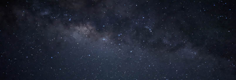
Milky way from Mawsons Hut
19
on to Valentines that mentioned that Whites River Hut was chockers, so we determined that Schlink was the destination for us. It came up soon enough and the deteriorating weather made it a welcome sight. It was empty, so we lit a fire in the stove and settled in to dry sweaty clothes and make chocolate pudding and concoct a better version of Nasi Goring than had come out of a freeze-dry meal packet a couple of nights previous. I'm gonna call that previous one Nasty Boring, it was so tasteless. My new improved version had two packets of soup for flavor, two cups of freeze-dried rice for substance and half a packet of Surprise dried peas for texture and was far superior. Oh, and the last of the garlic flavored olive-oil. The wind howled up a storm that night and I was so glad that we weren't out in the Big Sky Chinook, supposedly four season tent, that I had lugged all the way. It might have taken the wind, but I wasn't at all sure the wind wouldn't have taken it. Some of those gusts shook the hut! I think I'm gonna need a stronger tent. (I bought a Mont Krypton a few days later. We'll see if it is good in the wind ...).
Day 5: Schlink Hilton to Guthega Power Station, 10 km, 5 hrsThe next day dawned grim, but we had a few centimeters of fresh snow, so that was nice. After a bit of kerfuffle finding the track again in the crap visibility, we crossed the bridge
and headed back down Schlink Pass Road for the power station and the car. Passing Whites River Hut, we saw no sign of occupants nor skis outside, so either they'd all packed up their tents and gone home, or onwards over Gungartan Pass, or they'd all been rescued by the snow-cat that we found the tracks of. It wasn't bad skiing, we only had to walk maybe the last three kilometers, but that was enough to make me glad I'd lugged my lightweight Solomon Ultra X Mids along all the way, as they were glorious to walk in compared to ski-boots. I had to stop in the middle of a ford across a creek to test the water-proof Sealskinz socks I was wearing, much to Gordon's consternation, as he was following close behind and didn't have any Sealskinz to test. Oops. The socks worked, BTW. I'd recommend the calf-length ones in the snow for normal boots though they are too thick for tight-fitting ski boots. They are nice and warm, as well as waterproof. (Downside is if they do get wet inside they take forever to dry).
We were happy to find that the car didn't have flat batteries (it had happened before from a carelessly left on boot light or passenger light). We headed off for Gippsland, glad for a chance for non-freeze-dried food, hot showers and a proper coffee or two.
In summary, great trip, not hard, glad of the two sunny days and the firm snow.
I was caught up in mountain pursuits as a teenager, involved with the Shepparton High School Mountaineering Club under the stern eye and rigorous tutelage of Don Moore. That's where I met Gordon. We did numerous hikes and camps in the snow, culminating with a trip to NZ to climb Mt Cook via Zurbriggens Route at the tender age of 16. Between university, marriage, jobs, raising a family and retirement, I managed to stay in touch with Gordon, and we regularly did a hike or ski-tour every year if we could. Over a few summers starting in 2016 we hiked the AAWT together, a few hundred kilometers at a time. Since retirement, my focus has been on trail running, and I recently tried (but failed at the 140 km mark due to broken running poles, broken body and severely dented spirit) to complete a 160 km run in the Grampians. I swore never to do that event again, so naturally, I just signed up for the 2024 event to try again.
<


20 | Bushwalk February 2024