"

McMillans Track
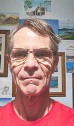
Text and photosTerry Cornall
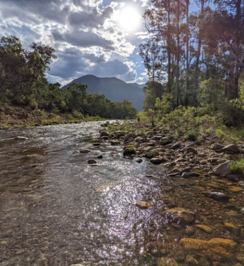
Moroka River
I perpetrated this blog, about a trip in January 2022 when I completed a 13-day hike with Gordon Bedford. We hiked the McMillans Track in Victoria, Australia. It was a bit of a mixed bag, and now I want to share the good, the bad and the ugly of it all with you.

4 | Bushwalk April 2024
The McMillans Track is one that I know my friend Gordon has had his eyes upon for some little while. I personally had never heard of it until he started to mention it occasionally when we were out doing some other adventure. It sounded long and bush-bashy, but one attractive feature was that it was all within Victoria. After almost getting locked out of our home state during the COVID border-closure ructions in Jan 2021, we were keen to avoid a repeat.
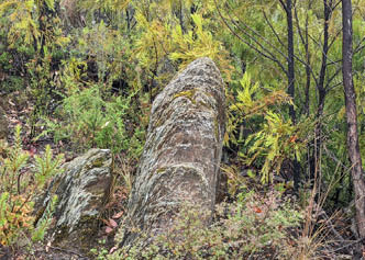
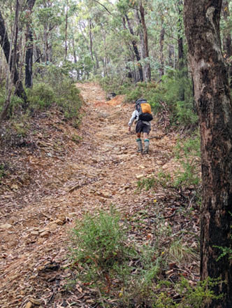
It's 220 km long and travels from near Mt Hotham to Woods Point over many roads, 4x4 tracks, bush tracks, trackless tangles and even some virtual tunnels carved through the living bush. It goes up and over a lot of ridges, contains a lot of nice rivers and flats, has great views, interesting geology and biology.
It was hard on the feet, generally easy to navigate but in places very hard to find a path. Parts of it I loved, parts I hated and parts were plain boring. I'll never ever do it again. Once was sufficient. I might do sections of it again though, armed with a machete perhaps.
Why, why why?
Why what? Why is a duck? Because one of its legs is both the same, of course. Why this blog? Why do a 13-day hike? Why go hiking with Gordon? Why go in summer when it's hot?
Life is full of 'why' questions and I had a bit of time to ponder these during the hike. As for why this blog - well, you can blame a nice man at Eaglevale campsite on the Wonnangatta who, after his wife suggested it, came over to offer us some cold water and have a chat. This guy was full of questions, and one of his first was 'Are you going to blog it?' The question stuck in my mind, and I decided to give it a go. I love writing. A Bachelor's, a Master's and a PhD theses, two
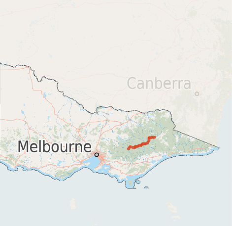
The hike compared to most of the rest of Victoria. Big, isn't it?
"
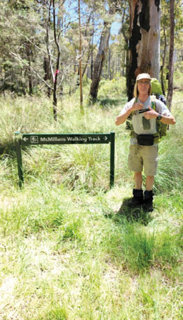
The question stuck in my mind, and I decided to give it a go.


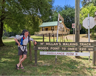
Terry by the walk's sign
5
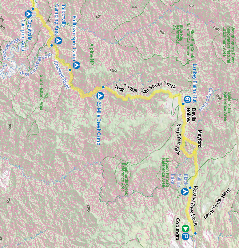
This map is © Bushwalk.com and is created using data © OpenStreetMap contributors

Road, four-wheel drive track, walking track (treed)
Main track, side trip, alternative route
Cliff, major contour line, minor contour line (100 metre interval)
Lake, river, waterfall or creek


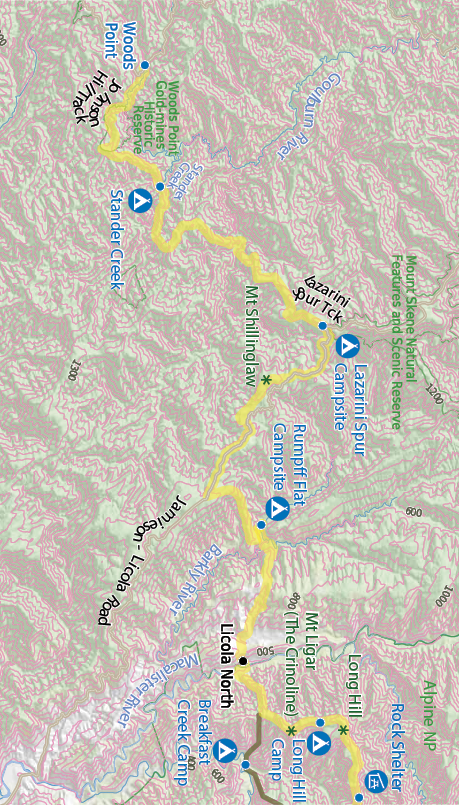
McMillans Track, part 1


0 2 4 6 8 10km


Start of the walk
Hut
Campsite
Toilet
Parking


6 | Bushwalk April 2024
not very successful Kindle sci-fantasy novels (shameless plug: Damsels & Dragons and Dragons' Pyre) and many, many megabytes of technical documentation have not blunted my enthusiasm for getting words and images down and bashed into shape. Besides, it gives me something to do that will help me remember the trip. I have a terrible memory which is one more reason why I write things down.
Why do this hike? Or any hike at all, really. Why not car-camp like all the others we saw on this trip. Well, apart from a few exceptions, like the cold-water guy and his wife, all the car-campers we saw were sitting around their vans drinking or tearing up and down the track or playing in the mud in their 4x4s and that seems like a very boring sort of holiday to me. I like to get out into it and enjoy the scenery and the weather, even if it does turn to crap sometimes. Some of my best memories are about being miserable. Hmm, that doesn't sound like a good comment on my mind-state, does it? Perhaps I should say that triumphing over adversity gives me a smug sort of pleasure. Ok, I'm digging myself into a hole here. Coming across as being all weird. Maybe I am. Anyway, I'm pretty sure that the 4x4-ers never discovered the half of what was out there in the bush. The vistas maybe, fleetingly from a scenic lookout or the midst of a dust cloud, but they didn't see that huge bluetongue lizard unless they ran over him, and maybe not even then. They didn't battle blackberry bush tendrils with a stick wielded like a cavalry sabre, working on the backstroke as if cleaving orcan helms. They didn't have to fight off the face-hugging spiders on the bush tracks. They didn't hunt for thunder eggs whilst wading up a freezing river. Actually that bit was kinda nice, I must be getting soft. They never got to go spider-fishing for a ginormous mouse-spider. They never stumbled across the remains of someone's bush camp in the middle of a trackless wilderness that contained three huge frying pans, a hammer and a strange collection of ointments and vitamin supplements. They didn't have to push on walking even though their feet had been worn down to bleeding stumps. They never struggled through wet bush to climb a fantastically shaped mountain in the mist,
all for nothing because there was no view to be had other than what looked like the inside of a ping-pong ball, now did they? They didn't EARN it. And maybe that sums it up. Deliberately undergoing adversity and triumphing makes all the good things more meaningful and intense because you know you earned them. A healthy dose of masochism helps too, I suspect.
However, there are limits. Too many blackberry brambles, too hot conditions, too steep roads, too heavy pack, too many kilometres per day, too much pain in the feet/back/whatever, too little food, too cold conditions, too grumpy/talkative/careless/thoughtless/selfish companions, all these can ruin a trip. Fortunately, we got the balance more or less right on this one. And that leads me to a very important "why". Why go hiking with Gordon? (Substitute name of hike buddy(s) as appropriate). Because I know him well, know his judgement is to be trusted, especially when it comes to hiking, planning, navigation and path finding. He isn't bossy except when it really counts. Like, no Terry, that overhanging icy cornice is not a good place to be under. He's willing to listen to my suggestions and concerns, and compromise when needed. Plus he laughs, well, grins, at at least some of my jokes. I know of people who refuse to do hikes/bike-rides/camping with strangers. I have some sympathy for that point of view, though it begs the question of how you get started to know someone well enough to accept them. Just imagine getting stuck for weeks with someone you grow to dislike. What a nightmare. What a theme for a movie...
Loggy sticks
Planning and logistics for an almost two-week hike is conceptually simple. Know where you are going, arrange to get there and get back home again at the end, take enough food, gear and information to survive in relative
"
He's willing to listen to my suggestions and concerns, and compromise when needed.
7
comfort and help you not get lost and get you rescued in case of an accident. In practice it's a bit harder. What's the weather going to do? What clothes do I need? Which boots/shoes to take? What food and how much? What tent, sleeping bag, raincoat? Who brings what? What sort of hiking? Dry, wet, open tracks, bush-bashing through blackberries, wading across/up rivers? All of the above? Will I need a machete? Light-sabre? Batteries for devices? Which devices? I got lots! Track notes? Water availability, campsites, resupply? So many questions to ponder. I have a friend whose mantra is "I'd rather be looking at it than for it". My response, when it comes to camping should be "OK, but you gotta carry it". Taking too much stuff seems to be a continuing fault with me, as you'll discover in my musings below or in the gear article in the next edition of the magazine. Perhaps if I laid it all out on the floor before packing and then divided it into 'Stuff I absolutely need to survive', 'luxuries I must have', 'things I might suffer from if I didn't have', ‘luxuries I'd miss', 'things I probably won't need'. Even that approach fails me, as you'll see. The category I fail in most is the 'things I might suffer from if I didn't have'. E.g. extra clothes. Planning for contingencies is a good thing, don't get me wrong, but you can go too far.
Food me, Marge
It helped that Gordon and I had done this sort of thing before (The Australian Alpine Walking Track (AAWT)) plus numerous others over the almost 50 or so years we've known each other. So divvying up the provisioning was fairly simple. He does breakfasts because I can't cook porridge without burning it, and I did dinners because I know how to boil water. We did our own lunches, no cooking involved, just salami and cheese on VitaWeet biscuits for me. Fruity Filled Bars from Aldi appeared to go down well also. Freeze-dried meals from Backcountry Cuisine and Outdoor Gourmet
featured heavily for the dinners, plus some home-designed desserts (Coles Chocolate Mousse made with Amyam dehydrated coconut milk anyone?) to look forward to every other night. And Snickers bars to bribe Gordon into carrying all of the tent.
Soup every night was a must and something we both looked forward to. I like the Continental Soup Sensations brand, especially their various creamy vegetable soups. Yum. Available from Coles and probably other outlets as well.
Chapman's track notes
McMillans Walking Track is an excellent resource giving good detailed track notes. One thing we noticed though was that we usually took a bit longer to complete a section than the notes suggested. Maybe we took longer breaks, or I was just plain slow. Also, anytime it mentioned 'track may become vague or choked with blackberries' we knew it was going to be a monster. 'Steep short ascent' should be read as 'brutal' and 'challenging' means exactly what it says. 'Interesting' needed to be treated with caution.
Going forth. Enough prep, let's do it!
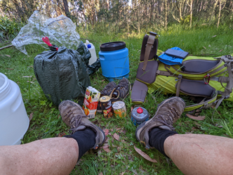
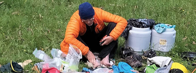
Hike prep finished with a drive from my home in Lysterfield in Melbourne, down to Gordon's place in Warragul, to do a drive up past Licola to place resupply barrels at about halfway. Food, water, gas, rechargers, fresh undies, drop-day celebratory items like orange juice and pineapple pieces and chunky soup-inna-can, that sort of thing. Duly waypointed on various GPS devices we camouflaged the drop barrels in garbage bags and hid them as best we could, and then abandoned them to the weather for the next week. I left wondering how the cheese would fare in the heat... it went fine, just a tiny spot of mould where it had been cut. Next time I’ll get a smaller block and won’t open it.
A few days later, along with my wife Jennifer, who was going to drive my car home, I drove down to Gordon's place again. Then along with his wife Heather, he and I drove up to Cobungra, near Omeo, to start the hike. Clearly, an important part of the undertaking was keeping in sweet with our spouses who did the car shuffling for us. Thanks, ladies.
"
Planning for contingencies is a good thing, don't get me wrong, but you can go too far.
8 | Bushwalk April 2024
Black Sallee Lake
Whoa oh Black Sallee, wham da lam
Day 1: Cobungra to Black Sallee Lake, 8 km, 2 hrs
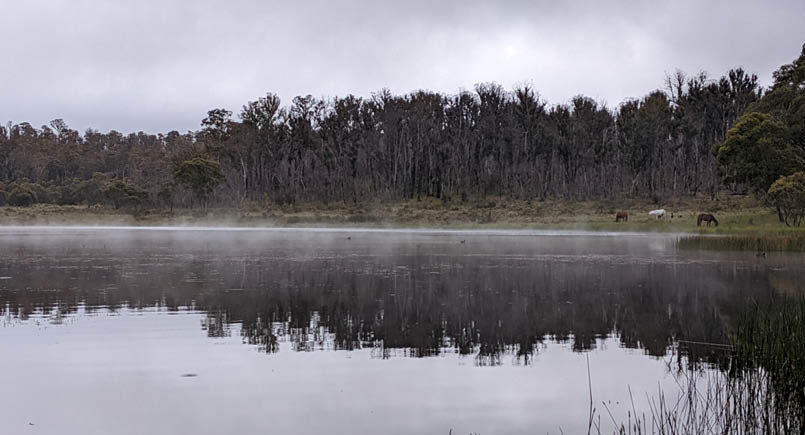
It was a short, pleasant walk from the Cobungra turn-off from the Omeo to Hotham road to the first campsite, along Victoria River Track. The lake was dark and gently misted when we got there, as the air had turned cold. We saw what we initially took for brumbies on the other side of the water, but it turned out they were riding horses, and we saw and heard people once in a while.
Getting water from the lake was a bit dicey as the edges were soft and it looked a little manky anyway. So I found the inlet stream which was flowing weakly and followed it upwards a bit to get to somewhere that looked better. I had to throw away the first water I got because I also found a dead deer leg just upstream from it, but then even further upstream I found better-flowing water anyway. I tried the Lifestraw filter bottle I'd brought to clean it up a bit, but it was way too slow. I got about 2 litres through it before my hands started cramping from squeezing it and deciding that this was silly, and just doped the
water up on iodine and/or chlorine pills. The filter bottle got put away and abandoned in a drop-barrel at halfway. I doubt I'll ever use it again, except maybe as a personal drink bottle, which is probably what it was designed for, to be fair.
Road, him go up, him go down again
Day 2: Black Sallee to Lankey Plains Hut via King Spur Track, 17 km, 8 hrs
I've decided that a lot of the roads in this part of the bush must have been built by a primitive race that hadn't invented contouring. Either that, or some guy in a bulldozer had been instructed to minimise distance, tree-felling and rock cutting. We called him George, but learned later from the cold-water guy that his actual name was Aubrey. Many of the roads we encountered took the shortest path from A to B, and if that resulted in a 25% or more grade, well, too bad. Greater than 25% means it rises more than 1 m up for every 4m forward, which doesn't sound like much, but you try walking up it for a few kilometres in the heat! It's not as steep as a staircase, but it feels like one without treads! A bit of rain then turns it into a rockface in some
9
cases. If anyone knows why it was done this way, we'd love to know. It can't have been for logging trucks, it’s too steep. Fire access, maybe? Kept open now for tourism?
In this case, on the track we came down on day 2 after a nice hike from Black Sallee, the road had been closed, reportedly because it was too steep and people kept dying on it when their cars rolled. It had revegetated somewhat, but it was a doozy, and I was too busy trying to stay upright to take a photo of it. To keep people in cars off, they felled logs and dug berms across it and generally turned it into something even 4x4 drivers would hesitate at and say, 'Whoa, now, let's have a think about this!', which takes some doing. It wasn't fun to walk down either. Here's what Parks had to say about it (found here: Mayford Spur Track Via Dargo High Plains | 4x4Earth):
"The track from the Dargo River up to the Dinner Plain Track has now been shut for many decades and will not be re-opened. During its time open it posed many challenges for managers and due to grade was a safety risk. We utilised the road as a fire containment line during the 2003 fires and even then, it was risky for staff and contractors on machines."
You can get an idea what it was like from pictures in this link Mayford - Mayfors Spur Track CLOSED (4x4earth.com).
After a rest at the bottom of the closed Mayford Spur Track, we eschewed the usual path going on to Mayford Flats, and then up Treasure Spur as we were worried that the spur would be choked with regrowth. We chose to go up King Spur Track instead, which was obviously open because the 4x4s were roaring down from it. A few river crossings and a long hike up the road got us to Long Spur Track and then a flattish path alongside Devils Hollow. We were greeted by a number of the many car-campers ensconced there, one guy waving beer in the air. Tempting, but no. We wanted to finish the day. This eventually led us to Lankey Plain Hut, which was in the middle of a muddy moat, dug by thoughtless drivers and currently occupied, so we pushed past it and up onto a tussocky field for the night. After arguing with the ants we finally got the tent up. I tried some astrophotography on my Pixel
5 after dinner to see if I could get the dead trees starkly outlined against the Milky Way. Useless camera app interface defeated me, not for the last time.
Timber!
Day 3: Lankey Plain Hut to 25 Mile Creek via White Timber Spur South Track, 20 km, 9 hrs
Down Dargo High Plains Road a little and then off into tussocky plains to find a boundary fence which we followed until it got us to White Timber Spur North Track. The tussocks were a complete pain and made for slow going. The road and fence were such that we actually went some way along the fence more than we needed to, before doing a hairpin turn on the road and coming back. We were looking for the turnoff, but it was bit too low down for us to see.
Then down that track to Ritchie Road and over it to White Timber Spur South Track. It was a hot day and my feet were killing me already. I was really glad to see the end
We camped on this tussocky paddock, not far from the nice water
10 | Bushwalk April 2024
Nice work

of the road but then we had to descend a really steep single-track, which zig-zagged down through the bush to 25 Mile Creek. Even though some of the zags were pretty precipitous, it would have been a nice section, except it was at the dirty end of the day. Then across the creek to a tiny campsite, just barely big enough for our tent. Baths in the creek followed to wash the trail dust away. No nudie photos. I do have some sense of good taste.
Here be dragons
This big water dragon I didn't even have to sneak up on. After making soup, I sat down exhausted on a nice rock to rest my feet, and there he was, only a coupla metres away. It even stayed still long enough for me to get the camera out and snap a few shots. That's star quality that is.
Blackberries, benching and Bulltown Spur
Day 4: 25 Mile Creek to Bulltown Spur, 13 km, 8 hrs
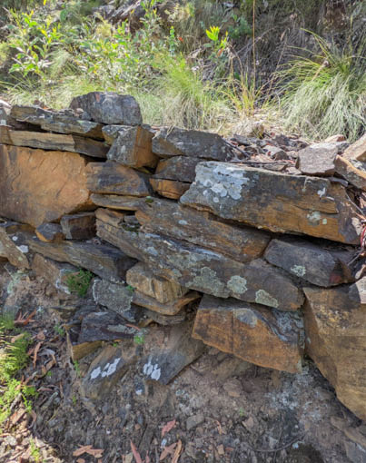
Parts of the track on the next day's first section had nice stonework holding it up and making for a good benched track. We did have to carve our way up out of the campsite through blackberry bushes to get going, but I managed to find a jewel in the brambles, a small raspberry with some tasty fruit on it. Yum. After all the bush-bashing to get to it that morning, this clear part of the track was delightful walking. This photo shows where it had probably been recently restored.
Walk a crooked mile
On to Thirty Mile Creek and then to Crooked River, hiking on reasonably good tracks high above the river. No real crossings until we got to Bulltown Spur that evening. When we got to where we were planning to stay after fording the creek, there were a few blokes sitting at their cars and vans, playing gin rummy or something, and I bellied up to them and asked brusquely, "Are you blokes going to be partying noisily all night, or what?" They answered "No, certainly not" or similar, with affronted mien, to which I responded, "Bugger that then, I'm not staying here". After ensuing hilarity (wry grins, 'cos they were laconic Aussie blokes), one of them pointed out a nice grassy campsite a few hundred metres down the track. It was one of the better spots we camped at. Nice starscape, too.
He was pretty chill
11
Astrophotography
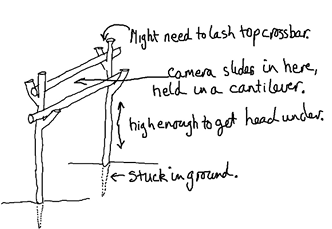
I love the astrophotography feature on my Pixel 5 phone's camera app. Well, let me rephrase that. I love the results when I can get them, and I hate the user interface. Here's how I would describe the process: Open the camera app and select 'night vision'. Keep the camera very still in a dark place and magically it will decide to go into astro mode, which takes multiple images and 'stacks' them and does other automatic editing tweaks. Dare to move it whilst trying to press the 'take the bloody picture' button, and it'll drop out of astro mode back to single-shot and admonish you for not keeping still. Now imagine doing all that whilst the camera is pointing straight up. That's where the stars are, right? So, the screen with the button and the icon indicating astro mode is pointing straight down, which means that to see it, you have to have a tallish tripod (nope, left it behind, too heavy), or you've managed to balance the expensive phone/camera overhanging enough from a rock or log with enough room to get your head under it to see what's going on. Or you manage to use the timer feature and hope that it goes into astro mode and doesn't just take a single night-vision shot. All the while you are standing on your head in the dark, the mossies are sucking you dry, and you are freezing to death. Slight hyperbole there, it was actually fairly warm. The mossies were real though... Oh, and if you do manage to be lucky enough to start the photo in astro mode, it does it all silently, so you don't really know it has worked until you wait for three minutes and then pick it up and have a look. I ruined a couple of tries by picking it up early. Of course, it does tell you what's going on, but it's all on the screen you really can't see because the camera is on its back on a log!
I spent a good part of my walking time during that hike composing a scathing letter to the idiotic developers of that app asking why they couldn't just have a fixed astro mode instead of one that turns itself on and off! Also designing a makeshift 'tripod'. After I got home, I discovered that I could have pressed the volume button to take the photo, there's a setting in the camera app... That would have helped a bit. Anyway, here's my 'tripod' design. Yeah, yeah, only has two legs... You know what I mean, stop being pedantic. That's my job.
I have since learned that the best way to use the Astrophotography mode on the Pixel, if you don't have a tripod, is to face the camera down on the grass, pointing at the ground so you can see the screen. In the dark and not being jostled, it goes into astro mode and then you can press the 'go' button, flip the camera the right way up again and point it at the stars. It seems to work well. Maybe even use the shutter delay feature, though it doesn't seem to care.
The photo on the next page was taken at our campsite near the Bulltown Spur on Crooked River at the end of day 4. I managed to 'paint' the trees with my torch just at the right time to get them lit up in the photo. This was a matter of luck. It doesn't spend all its time acquiring, so a brief flash might get missed. There is some blurring on the leaves, but who cares. It's a marvellously starlit image from such relatively unsuitable camera hardware (small lens, small sensor, low exposure time) without needing a tracking mount, thanks to the 'stacking' methodology and other tweaks. Google 'astrophotography on Pixel' to find out more. Pity about the useless user interface, but now that I know better, I'll use my 'facedown' trick, or I'll take a superlight tripod next time.- Or a phone holder I can clamp to a hiking pole, a tree or something. Maybe one with a Bluetooth shutter trigger. K Mart has one for $25 with said accessory. I got one a few weeks later and it does the job. It is light, has a good smartphone adapter that works with my thickly armoured Pixel, and the Bluetooth trigger just works. Nice.
12 | Bushwalk April 2024
Why did the hiker cross the river?
Day 5: Bulltown Spur to
Eaglevale Camping Area, 17 km, 8 hrs
In the section down the Crooked River on day 5 there were 23 fords to cross. It was a hot day, and the rush of the cool but not cold water wasn't too challenging most of the time. It was fun. I did have to watch out for 4x4s coming thundering over the banks and running us over though. Gordon was halfway across when one pair of cars came through, but they slowed down and didn't swamp him. At another crossing, I had to hold onto a lively young pitbull puppy that had come waggling across the track to greet us, just as a convoy came recklessly splashing across the ford. Doggie wanted to run back to his boss, right under the wheels of the cruisers, didn't he? I barely managed to hold him and didn't get bitten even once.
I could usually tell how high the water was by sending Gordon first and checking the pitch of his voice. When it reached soprano, I knew it was too deep.
A plum spot
Talbotville made a nice lunch spot on day 5 after all the river crossings in the morning. There was a big open parkland with lots of people having a good time. We found a delightfully shady place in an old orchard that had ripe plums to eat, but unfortunately unripe pears and figs for us to only contemplate. The plums were delicious. I've often come across fruit trees at old settlements and this was the first time they've been ripe. If only Bloody Baron Von Mueller (Introduced plants | Ergo (slv.vic.gov.au)) had thought to send out packets of apple seeds instead of blackberries to be sown in the wild, things might have been much better.
Oh, the horror!
After our restful lunch, we metaphorically girded our loins (how exactly do you do that?), and then we had to toddle along Brewery Creek Road for a bit to then divert off onto a short section of the Bicentennial Trail that coincides with McMillans Track. We bashed through insane blackberry and bush regrowth down to the Wongungarra River to get from Talbotville to Station Track. Yuck!
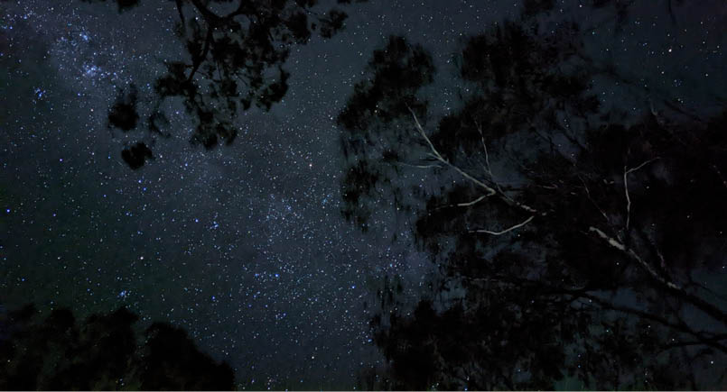
Starry, starry night...

13
Then there came the horror of Station Track, which was another of those 'straight up to the top' roads, but with added spice of a very hot day and very little shade. We must have looked in dire straits as we struggled up it from tree shadow to shadow. A convoy of 4x4s came down and the lead one stopped to offer us some water. When finally we made it up and recovered, it was down from the Cynthia Range Track almost to the Wonnangatta River. We walked along a private fence through horrible long grass to the suspension bridge, and then into a nice open flat, accompanied by 'doof doof' music from the car-campers. This is when the 'cold-water guy' that inspired me to perpetrate this blog came over and had a chat.
I tried again to do some astrophotography that night, but the useless interface defeated me. It would only have been boring stars without any landscape anyway. Pah!
Moroka River, hunting thundereggs
Day 6: Eaglevale Camping Area to Carey Creek
13 km, 7 hrs
Day 6 found us going up the Moroka Junction Track (road) until it abruptly stopped being a road and turned into a walking track. We
rested there for lunch and were amused by the 4x4 drivers that roared in, had a look and then roared out again.
After lunch we tried to walk alongside the Moroka River, but failed to have a lot of fun. The track was indistinct and there was plenty of bush to push through. We found it a lot easier to go down to the river and either wade up it or better, walk on the pebble shingles. This is where I first realised that gaiters and rushing currents were not a good combo.
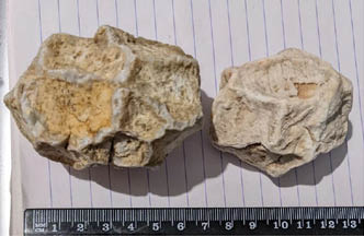
Rollin' stones
I knew from notations on the maps that thundereggs (geodes) could be found around here and I kept my eyes open as we waded up river, possibly accounting for how slowly we made progress. We didn’t find any conventional ones, but did find some unusual opaque, white, egg-shaped pebbles, possibly river-tumbled amorphous quartz or quartzite. They had what looked like a web of harder, probably quartz veins embedded in them and slightly raised on the surface in a polygonal pattern.
Using 'lens' image search on the phone, the best hits I got were for geodes, but none of the returned hits had that polygonal 'web',

Rocks in Moroka River
14 | Bushwalk April 2024

This map is © Bushwalk.com and is created using data © OpenStreetMap contributors
Road, four-wheel drive track, walking track (treed)
Main track, side trip, alternative route
Cliff, major contour line, minor contour line (100 metre interval)
Lake, river, waterfall or creek
McMillans Track, part 2
0 2 4 6 8 10km

Wading up the Moroka River
Start of the walk
Hut
Shelter
Campsite
Toilet
Parking

15
so I am still puzzled. My guess is that they were formed by hot fluids depositing the veins within a slightly softer matrix of quartz or quartzite. Then tumbled in rivers for millions of years.
Shelob and her spawn (caution, upcoming arachnid images)
At the campsite for day 6 at the confluence of Carey Creek and Moroka River, I sat down with a tree at my back. I had a much needed coffee and happened to glance down and find a silken tube about 4 cm across, sticking up dangerously near my groinal area. Rather than mindlessly panic (which I really should have, but I needed that coffee. It'd been a hard day), I finished my coffee, and then, after wisely retreating a bit, I tickled the edge of the nest with a stalk of grass to see who was home. The big maybe-female-mouse-spider critter that came thundering out covered in spiderlings, I called her Shelob. After teasing her out of her nest I relented and left her alone. Poor thing, all those kids constantly on her back and with a wandering spouse, she didn't need people knocking on the front door all the time.
Here's the video of Shelob attacking my grass. I'd put my hand down there for scale, but no, I'm not going to do that. Don't play it if spiders scare you. Oh, too late... Also, the video is part real-time, part slow-mo, just for kicks. You can tell which is which when the birdsong goes all 'bwahh, bwah...'
Drop barrel day!
Day 7: Carey Creek to Volkswagen
16 km, 8 hrs
Day 7 was drop barrel day and we really had to earn it. We started well with a wander up the Moroka River, but then we decided to bypass Playboy Creek and the dubious 'interesting' bit up a possibly poorly defined D4 Track. We climbed up the Moroka River Track to meet Doolans Plains Road and then a bit back down Moroka Road to Volkswagen instead. It's named after a long-removed junk vehicle. That climb was a nightmare for my poor feet, but we got it done and then we could celebrate with some orange juice and some lovely chunky soup in addition to the usual freeze-dried Lamb Roast with Vegetables (or whatever), followed by juicy pineapple pieces. And I changed my boots. I love drop barrel day!
I shall call them dragon-eggs until I get a better classification

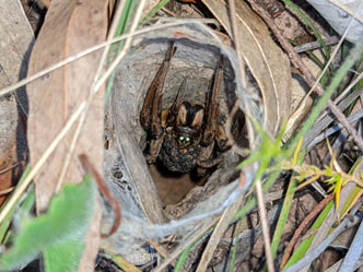
Hey Mama. What big fangs you have, and those evil glowing eyes!
Mmmmm, drop-day goodies
16 | Bushwalk April 2024
Remember the log?Day 8: Volkswagen to Shaw Creek
18 km, 8 hrs
From Volkswagen, we marched up through Arbuckle Junction the next day and then over Mt Arbuckle, had lunch at Kelly Hut. It was unattractive on the inside, so we sat on a nearby log, and this morning was some of the nicest walking we did. Maybe the drop-day celebratory feast helped. Gordon reminded me that we'd been here before when we went skiing on Mt Reynard a few years back. I remembered the log.
Then on toward Shaw Creek. We had a chat on the road with another 4x4 driver who expressed some interest in the McMillans Track, despite his little girl urging him to "let's go Daddy, stop talking to those weird men". Then into the campsite, where we found a few car-campers sitting around and one of them trying to catch fish. We camped a bit away from them on a tussocky hill and hoped that they didn't decide to shoot at the deer that was bugling nearby in the middle of the night.
Petticoat junction
Day 9: Shaw Creek to Long Hill, 14 km, 7 hrs
We decided to 'skirt' the part of the McMillans Track that went via Mt Tamboritha and Breakfast Creek in favour of going around via Long Hill and Mt Ligar (The Crinoline). Gordon
didn't like the Breakfast Creek route (long and boring) the last time he did it, and besides, this gave us a chance to summit on Ligar and take in the views. Hah!
On the way, we stopped for lunch at the Rock Shelter. A nice spot with good shade on a hot day. Actually, it was almost cold, but that was a welcome relief.
We were lucky to get this vista of Mt Ligar (The Crinoline) on day 8 from Long Hill, because the next day, when we climbed it, it was all misty and we could see nothing. D'you reckon it looks like a lady's petticoat? Well, actually, see some of the images in Death by Crinoline? - Molly Brown House Museum.
When I went back to the area a couple of weeks later to retrieve the drop barrels, I climbed the Crinoline from the other side, starting at Breakfast Creek. I wrote it up separately, so if you are interested in what the view should have looked like, look for it here: terrycornall.wixsite.com/website/post/petticoats-in-a-twist-on-the-crinoline.
After Rock Shelter we had an issue with the path going invisible, and eventually we just followed the rim around to the campsite. Getting water wasn't fun because although there was a blazed tree showing where to go to get it, the path faded to nothing after a
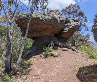
Rock Shelter - a welcome shade, but that block there looks a little loose, d'you think?

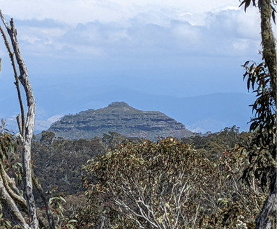
Does this look like a ladies petticoat to you?
17
This map is © Bushwalk.com and is created using data © OpenStreetMap contributors
Road, four-wheel drive track, walking track (treed)
Main track, side trip, alternative route
Cliff, major contour line, minor contour line (100 metre interval)
Lake, river, waterfall or creek
McMillans Track, part 3
0 2 4 6 8 10km
Terry wondering which excess baggage to leave in the drop barrels
Start of the walk
Hut
Shelter
Campsite
Toilet
Parking
18 | Bushwalk April 2024
few hundred metres, and I just had to keep heading east, pushing through the bush until I got wet feet to find it. Nice water though. Cool on the toesies.
Misty Mountains
Day 10: Long Hill to Rumpffs Flat Campsite,
17 km, 8 hrs
Day 10, and from the camp on Long Hill we went up Mt Ligar in the mist after a bit of a bash through wet bush. We had the morning bath at the same time. Getting to the summit wasn't hard, even though we couldn't see much. Once we got across the narrow ridge that joins Long Hill to Ligar, the bands of rocks that give it the Crinoline monicker make nice terraces, with a bit of a scramble to get up between them in a number of places. The difficult bit was working out what path to take to get from band of rock to band of rock. Gordon did a great job of pathfinding and we didn't waste a lot of time searching for these transitions. In places, the path goes up slopes of gravelly rock that slips under your feet, and some short climbs are required. It's not terribly exposed, or shouldn't be if you are taking a good path. There are good steps and handholds, and occasionally making use of some handy vegetable handholds helped.
There's a nice copse of trees on the summit of Ligar that would make a reasonable campsite if the winds weren't too strong. From there,
following a fairly well-formed path along the ridge down the southwest side gets you to a junction with McMillans Track again. This path is nicely zig-zagged and not crazy steep anywhere. Another little rock down-climb is needed, but it's easy. Do be careful though. I make light of the difficulty, but in a number of places on Ligar, a slip would result in a painful and possibly dangerous tumble. Just take it thoughtfully as you go.
Then down to the Macalister River, and after a pause under the porch of a farmer's caravan/hunting-hut/retreat overlooking the river, we went up the long dull, soggy Glencairn Road to Middle Ridge Road and then to Rumpfffffs, Flat, or however you stop spelling it. A couple of 4x4 drivers asked us if we were OK on the way past but didn't offer us a lift. We would probably have said 'no thanks' anyway,—at least the first time.
A maze of twisty little passages, all alike
Day 11: Rumpffs Flat Campsite to Lazarini Spur via Mt Shillinglaw, 20 km, 9 hrs
The next morning we endured a long, steep climb out of Rumpffs Flat along McMillan Spur Track to get to the Jamieson-Licola Road, and then we were almost back on familiar territory for me, as the AAWT intersects McMillans Track near here. I still have post-traumatic flashbacks about hauling our drop-day barrels and water over the Rumpff Saddle on that particular trip. (Bad planning to leave drop barrels too far from camp, and the Barkly River Jeep Track there is a perfect example of why you don't make roads so steep that they erode away to rockfaces. Besides, it turns out that there is a perfectly good drivable Barkly River Logging Road that could have gotten us all the way to the camp to leave barrels there, if only we had known. Anyway, on this trip we didn't go so far up the Jamesion-Licola Road, turning off to go to Mt Shillinglaw and then camp at Lazarini Spur instead.)
For some reason I don't have photos of them, but on this day, we traversed bush tracks like the imaginatively named No 18 Track that is maintained apparently by driving down it in a golf-buggy sized vehicle with whirling blades all around it. They were like green tunnels cut through the living bush, and apart from some

Hmm, the path is around here somewhere
19
fallen logs and sapling stumps to liven things up, they were easy walking. We did get so engrossed in whacking blackberries on one section that we missed a turn-off, but that only cost us a few hundred metres and some embarrassment.
I did get yet another fine photo of my favourite stinkhorn, Aseroe rubra somewhere in that section, too.
We got water before the camp at Lazarini Spur by going down a small track that went past a couple of caravans, apparently lodgings
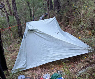
for weed-spraying contractors. I hope that they were there to get the damn blackberries. There was good water there, but also a LOT of leeches, and we were lucky to get away without getting sucked dry. That evening, when choosing a tent site, we were repelled from the best choice by an ants' nest. Gordon found an alternative, saying 'this looks ok, a bit soggy, probably why there aren't any ants here'. It rained that night and guess what happened... Yup, we discovered whether the tent could float. Fortunately, it could.
Welcome to Tombstone, population you
Day 12: Lazarini Spur to Stander Creek,
18 km, 9 hrs
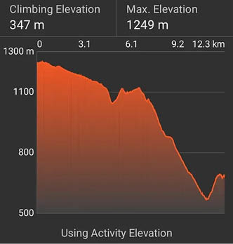
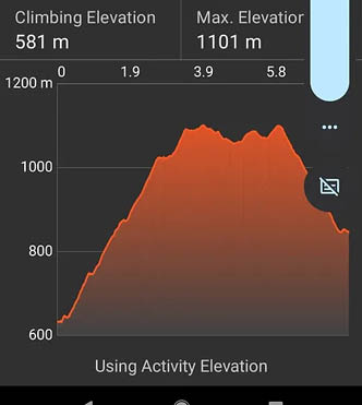
From Lazarini Spur we went down to Black River and up again the next day. I vaguely remember some nasty 'short steep' bits and a bit of scrambling, but don't recall it being too horrible. I must have blanked it out, because Gordon reminded me again about the short, overgrown but steep bit out of the Black River. Look at these two consecutive track elevation profiles. What do you think? Nasty? Well,
Shouldn't we have reached that turn off by now?
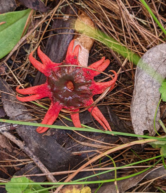
Stinkhorn
20 | Bushwalk April 2024
almost every day looked a bit like this, so no wonder it has all blurred in my memory. Toss in blackberries and regrowth, and it becomes the stuff of PTSD.
Oh, and there were leeches waiting for us at the bottom, around Black River. I unknowingly picked one up inside my gaiters despite
vigilance and didn't find it until later after we'd climbed all the way out. It didn't survive the experience.
After the brutal scramble out of Black River and dealing with that impertinent bloodsucking hitch-hiker, we were sitting under some Cherry Ballart (Exocarpos cupressiformis) trees, all of which were unfortunately bare of fruit. Except for one that improbably had just two of its tiny little red inside-out fruity goodies that caught my eye. They were tasty, but that was all there was. I didn’t share this slim bounty, which earned me a glare from Gordon.
On another cheerful note, I took this photo on day 12 somewhere between Lazarini Spur and Stander Creek where all these tombstones were poking up out of the ground. Spooky.
Although they look it, these bits of rounded sticky-uppy rock are not man-made, but rather something like a metamorphic mica-rich schist that has been tilted up and weathered. There was a whole graveyard of them. I could make a pun about a pile of old schist, but that wouldn't be gneiss....
Then we came across this old ore crusher just before crossing the freezing Stander Creek at the end of the day's walking.
However, this was one campsite distinctly over-endowed with verticality and somewhat lacking in horizontality. This was night 12
Let's go down to the river
Going up!
Here lies Fred. Climbed this hill and now he's dead
21
at Stander Creek. Hah, standing room only creek… The only spot that looked at all possible for the tent was a narrow terrace, a relic of gold mining activity. We looked up and down the track for alternatives, even going to the point of walking further up the steep track to see if it topped out onto something usable. Nope. So back we went to this site and got paleolithic on its grass. I.e. we dug it up and extended it, using flat pieces of rock as shovels, some flakes of slate that happened to be handy. After half an hour's grunt work we had a platform that might do, but it meant one side door was unusable and that the tent roof on that side was a bit wonky, but we decided to leave it at that. It was at least level on the floor, kinda. Well not really, I had to wodge clothes and stuff under my sleeping
mat to stop myself from pushing Gordon out his side of the tent. It rained that night and a big pool of water gathered in the tent fly. We were lucky though that it didn't rain too much and we didn't get inundated.
Oh, you take the high road
Day 13: Last day! Stander Creek to Woods Point, 10 km, 4 hrs
The last leg of our trip on day 13 was up the monstrous slope of the Abbott Creek Track out of Stander Creek and then along a flattish bit until we got to Johnson Hill.
Then along the Johnson Hill Track and then the Goulburn River into Woods Point. At one place we chose to take the road above the creek. Looking down to the valley flats showed another road that crossed the river a few times. It looked quite attractive and we wondered if it might have been better.
Only slightly wonky...
Yep, I was so impressed with this bit that I walked up and down it twice
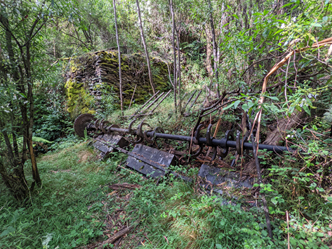
Leichardt Gold Battery ore crusher at Stander's Creek. How on earth did they get it in? The tracks are really steep.
22 | Bushwalk April 2024

Terry was caught up in mountain pursuits as a teenager, involved with the Shepparton High School Mountaineering Club under the stern eye and rigorous tutelage of Don Moore. That's where he met Gordon. They did numerous hikes and camps in the snow, culminating with a trip to NZ to climb Mt Cook via Zurbriggens Route at the tender age of 16. Between university, marriage, jobs, raising a family and retirement, he managed to stay in touch with Gordon, and they regularly did a hike or ski-tour every year if they could. Over a few summers starting in 2016 they hiked the AAWT together, a few hundred kilometers at a time. Since retirement, his focus has been on trail running, and he recently tried (but failed at the 140 km mark due to broken running poles, broken body and severely dented spirit) to complete a 160 km run in the Grampians. He swore never to do that event again, so naturally, he just signed up for the 2024 event to try again.
<

At this point, at an old reconstructed miner's hut just before Comet Flat outside of Woods Point, we read Chapman's notes and got quite confused by them. Eventually we worked out what he was trying to say, though some of his comments didn't make sense to us at the time. Looking back at the notes now, they seem perfectly straightforward. We must have been brain-fogged by the thought of almost being finished... Nonetheless, we took his advice about keeping to the right on the road climbing above the river. It merely meant that we could follow a road above the Goulburn River and keep our feet dry. Going the low route meant a few more creek crossings, which wouldn't have been terrible.
I'm not a celebrity, but get me out of here anyway
Once the hike was done, we needed a retrieval. Gordon's son James did us the favour of coming up to Woods Point to get us, and then regaled us with stories of being a ski bum in Japan. So jealous.
And that's it, apart from going back to retrieve the drop barrels one day real soon before everything in them goes mouldy. I'll wait for some good weather though, and summit Ligar again, and see if I can get some good photos this time.
Like I said above, I'm glad I did it. I had fun on some bits, hated others and wouldn't do it again in its entirety for a great big clock. Life's too short. Now, if you'll excuse me, I have a nice little 28 km trail run down on the Mornington Peninsula to prepare for. Bye for now. Terry.
The original article can be found on Terry's blog.
Hmm, ambulance eh? Maybe... And I have to remember to get more photos of me on these trips. Can't let Gordon hog all the limelight.
23