High Plains Kosciuszko Trip
Text and photosSonya Muhlsimmer
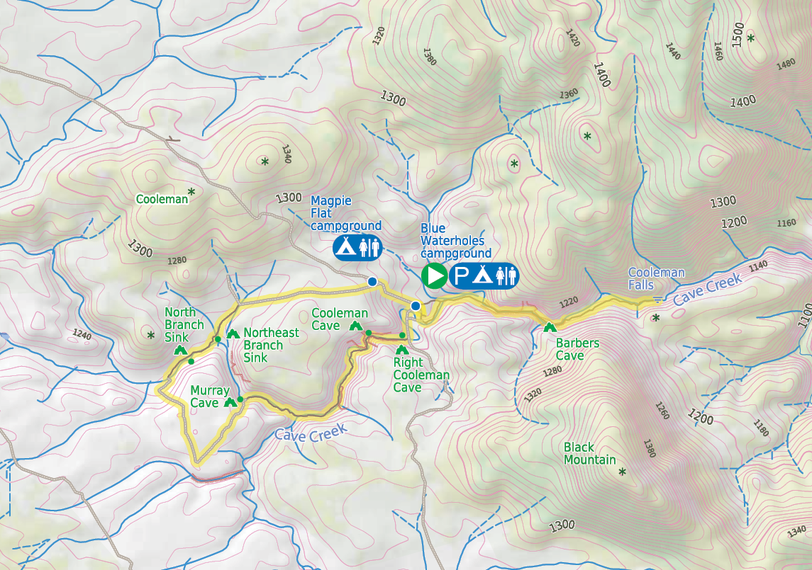
Blue Waterholes
I had the absolute pleasure of spending a magical weekend at the Blue Waterholes with a few good folk recently. It was my commitment as a leader of the Upper Blue Mountains Bushwalking Club to lead a group in Kosciuszko National Park on an annual basis. I take a bunch of fearless people somewhere remote and show them some of my favourite areas in the park.


38 | Bushwalk April 2024
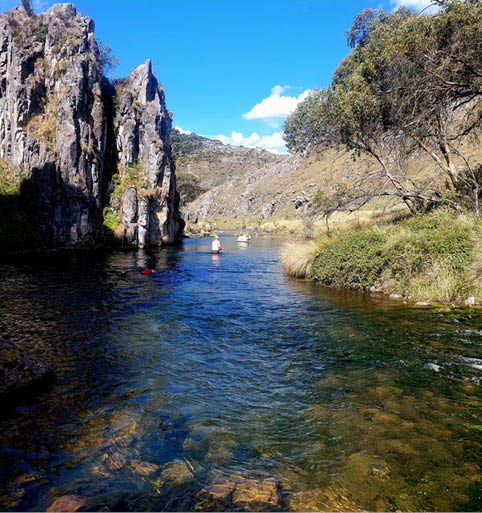
Clarkes Gorge
The High Plains are a little less visited in comparison to the Main Range circuit. It is a little further away and more remote, along a very long dirt road and down a steep and somewhat rough track where a 4WD is recommended, as if you get some wet weather a 2WD may not be able to make it. There, at the end of the road, you will come to some pretty spectacular gorges.
I arrived at the Blue Waterholes in the early afternoon, not long after a couple of people in my group turned up and slowly, one by one, the rest of the group arrived for the night. I was expecting one more person, but she was coming in the morning. We all pitched our tents and some organised their camper trailer, got the fire going, cooked dinner, then we all enjoyed the fire until it was time for bed. It was good getting there on a Thursday, as not many people were around.
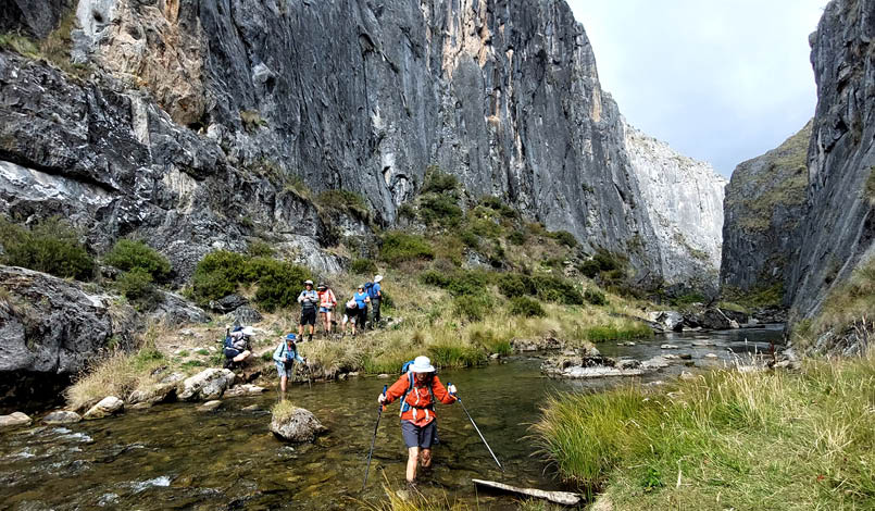
The last group member turned up around 10am the next morning and we were off to explore Clarkes Gorge. The walk starts at the
campground and follows Cave Creek, walking along the towering and narrow limestone cliffs till you reach Cooleman Falls. Clarkes Gorge was cut by Cave Creek and apparently the rock features and many caves along the way were formed more than 400 million years ago. So, as you can imagine, the walk down the gorge has many creek crossings. I lost count of the amount of time we crossed to the other side, only for the ground to run out due to the cliffs and to cross back over. It was wet feet all day. Once we reached the waterfall, it was time for a break to take it all in. I went on ahead to see if we could go a bit further, but I could not find an easy way down so I decided not to continue. For the more adventurous hikers, you can continue this walk to the junction of Cave Creek and the Goodradigbee River, but we just stopped at the waterfalls. The 15-metre waterfalls were impressive enough. After a break we scrambled back up the side of the falls, crossed the river and explored Fish River Caves, a small but interesting cave, then we continued back to camp.
39
After reaching camp I spoke to some fellow campers and they gave me a hint that at the top of the hill was where we could see some wild brumbies. They said they saw a few hundred at least. A few of us decided to explore while others stayed back for a rest and a bit of a swim. From the campground, a fire trail was followed uphill for just under 3 kilometres. There the bush disappeared and the high plains opened up. A couple of people in my group went searching for the brumbies on a side track, through some bush, and they were in luck. The rest of us missed out. Once the brumbies noticed they were being watched, off they went in the other direction.
Once back at camp, it was time for a swim in the icy cold waters of the Blue Waterholes, aptly named as the water has a beautiful blue hue to it. This blue colour is due to its high calcium carbonate content from the limestone. The water is always very cold here as Cave Creek runs underground up to the waterholes. After a bit of a dip it was back to camp to warm up by the fire and settle in for the night.
The next day was down Nichols Gorge, where the scenery was completely different. The walk follows Cave Creek, but the creek is underground, so the track follows a dry creek bed. As you start the walk, Cooleman Caves were reached, so on with the head torch and in we went. The cave can be explored for about 50 metres or so, and it was worth doing. The cave is still active, so with a little bit of light, the calcite walls sparkle with thousands of little water droplets. It was stunning.
After exploring the cave, we followed the dry creek bed down along the gorge and eventually reached Murray Cave. This cave is deeper, darker and fairly narrow and I must say a little more spectacular. Again we put on the head torches and went in for just under 200 metres. You can walk all the way till you reach a siphon blocking the rest of the cave system. This is a good example of the underground creek systems in the area. Our group didn’t quite get to the end as we were all very busy looking for fossils along the walls and floors and admiring the

Cooleman Falls


40 | Bushwalk April 2024


Bushwalk.com notes and maps for Clarke Gorge Walking Track on webpage, GPX and PDFBushwalk.com notes and maps for Nichols Gorge Walking Track on webpage, GPX and PDF
This map is © Bushwalk.com and is created using data © OpenStreetMapcontributors
Road, four-wheel drive track, walking track (treed)
Main track, side trip, alternative route
Cliff, major contour line, minor contour line (10 metre interval)
Lake, river, waterfall or creek


High Plains walks


0 0.5 1 1.5 km


Start of the walk
Campsite
Toilet


41
sparkling water droplets on the thousands of stalagmites, stalactites, flowstones and columns. As a small kid I learnt how to remember the difference between stalagmites and stalactites. A stalagmite, just might grow to the top whereas a stalactite, it has to hold on tight. Quite a nifty way to remember don’t you think.
From here it was out of the cave and climb a small hill to the open plain, a perfect spot for lunch, then back to camp for another swim. When everyone was settling in for the evening, Maria and I decided to search for the brumbies and this time we were in luck. Along the same track we saw approximately 50 or so. It was hard to gauge how many exactly, but what a sight. We were also lucky that we didn’t manage to step on a healthy-looking Highland copperhead snake, which was a very good size.
Sunday was time to go home, but not before stopping at the Coolamine Homestead. This homestead is a fine example of what buildings were like in the late 1800s. It has a long
grazing history however, prior to that, it was home to Aboriginal folk living off the land. I can’t imagine how hard it must have been to live here, mustering cattle and the likes. The homestead also has a very interesting double toilet, where you could share the room and sit beside your companion and talk business, I guess ...
Finally, we left the long plains and stopped in at Yarangobilly Caves, which was literally a few kilometres down the road. Some of the group parted here as the sign at the entrance to the caves said the road was unsuitable for caravans. The remainder of us went to explore the self-guided South Glory Cave and swim in the thermal pool where the water sits at around 27 degrees, permanently heated by a natural spring. It was the best way to end the trip.
I really enjoy sharing my favourite spots with like-minded people. This is a spectacular area and I really can’t wait for the next Kosciuszko trip, which will probably be in the winter. Til next time.

Exploring Murray Cave

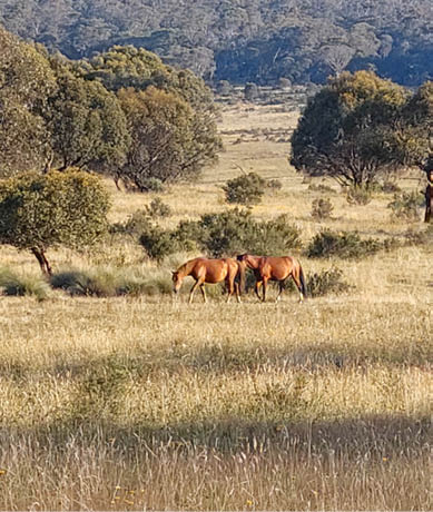
Wild Brunbies
42 | Bushwalk April 2024
